Showing 800 items
matching heritage planning
-
 Victorian Aboriginal Corporation for Languages
Periodical, Australian Institute of Aboriginal and Torres Strait Islander Studies, Australian Aboriginal studies : journal of the Australian Institute of Aboriginal and Torres Strait Islander Studies, 2010
Mediating conflict in the age of Native Title Peter Sutton (The University of Adelaide and South Australian Museum) Mediators have played roles in managing conflict in Aboriginal societies for a long time. This paper discusses some of the similarities and differences between older customary mediator roles and those of the modern Native Title process. Determinants of tribunal outcomes for Indigenous footballers Neil Brewer, Carla Welsh and Jenny Williams (School of Psychology, Flinders University) This paper reports on a study that examined whether football tribunal members? judgments concerning players? alleged misdemeanours on the sporting field are likely to be shaped by extra-evidential factors that disadvantage players from Indigenous backgrounds. Indigenous and non-Indigenous Australian Football League (AFL) players, matched in terms of their typical levels of confidence and demeanour in public situations, were interrogated in a mock tribunal hearing about a hypothetical incident on the football field. The specific aim was to determine if the pressures of such questioning elicited behavioural differences likely to be interpreted as indicative of testimonial unreliability. Mock tribunal members (number = 103) then made judgments about the degree to which a number of behavioural characteristics were evident in the players? testimonies. Under intense interrogation, Indigenous players were judged as presenting less confidently and displaying a greater degree of gaze aversion than non-Indigenous players. These behavioural characteristics are commonly ? and inappropriately ? used as cues or heuristics to infer testimonial accuracy. The paper discusses the implications for Indigenous players appearing at tribunal hearings ? and for the justice system more broadly. Timothy Korkanoon: A child artist at the Merri Creek Baptist Aboriginal School, Melbourne, Victoria, 1846?47 ? a new interpretation of his life and work Ian D Clark (School of Business, University of Ballarat) This paper is concerned with the Coranderrk Aboriginal artist Timothy Korkanoon. Research has uncovered more about his life before he settled at the Coranderrk station in 1863. Evidence is provided that five sketches acquired by George Augustus Robinson, the former Chief Protector of Aborigines, in November 1851 in Melbourne, and found in his papers in the State Library of New South Wales, may also be attributed to the work of the young Korkanoon when he was a student at the Merri Creek Baptist Aboriginal School from 1846 to 1847. Developing a database for Australian Indigenous kinship terminology: The AustKin project Laurent Dousset (CREDO, and CNRS, Ecole des Hautes Etudes en Sciences Sociales), Rachel Hendery (The Australian National University), Claire Bowern (Yale University), Harold Koch (The Australian National University) and Patrick McConvell (The Australian National University) In order to make Australian Indigenous kinship vocabulary from hundreds of sources comparable, searchable and accessible for research and community purposes, we have developed a database that collates these resources. The creation of such a database brings with it technical, theoretical and practical challenges, some of which also apply to other research projects that collect and compare large amounts of Australian language data, and some of which apply to any database project in the humanities or social sciences. Our project has sought to overcome these challenges by adopting a modular, object-oriented, incremental programming approach, by keeping metadata, data and analysis sharply distinguished, and through ongoing consultation between programmers, linguists and communities. In this paper we report on the challenges and solutions we have come across and the lessons that can be drawn from our experience for other social science database projects, particularly in Australia. A time for change? Indigenous heritage values and management practice in the Coorong and Lower Murray Lakes region, South Australia Lynley A Wallis (Aboriginal Environments Research Centre, The University of Queensland) and Alice C Gorman (Department of Archaeology, Flinders University) The Coorong and Lower Murray Lakes in South Australia have long been recognised under the Ramsar Convention for their natural heritage values. Less well known is the fact that this area also has high social and cultural values, encompassing the traditional lands and waters (ruwe) of the Ngarrindjeri Nation. This unique ecosystem is currently teetering on the verge of collapse, a situation arguably brought about by prolonged drought after decades of unsustainable management practices. While at the federal level there have been moves to better integrate typically disparate ?cultural? and ?natural? heritage management regimes ? thereby supporting Indigenous groups in their attempts to gain a greater voice in how their traditional country is managed ? the distance has not yet been bridged in the Coorong. Here, current management planning continues to emphasise natural heritage values, with limited practical integration of cultural values or Ngarrindjeri viewpoints. As the future of the Coorong and Lower Murray Lakes is being debated, we suggest decision makers would do well to look to the Ngarrindjeri for guidance on the integration of natural and cultural values in management regimes as a vital step towards securing the long-term ecological viability of this iconic part of Australia. Hearts and minds: Evolving understandings of chronic cardiovascular disease in Aboriginal and Torres Strait Islander populations Ernest Hunter (Queensland Health and James Cook University) Using the experience and reflections of a non-Indigenous clinician and researcher, Randolph Spargo, who has worked in remote Aboriginal Australia for more than 40 years, this paper tracks how those at the clinical coal-face thought and responded as cardiovascular and other chronic diseases emerged as new health concerns in the 1970s to become major contributors to the burden of excess ill health across Indigenous Australia. The paper cites research evidence that informed prevailing paradigms drawing primarily on work in which the clinician participated, which was undertaken in the remote Kimberley region in the north of Western Australia. Two reports, one relating to the Narcoonie quarry in the Strzelecki Desert and the other concerning problematic alcohol use in urban settings.maps, b&w photographs, colour photographs, tablesstrzelecki desert, native title, timothy korkanoon, merri creek baptist aboriginal school, austkin project, coorong, lower murray lakes district, south australia, indigenous health -
 Lakes Entrance Regional Historical Society (operating as Lakes Entrance History Centre & Museum)
Book, East Gippsland Regional Planning Committee, Sites of Historical Significance in the East Gippsland Region, 1980
A description list of sits of historical significance in teh East Gippsland Region Victoria as at 1979-1980. A bibliography of historical material in published form is also included. Illustrationheritage, social history -
Lakes Entrance Regional Historical Society (operating as Lakes Entrance History Centre & Museum)
Book, Reverend George Cox, Heritage Rivers and Natural Catchment Areas Draft Management Plans Volume 3 Gippsland, 1997
History of Churches and Schools in Gippsland Victoriareligion, schools, gippsland -
Lakes Entrance Regional Historical Society (operating as Lakes Entrance History Centre & Museum)
Book, Dept of Natural Resources and Environment Victoria Publisher, Fisheries Victoria Management Report Series Lake Tyers Fisheries Reserve Management Plan No 43, 1997
... Draft Management Plans prepared under the Heritage Rivers... Management Plans prepared under the Heritage Rivers Act set out ...Draft Management Plans prepared under the Heritage Rivers Act set out the proposed basis for future management of Heritage Rivers and Natural Catchment Areas. Gippsland catchments are significant for the essential undisturbed conditionISBN 0730667936environment, waterways -
Lakes Entrance Regional Historical Society (operating as Lakes Entrance History Centre & Museum)
Book, Vantree Pty Ltd Shearwater Environmetal Management, East Gippsland - Creating a Community Heritage Plan, 2002
... East Gippsland - Creating a Community Heritage Plan... Gippsland - Creating a Community Heritage Plan Book Vantree Pty Ltd ...This plan provides for the long-term Coastal Action Planwaterways, environment, tourism, boats and boating -
 Sunshine and District Historical Society Incorporated
Photograph (1950), The Migrant Ship HELLENIC PRINCE, Copy 27/01/2014 - (Original Post Card circa 1950)
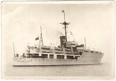
In 1949 the HELLENIC PRINCE with its 3 hospitals, 2 cinemas, and air conditioned accommodation was chartered by the International Refugee Organisation to transport displaced persons from Europe to Australia. Its first trip was to Sydney where it arrived with 1000 passengers on 5 December 1949. On the third trip it left Naples on 23 March 1950, and arrived in Fremantle on 20 April 1950, and in Melbourne on 25 April 1950. The men and women were separated for the voyage with my father sleeping on a hammock in a large room with other men, while my mother, my brother, and I had bunks in a shared cabin. On board were displaced persons ex Bagnoli Camp Italy, some of whom later built their bungalows on the grassy and rocky paddocks near Sunshine Victoria, and began to establish a new life in a new country. A few of the families that arrived on the third trip and purchased land in the Dunkeld Ave - Sandford Ave area of North Sunshine (Birmingham Estate) were Janczak, Kolanowicz, Mroz, Pawlak, Rasztabiga, Skrobalak, Szydlowski, Witkowski, and Zielinski. Some friends settled elsewhere in Sunshine. The family Tabaka went to West Sunshine just over the Derby Rd Bridge, while the family Wojcik went to Ardeer. The ship first started service in 1929 for the Royal Australian Navy as the HMAS ALBATROSS. It had a standard displacement of 4,800 tons and was 443 feet 7 inches (135.2 metres) long, and its top speed during trials reached 22 knots (41 km/hr). It was built at Cockatoo Island Dockyard as Australia's first Aircraft Carrier (seaplanes), but the aircraft that it was designed for were retired just before the ship went into service. A new plane specifically designed to work with the Albatross began operations after the ship was decommissioned in 1933, and placed into reserve in Sydney Harbour. Seaplanes continued to operate from the anchored ship. (Click on the Link 'HMAS Albatross (1)' situated above the Object Registration number to view pictures of the HMAS Albatross on the Navy web site). In 1938 the ship was recommissioned and transferred to the Royal Navy as part payment for the light cruiser Hobart. The ship then did military service for the Royal Navy during World War 2. It did patrol and escort duties in the southern Atlantic, and from mid 1942 in the Indian Ocean. By early 1944 the ship was converted so that it could repair landing craft and other support vessels off Sword and Juno beaches. The ship managed to return 132 craft into service and to save 79 others from total loss. On 11 August 1944 Albatross was torpedoed with the loss of either 50 or 66 personnel, but was able to be towed back to Portsmouth. After repairs she did a short service as a minesweeper depot ship, and following that was placed into reserve on 3 August 1945. In August 1946 the ship was sold for commercial use but the plans to convert it into a luxury liner or a floating cabaret fell through. The ship was again sold on 14 November 1948 to the British-Greek Yannoulatos Group, who renamed it HELLENIC PRINCE in recognition of the birth of Prince Charles and his Greek heritage. After conversion into a passenger ship the Hellenic Prince made several trips to Australia transporting displaced persons, however apparently not all trips were pleasant for the passengers. In the on board newsletter 'Kangaroo' dated 5 January 1951, the ship's master P. C. King expressed his indignation about the behaviour of passengers and made accusations of mutiny. According to some immigrants the conditions were appalling and overcrowded with 1200 passengers. Passengers were supposedly required to work and were paid with Woodbine cigarettes. The drinking water ran out, the freezer broke down, and fresh food that was brought on board went to the crew. Sea sickness was rife because the ship was rarely level due to malfunctioning pumps. (The newsletter 'Kangaroo' can be viewed at the Museum Victoria web site by clicking the Link 'Newsletter - Kangaroo'). In 1953 during the Mau Mau uprising the Hellenic Prince was used to transport troops to Kenya, and in 1954 the ship came to an end in a scrap yard at Hong Kong. THE ABOVE INFORMATION WAS COMPILED FROM; (1) http://en.wikipedia.org/wiki/HMAS_Albatross_(1928) (accessed 11/2/2013), (2) An article by Graeme Andrews found at http://www.afloat.com.au/afloat-magazine/2011/july-2011/The_boat_people_of_the _forties_and_fifties#.UuYY6ou4apo (accessed 27/1/14), (3) http://museumvictoria.com.au/collections/items/273166/newsletter-kangaroo-hellenic-prince-5-jan-1951 (accessed 27/1/14), (4) National Archive search starting at; www.naa.gov.au/collection/search/index.aspx (accessed 27/1/14), (5) http://www.flickr.com/photos/41311545@N05/3864781978 (accessed 29/1/14). Hellenic Prince has a significance to Sunshine Victoria because some of the displaced people from Europe, who arrived in Melbourne on Anzac Day 1950, were among the first people to settle in the grassy and rocky paddock areas of North Sunshine. These settlers established a residential suburban area out of the paddocks. In those early days there were no services and the planned roads were basically just drawings on a map. The ship is also significant because it was named in recognition of the birth of Prince Charles. In the ship's former life as the HMAS Albatross the significance is that it was built in Australia as our country's first Aircraft Carrier (seaplanes).New photograph made from a scanned copy of a circa 1950 Post Card featuring the ship on calm water.Hellenic Prince / Hong Konghellenic prince, migrant ship, displaced persons, refugees, international refugee organisation, bagnoli camp, hmas albatross, yannoulatos group -
 Box Hill Historical Society
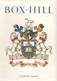
Book, Lemon, Andrew, Box Hill, 1978
History of Box Hill from its beginning to 1978. Index; photos; plan of Box Hill in 1905 on endpapers; Members of Council in order of election. Presentation Edition: #15box hill -
 Westbourne Grammar Heritage Collection
Photograph - The Site for Westbourne 1977
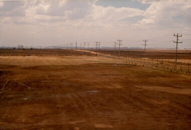
In 1975 a School Council subcomittee was formed to select a new principal to instigate the development of secondary schooling at Williamstown Grammar. By 1977 the appointed principal, John Roberts Pascoe, had worked tirelessly assessing options in and around Williamstown and looking for support for the school's expansion plans. He found that support in the Werribee Council and Werribee community, which recognised the potential of an independent school for the expanding area. In 1977, based on demographic research and feasibility studies, fifty acres of land was purchased on Sayers Rd. at Truganina (then Werribee). This photograph shows that land, the site for the new secondary school for Williamstown Grammar, looking east at the corner of Sayers Rd & Marquands Rd, which would be a very different view today.Colour photograph of a cloudy sky and cleared land with a perspective line of telegraph poles extending from the right into the middle background.campus, secondary, expansion -
Stawell Historical Society Inc
Map - Drawings, Wendy Jacobs, Western Highway Community Precinct Development Structural Drawings, 2014
501 Slab and Footing Plan. 502 Slab and Footing Details. 505 Roof Framing Plan 506 Steel Framing Elevations - Sheet 1. 507 Steel Framing Elevations and Sections - Sheet 2 508 Steel Framing Details - Sheet 1 509 Steel Framing Details - Sheet 2 SN1 General Notes, Site map & Drawing Index Used in building Historical Society Building Eight (8) A1 Printed plans Structural DrwaingsWendy Jacobs Architect & Heritage consultant may 2014 -
Stawell Historical Society Inc
Map - Drawings, Wendy Jacobs, Western Highway, 2014
WD 1/13 - Site Plan WD 2/13 - Existing Conditions & Demolition Plan WD 3/13 - Floor Plan WD 4/13 - Elevations WD 5/13 - Sections AA & BB WD 6/13 - Sections CC WD 7/13 - Sections DD, EE & FF WD 9/13 - Roof Plan WD 10 /13 Reflected Ceiling Plan WD 12/13 - Toilet & Meeting Cup'd Details WD 13/13 - DetailsEleven (11) A1 Printed MapsWendy Jacobs Architect & Heritage Consultant Nov 2014 -
Koorie Heritage Trust
Book, Lo Bianco, Joseph, Victoria: Languages action plan, 1989
To our society and economy language skills overlap strongly with our multilingual population, our place in the Asian-Pacific region and our future as a trading nation in a multilingual world. We must now attend to increasing the availability and the appropriateness of the resources at our disposal..and matching these to our needs and objectives. With this action plan we have the framework to do this.98 p. : ill. ; 26 cm.To our society and economy language skills overlap strongly with our multilingual population, our place in the Asian-Pacific region and our future as a trading nation in a multilingual world. We must now attend to increasing the availability and the appropriateness of the resources at our disposal..and matching these to our needs and objectives. With this action plan we have the framework to do this.language policy -- australia. | english language -- study and teaching -- victoria. | education, bilingual -- victoria. | languages, modern -- study and teaching -- victoria. -
Koorie Heritage Trust
Book, Broom, Leonard, A blanket a year, 1973
Land rights, perhaps the best known of Aboriginal grievances, is bitterly expressed in 'All they give us now for our land is a blanket once a year'. Yet, as Broom and Jones show in this book, the Aborigines are disadvantaged in every way. No one knows who are Aborigines, how many there are, what jobs they hold, what education they have received. Yet, until this extraordinary ignorance is rectified, there is no basis for planning vital improvements. The authors stress the urgent need for public authorities to gather information on Aboriginal health, housing, employment, and education. Without this information no attempt to overcome the gross inequalities can hope to succeed. A Blanket a Year offers constructive professional help. It is vital reading for politicians, administrators, social workers, educationists, and for all fair-minded Australians.98 p. ; notes; tables; references; 23 cm.Land rights, perhaps the best known of Aboriginal grievances, is bitterly expressed in 'All they give us now for our land is a blanket once a year'. Yet, as Broom and Jones show in this book, the Aborigines are disadvantaged in every way. No one knows who are Aborigines, how many there are, what jobs they hold, what education they have received. Yet, until this extraordinary ignorance is rectified, there is no basis for planning vital improvements. The authors stress the urgent need for public authorities to gather information on Aboriginal health, housing, employment, and education. Without this information no attempt to overcome the gross inequalities can hope to succeed. A Blanket a Year offers constructive professional help. It is vital reading for politicians, administrators, social workers, educationists, and for all fair-minded Australians.aborigines. social planning. information requirements. australia. surveys | aboriginal australians -- social conditions. | australia -- social policy. | -
Koorie Heritage Trust
Document - Report, Bambrook, Anne, Report on the status of Victorian Aboriginal communities in enterprise and economic development, 1993
The Committee commissioned the research and reportas part of a process leading to a statewide economic development conference and the development of a draft strategy plan for action.p.127; glossary; appendices; figs.; 30 cm.The Committee commissioned the research and reportas part of a process leading to a statewide economic development conference and the development of a draft strategy plan for action.aboriginal communites - retail management; tourism; business development. -
Koorie Heritage Trust
Book, Aboriginal Affairs Victoria in conjunction with the Kerrup Jmara Elders Aboriginal Corporation, Lake Condah Heritage Management Strategy and Plan, 1993
... Lake Condah Heritage Management Strategy and Plan.... Lake Condah Heritage Management Strategy and Plan Book ...During its 1977/78 summer field school season, the (then) Victoria Archaeological Survey began recording and mapping the stone fish trap and 'house' sites along the southern margins of Lake Condah, near Portland Victoria. This and subsequent archaeological work at Lake Condah and in the general region demonstrates that, on the basis of a number of criteria, the Aboriginal heritage sites found here are significant.vii, 388 p., [11]. leaves. : ill., foldout maps. ; 30 cm.During its 1977/78 summer field school season, the (then) Victoria Archaeological Survey began recording and mapping the stone fish trap and 'house' sites along the southern margins of Lake Condah, near Portland Victoria. This and subsequent archaeological work at Lake Condah and in the general region demonstrates that, on the basis of a number of criteria, the Aboriginal heritage sites found here are significant.conservation of natural resources -- victoria -- condah, lake, region. | aboriginal australians -- victoria -- condah, lake, region -- antiquities. -
Koorie Heritage Trust
Book, Osborn, Betty et al, Maryborough, a social history, 1854-1904, 1985
The authors have given a picture of Maryborough from the earliest rough life on the diggings when a full-scale rebellion was narrowly averted over an incident at Tipperary Hill, to life at the turn of the century when a more sophisticated society had developed. Maryborough-History-1854-1904. Aborigines, Australian-Maryborough-Jajowurrong. (Dja Dja Wurrung); Aborigines-poisoningxx, 420 p. : ill., facsims., maps, plans, ports. ; 24 cm.The authors have given a picture of Maryborough from the earliest rough life on the diggings when a full-scale rebellion was narrowly averted over an incident at Tipperary Hill, to life at the turn of the century when a more sophisticated society had developed. Maryborough-History-1854-1904. Aborigines, Australian-Maryborough-Jajowurrong. (Dja Dja Wurrung); Aborigines-poisoningmaryborough (vic.) -- history. -
Koorie Heritage Trust
Book, Beresford, Quentin, Our State of Mind. Racial Planning and the Stolen Generations, 1998
The book examines the racial thinking behind the developments of child removal and assimilation.8-295 P.; notes; index; bib.; 21 cm.The book examines the racial thinking behind the developments of child removal and assimilation.stolen generations-government policy-?ustralia, assimilation-government policies -
Koorie Heritage Trust
Book, Ball, Desmond, Aborigines in the defence of Australia, 1991
This book is designed to provide all the information required for informed consideration of the potential role of Aborigines in the defence of Australia, for clarification and resolution of the disparate and complex issues involved and for the design of policy initiatives to realise the potential of Aborigines in Australia's defence planning and operations.vii-xxii; 240 P.; figs.; maps; notes; bib.; index; tables; 23 cm.This book is designed to provide all the information required for informed consideration of the potential role of Aborigines in the defence of Australia, for clarification and resolution of the disparate and complex issues involved and for the design of policy initiatives to realise the potential of Aborigines in Australia's defence planning and operations.world war, 1939-1945 -- participation, aboriginal australian. | world war, 1939-1945 -- participation, torres strait islander. | aboriginal australian soldiers. | australia -- armed forces -- minorities -- history. -
Koorie Heritage Trust
Book, Baragwanath, W, Memoirs of the Geological Survey of Victoria : No. 15 The Aberfeldy District, Gippsland, 1925
15 v. : ill., plates, maps, plans, diagrs. ; 34 cm. lcsh: 1. geology -- victoria -- periodicals. 2. geology -- victoria. i. geological survey of victoria. ii. victoria. dept. of mines. -
Koorie Heritage Trust
Book, Brooke, Brian (Brian J.) et al, A story of Horsham : a municipal century, 1982
Copy signed by both authors.278 p. : ill., facsims., plan, ports. ; 21 x 29 cm. Copy signed by both authors.1. horsham (vic.) -- history. i. finch, alan, 1934-, 2. aboriginal inhabitants. p.2-4, 3."mulga fred" -
Koorie Heritage Trust
Book, Burchett, Winston H. (Winston Harold), East Melbourne 1837 - 1977 : people, places, problems, 1978
xiii, 177p. : ill. ; tables; 23 x 29cm. lcsh: 1. city planning -- victoria -- east melbourne. 2. east melbourne (vic.) -- history. 3. east melbourne (vic.) -- buildings, structures, etc. -
 Whitehorse Historical Society Inc.
Document, Nomination for National Trust Classification, 1/07/1997 12:00:00 AM
Nomination for Nation Trust ClassificationNomination for Nation Trust Classification of former Shire of Blackburn and Mitcham Shire Chambers, 360 Whitehorse Road, Nunawading. Prepared by Nunawading and District Historical Society IncNomination for Nation Trust Classificationnational trust of australia (victoria), municipal chambers, nunawading and district historical society inc, whitehorse planning scheme, whitehorse road, nunawading, no. 360, victoria. country roads board, vicroads, r. m. king, architect, heritage studies, city of nunawading, shire of blackburn and mitcham, jones, anne -
Whitehorse Historical Society Inc.
Article, Nunawading Tree policy, 1993
... Mitcham melbourne City of Nunawading Town Planning Nunawading ...Council advertisements re a draft policy relating to tree management and retention, also for expressions of interest from community representatives for a new Nunawading Heritage Study Committee.Council advertisements re a draft policy relating to tree management and retention, also for expressions of interest from community representatives for a new Nunawading Heritage Study Committee.Council advertisements re a draft policy relating to tree management and retention, also for expressions of interest from community representatives for a new Nunawading Heritage Study Committee.city of nunawading, town planning, nunawading heritage steering committee, trees -
Whitehorse Historical Society Inc.
Pamphlet, Landscaping is your heritage
Nunawading Council brochure re redevelopment cooperation with council to minimize destruction of mature trees and significant vegetation.Nunawading Council brochure re redevelopment cooperation with council to minimize destruction of mature trees and significant vegetation.Nunawading Council brochure re redevelopment cooperation with council to minimize destruction of mature trees and significant vegetation.town planning, city of nunawading, trees -
Whitehorse Historical Society Inc.
Article, A Living, working view of our heritage, 1992
Matheson's Orchard, the last working orchard in NunawadingMatheson's Orchard, the last working orchard in Nunawading will soon be open to the public. Council purchased the orchard in 1988. The plan is to run the orchard as it would have operated in the 1930's providing a living and working view of Nunawading's heritage. The eldest child, Marjory, wife of Rev Rhys miller is writing a history of the orchard for Council.Matheson's Orchard, the last working orchard in Nunawading orchards, matheson, charles, city of nunawading -
Whitehorse Historical Society Inc.
Document, Former Standard Brickworks, Box Hill, 2001
Documents relating to history, conservation and use of the former Standard Brickworks, Box Hill.Documents relating to history, conservation and use of the former Standard Brickworks, Box Hill. Conservation and Management Plan and Sort term Maintenance Plan prepared for Phileo Australia by Bryce Rawarth Pty Ltd, April 2001. Heritage Victoria Permit Application submitted on behalf of The Evangelical Community Church, by Adam Lovell & Associates Pty Ltd, December 2001.Documents relating to history, conservation and use of the former Standard Brickworks, Box Hill. standard brick company, allom lovell & associates, bryce rawarth pty ltd, phileo australia ltd, heritage victoria -
Whitehorse Historical Society Inc.
Document, Whitehorse Planning Scheme, 1/05/2001 12:00:00 AM
... on Heritage overlay inclusions. Whitehorse Planning Scheme Document ...Amendment C3 Part 2 : Panel report with extract from minutes of Whitehorse City Council recording Council's resolutions to adopt the Panel's recommendations on Heritage overlay inclusions.Amendment C3 Part 2 : Panel report with extract from minutes of Whitehorse City Council recording Council's resolutions to adopt the Panel's recommendations on Heritage overlay inclusions.Amendment C3 Part 2 : Panel report with extract from minutes of Whitehorse City Council recording Council's resolutions to adopt the Panel's recommendations on Heritage overlay inclusions.whitehorse planning scheme, historic buildings, city of whitehorse, mount pleasant road, nunawading, no 129, longland road, mitcham, no 5, strathdon orchard, australian road research board, burwood heights uniting church, boronia road, vermont, no 142, junction road, blackburn north, no 17-21, lucknow street, mitcham no 55, haines street, no 38, gordon crescent, blackburn, no 18, blackburn primary school, no. 2923 -
Whitehorse Historical Society Inc.
Article, All Over for PUB's Heritage, 2015
... Whitehorse Council has abandoned its plans to give heritage... Council has abandoned its plans to give heritage protection ...Whitehorse Council has abandoned its plans to give heritage protection to the Burvale Hotel.Whitehorse Council has abandoned its plans to give heritage protection to the Burvale Hotel.Whitehorse Council has abandoned its plans to give heritage protection to the Burvale Hotel.city of whitehorse, burvale hotel -
Whitehorse Historical Society Inc.
Article, Heritage or heresy, 1/12/1993 12:00:00 AM
Article on the management plan for Schwerkolt Cottage being prepared for Nunawading Council by Landscape Australia consultants.Article on the management plan for Schwerkolt Cottage being prepared for Nunawading Council by Landscape Australia consultants.Article on the management plan for Schwerkolt Cottage being prepared for Nunawading Council by Landscape Australia consultants.schwerkolt cottage, city of nunawading, gray, bill, cox, george, landscape australia consultants -
Whitehorse Historical Society Inc.
Document, Whitehorse Planning Scheme Amendment C52, 28/07/2004 12:00:00 AM
... Planning and Environment Act 1987, application of a Heritage ...Explanatory Report of Amendment C52 under Planning and Environment Act 1987, application of a Heritage overlay.Explanatory Report of Amendment C52 under Planning and Environment Act 1987, application of a Heritage overlay.Explanatory Report of Amendment C52 under Planning and Environment Act 1987, application of a Heritage overlay.planning development, city of whitehorse, thomas street, mitcham, whitehorse planning scheme -
Whitehorse Historical Society Inc.
Article, Volunteers set to work on heritage grounds, 2006
Volunteers to be enlisted to restore historic Crown Land abutting Schwerkolt Cottage, known as 'The Horse Paddock' (photo)Volunteers to be enlisted to restore historic Crown Land abutting Schwerkolt Cottage, known as 'The Horse Paddock' (photo) Judith Fry, Barbara Gardiner, Rob Hulls (Vic Planning & environment Minister), Sharon Ellis (Whitehorse Mayor)Volunteers to be enlisted to restore historic Crown Land abutting Schwerkolt Cottage, known as 'The Horse Paddock' (photo)voluntary workers, schwerkolt cottage, hull, rob, ellis, sharon, fry, judith, gardiner, barbara