Showing 623 items
matching landscape gardener
-
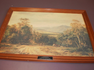 Wangaratta High School
WHS Art, 1986
Landscape painting of an Australian country road with horses and carriages, with a bushland background, in a brown wooden frame. Awarded to Wangaratta High School-Goulburn north east region, by the Australian Natives' Association for the most improved school gardens and grounds in 1986 -
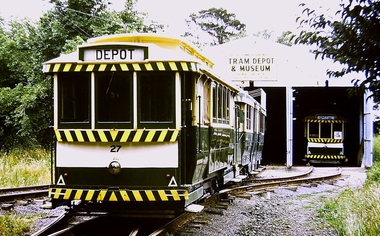 Ballarat Tramway Museum
Photograph - Digital image, Chris Phillips, c1975
Yields information about the BTPS depot c1975 and its surrounds.Digital image of No. 27, 38 and 14 on the BTPS Depot fan c1975. Shows the track layout prior to landscaping and the long grass on the south side.trams, tramways, btps, depot, tram 27, tram 38, tram 14 -
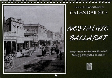 Ballarat Tramway Museum
Ephemera - Calendar, Ballarat Historical Society, 2014
Photograph of the fundraising committee, and social function for The Most Popular Conductress Competition award, held on 30/9/1944 at the Ballarat City Rowing Club, after the formal announcement on 31/8/1944 at the Melbourne Town Hall ball.Demonstrates a photograph of the fundraising committee.Calendar - A4 landscape - wire bound produced for 2015.most popular conductress, sylvia mitchell, tramways, red cross, ballarat -
 Ballarat Tramway Museum
Photograph - Digital image Set of 10, George Coop, 1968 - 1970
Yields information about the tram operations and the landscape views of the Sturt St median strip.Ten (10) Digital images taken by George Coop during the period 1968 - 1970, of SEC trams in Sturt St, between the City and Pleasant Streets. .1 - Tram 26 climbing the Sturt St hill to Lydiard St, with the Cook's Private Hotel, the Commonwealth Bank and the National Mutual Life building in the background. Photo taken from the Titanic Bandstand. .2 - Tram 40 Sturt St, enough to Lydiard St North just before Raglan St. Has a lady passenger by the tram stop. .3 - Tram 30 - Sturt St north side, near Armstrong St, - has a blue framing line around the photograph. .4 - Tram 39, Sturt St, near Doveton St, shows the rotunda in the median strip. .5 - Tram 18, with median step in view. .6 - Tram 31, with two Johnnie Walker whiskey roof adverts, outside the National Mutual Life building with the Alan Bros Jewellers and Golden Star Chinese Cafe in the view. .7 - Tram 31, Sturt St south side with Town Hall and the Golden City Hotel in the view. Tram has destination of Gardens via Drummond North. .8 - Tram 41 - ditto - going to Sebastopol. .9 - Tram 13, south side, Gardens via Sturt West, about , near Ripon St, with the Ampol service station in the background and about to pick up a lady passenger .10 - Tram 17, near Doveton St. Has a Twin Lakes sign and a Wilkinson Sword Razor Bladese roof advert. trams, tramways, sturt st, raglan st, passengers, doveton st, tram 26, tram 40, tram 30, tram 39, tram 18, tram 31, tram 41, tram 13, tram 17 -
 Ballarat Tramway Museum
Ephemera - Ticket, Australian Railway Historical Society (ARHS), ARHS Tram tour tickets, Feb. 1967
Ticket used for passengers on the Australian Railway Historical Society (Vic. Div.) tour to Ballarat and Ballarat trams on 25 Feb. 1967. Number "0189", printed on Edmondson pasteboard card, with the name "Australian Railway Historical Society" and ticket number pre printed, and the words "BALLARAT TRAM TOUR 25-2-67", stamped in black ink using a hand stamp. Card is off white with two light blue vertical stripes on both sides. Ticket printed in landscape format. See image for details.trams, tramways, tickets, arhs, tours -
 Ballarat Tramway Museum
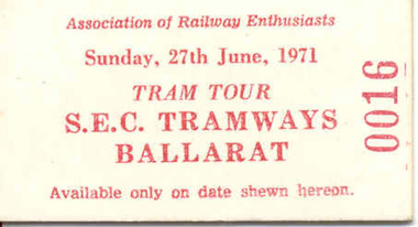
Ephemera - Ticket, Association of Railway Enthusiasts (ARE), ARE Tram tour ticket, Jun. 1971
Ticket used for passengers on the Association of Railway Enthusiasts (ARE) tour to Ballarat and Ballarat trams on 27 June 1971. Number "0016", printed on Edmondson sized cardboard, with the name "Association of Railway Enthusiasts", date and purpose details and ticket number. All in red ink on white cardboard. Ticket printed in landscape format. See image for details. On rear printed in red ink is availability and condition details.trams, tramways, tickets, are, tours -
 Ballarat Tramway Museum
Ephemera - Ticket/s, Victorian Railways, BTPS Mirboo North tour, 1974
Edmondson pasteboard railway ticket, No. 14, dated 25 April 1974, for use on a Ballarat Tramway Preservation Society special train from Morwell to Mirboo North and return. See Reg. item 1819 for S circular or Special Train Notice for the tour. Ticket base is off white with eight light orange vertical bands equally spaced along the ticket, which is printed in landscape format. Notes as being "Available by Goods Train each way on day of issue only.", for Adult - Economy and Adult - Economy. Ticket number in reverse printing. See Reg Item 4676 for a group photo.trams, tramways, tickets, btps, morwell - mirboo north, tours -
 Ballarat Tramway Museum
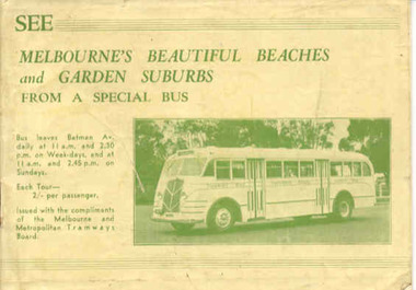
Book, Melbourne and Metropolitan Tramways Board (MMTB), "See Melbourne's Beautiful Beaches and Garden Suburbs from a Special Bus", 1939
Thirty two page landscape booklet on semi gloss white paper with off white cover and single supplementary white sheet tipped onto the inside of the front cover titled "See Melbourne's Beautiful Beaches and Garden Suburbs from a Special Bus". Saddle stapled, printed letterpress. Text printed in black and green ink. Cover green ink only. The book advertising MMTB's Special tourist bus, giving overall tour details on page 1, including fares, time of departures and reservations. Each tour has a map showing the route, details of the tour route with notes and photographs. Page 14 shows a maximum traction tram on the reserved track in Dandenong road and page 30, W2 488 outbound in Victoria Parade. Page 32 has an advertisement for the Round Trip by Tram 1/-. Front cover has details of the departure times and fares and a photo of the Tourist Bus. The supplementary sheet has been prepared for the tours that operated daily from Sun Sept. 17 to Friday May 31, except Anzac Day. Melbourne Tram Museum has a similar book - different bus - Reg Item 99 - 1938-39 version..trams, tramways, mmtb, bus tours, melbourne, sightseeing -
 Ballarat Tramway Museum
Document - Report, John Patrick Pty Ltd, "Ballarat Botanical Gardens Masterplan - Final Draft", Nov. 1995
Twelve page (7 A4 pages, 5 A3 folded pages), photocopied as the final draft of the Ballarat Botanical Gardens Masterplan November 1995. Prepared by Landscape Heritage Consultants, John Patrick Pty Ltd. Report stapled in the top left hand corner. Notes include references to the tramway facilities. The 5 A3 sheets show the proposed plan, including the tramway and an extension to the shed. See July 1995 Fares Please! for the plan itself.On page 1, words "Depot" and a hand written change to the date of display from "29" to "6".trams, tramways, wendouree parade, ballarat botanical gardens, tramways, masterplan -
 Ballarat Tramway Museum
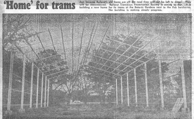
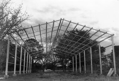
Newspaper, The Courier Ballarat, " 'Home' for trams", 16/05/1972 12:00:00 AM
... Ballarat Tramway Museum South Gardens Reserve Wendouree ...Yields information about the construction of the depot building for the BTPS in the south Gardens Reserve and the landscape at the time.Newspaper clipping from The Courier, Ballarat, dated Tuesday, 16/5/1972 titled " 'Home' for trams". Features a photograph of the erected steelwork for the new BTPS tram depot in the South Gardens Reserve. One of a large group of newspaper cuttings from John Bainbridge, 7/4/02. See Reg Item 3819 for a print of the actual photograph.btps, depot, buildings -
 Ballarat Tramway Museum
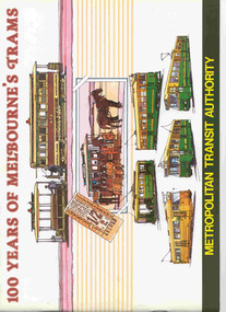
Book, G. McEldowney, "100 years of Melbourne's Trams", Nov. 1985
Thirty Two page book, A4 landscape format, saddle stapled, titled "100 years of Melbourne's Trams", published by the Metropolitan Transit Authority and the Australian Tramway and Motor Omnibus Employees Association in 1985. Colour cover featuring drawings of Melbourne trams from cable trams to articulated electric trams. Has foreword by Tom Roper, Minister for Transport. Book published to celebrate the centenary of the opening of the first cable tram in Melbourne, 11/11/1885. Reviews the history of trams in Melbourne, cable trams, horse trams, Clapp, municipal tramways, electric trams, MMTB, buses, Preston Workshops, Wattle Park and the Metropolitan Transit Authority. Notes the MTA winning the tender to building the Kowloon - Canton Light Rail system and Melbourne's Automatic Vehicle Monitoring System. Has colour photos and sepia toned (black and white) photos throughout.trams, tramways, melbourne, mmtb, cable trams, mta, horse trams -
 Ballarat Tramway Museum
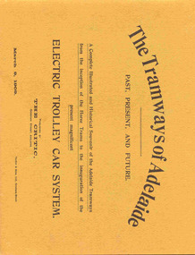
Book, The Critic and Adelaide, "The Tramways of Adelaide", c1989
Fifty four page book, A4 landscape format, with brown stipple card covers saddle stapled, printed on gloss paper, titled "The Tramways of Adelaide". Originally published by The Critic Adelaide in 1909, with facsimile production by the Australia Electric Transport Museum c1989. Features photographs of construction of the electric tram system in Adelaide, Members and Officers of the Tramway Trust, construction details, electrical equipment details and depots. Has advertisements for local suppliers including Messrs Forward, Down & Co. (Steel fabricators), Duncan and Fraser (tram builders), Newton McLaren Ltd (electrical equipment), James Martin & Co. (locomotive and equipment) and Millars' Karri and Jarrah Co.trams, tramways, adelaide, mtt, tramway construction, electrical systems -
 Ballarat Tramway Museum
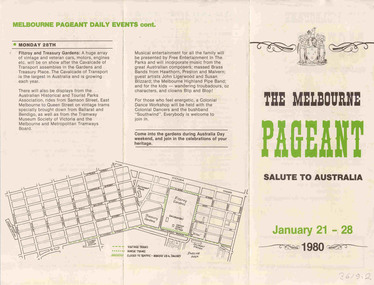
Memorabilia - Event Materials, Melbourne Pageant Committee, Australia Day Pageant 1980, 27/12/2006 12:00:00 AM
Has a strong association with the 1980 Melbourne Pageant, and the involvement of the Bus and Coach Society of Victoria in the event. Various papers giving programme detailsEvent materials associated with the 1980 Australia Day Pageant, Melbourne, 28 January 1980. .1 - Guide to all motor vehicles, including buses of the Bus and Coach Society of Victoria - fourteen duplicated pages, stapled within a printed card cover - landscape format. Centre pages has a map of the Fitzroy and Treasury Gardens. .2 - Programme of events for the period 21st Jan to Monday 28th giving details of displays throughout the Melbourne CBD area. Printed quarto sheet on art paper, folded into three vertically.trams, tramways, bcsv, melbourne, australia day -
 Ballarat Tramway Museum
Photograph - Black & White Photograph/s, The Courier Ballarat, 15/5/1972
... and the landscape at the time. tramways trams BTPS Depot Gardens Buildings ...Newspaper photograph taken by The Courier of the steel framework for the BTPS depot in the south Gardens reserve. Photo taken 15/5/1972, published 16/5/1972. See Reg. Item 2203 for the photo used in the newspaper clipping. Collected by Alan Bradley from the Ballarat Courier early 1980's. See Reg Item 4654 for a similar photo, along with 9434, and 3819.Yields information about the construction of the depot building for the BTPS in the south Gardens Reserve and the landscape at the time.Black and White copy photograph with publisher details on the rear.On rear stamped "Copyright, The Ballarat Courier Proprietary Limited."tramways, trams, btps, depot, gardens, buildings -
 Ballarat Tramway Museum
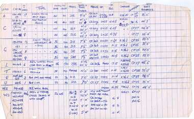
Document - Roster, State Electricity Commission of Victoria (SECV), "On and Off - Total Times of Duty", 12/10/1944 12:00:00 AM
Demonstrates aspects of the Ballarat Tramways in the middle of the 2nd world war - when the tramway traffic was at its peak. Gives details of working hours, tram operations and services for the week. Shows the additional trams to the basic service on Weekdays.Set of five type foolscap sheets - landscape format, along with a set of carbon copies, of the "On and Off" times dated 12 October 1944. Details the sign on / sign off times for each run or table number operated by Motormen / Conductors, where the first service went to, where it came in from if applicable, the number of trips it did to terminus eg G for Gardens, V for Victoria St and the total miles of that run or table. The Miles have been typed in red ink to give a column breakup. Sheets for Basic Service Weekdays, Middle Runs - Mondays to Thursdays - (additional services am, lunch, PM and theatre), Middle runs for Fridays, Middle Runs Saturdays, and Sundays. Has initials LD in top right hand corner next to date. This is not Les Denmead.In top right hand corner in black ink "B.T.P.S. Cat No. 801"trams, tramways, ballarat, rosters, employees, shifts, timetables -
 Ballarat Tramway Museum
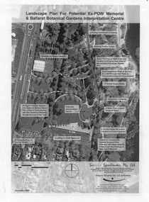
Document - Photocopy, Gregory Burgess Pty Ltd and Architects and, "Landscape Plan for Potential Ex-POW Memorial & Ballarat Botanical Gardens Interpretation Centre", Nov. 2005
Three page photocopy consultation document titled "Landscape Plan for Potential Ex-POW Memorial & Ballarat Botanical Gardens Interpretation Centre" showing concept plans for the development to the east of the tram depot and for the POW memorial. The project did not proceed. Prepared by Gregory Burgess Pty Ltd, Architects, November 2005.trams, tramways, gardens, depot, botanical gardens -
 Ballarat Tramway Museum
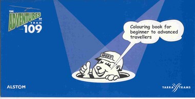
Domestic object - Colouring Book, Yarra Trams and Warwick Hook, "The Adventures of Tram 109", Dec 2003?
12 page colouring book, with heavy card covers, titled "The Adventures of Tram 109", with illustrations by Warwick Hook, published at the time of the opening to Box Hill of route 109 from Mont Albert. Published jointly by Alstom and Yarra Trams. Features 10 pages of landscape size cartoons each featuring a single story line and a four panel cartoon, with a title and Harry the construction worker panel at the ends. Has Yarra trams logo and web site on the rear cover.tram, trams, box hill, yarra trams, route 109 -
 Ballarat Tramway Museum
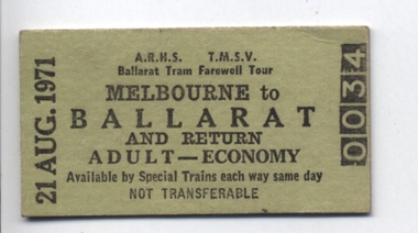
Ephemera - Ticket/s, Victorian Railways, ARHS / TMSV joint tour to Farewell Ballarat Trams, 1971
Has a strong association with the tours to mark the closure of the Ballarat Tramway system and Graeme Breydon.Edmondson pasteboard railway ticket, No. 34, dated 21 august 1971, for use on an ARHS / TMSV joint tour to Farewell Ballarat Trams - the first day of the closure of the system. Ticket base is light green, which is printed in landscape format. Notes as being "Available on the Special Train only" Adult - Economy. Ticket number in reverse printing. Ticket used by Graeme Breydon on the day of the tour. See History of the Object for further details.trams, tramways, arhs, tmsv, tickets, closure -
 Ballarat Tramway Museum
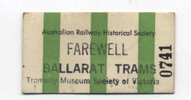
Ephemera - Ticket/s, Victorian Railways, ARHS / TMSV joint tour to Farewell Ballarat Trams, 1971
Has a strong association with the tours to mark the closure of the Ballarat Tramway system and Graeme Breydon.Edmondson pasteboard railway ticket, No. 741, dated 21 august 1971, for use on an ARHS / TMSV joint tour to Farewell Ballarat Trams - the first day of the closure of the system. Ticket base is white with three vertical green stripes, which is printed in landscape format. Has been over stamped "Farewell Ballarat Trams" and "Tramway Museum Society of Victoria". From memory, these tickets were bulk printed by the Victorian Railways for the ARHS and the over stamped for use on particular days/events, meals etc. Would have been used as the tram ticket on the day. Ticket used by Graeme Breydon on the day of the tour. See History of the Object for further details.trams, tramways, arhs, tmsv, tickets, closure -
 Ballarat Tramway Museum
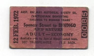
Ephemera - Ticket/s, Victorian Railways, ARHS tour to Farewell Bendigo, 1972
Has a strong association with the tours to mark the closure of the Bendigo Tramway system and Graeme Breydon.Edmondson pasteboard railway ticket, No. 0085, dated 12 Feb. 1972, for use on an ARHS tour to Farewell Bendigo prior to the closure of the system. Ticket base is pink with a thick purple stripe, which is printed in landscape format. Ticket number in reverse. Adult - Economy, available on the day of travel only and on the special train. On the rear of the ticket is the reserved seat and carriage number. Ticket used by Graeme Breydon on the day of the tour. See History of the Object for further details. Two copies held. trams, tramways, arhs, tmsv, tickets, closure -
 Ballarat Tramway Museum
Document - List, Melbourne and Metropolitan Tramways Board (MMTB), "M&MTB Rolling Stock Data - 1/10/38 with additions:- bringing data up to 27/4/1940", Apr. 1940
Three page hand written list titled "M&MTB Rolling Stock Data - 1/10/38 with additions:- bringing data up to 27/4/1940" , listing each class, car numbers, number in service, type, seating capacity - seats, crush, truck, wheelbase, motors, Horsepower, Tare Tons, Controllers, Compressors and Length over bumpers. Author lined foolscap paper in landscape format, carbon copy Extends to SW5 889, includes cable trams. Author unknown, written in CapitalsIndividual captions for each photo.mmtb, tramcars, melbourne, lists -
 Ballarat Tramway Museum
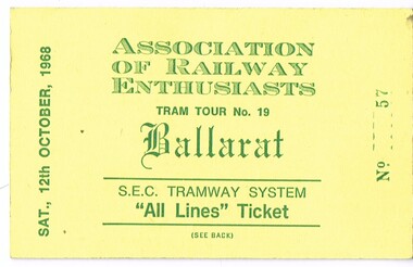
Ephemera - Ticket, Association of Railway Enthusiasts (ARE), Association of Railway Enthusiasts (ARE) tour, Oct. 1968
Ticket used for passengers on the Association of Railway Enthusiasts (ARE) tour to Ballarat and Ballarat trams on Sat. 12 October 1968. Number "0057", printed on heavy yellow cardboard with the name "Association of Railway Enthusiasts", date and purpose details and ticket number. All in green ink on white cardboard. Ticket printed in landscape format. See image for details. On rear printed in green ink is availability and condition details.trams, tramways, tickets, are, tours -
 Ballarat Tramway Museum
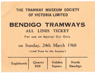
Ephemera - Ticket, Tramway Museum Society of Victoria (TMSV), TMSV Bendigo Tour, Mar. 1968
Ticket used for passengers on the Tramway Museum Society of Victoria tour to Bendigo trams on Sat. 24 March 1968. Printed on light brown card with the name the name of the TMSV, date, ticket punch positions for the four Bendigo routes. Ticket printed in landscape format with black ink. See image for details.trams, tramways, tickets, tmsv, bendigo, tours -
 Ballarat Tramway Museum
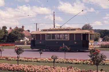
Slide - 35mm slide/s, Chas Bevan, 1971
Yields information about the Victoria St and its Gardens with a tram passing. Shows the road and garden arrangement when trams were operational.Colour slide - 35mm - of the Ballarat tram No. 11, inbound from Victoria St, with the railway bridge in the background. Note the rose bushes and gardens in the Sturt St. landscaping strips on either side of the roadway. Photo Chas Bevan."Ballarat trams 1971"tramways, trams, sturt st, gardens, victoria st, tram 11 -
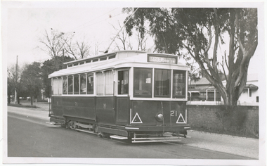 Ballarat Tramway Museum
Photograph - Digital image, Wal Jack, 25/06/1957 12:00:00 AM
Yields information the appearance of the SEC tramcar No. 21, and the Victoria St landscape in 1957.Digital image from the Wal Jack Ballarat Album of trams No. 21 outbound in Victoria St before arriving at the terminus and crossing over the Buninyong Rail bridge. Tram has the destination of Gardens via Sturt St west. In the background is the bridge brickwork. Photo taken 25 June 1957. See image i2 for rear of photograph.on rear of photo in ink, "SEC Ballarat, No. 21 ex Adelaide No. 10, in Victoria St near terminus, 25 June '57" and "W.Jack photo Neg. to D. Colquhoun"trams, tramways, victoria st, tram 21 -
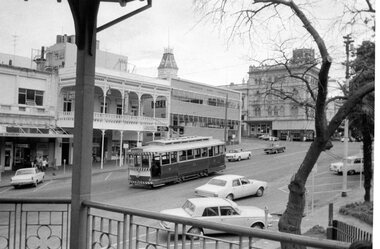
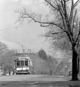
 Ballarat Tramway Museum
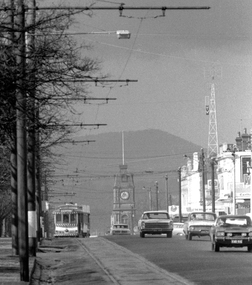
Photograph - Digital image, Peter Bruce, Sturt St into Drummond St North at 1.55pm, 1970s
Yields information about the Sturt St landscape looking east.Digital Image of a tram turning from Sturt St into Drummond St North at 1.55pm - long telephoto lens shot from about Ripon St, looking east. Mt Warrenheip in the far background. Photo taken by Peter Bruce 1970's and 1971 prior to the closure of the Ballarat System. Peter's Title of image: 1.55pmtrams, tramways, ballarat, sturt st, town hall, drummond st nth -
 Ballarat Tramway Museum
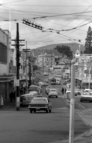
Photograph - Digital image, Peter Bruce, "Bridge St", 1970s
Yields information about the Bridge St landscape looking east.Digital image of a view looking east along Barkly St from Grenville St showing a tram a the intersection of the Mt Pleasant and Victoria St lines (Stones Corner). Has the shops on both side of the street in view. In the far distance is the Caltex service station. Photo taken by Peter Bruce 1970's and 1971, prior to the closure of the Ballarat tramway system. Peter's Title of image: "Bridge St"trams, tramways, ballarat, bridge st -
 Ballarat Tramway Museum
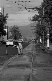
Photograph - Digital image, Peter Bruce, "Cleaning the Points", 1970s
Yields information about the Bridge St landscape looking east.Digital image of a SEC track cleaner at work at the intersection of Sturt and Drummond Streets. Has a tram disappearing into the distance along Sturt St, with Mount Warrenheip in the background. Not the tram poles and tram stops. Photo taken by Peter Bruce 1970's and 1971, prior to the closure of the Ballarat tramway system. Peter's Title of image: "Cleaning the Points"trams, tramways, sturt st, drummond st, track, track cleaner -
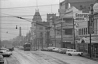 Ballarat Tramway Museum
Photograph - Digital image, 1970s
Yields information about the Lydiard St Nth landscape looking south.Digital image of a bogie tram travelling north in Lydiard St North between Sturt and Mair Sts, with many parked cars. Has the George Hotel, the CBC Bank, Hoyts Regent, and other buildings in the view. Photo taken by Peter Bruce 1970's and 1971, prior to the closure of the Ballarat tramway system. Peter's Title of image: "Gloomy Lydiard St"trams, tramways, lydiard st nth -
 Ballarat Tramway Museum
Photograph - Digital image Set of 3, Peter Bruce, "No. 32 Lydiard St North", 1970s
Yields information about the Lydiard St North Route, and the landscape.Digital image, black and white, set of three images of No. 32 in Lydiard St North, taken with a telephoto lens at various locations. Photo taken by Peter Bruce 1970's and 1971, prior to the closure of the Ballarat tramway system. Peter's Title of image: "No. 32 Lydiard St North"trams, tramways, lydiard st north, tram 32