Showing 565 items matching "lunch"
-
 Eltham District Historical Society Inc
Photograph, Edendale Farm, Eltham Heritage Tour, 24 May 1992, 24/05/1992
ELTHAM HERITAGE TOUR The Society excursion on 24th May 1992 was arranged by David Bick, leader of the team carrying out the Shire's heritage study. David selected a number of sites or buildings identified in the study, some of them lesser known components of the Shire's heritage. The tour commenced at the Eltham Shire Office at 10.00 am. Travel was by private car and mini-bus with stops at about twelve locations for commentary by David. It included a short walk in Hurstbridge and lunch at Kinglake. Highlights of the tour included: - 10 am Leave from Shire Offices - 3 Important Trees - A Physical Link to Eltham's First Settlers - Toorak Mansion Gates - A Surviving Farm House - An Intact Circa 1900 Main Street - First Settlers - Gold Miners, and Timber-getters - An Early Hotel - A Pioneering Homestead - Changing Eltham Shire - 20th Century - 4 pm Afternoon Tea and Finish Tour. Extract from ELTHAM CULTURAL HERITAGE TOUR (Newsletter No. 85, July 1992, by Bettina Woodburn) "The land was unprofitable for intensive farming, but there was always water in the Diamond Creek. The railway, a technological advance, followed the valley, and was provided to transport produce. At North Eltham we were privileged to tour a surviving farmhouse of the 1860-70 era at the Shire’s Edendale Farm, with the as yet unfinished Sculpture for a front fence - bulbous tree-trunks decorated with salt pots, with cross members from the old trestle bridge. As was usual these six veranda posted houses faced South (or East, away from the sun!) with the scullery, kitchen and pantry "out the back". The veranda, which must have been very narrow, no longer exists. It probably wrapped around three sides. The drive took us past the Dutch Windmill, only twenty years old and in the Shire of Diamond Valley, then the Diamond Creek Cemetery with impressive gateway, to a detour to see another old farmhouse, isolated on a hill off Murray Road Wattle Glen. Here was a particularly thick patch of exotic planting of pines and cypresses. Subsistence farming no longer pays. Following the rail-line we noticed on the left near Silvan Road an Edwardian cottage and on the right near Yates Road the old school residence for this Upper Diamond Creek area."Colour photograph1992, culture, edendale, edendale community farm, events -
 Melbourne Tram Museum
Photograph - Last day of original Essendon Airport tram terminus, Ron Scholten, 7-10-1976
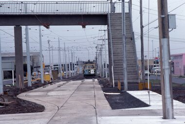
The original line to the Essendon Aerodrome was constructed in 1943 to serve the airport and aircraft construction. It was funded by the Commonwealth Government. By 1976, patronage to the airport terminus in Vaughan St had dropped, the crossing of the highway to the Tullamarine Airport opened in 1970, was dangerous, and the highway needed to be widened. The new terminus was a short distance to the north between Mathews Ave and the Highway. This series of photographs show the last day of operations to the original terminus and the changeover, which was done in about 7 hours. No buses were required. It was done by workers of the Melbourne and Metropolitan Tramways Board. The line was later extended to Airport West. .1 - W5 789, (Essendon Airport Route 59) about to turn from Mathews Ave into Vaughan St. Has new track and footbridge in the foreground. .2 - W5 791 on the siding or spur at the airport terminus, the last tram to use this facility. .3 - W2 571, at the Airport terminus alongside Vaughan St on the last morning of the use of this terminus. The Bundy clock can be seen behind the pole on the lefthand side and the Brick passenger shelter. Shows buffer stops, and Forestair hanger behind. .4 - W2 595 turning from Vaughan St into Mathews Ave. Has the tram stop No. 55 in the view. .5 - W5 839 turning from Vaughan St into Mathews Ave. Shows the flashing yellow light that gave some protection to the trams. .6 - W2 247 about to turn into Vaughan St. Driver about to reboard the tram. Note the new copper trolley wire is up for the new track but has been pulled to the west side using rope. .7 - W5 805, turning from Mathews Ave into Vaughan St, to the old Essendon Airport terminus. Has a new track in the foreground, and the overhead for the curves is still in position. .8 - W6 991 turning from Vaughan St into Matthews Ave, at 855am, the last tram from the old terminus. The track gang has commenced work to remove the outbound curve. Would appear four passengers waiting at the tram stop, two with lunch bags. Note the cattle grid in the foreground between the rails. New rails on the ground on the left-hand side. See Reg Item 6163 for further photos of this event.Yields information about the last day of the operation of the original Essendon Airport tram line.Set of 8 Kodachrome cardboard mount colour slides of the relocation of the Essendon Airport tram terminus 7-10-1976, by Ron Scholten.All slides have detailed descriptions on the reartrams, tramways, essendon aerodrome, essendon airport, closure, new tramways, route 59, w5 789, w5 791, w2 571, w2 595, w5 839, w2 247, w5 805, w6 991, w2 class, w5 class, w6 class, mmtb, trackwork -
 Eltham District Historical Society Inc
Slide - Photograph, Nillumbik Cemetery, 35 Main Street, Diamond Creek, 27 May 1990
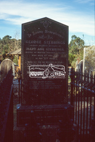
George Stebbing arrived from England in 1857 and settled at Eltham after a short period at Kangaroo Ground. His occupation is often listed as a farmer but he built a number of important buildings between the late 1860’s and the 1880’s. Those remaining include Shillinglaw Cottage, St. Margaret’s Church, Uniting church (formerly Methodist Church) and House at 84 Pitt Street, Eltham. From 1871 to 1875 he was a member of the Eltham Shire Council. Evelyn Observer and Bourke East Record (Vic. : 1902 - 1917), Friday 12 March 1909, page 2 ELTHAM. (FROM OUR OWN CORRESPONDENT.) One of the oldest inhabitants of Eltham passed away during the early hours of Saturday last in the person of Mrs Mary Ann Stebbings. Her residence here covered a period of some-what over 50 years. She had been a widow for some time, her husband, the late Mr. Geo. Stebbings, having pre-deceased her some fourteen or fifteen years. During the later years of her life, she had resided with her niece, Mrs. Wm. Williams. She lived a very retired life and is said to have owned a considerable amount of property, local and suburban, at the time of her death, at the age of 82 years. She was interred at Diamond Creek on Sunday, 7th inst. Local Cemetery Excursion Sunday 27 May 1990 departed Eltham Shire Office at 9.30am and finish mid afternoon. Visits to Eltham , Kangaroo Ground, Queenstown (Smiths Gully), Nillumbik (Diamond Creek), St Katherines (St Helena) Hurst family graves at Hurstbridge and a little known early cemetery at Greensborough. Attended by 20 members. In each case we were introduced to the cemetery with a brief talk. At Eltham, Frank Burgoyne gave us the benefit of his knowledge as a member of the cemetery trust and at Kangaroo Ground, Bruce Ness spoke in a similar capacity. The lunch stop was at Hurstbridge where we visited the Hurst family graves. The President of Nillumbik Historical Society, Jock Ryan, joined us at the Nillumbik (Diamond Creek) cemetery. He travelled on to St Katherines, St Helena, where he talked on the history of the church and cemetery. 35mm colour positive transparency (1 of 23) Mount - Agfachrome Agfa CS System black 8 dotsshire of eltham historical society, cemetery excursion, graves, activities, cemeteries, george stebbing, george stebbings, mary ann stebbing, mary ann stebbings, nillumbik cemetery -
 Eltham District Historical Society Inc
Slide - Photograph, Nillumbik Cemetery, 35 Main Street, Diamond Creek, 27 May 1990
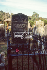
George Stebbing arrived from England in 1857 and settled at Eltham after a short period at Kangaroo Ground. His occupation is often listed as a farmer but he built a number of important buildings between the late 1860’s and the 1880’s. Those remaining include Shillinglaw Cottage, St. Margaret’s Church, Uniting church (formerly Methodist Church) and House at 84 Pitt Street, Eltham. From 1871 to 1875 he was a member of the Eltham Shire Council. Evelyn Observer and Bourke East Record (Vic. : 1902 - 1917), Friday 12 March 1909, page 2 ELTHAM. (FROM OUR OWN CORRESPONDENT.) One of the oldest inhabitants of Eltham passed away during the early hours of Saturday last in the person of Mrs Mary Ann Stebbings. Her residence here covered a period of some-what over 50 years. She had been a widow for some time, her husband, the late Mr. Geo. Stebbings, having pre-deceased her some fourteen or fifteen years. During the later years of her life, she had resided with her niece, Mrs. Wm. Williams. She lived a very retired life and is said to have owned a considerable amount of property, local and suburban, at the time of her death, at the age of 82 years. She was interred at Diamond Creek on Sunday, 7th inst. Local Cemetery Excursion Sunday 27 May 1990 departed Eltham Shire Office at 9.30am and finish mid afternoon. Visits to Eltham , Kangaroo Ground, Queenstown (Smiths Gully), Nillumbik (Diamond Creek), St Katherines (St Helena) Hurst family graves at Hurstbridge and a little known early cemetery at Greensborough. Attended by 20 members. In each case we were introduced to the cemetery with a brief talk. At Eltham, Frank Burgoyne gave us the benefit of his knowledge as a member of the cemetery trust and at Kangaroo Ground, Bruce Ness spoke in a similar capacity. The lunch stop was at Hurstbridge where we visited the Hurst family graves. The President of Nillumbik Historical Society, Jock Ryan, joined us at the Nillumbik (Diamond Creek) cemetery. He travelled on to St Katherines, St Helena, where he talked on the history of the church and cemetery. 35mm colour positive transparency (1 of 23) Mount - Agfachrome Agfa CS System black 8 dotsshire of eltham historical society, cemetery excursion, graves, activities, cemeteries, george stebbing, george stebbings, mary ann stebbing, mary ann stebbings, nillumbik cemetery -
 Flagstaff Hill Maritime Museum and Village
Instrument - Clock Parts, Bef. 01-06-1878
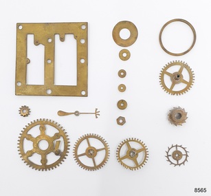
The clock parts were discovered in 1980 by Julie Wilkins, a Victorian scuba diver who had already experienced more than 500 dives in Australia and overseas. She was holidaying in Peterborough, Victoria, and looking forward to discovering more about the famous Loch Ard ship, wrecked in June 1878 at Mutton Bird Island. The fast Glasgow-built clipper ship was only five years old when the tragedy occurred. There were 54 people on board the vessel and only two survived Julie's holiday photograph of Boat Bay reminds her of her most memorable dive. Submerged in the calm, flat sea, she was carefully scanning around the remains of the old wreck when, to her amazement, a gold coin and a small gold cross suddenly came up towards her. She excitedly cupped them in her hands and then stowed the treasures safely in her wetsuit and continued her dive. She soon discovered a group of brass carriage clock parts and some bottles of champagne. It was a day full of surprises. The items were easily recognisable, without any build-up of encrustations or concretion. Julie secretly enjoyed her treasures for twenty-four years then packed them up for the early morning train trip to Warrnambool. After a short walk to Flagstaff Hill Maritime Museum and Village, her photograph was taken as she handed over her precious find. She told her story to a local newspaper reporter, lunched a café in town then took the late afternoon train home. Her generous donation is now part of a vast collection of Loch Ard shipwreck artefacts, including the gold watch and the Minton Majolica model peacock. This group of brass clockwork parts is incomplete. The pieces were in the ocean for over 100 years before Julie recovered them from the Loch Ard wreck. Their size would suit the works of a carriage clock, with a mainspring and weight to power the clock movement, a pendulum to measure the clock's speed, arbours, posts, pillars and at least one other plate. They would have been mounted inside a protective case with a small door to easily access the clock face for setting the time and accessing the key's winding hole. The clock cases were usually made from decorative gilt brass with a glass front and a carrying handle. The parts include a weighted second hand with a decorative four-pronged finish at one end, a rounded weight at the other, and a hole for attaching it to the clock face. The gear teeth profiles are ‘cycloidal’, an arch shape with vertical sides, which is common for antique clocks. Modern clockworks have ‘involute’ teeth with sloping sides and a squared-off top. The brass carriage clock parts are an example of a mechanical clock produced in the 1870s. The clock's design is a part of the chain of technological improvements in methods for timekeeping. Its cycloidal gear teeth were the forerunner of the more modern involute gears. The group of clock parts includes a weighted hand or arm for signifying the seconds. This feature was uncommon in portable Victorian-era clocks. The clock parts are also significant for their association with the ill-fated sailing ship Loch Ard, wrecked in 1878. The travelling clock or officer’s clock may have been part of the cargo destined for the 1880 Melbourne Exhibition, or the personal possession of one of the people on board the vessel. Brass clockwork parts from a mechanical clock, sixteen pieces. Parts comprise a plate, large gears or wheels, small pinions or wheels with fine teeth, wheels with cogs, and a weighted second hand. The parts were from a carriage clock ca. 1878. They were recovered from the wreck of the sailing ship Loch Ard.flagstaff hill maritime museum and village, warrnambool, great ocean road, shipwreck coast, loch ard, wreck of the loch ard, 1878, mutton bird island, peterborough, scuba diver, 1980s, shipwreck artefact, relic, clock, mechanical, clock parts, time, timekeeper, horology, chronometry, cogs, time keeping device, scientific instrument, chronometer, john harrison, longitude, carriage clock, coach clock, portable clock, travelling clock, travel clock, traveller’s clock, officer’s clock, weighted second hand, victorian era, cycloidal gear teeth, brass clock, julie wilkins -
 Eltham District Historical Society Inc
Photograph, Shire of Eltham War Memorial, Memorial Park, Garden Hill, Kangaroo Ground; Eltham Heritage Tour, 24 May 1992, 24/05/1992
ELTHAM HERITAGE TOUR The Society excursion on 24th May 1992 was arranged by David Bick, leader of the team carrying out the Shire's heritage study. David selected a number of sites or buildings identified in the study, some of them lesser known components of the Shire's heritage. The tour commenced at the Eltham Shire Office at 10.00 am. Travel was by private car and mini-bus with stops at about twelve locations for commentary by David.It included a short walk in Hurstbridge and lunch at Kinglake. Highlights of the tour included: - 10 am Leave from Shire Offices - 3 Important Trees - A Physical Link to Eltham's First Settlers - Toorak Mansion Gates - A Surviving Farm House - An Intact Circa 1900 Main Street - First Settlers - Gold Miners, and Timber-getters - An Early Hotel - A Pioneering Homestead - Changing Eltham Shire - 20th Century - 4 pm Afternoon Tea and Finish Tour Extract from ELTHAM CULTURAL HERITAGE TOUR (Newsletter No. 85, July 1992, by Bettina Woodburn) "Now we drove through stands of pines to the Kangaroo Ground Lookout Tower, a most unusual War Memorial, World War I. The tower and a shed/residence (it had a chimney) were built from local sandstone. Below to the south and east of Melbourne spread 'suburbia'. Close by the landscape seemed so contrived - English fields and hedgerows! Although only about twenty inches deep, the soil of this ancient volcano, its crater lost under subsequent weathering, was rich, deserving the name of "Garden Hill". Now native trees are taking over again. In Kangaroo Ground itself stand the inevitable Store, School and Church - and two Norfolk pines and a monkey puzzle tree." On November 11th 1926 the Shire of Eltham War Memorial Tower at Kangaroo Ground was opened. It is regarded as one of Melbourne’s most outstanding lookout towers. It commands a magnificent 360 degree panorama from Kinglake across the Diamond Valley to Macedon and the You Yangs. It is built on a peak which was once a volcano, 237 metres above sea level. After World War one a memorial cairn was erected on the site, and in 1925 a committee of public-minded citizens began to plan for a tower. Many generous donations of material and money were forthcoming so that in 1926 the Governor General Lord Stonehaven was able to unveil the plaque before a crowd of 500 people. There was some concern in the 1960s when the Forests Commission wanted to build a firespotters cabin on the top. At first R.S.L. branches opposed the idea, but it was realised that this use could combine with its use as a tourist attraction, and would ensure its maintenance for the future, Today the Kangaroo Ground tower provides one of the best views around Melbourne and is a fitting memorial to those who died in two world wars. From: Historic items for Diamond Valley Community Radio September 1990 (EDHS collection) Record of the Society's history and activities and highlighting various aspects of the Heritage Study undertaken by David Bick used to create the future heritage overlay for the Shire of Eltham and later Nillumbik Shire.Roll of 35mm colour negative film, 4 stripsKodak Gold 100 5095culture, events, garden hill, kangaroo ground, kangaroo ground memorial, memorial park, shire of eltham war memorial tower, war memorials -
 Eltham District Historical Society Inc
Photograph, Murchison Gap, Autumn Excursion, Hume and Hovell's 1824 expedition, 26 May 1996, 26/05/1996
[article by Bettina Woodburn in EDHS Newsletter No. 109, July 1996:] ON THE TRAIL OF HUME AND HOVELL - REPORT ON THE AUTUMN EXCURSION - On a green and fresh morning (Sunday 26th May 1996) the Cobb and Co coach (driven by the most obliging Peter Tampion) set off in a north easterly direction from Eltham to connect with Hume and Hovell's route on their 1824 explorations of central Victoria. The Society would follow a series of monuments erected for the 1924 centenary of the expedition from King Parrot Creek (Tuesday 7th December 1824), through Strath Creek, over Sunday Creek (Sunday 12th December 1824) at Broadford, Tullamarine, St Albans, Deer Park, through Werribee, skirting east of the You Yangs to Lara and Avalon Beach. Because their distance-measuring wheel had broken and a one degree mistake was made in calculations, the two leaders of the original group of six convict-companions arrived at Corio Bay, instead of the expected Western Port, discovered earlier by Flinders. From below Mt. Disappointment (Hume and Hovell's difficulties in "scrambling over brush and rock", "leeches in forest, as well as no water", "cutting grass 4-5 ft. high", dreadful scrub", "devil flies") we took an easier route, saw the Strath Creek memorial in ground fog and a wonderful "field of dreams", the Hume-Hovell privately owned cricket ground with its white picket boundary fence. Now, after a steep climb, in sunshine under gums we stretched and viewed magnificent rolling hills and fog-filled valleys - not "smoke from Aborigines' bush fires". After morning tea at Broadford we followed the Sunday Creek valley beside the Hume Freeway, passed the Wallan Wallan Rest Area (more appropriately Hume and Hovell Rest Area) to tum right at Beveridge. In Gellibrand Hill Park, near the headwaters of the Moonee Ponds Creek, we experienced the landscape the first European settlers saw - huge river red gums and rolling pastures. The gardens and sheltered courtyard of the 1840s, timber, brought from .....[?] prefabricated Woodlands Homestead, provided a pleasant lunch stop. We enjoyed a private tour, panoramic views over Melbourne and surroundings and the excitement of arriving and departing aircraft. Our next river crossing was at Werribee, "in a vast treeless plain", then we drove on by-ways no coach had previously travelled, to find "an immense sheet of water" salty Corio Bay, off-course to the west. In late afternoon of a super, calm, late autumn day we headed homewards. Back at Eltham we were rather surprised to find that we had travelled a total of 347 km. Thanks again to Russell Yeoman for his research and organization. What a wonderful day! Three colour photographsactivities, murchison gap, murchison valley -
 Eltham District Historical Society Inc
Photograph, Hume and Hovell Monument, Broadford, Autumn Excursion, Hume and Hovell's 1824 expedition, 26 May 1996, 26/05/1996
[article by Bettina Woodburn in EDHS Newsletter No. 109, July 1996:] ON THE TRAIL OF HUME AND HOVELL - REPORT ON THE AUTUMN EXCURSION - On a green and fresh morning (Sunday 26th May 1996) the Cobb and Co coach (driven by the most obliging Peter Tampion) set off in a north easterly direction from Eltham to connect with Hume and Hovell's route on their 1824 explorations of central Victoria. The Society would follow a series of monuments erected for the 1924 centenary of the expedition from King Parrot Creek (Tuesday 7th December 1824), through Strath Creek, over Sunday Creek (Sunday 12th December 1824) at Broadford, Tullamarine, St Albans, Deer Park, through Werribee, skirting east of the You Yangs to Lara and Avalon Beach. Because their distance-measuring wheel had broken and a one degree mistake was made in calculations, the two leaders of the original group of six convict-companions arrived at Corio Bay, instead of the expected Western Port, discovered earlier by Flinders. From below Mt. Disappointment (Hume and Hovell's difficulties in "scrambling over brush and rock", "leeches in forest, as well as no water", "cutting grass 4-5 ft. high", dreadful scrub", "devil flies") we took an easier route, saw the Strath Creek memorial in ground fog and a wonderful "field of dreams", the Hume-Hovell privately owned cricket ground with its white picket boundary fence. Now, after a steep climb, in sunshine under gums we stretched and viewed magnificent rolling hills and fog-filled valleys - not "smoke from Aborigines' bush fires". After morning tea at Broadford we followed the Sunday Creek valley beside the Hume Freeway, passed the Wallan Wallan Rest Area (more appropriately Hume and Hovell Rest Area) to tum right at Beveridge. In Gellibrand Hill Park, near the headwaters of the Moonee Ponds Creek, we experienced the landscape the first European settlers saw - huge river red gums and rolling pastures. The gardens and sheltered courtyard of the 1840s, timber, brought from .....[?] prefabricated Woodlands Homestead, provided a pleasant lunch stop. We enjoyed a private tour, panoramic views over Melbourne and surroundings and the excitement of arriving and departing aircraft. Our next river crossing was at Werribee, "in a vast treeless plain", then we drove on by-ways no coach had previously travelled, to find "an immense sheet of water" salty Corio Bay, off-course to the west. In late afternoon of a super, calm, late autumn day we headed homewards. Back at Eltham we were rather surprised to find that we had travelled a total of 347 km. Thanks again to Russell Yeoman for his research and organization. What a wonderful day! Colour photographactivities, broadford, hume and hovell, monument -
 Eltham District Historical Society Inc
Photograph, Hume and Hovell Monument, Autumn Excursion, Hume and Hovell's 1824 expedition, 26 May 1996, 26/05/1996
[article by Bettina Woodburn in EDHS Newsletter No. 109, July 1996:] ON THE TRAIL OF HUME AND HOVELL - REPORT ON THE AUTUMN EXCURSION - On a green and fresh morning (Sunday 26th May 1996) the Cobb and Co coach (driven by the most obliging Peter Tampion) set off in a north easterly direction from Eltham to connect with Hume and Hovell's route on their 1824 explorations of central Victoria. The Society would follow a series of monuments erected for the 1924 centenary of the expedition from King Parrot Creek (Tuesday 7th December 1824), through Strath Creek, over Sunday Creek (Sunday 12th December 1824) at Broadford, Tullamarine, St Albans, Deer Park, through Werribee, skirting east of the You Yangs to Lara and Avalon Beach. Because their distance-measuring wheel had broken and a one degree mistake was made in calculations, the two leaders of the original group of six convict-companions arrived at Corio Bay, instead of the expected Western Port, discovered earlier by Flinders. From below Mt. Disappointment (Hume and Hovell's difficulties in "scrambling over brush and rock", "leeches in forest, as well as no water", "cutting grass 4-5 ft. high", dreadful scrub", "devil flies") we took an easier route, saw the Strath Creek memorial in ground fog and a wonderful "field of dreams", the Hume-Hovell privately owned cricket ground with its white picket boundary fence. Now, after a steep climb, in sunshine under gums we stretched and viewed magnificent rolling hills and fog-filled valleys - not "smoke from Aborigines' bush fires". After morning tea at Broadford we followed the Sunday Creek valley beside the Hume Freeway, passed the Wallan Wallan Rest Area (more appropriately Hume and Hovell Rest Area) to tum right at Beveridge. In Gellibrand Hill Park, near the headwaters of the Moonee Ponds Creek, we experienced the landscape the first European settlers saw - huge river red gums and rolling pastures. The gardens and sheltered courtyard of the 1840s, timber, brought from .....[?] prefabricated Woodlands Homestead, provided a pleasant lunch stop. We enjoyed a private tour, panoramic views over Melbourne and surroundings and the excitement of arriving and departing aircraft. Our next river crossing was at Werribee, "in a vast treeless plain", then we drove on by-ways no coach had previously travelled, to find "an immense sheet of water" salty Corio Bay, off-course to the west. In late afternoon of a super, calm, late autumn day we headed homewards. Back at Eltham we were rather surprised to find that we had travelled a total of 347 km. Thanks again to Russell Yeoman for his research and organization. What a wonderful day! Two colour photographsactivities, hume and hovell, monument -
 Eltham District Historical Society Inc
Photograph, Hume and Hovell Monument, Broadford, Autumn Excursion, Hume and Hovell's 1824 expedition, 26 May 1996, 26/05/1996
[article by Bettina Woodburn in EDHS Newsletter No. 109, July 1996:] ON THE TRAIL OF HUME AND HOVELL - REPORT ON THE AUTUMN EXCURSION - On a green and fresh morning (Sunday 26th May 1996) the Cobb and Co coach (driven by the most obliging Peter Tampion) set off in a north easterly direction from Eltham to connect with Hume and Hovell's route on their 1824 explorations of central Victoria. The Society would follow a series of monuments erected for the 1924 centenary of the expedition from King Parrot Creek (Tuesday 7th December 1824), through Strath Creek, over Sunday Creek (Sunday 12th December 1824) at Broadford, Tullamarine, St Albans, Deer Park, through Werribee, skirting east of the You Yangs to Lara and Avalon Beach. Because their distance-measuring wheel had broken and a one degree mistake was made in calculations, the two leaders of the original group of six convict-companions arrived at Corio Bay, instead of the expected Western Port, discovered earlier by Flinders. From below Mt. Disappointment (Hume and Hovell's difficulties in "scrambling over brush and rock", "leeches in forest, as well as no water", "cutting grass 4-5 ft. high", dreadful scrub", "devil flies") we took an easier route, saw the Strath Creek memorial in ground fog and a wonderful "field of dreams", the Hume-Hovell privately owned cricket ground with its white picket boundary fence. Now, after a steep climb, in sunshine under gums we stretched and viewed magnificent rolling hills and fog-filled valleys - not "smoke from Aborigines' bush fires". After morning tea at Broadford we followed the Sunday Creek valley beside the Hume Freeway, passed the Wallan Wallan Rest Area (more appropriately Hume and Hovell Rest Area) to tum right at Beveridge. In Gellibrand Hill Park, near the headwaters of the Moonee Ponds Creek, we experienced the landscape the first European settlers saw - huge river red gums and rolling pastures. The gardens and sheltered courtyard of the 1840s, timber, brought from .....[?] prefabricated Woodlands Homestead, provided a pleasant lunch stop. We enjoyed a private tour, panoramic views over Melbourne and surroundings and the excitement of arriving and departing aircraft. Our next river crossing was at Werribee, "in a vast treeless plain", then we drove on by-ways no coach had previously travelled, to find "an immense sheet of water" salty Corio Bay, off-course to the west. In late afternoon of a super, calm, late autumn day we headed homewards. Back at Eltham we were rather surprised to find that we had travelled a total of 347 km. Thanks again to Russell Yeoman for his research and organization. What a wonderful day! Colour photographactivities, broadford, hume and hovell, monument -
 Eltham District Historical Society Inc
Photograph, Strath Creek, Autumn Excursion, Hume and Hovell's 1824 expedition, 26 May 1996, 26/05/1996
[article by Bettina Woodburn in EDHS Newsletter No. 109, July 1996:] ON THE TRAIL OF HUME AND HOVELL - REPORT ON THE AUTUMN EXCURSION - On a green and fresh morning (Sunday 26th May 1996) the Cobb and Co coach (driven by the most obliging Peter Tampion) set off in a north easterly direction from Eltham to connect with Hume and Hovell's route on their 1824 explorations of central Victoria. The Society would follow a series of monuments erected for the 1924 centenary of the expedition from King Parrot Creek (Tuesday 7th December 1824), through Strath Creek, over Sunday Creek (Sunday 12th December 1824) at Broadford, Tullamarine, St Albans, Deer Park, through Werribee, skirting east of the You Yangs to Lara and Avalon Beach. Because their distance-measuring wheel had broken and a one degree mistake was made in calculations, the two leaders of the original group of six convict-companions arrived at Corio Bay, instead of the expected Western Port, discovered earlier by Flinders. From below Mt. Disappointment (Hume and Hovell's difficulties in "scrambling over brush and rock", "leeches in forest, as well as no water", "cutting grass 4-5 ft. high", dreadful scrub", "devil flies") we took an easier route, saw the Strath Creek memorial in ground fog and a wonderful "field of dreams", the Hume-Hovell privately owned cricket ground with its white picket boundary fence. Now, after a steep climb, in sunshine under gums we stretched and viewed magnificent rolling hills and fog-filled valleys - not "smoke from Aborigines' bush fires". After morning tea at Broadford we followed the Sunday Creek valley beside the Hume Freeway, passed the Wallan Wallan Rest Area (more appropriately Hume and Hovell Rest Area) to tum right at Beveridge. In Gellibrand Hill Park, near the headwaters of the Moonee Ponds Creek, we experienced the landscape the first European settlers saw - huge river red gums and rolling pastures. The gardens and sheltered courtyard of the 1840s, timber, brought from .....[?] prefabricated Woodlands Homestead, provided a pleasant lunch stop. We enjoyed a private tour, panoramic views over Melbourne and surroundings and the excitement of arriving and departing aircraft. Our next river crossing was at Werribee, "in a vast treeless plain", then we drove on by-ways no coach had previously travelled, to find "an immense sheet of water" salty Corio Bay, off-course to the west. In late afternoon of a super, calm, late autumn day we headed homewards. Back at Eltham we were rather surprised to find that we had travelled a total of 347 km. Thanks again to Russell Yeoman for his research and organization. What a wonderful day! Colour photographactivities, monument, hume and hovell, murchison valley, strath creek -
 Eltham District Historical Society Inc
Photograph, Murchison Gap viewed from Strath Creek, Autumn Excursion, Hume and Hovell's 1824 expedition, 26 May 1996, 26/05/1996
[article by Bettina Woodburn in EDHS Newsletter No. 109, July 1996:] ON THE TRAIL OF HUME AND HOVELL - REPORT ON THE AUTUMN EXCURSION - On a green and fresh morning (Sunday 26th May 1996) the Cobb and Co coach (driven by the most obliging Peter Tampion) set off in a north easterly direction from Eltham to connect with Hume and Hovell's route on their 1824 explorations of central Victoria. The Society would follow a series of monuments erected for the 1924 centenary of the expedition from King Parrot Creek (Tuesday 7th December 1824), through Strath Creek, over Sunday Creek (Sunday 12th December 1824) at Broadford, Tullamarine, St Albans, Deer Park, through Werribee, skirting east of the You Yangs to Lara and Avalon Beach. Because their distance-measuring wheel had broken and a one degree mistake was made in calculations, the two leaders of the original group of six convict-companions arrived at Corio Bay, instead of the expected Western Port, discovered earlier by Flinders. From below Mt. Disappointment (Hume and Hovell's difficulties in "scrambling over brush and rock", "leeches in forest, as well as no water", "cutting grass 4-5 ft. high", dreadful scrub", "devil flies") we took an easier route, saw the Strath Creek memorial in ground fog and a wonderful "field of dreams", the Hume-Hovell privately owned cricket ground with its white picket boundary fence. Now, after a steep climb, in sunshine under gums we stretched and viewed magnificent rolling hills and fog-filled valleys - not "smoke from Aborigines' bush fires". After morning tea at Broadford we followed the Sunday Creek valley beside the Hume Freeway, passed the Wallan Wallan Rest Area (more appropriately Hume and Hovell Rest Area) to tum right at Beveridge. In Gellibrand Hill Park, near the headwaters of the Moonee Ponds Creek, we experienced the landscape the first European settlers saw - huge river red gums and rolling pastures. The gardens and sheltered courtyard of the 1840s, timber, brought from .....[?] prefabricated Woodlands Homestead, provided a pleasant lunch stop. We enjoyed a private tour, panoramic views over Melbourne and surroundings and the excitement of arriving and departing aircraft. Our next river crossing was at Werribee, "in a vast treeless plain", then we drove on by-ways no coach had previously travelled, to find "an immense sheet of water" salty Corio Bay, off-course to the west. In late afternoon of a super, calm, late autumn day we headed homewards. Back at Eltham we were rather surprised to find that we had travelled a total of 347 km. Thanks again to Russell Yeoman for his research and organization. What a wonderful day! Colour photographactivities, hume and hovell, murchison valley, murchison gap, strath creek -
 Eltham District Historical Society Inc
Photograph, Autumn Excursion, Hume and Hovell's 1824 expedition, 26 May 1996, 26/05/1996
[article by Bettina Woodburn in EDHS Newsletter No. 109, July 1996:] ON THE TRAIL OF HUME AND HOVELL - REPORT ON THE AUTUMN EXCURSION - On a green and fresh morning (Sunday 26th May 1996) the Cobb and Co coach (driven by the most obliging Peter Tampion) set off in a north easterly direction from Eltham to connect with Hume and Hovell's route on their 1824 explorations of central Victoria. The Society would follow a series of monuments erected for the 1924 centenary of the expedition from King Parrot Creek (Tuesday 7th December 1824), through Strath Creek, over Sunday Creek (Sunday 12th December 1824) at Broadford, Tullamarine, St Albans, Deer Park, through Werribee, skirting east of the You Yangs to Lara and Avalon Beach. Because their distance-measuring wheel had broken and a one degree mistake was made in calculations, the two leaders of the original group of six convict-companions arrived at Corio Bay, instead of the expected Western Port, discovered earlier by Flinders. From below Mt. Disappointment (Hume and Hovell's difficulties in "scrambling over brush and rock", "leeches in forest, as well as no water", "cutting grass 4-5 ft. high", dreadful scrub", "devil flies") we took an easier route, saw the Strath Creek memorial in ground fog and a wonderful "field of dreams", the Hume-Hovell privately owned cricket ground with its white picket boundary fence. Now, after a steep climb, in sunshine under gums we stretched and viewed magnificent rolling hills and fog-filled valleys - not "smoke from Aborigines' bush fires". After morning tea at Broadford we followed the Sunday Creek valley beside the Hume Freeway, passed the Wallan Wallan Rest Area (more appropriately Hume and Hovell Rest Area) to tum right at Beveridge. In Gellibrand Hill Park, near the headwaters of the Moonee Ponds Creek, we experienced the landscape the first European settlers saw - huge river red gums and rolling pastures. The gardens and sheltered courtyard of the 1840s, timber, brought from .....[?] prefabricated Woodlands Homestead, provided a pleasant lunch stop. We enjoyed a private tour, panoramic views over Melbourne and surroundings and the excitement of arriving and departing aircraft. Our next river crossing was at Werribee, "in a vast treeless plain", then we drove on by-ways no coach had previously travelled, to find "an immense sheet of water" salty Corio Bay, off-course to the west. In late afternoon of a super, calm, late autumn day we headed homewards. Back at Eltham we were rather surprised to find that we had travelled a total of 347 km. Thanks again to Russell Yeoman for his research and organization. What a wonderful day! Colour photographactivities, hume and hovell -
 Eltham District Historical Society Inc
Photograph, Sign to Hume and Hovell Cricket Ground, at Allandale Road, Strath Creek, Autumn Excursion, Hume and Hovell's 1824 expedition, 26 May 1996, 26/05/1996
[article by Bettina Woodburn in EDHS Newsletter No. 109, July 1996:] ON THE TRAIL OF HUME AND HOVELL - REPORT ON THE AUTUMN EXCURSION - On a green and fresh morning (Sunday 26th May 1996) the Cobb and Co coach (driven by the most obliging Peter Tampion) set off in a north easterly direction from Eltham to connect with Hume and Hovell's route on their 1824 explorations of central Victoria. The Society would follow a series of monuments erected for the 1924 centenary of the expedition from King Parrot Creek (Tuesday 7th December 1824), through Strath Creek, over Sunday Creek (Sunday 12th December 1824) at Broadford, Tullamarine, St Albans, Deer Park, through Werribee, skirting east of the You Yangs to Lara and Avalon Beach. Because their distance-measuring wheel had broken and a one degree mistake was made in calculations, the two leaders of the original group of six convict-companions arrived at Corio Bay, instead of the expected Western Port, discovered earlier by Flinders. From below Mt. Disappointment (Hume and Hovell's difficulties in "scrambling over brush and rock", "leeches in forest, as well as no water", "cutting grass 4-5 ft. high", dreadful scrub", "devil flies") we took an easier route, saw the Strath Creek memorial in ground fog and a wonderful "field of dreams", the Hume-Hovell privately owned cricket ground with its white picket boundary fence. Now, after a steep climb, in sunshine under gums we stretched and viewed magnificent rolling hills and fog-filled valleys - not "smoke from Aborigines' bush fires". After morning tea at Broadford we followed the Sunday Creek valley beside the Hume Freeway, passed the Wallan Wallan Rest Area (more appropriately Hume and Hovell Rest Area) to tum right at Beveridge. In Gellibrand Hill Park, near the headwaters of the Moonee Ponds Creek, we experienced the landscape the first European settlers saw - huge river red gums and rolling pastures. The gardens and sheltered courtyard of the 1840s, timber, brought from .....[?] prefabricated Woodlands Homestead, provided a pleasant lunch stop. We enjoyed a private tour, panoramic views over Melbourne and surroundings and the excitement of arriving and departing aircraft. Our next river crossing was at Werribee, "in a vast treeless plain", then we drove on by-ways no coach had previously travelled, to find "an immense sheet of water" salty Corio Bay, off-course to the west. In late afternoon of a super, calm, late autumn day we headed homewards. Back at Eltham we were rather surprised to find that we had travelled a total of 347 km. Thanks again to Russell Yeoman for his research and organization. What a wonderful day! Colour photographactivities, hume and hovell, allandale road, strath creek -
 Eltham District Historical Society Inc
Photograph, Autumn Excursion, Hume and Hovell's 1824 expedition, 26 May 1996, 26/05/1996
[article by Bettina Woodburn in EDHS Newsletter No. 109, July 1996:] ON THE TRAIL OF HUME AND HOVELL - REPORT ON THE AUTUMN EXCURSION - On a green and fresh morning (Sunday 26th May 1996) the Cobb and Co coach (driven by the most obliging Peter Tampion) set off in a north easterly direction from Eltham to connect with Hume and Hovell's route on their 1824 explorations of central Victoria. The Society would follow a series of monuments erected for the 1924 centenary of the expedition from King Parrot Creek (Tuesday 7th December 1824), through Strath Creek, over Sunday Creek (Sunday 12th December 1824) at Broadford, Tullamarine, St Albans, Deer Park, through Werribee, skirting east of the You Yangs to Lara and Avalon Beach. Because their distance-measuring wheel had broken and a one degree mistake was made in calculations, the two leaders of the original group of six convict-companions arrived at Corio Bay, instead of the expected Western Port, discovered earlier by Flinders. From below Mt. Disappointment (Hume and Hovell's difficulties in "scrambling over brush and rock", "leeches in forest, as well as no water", "cutting grass 4-5 ft. high", dreadful scrub", "devil flies") we took an easier route, saw the Strath Creek memorial in ground fog and a wonderful "field of dreams", the Hume-Hovell privately owned cricket ground with its white picket boundary fence. Now, after a steep climb, in sunshine under gums we stretched and viewed magnificent rolling hills and fog-filled valleys - not "smoke from Aborigines' bush fires". After morning tea at Broadford we followed the Sunday Creek valley beside the Hume Freeway, passed the Wallan Wallan Rest Area (more appropriately Hume and Hovell Rest Area) to tum right at Beveridge. In Gellibrand Hill Park, near the headwaters of the Moonee Ponds Creek, we experienced the landscape the first European settlers saw - huge river red gums and rolling pastures. The gardens and sheltered courtyard of the 1840s, timber, brought from .....[?] prefabricated Woodlands Homestead, provided a pleasant lunch stop. We enjoyed a private tour, panoramic views over Melbourne and surroundings and the excitement of arriving and departing aircraft. Our next river crossing was at Werribee, "in a vast treeless plain", then we drove on by-ways no coach had previously travelled, to find "an immense sheet of water" salty Corio Bay, off-course to the west. In late afternoon of a super, calm, late autumn day we headed homewards. Back at Eltham we were rather surprised to find that we had travelled a total of 347 km. Thanks again to Russell Yeoman for his research and organization. What a wonderful day! Colour photographactivities, hume and hovell -
 Eltham District Historical Society Inc
Photograph, Autumn Excursion, Hume and Hovell's 1824 expedition, 26 May 1996, 26/05/1996
[article by Bettina Woodburn in EDHS Newsletter No. 109, July 1996:] ON THE TRAIL OF HUME AND HOVELL - REPORT ON THE AUTUMN EXCURSION - On a green and fresh morning (Sunday 26th May 1996) the Cobb and Co coach (driven by the most obliging Peter Tampion) set off in a north easterly direction from Eltham to connect with Hume and Hovell's route on their 1824 explorations of central Victoria. The Society would follow a series of monuments erected for the 1924 centenary of the expedition from King Parrot Creek (Tuesday 7th December 1824), through Strath Creek, over Sunday Creek (Sunday 12th December 1824) at Broadford, Tullamarine, St Albans, Deer Park, through Werribee, skirting east of the You Yangs to Lara and Avalon Beach. Because their distance-measuring wheel had broken and a one degree mistake was made in calculations, the two leaders of the original group of six convict-companions arrived at Corio Bay, instead of the expected Western Port, discovered earlier by Flinders. From below Mt. Disappointment (Hume and Hovell's difficulties in "scrambling over brush and rock", "leeches in forest, as well as no water", "cutting grass 4-5 ft. high", dreadful scrub", "devil flies") we took an easier route, saw the Strath Creek memorial in ground fog and a wonderful "field of dreams", the Hume-Hovell privately owned cricket ground with its white picket boundary fence. Now, after a steep climb, in sunshine under gums we stretched and viewed magnificent rolling hills and fog-filled valleys - not "smoke from Aborigines' bush fires". After morning tea at Broadford we followed the Sunday Creek valley beside the Hume Freeway, passed the Wallan Wallan Rest Area (more appropriately Hume and Hovell Rest Area) to tum right at Beveridge. In Gellibrand Hill Park, near the headwaters of the Moonee Ponds Creek, we experienced the landscape the first European settlers saw - huge river red gums and rolling pastures. The gardens and sheltered courtyard of the 1840s, timber, brought from .....[?] prefabricated Woodlands Homestead, provided a pleasant lunch stop. We enjoyed a private tour, panoramic views over Melbourne and surroundings and the excitement of arriving and departing aircraft. Our next river crossing was at Werribee, "in a vast treeless plain", then we drove on by-ways no coach had previously travelled, to find "an immense sheet of water" salty Corio Bay, off-course to the west. In late afternoon of a super, calm, late autumn day we headed homewards. Back at Eltham we were rather surprised to find that we had travelled a total of 347 km. Thanks again to Russell Yeoman for his research and organization. What a wonderful day! Colour photographactivities, hume and hovell -
 Flagstaff Hill Maritime Museum and Village
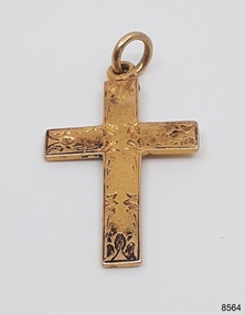
Accessory - Gold Cross, Bef. 01-06-1878
The gold cross was discovered by Victorian scuba diver Julie Wilkins, who had already experienced more than 500 dives in Australia and overseas. She was holidaying in Peterborough, Victoria, and looking forward to discovering more about the famous Loch Ard ship, wrecked in June 1878 at Mutton Bird Island. The fast Glasgow-built clipper ship was only five years old when the tragedy occurred. There were 54 people on board the vessel and only two survived Julie's holiday photograph of Boat Bay reminds her of her most memorable dive. Submerged in the calm, flat sea, she was carefully scanning around the remains of the old wreck when, to her amazement, a gold coin and a small gold cross suddenly came up towards her. She excitedly cupped them in her hands, then stowed the treasures safely in her wetsuit and continued her dive. She soon discovered a group of brass carriage clock parts and some bottles of champagne. It was a day full of surprises. The items were easily recognisable, without any build-up of encrustations or concretion. Julie secretly enjoyed her treasures for twenty-four years then packed them up for the early morning train trip to Warrnambool. After a short walk to Flagstaff Hill Maritime Museum and Village, her photograph was taken as she handed over her precious find. She told her story to a local newspaper reporter, lunched a café in town then took the late afternoon train home. Her generous donation is now part of a vast collection of Loch Ard shipwreck artefacts, including the gold watch and the Minton Majolica model peacock. The small decorative cross dates back to on or before 1878, when the Loch Ard had set sail. The loop and ring have been added, perhaps as a pendant, pocket watch accessory or similar purpose. It may have been worn for ‘good luck’ or a ‘blessing’ on the long journey to Australia, where ships had to carefully navigate the treacherous Bass’s Strait before arriving at their destination of Melbourne. Sadly, many met their fate on that short stretch of ocean aptly named the Shipwreck Coast. The cross is very recognisable even though it was exposed to the wrecking of the ship, its consequent movement, and the sea's turbulence. Its scratched, pitted and worn condition, and the damage near the loop, is part of its story. The red-brown-black discolouration is similar to that found on other gold coins, sometimes called the ‘corrosion phenomena’. Studies suggest the possible cause is contaminants in the minting process reacting to the coins’ environment. Three edges of the cross have slightly raised narrow ridges of gold which could have been cause by the gold being cast liquid gold into a mould.This gold cross pendant is significant as a symbol of Christianity, a sign of hope and safety, and a sample of the religious following on board the Loch Ard, although not everyone wears a cross for this reason. This cross is a sample of jewellery owned by people migrating to Australia in the late 19th century. The cross and the guinea recovered together from the wreck of the Loch Ard are made of gold and help interpret the financial status of some of those on board.Gold cross; yellow gold with decorative hand engraved foliage design on the front, fitted loop and ring on top. The simple Latin or Roman variation of the cross, with an elongated vertical arm, has no figure on it and the reverse has no decoration. The right, left and base edges have sections of narrow, long slightly raised ridges. The top edge has remnants of red-black colour. Victorian era cross, ca. 1878. The cross was recovered from the wreck of the ship Loch Ard.Engraved foliage design. Slightly raised long ridges on sides and base edges. flagstaff hill maritime museum and village, warrnambool, great ocean road, shipwreck coast, gold cross, religious cross, religious trinket, religious jewellery, engraved cross, cross pendant, cross with ring, victorian era, 1878, antique cross, crucifix, religious symbol, christian symbol, christian jewellery, contamination phenomena, gold corrosion, good luck, lucky charm, blessing, pendant, loch ard, wreck of the loch ard, mutton bird island, peterborough, scuba diver, 1980s, shipwreck artefact, relic, latin cross, roman cross, pectoral cross, julie wilkins -
 Federation University Historical Collection
Photograph - Photographs, Ballarat University College, School of Business formal occasions, 1985-88
These photos came from Mary Hollick when she retired in 2017. Mary worked for more than 30 years and was a senior lecturer in Tourism at what is now Federation University's School of Business. These photos were taken over four years at various events including the Graduation Dinners for the School of Business, conferences and awards ceremonies.Series of photographs of various people associated with the School of Business .1-5) People attending the Walter Robson Graduate Dinner 1986 .6-14) People attending the Graduate Dinner 1987 at the Bell Tower .7) Gerry .8) Bev Sparks lecturer Admin .9) Garry Carnegie lecturer Acc's .11) Director .15-21b) G. Holmes Farewell 1986 .22-24) Graduation Dinner 1985 .25) Brian West 1986 .26) Bev Sparks 1986 .27) Barry Davis 1986 .28) John Wotsko 1986 .29) Mark Brookes 1986 .30) Ron Kemp 1986 .31) Gerry Anderson (Math) 1986 .32) Cathy Mason 1986 .33) Ken Morris, Barry Davis, P Oppenhiem, R Kemp & Denis Shanahan 1986 .34) Management game team 1986 .35) P Oppenhiem 1986 .36) Gerald .37-44) Staff Conference Learmonth Nov 1986 .37) Bus to Learmonth .38) Doug Thac .39) Lunch Conference .40) Working Hard- P Oppenhiem & D Shanahan .41) Walter Robson Centre .42) Ron Jelleff, Doug Thac, Brian West, Adrian Smith .43) L-R - Ron Kemp, Walter Robson, Gary Carnegie .44) Ron Kemp .45) Feb 1987, B Trudinger .46) Cathy, Jan 1987 .47) Ron Jelleff 1986 .48) Andrew Keay 1986 (Feb-Dec) Law .49) 10th Anniversary Ball, 31 Oct 1986 .50) Ball - Dennis Shanahan .51) Ball - Barry Davis .52-55) Launching Management Competition at Craig's Hotel 1987 .56) Susan Parks 1987 (exchange with D Thac) .57) Pat Hope 1987 .58) Pauline (part time) 1987 .59-61) Launching of the Faculty of Business Newsletter (July 87) .62-63) Susan Parks her last working day at BCAE 1987 .64-66) Management Competition 1987 .67-75) Student Awards 1987 .76) Student Awards winning group MANSYM 1987 .77-89) Awards for Excellence 1988 .77) Graeme & Alison King 1988 .78) Alison King 1988 .79) Craig Ower (right) 1988 .80) Director & Jodie Lunn 88 .90) Farewell Bev & Barbara .91 Business & Librarianship Nov 1988 On First page written in blue pen - Walter Robson Graduate Dinner 1986 Under the next 4 photos - Graduate Dinner 1986 On following page - Graduate Dinner 1987 Bell Towermary hollick, ballarat university college, federation university australia, school of business, graduation dinner, walter robson graduation dinner, denis shanahan -
 Eltham District Historical Society Inc
Photograph, Slab hut, Warrandyte, Warrandyte Mystery Tour, 29 May 1994, 29/05/1994
[article by Bettina Woodburn in EDHS Newsletter No. 97, July 1994:] THE WARRANDYTE MYSTERY TOUR MAY 29TH 1994 - Members of the Eltham Historical Society met at the Old Post Office, now converted into the Warrandyte Historical Museum, for a picnic lunch on the sunny back verandah overlooking the shimmering Yarra River. Interesting photographs and artefacts filled various rooms outlining the history of this area, and told tales of Aboriginal and more recent neighbours of the Eltham Shire. The weather was calm, cloudy mostly with only occasional sunny patches, but it wasn't cold, although the autumnal leaf colours had changed to wintry brown. "All Aboard" and we set off in the Warrandyte Community Bus (with the School Bus sign displayed at the rear) to learn about local places of "Pride and Joy” from Bruce our guide and Tom the driver. Almost directly opposite we entered Whipstick Gully to explore the first of the district's hidden treasures - the Victory, one of the largest of the six or so major mines, past the old quarry now used for abseiling practice. By torchlight we entered the rocky hillside and saw the seams of quartz the miners had followed in their search for gold. Stamping batteries, and there was one in this gully, converted discarded rock into 'road metal'. Warrandyte is proud to be the first declared Goldfield in 1851, and one of the longest surviving, into the 1920s. A pleasant drive across the Bridge and along Bradley's Lane to Norman's Reserve brought us to see another Tunnel at Pound Bend through which the Yarra was diverted to allow about three miles of river-bed to be used for prospecting for alluvial gold. Still on this side of the river we visited the Old Slab Hut in Castles Road. This remnant of miners' housing is preserved because it had been incorporated into a weatherboard house, and saved from the bulldozers - a last minute reprieve, for preservation, by the National Trust. Devastating bush fires have destroyed other old cottages built of wattle and daub, with bark roofs and stone fire-places. The Cairn commemorating the disclosure of Gold Discovery at Warrandyte on June 30th 1851 beside Anderson's Creek Road was our next point of historical interest. We drove on to South Warrandyte and circled back to above the ford on Anderson's Creek to the entrance of the 4th Hill Mine. Again we crept along with our torches, careful of the low roof-rock, and side shafts. At a junction in a large cavity we were able to stand, look up a long air-vent which some 'cavers' climb down, and marvel at, and experience an aspect of a miner's life. Outside we heard the same bird songs, the trills and bell-pealing, saw the same straggly eucalypts, and a silver leafed wattle in flower, native grasses and ferns, and the neat present day houses, often of Warrandyte stone, perhaps veneered only. The day ended pleasantly, seeing more of the Yarra from Everard Drive, and the water rushing out of the Tunnel at Pound Bend, before returning to afternoon tea or coffee at the Museum. A great day for all concerned - many thanks to the Organisers.Colour photographslab hut, warrandyte, "warrandyte miner's cottage" -
 Eltham District Historical Society Inc
Photograph, Pound Bend tunnel, Warrandyte, Warrandyte Mystery Tour, 29 May 1994, 29/05/1994
[article by Bettina Woodburn in EDHS Newsletter No. 97, July 1994:] THE WARRANDYTE MYSTERY TOUR MAY 29TH 1994 - Members of the Eltham Historical Society met at the Old Post Office, now converted into the Warrandyte Historical Museum, for a picnic lunch on the sunny back verandah overlooking the shimmering Yarra River. Interesting photographs and artefacts filled various rooms outlining the history of this area, and told tales of Aboriginal and more recent neighbours of the Eltham Shire. The weather was calm, cloudy mostly with only occasional sunny patches, but it wasn't cold, although the autumnal leaf colours had changed to wintry brown. "All Aboard" and we set off in the Warrandyte Community Bus (with the School Bus sign displayed at the rear) to learn about local places of "Pride and Joy” from Bruce our guide and Tom the driver. Almost directly opposite we entered Whipstick Gully to explore the first of the district's hidden treasures - the Victory, one of the largest of the six or so major mines, past the old quarry now used for abseiling practice. By torchlight we entered the rocky hillside and saw the seams of quartz the miners had followed in their search for gold. Stamping batteries, and there was one in this gully, converted discarded rock into 'road metal'. Warrandyte is proud to be the first declared Goldfield in 1851, and one of the longest surviving, into the 1920s. A pleasant drive across the Bridge and along Bradley's Lane to Norman's Reserve brought us to see another Tunnel at Pound Bend through which the Yarra was diverted to allow about three miles of river-bed to be used for prospecting for alluvial gold. Still on this side of the river we visited the Old Slab Hut in Castles Road. This remnant of miners' housing is preserved because it had been incorporated into a weatherboard house, and saved from the bulldozers - a last minute reprieve, for preservation, by the National Trust. Devastating bush fires have destroyed other old cottages built of wattle and daub, with bark roofs and stone fire-places. The Cairn commemorating the disclosure of Gold Discovery at Warrandyte on June 30th 1851 beside Anderson's Creek Road was our next point of historical interest. We drove on to South Warrandyte and circled back to above the ford on Anderson's Creek to the entrance of the 4th Hill Mine. Again we crept along with our torches, careful of the low roof-rock, and side shafts. At a junction in a large cavity we were able to stand, look up a long air-vent which some 'cavers' climb down, and marvel at, and experience an aspect of a miner's life. Outside we heard the same bird songs, the trills and bell-pealing, saw the same straggly eucalypts, and a silver leafed wattle in flower, native grasses and ferns, and the neat present day houses, often of Warrandyte stone, perhaps veneered only. The day ended pleasantly, seeing more of the Yarra from Everard Drive, and the water rushing out of the Tunnel at Pound Bend, before returning to afternoon tea or coffee at the Museum. A great day for all concerned - many thanks to the Organisers.Two colour photographswarrandyte, activities, pound bend -
 Eltham District Historical Society Inc
Photograph, Woodburn residence, mudbrick adobe (1949), Eltham Heritage Tour, 24 May 1992, 24/05/1992
ELTHAM HERITAGE TOUR The Society excursion on 24th May 1992 was arranged by David Bick, leader of the team carrying out the Shire's heritage study. David selected a number of sites or buildings identified in the study, some of them lesser known components of the Shire's heritage. The tour commenced at the Eltham Shire Office at 10.00 am. Travel was by private car and mini-bus with stops at about twelve locations for commentary by David.It included a short walk in Hurstbridge and lunch at Kinglake. Highlights of the tour included: - 10 am Leave from Shire Offices - 3 Important Trees - A Physical Link to Eltham's First Settlers - Toorak Mansion Gates - A Surviving Farm House - An Intact Circa 1900 Main Street - First Settlers - Gold Miners, and Timber-getters - An Early Hotel - A Pioneering Homestead - Changing Eltham Shire - 20th Century - 4 pm Afternoon Tea and Finish Tour Extract from ELTHAM CULTURAL HERITAGE TOUR (Newsletter No. 85, July 1992, by Bettina Woodburn) "In some respects Eltham is a 'back-water' and it has its own distinctive flavour. On the outskirts the homes date from the 1960's, 70's and 80s with a sprinkling of 'earth homes', mud-brick or pise, rammed dirt. Crossing Main Road into Beddoe Street and Thompson Crescent a very pleasant drive past pines and old fence lines, front lawns unfenced, the occasional ·old farm building, we eventually looked down on a huge circular roof of a 1992 adobe home. Other distinctive places included the Pauline Toner Butterfly Reserve, Gordon Ford's splendid garden at Fulling in Pitt Street, cypress hedges and old houses in Bridge Street and in every direction Eltham's special feature - a totally treed horizon. We were now in the part of the Shire closest to Melbourne - Montmorency - not on the way to anywhere, with no through road going across it, developed in the 1950's and 1960's with conventional gardens, now converted to native plants. The rail looped between Greensborough and Eltham and a shopping street (Were Street) served the area, growing up the hill from the station. It was a typical outer Melbourne suburb with lawns and roses with patches of originality. The shopping precinct still has 1950 characteristics - walls which sloped back, projecting roofs, the original shop fronts are nearly all tiled below the old windows. There's an air of past times about the School, the Dairy, the Butcher's (now a milk bar) and the Castlemaine stone face of the Commonwealth Bank. The final stop for the tour was at the mud-brick Woodburn residence, adobe of 1949 with additions. After War Service, Bill Woodburn had commenced an Architecture course at Melbourne University and after second year in the Christmas vacation, with his wife, Betti, built the two bedroom house - with amazing saving of costs. In the three and a half months they made over 3000 bricks (external walls 18" x 12" x 4", internal walls 12" x 9" x 4"), sifted top soil for mortar and laid them, on concrete foundations and slab floor, made all the structural window frames, door frames and roof members to carry 'super six' asbestos sheets, laboured for the electrician and plumber, did all the glazing and, still without electricity, moved in in March 1949. Rooms have been added, at first with glass walls, later using concrete blocks, to accommodate three daughters and a son. The house not only grew from the earth, but also with the family."Record of the Society's history and activities and highlighting various aspects of the Heritage Study undertaken by David Bick used to create the future heritage overlay for the Shire of Eltham and later Nillumbik Shire.Roll of 35mm colour negative film, 4 stripsKodak Gold 100 5095shire of eltham historical society, activities, heritage tour, woodburn house -
 Vision Australia
Text, Sydney Industrial Blind Institution annual report (loose copies), 1903-1951
Annual reports produced by the SIBI, informing their subscribers and the general public of the good work undertaken by the Institute and the ongoing need for funding. Information provided included income, expenditure, fund raising, staff, services, etc. Below is a summary of other information contained in the reports. 1902 - Trades at which the blind are employed, extracts from visitors books, balance sheets, supplementary catalogue of books in library, subscription and donation lists by town, constitution of the institution and rules, sick fund rules and balance sheet. Also noted were the impending installment of a printing press for books, the development of blind distributors of tea beverages and that instead of a blind boys home, boys would instead be sent to board with suitable families. 1933 - A list of braille transcribers and the amount of braille produced, a brief report on the Floral Festival organised by the Women's Auxiliary Committee and the donation of a shop in George Street for 12 months for the selling of articles made by the Blind was provided by a SIBI committee member. 1934 - A brief report on the hostels at William Street and Woollahra, a detailed listing of all functions which raised money through the auspics of the auxiliaries, and a visit by Superintendent Hedge and Librarian Mr Thompson to the Croydon Ladies Social Club. 1938 - A radio show called the 'Glow Worm Session' on 2GB with home teacher Roy Kippax, the 150th anniversary of Sydney celebration and a 16 millimetre film that was made to publicise the Institute's work. 1939 - A record amount raised through the sale of goods made by Blind Workers, the refurbishment of "The Haven' at Woollahra and transfer of residents from William Street, and free admission by the Trocadero and Metro-Goldwyn-Mayer to swing concerts and 'Broadway Serenade'. 1940 - Incorporation of the Institute's Women's Magazine into Boomerang Magazine, the enlistment of two Board members Cohen and Meeks for active service, and a brief report from each of the branch auxiliaries. 1941 - The difficulty of obtaining stereotype Braille items from London and the passing of the editoress of the Women's Magazine Miss L.E. Hudson who had just completed the final edition. 1942 - Employment of 60 blind men and women in war related industries, the purchase of an air raid shelter and the small size of the report due to the shortage of paper. 1943 - Closure of the Basket department due to government regulations on cane stock, the provision of a lunch hour news service provided by visitors and individual reports from each of the Ladies Auxiliaries. 1944 - Presentation of a revolving chair to Honorary Librarian Mr H.W. Thompson for 35 years of service, the filling in of air raid trenches due to the improvement of the wartime situation and that SIBI had been supplying the Royal Australian Navy with mats, brushware and other products. 1945 - Continued placement of blind workers in outside industries, the compilation of a register of blind citizens and the election of the Hon. Justice Maxwell as President. 1946 - The successful application for Royal assent and the subsequent name change of the insitution, the intervention of Hon. Member C.R. Evatt Minister for Housing regarding the building of a new hostel for blind women and the establishment of an Honour Roll with a description of inductees Mrs K.L. Barry, Mrs J. Ayre, Mrs E. Vance . 1947 - Establishment of an occupational therapy department, the acceptance of Helen Keller to visit the society and the induction of Mrs Rivis Mead to the Honour Roll. 1951 - Passing of Librarian Miss Jean Currie and the use of prisoners to transcribe materials into Braille.Single volumes with various pagings, illustrations -
 Bendigo Historical Society Inc.
Document - EAGLEHAWK DAHLIA & ARTS FESTIVAL 1991, SOUVENIR PROGRAMME, 14 March 1991
Eaglehawk Dahlia & Arts Festival 1991, Souvenir Programme, March 14th - 24th. Programme. Debutante Ball x2 Debs presented to Mayor of Eaglehawk Cr. W Carney. Music 'Gaytones'. Gala Fair, Canterbury Park. Organised by Y's Men and Menettes of Eaglehawk. Porcelain Art and Craft Show, Art Show, Stafford Ellison & McKern Awards. Display of Memorabilia, Cornish Association. Children's multi-Dimensional Art Exhibition. Flower Show, sponsored by North West Country Credit. Children's Photographic Display. Photographic Print Competition. Historic California Hill Church, open. Victorian Police Display Unit caravan open to public. Official Opening His Excellency, Dr. Davis McCaughey. A.C. Governor of Victoria. Dahlia and Arts Street Procession. Presentation of Art, Craft Photographic and Literary Awards. 9th Annual Dahlia and Arts Half-Marathon, conducted by Eaglehawk Athletic Club. Ecumenical Church Service, Combined Clergy. Speaker: Rev. Lindsay Faulkner, Eaglehawk Citizens Brass Band. Their Excellencies, the Governor of Victoria, Dr. McGaughey and Mrs McGaughey. Picnic Lunch. Free Concert. Cycling Criterium, Featuring the Tony McCaig Memorial Wheelrace. Barry Kenny Country Roundup. Family Mini Fair. Borough Bingo. Indoor Garden Party. Celebrity Concert. Rotary Club Dinner. Children's Fancy Dress Parade, sponsored by Bendigo Advertiser. Gala Charity Old Time Ball, 'Premiers Orchestra'. Traditional Cornish Concert, Eaglehawk Citizens Brass Band, Val Broad, Annette Beckwith, Steven Higgs. Traditional Cornish Service. Genealogy Society, Cornish Association Display, Walk Tours of Eaglehawk, Ray Wallace. Picnic in the Park followed by family reunions and entertainment. Aussie Clean-up Day. Croquet and Bowls Tournaments. Official Guests: His Excellency, Dr. Davis McCaughey A.C. Governor of Victoria, and Mrs McCaughey. Mayor of Eaglehawk: Cr. W Carney J.P. Festival President: Cr Lola Miller B.E.M. Vice Presidents: Alan Bull & Kevin Herdman. Executive Officer: Ruth Claridge. Treasurer: Mary Mills. Committee Members: Alan Pearce, Harold Trahair, Wendy Holland, Trevie Dineen, Wayne Evans, Rebecca Evans, Jean Tebb, Lois Locket, Pam Wright Ron Dineen, Sandie Morris, Wayne Morris, Joyce Shelton, Dot White, Ric Norris, Ron Watts, Noel Thomas, Lorna Thomas, Ted Brown, Heather Bull, Dennis Cock, Edith Mudford, Ron Mudford, Anne Scott. Acknowledgements: Councillors, Officers and Staff of the Eaglehawk Borough Council, and by members of the Rotary Club of Eaglehawk. Lions Club of Eaglehawk. Judges of various awards. Sponsors, donors of procession prizes, voluntary workers, dedicated community of Eaglehawk. Sponsors: Stafford Ellison, Borough of Eaglehawk, Bendigo Bank, KcKern Manufacturing Pty Ltd, Bendigo Advertiser, State Bank of Victoria.event, entertainment, eaglehawk dalia and arts festival, eaglehawk dahlia & arts festival 1991, programme, march 14th - 24th. programme. debutante ball x2 debs. music 'gaytones'. gala fair, canterbury park. organised by y's men and menettes of eaglehawk. porcelain art and craft show, art show, stafford ellison & mckern awards. memorabilia, cornish association. children's multi-dimensional art exhibition. flower show, sponsored by north west country credit. children's photographic display. photographic print competition. historic california hill church, . victorian police display unit caravan open to public. street procession. presentation of art, craft photographic literary awards. 9th annual dahlia and arts half-marathon, conducted by eaglehawk athletic club. ecumenical church service, combined clergy. rev. lindsay faulkner, eaglehawk excellencies, the governor of victoria, dr. mcgaughey and mrs mcgaughey. picnic lunch. free concert. cycling criterium, featuring the tony mccaig memorial wheelrace. barry kenny country roundup. family mini fair. borough bingo. indoor garden party. celebrity concert. rotary club dinner. children's fancy dress parade, sponsored by bendigo advertiser. gala charity old time ball, 'premiers orchestra'. traditional cornish concert, eaglehawk citizens brass band, val broad, annette beckwith, steven higgs. traditional cornish service. genealogy society, cornish association display, walk tours of eaglehawk, ray wallace. picnic in the park family reunions and entertainment. aussie clean-up day. croquet bowls tournaments. official guests: his excellency, dr. davis mccaughey a.c. governor of victoria, and mrs mccaughey. mayor of eaglehawk: cr. w carney j.p. festival president: cr lola miller b.e.m. vice presidents: alan bull & kevin herdman. executive officer: ruth claridge. treasurer: mary mills. committee members: alan pearce, harold trahair, wendy holland, trevie dineen, wayne evans, rebecca evans, jean tebb, lois locket, pam wright ron dineen, sandie morris, wayne morris, joyce shelton, dot white, ric norris, ron watts, noel thomas, lorna thomas, ted brown, heather bull, dennis cock, edith mudford, ron mudford, anne scott. acknowledgements: councillors, officers and staff of the eaglehawk borough council, and by members of the rotary club of eaglehawk. lions club of eaglehawk. judges of various awards. sponsors, donors of procession prizes, voluntary workers, dedicated community of eaglehawk. sponsors: stafford ellison, borough of eaglehawk, bendigo bank, kckern manufacturing pty ltd, bendigo advertiser, state bank of victoria. -
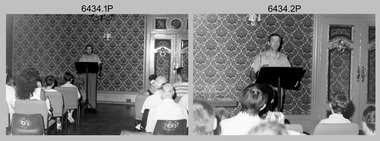 Bendigo Military Museum
Photograph - Army Survey Regiment Open Day - Briefings and Tours, Fortuna, Bendigo, 1990
These 27 photographs were taken at an Army Survey Regiment Open Day at Fortuna Villa, Bendigo on the 24th of February 1990. This occasion was one of several events held to commemorate the 75th anniversary of the formation of the Royal Australian Survey Corps. Although historical tours of Fortuna occurred on a regular basis, this was the first technical open day since 1972. The Royal Australian Survey Corps recognised that an Open Day was the best way for the local community in Bendigo to gain an insight into the unit’s important role as Defence’s map production agency, its technical equipment, and its economic importance to Bendigo. It also gave them an opportunity to tour through historic Fortuna Villa. This occasion is covered in more detail in page 143 of Valerie Lovejoy’s book 'Mapmakers of Fortuna – A history of the Army Survey Regiment’ ISBN: 0-646-42120-4. Refer to items 6435.35P and 6436.18P for more photos of the Open Day taken in the Map Production areas of Air Survey and Cartographic Squadron, and production areas of Lithographic Squadron. Photo prints of some of these photos were scanned and catalogued in items 6247.30P and 6291.6P.These 27 photographs were taken at an Army Survey Regiment Open Day held at Fortuna, Bendigo on the 24th of February 1990. The 35mm colour and black & white negatives photographs were scanned at 96 dpi and are part of the Army Survey Regiment’s Collection. .1) & .2) - Photo, black & white, 1990. Ballroom - Visitor briefings by CO LTCOL Rene van den Tol. .3) - Photo, colour, 1990. Ballroom - Visitor briefings by MAJ Ray Redman. .4) - Photo, colour, 1990. Ballroom - Visitor briefings by unidentified UK Exchange officer. .5) - Photo, black & white, 1990. Music Room - Visitor briefings by MAJ Bob Williams. .6) - Photo, black & white, 1990. Orderly Room - ADJT CAPT Peter Parkes. .7) - Photo, colour, 1990. Music Room - ADJT CAPT Peter Parkes with civilian visitors. .8) - Photo, colour, 1990. Music Room - Visitor briefings by CPL Le-Anne (Smallshaw) Shirley. .9) - Photo, colour, 1990. Entrance Foyer - Visitor briefings. .10) - Photo, colour, 1990. CO’s Office - Visitor briefings by CPL Raelene (Munting) Brodie. .11) - Photo, colour, 1990. Mr Pat Thwaites outlining utilisation of satellite imagery to civilian visitors. .12) - Photo, black & white, 1990. Mr Pat Thwaites outlining utilisation of satellite imagery to civilian visitors. .13) - Photo, colour, 1990. Staircase leading up to the top floor - Visitor briefings by CPL Ian Nelson. .14) - Photo, colour, 1990. Building 16 - Visitor briefings by RSM WO1 Neville Stone. .15) - Photo, colour, 1990. Civilian visitors enjoying views of the garden from Fortuna Villa’s rooftop. .16) - Photo, black & white, 1990. Visitor briefings at Fortuna’s rear steps. .17) - Photo, black & white, 1990. Outside Building 16 - Visitor briefings by WO1 Gary Warnest. .18) - Photo, colour, 1990. Outside Building 16 - Visitor briefings by WO2 Adrian ‘Charlie’ Creedy. .19) - Photo, colour, 1990. Outside Building 16 - L to R: SPR Sue (Foote) Bourne, LCPL Sandy Winn, WO2 Adrian ‘Charlie’ Creedy. .20) - Photo, colour, 1990. Outside Building 16 - SGT Greg Byers. .21) - Photo, colour, 1990. Visitors enjoying Devonshire Tea in the gardens next to the Tavern. .22) - Photo, colour, 1990. RSM WO1 Neville Stone and family enjoying Devonshire Tea in the gardens next to the Tavern. .23) - Photo, colour, 1990. Visitors relaxing in the garden next to Fortuna’s lake. .24) - Photo, black & white, 1990. CPL Trevor Poll and others serve up BBQ lunch next to the tennis courts. .25) to .27) - Photo, colour, 1990. Parking at a premium inside the Army Survey Regiment and Chum Street..1P to .27P – no annotationsroyal australian survey corps, rasvy, army survey regiment, army svy regt, fortuna, asr -
 Melbourne Tram Museum
Magazine, Metropolitan Transit Authority (MTA), "Met Lines", October 1985 - December 1985
Magazine, published by the Metropolitan Transit Authority of Victoria "Met Lines" (Metlines) - A4, printed on white gloss paper, with the MTA logo or symbol. Issued under the name of L. A. Strouse as Chairman. Continues from Reg Item 1058 "Met Lines" - printed in an A3 version, Now a monthly version printed in an A4 size. Major tram and bus items listed. Tramway and bus names only listed, not railway. .1 - Vol 1 No. 5 - August 1985 - 20 pages - announcement of trams for Hong Kong, Minister Tom Roper, tram posters, an article on the work of the TMSV with photos. Retired tramway employees association, Minister visiting Brunswick depot, Melbourne Brighton Bus Lines joins the Met - has photos of staff. .2 - Vol 1 No. 6 - September 1985 - 20 pages - tram emergency crew - derailment of 34 at Russell and Burke and Emergency crew at work and in front of truck, Joe Saccasan foreman at South Melbourne and artist, Doncaster Bus depot, The Met Transporter at the Royal Melbourne show. .3 - Vol 1 No. 7 - October 1985- 20 pages - front page Emery Worldwide courier Elizabeth Sciberra with driver John Edwards, competition to detail a photo of cable tram conductor with very large safety pins (for the bell punch tickets), Hong Kong Kowloon-Canton KCRC inspection tour of Preston Workshops, new tram track construction, Essendon depot Soccer Club premiers winners, Malvern Depot photos and story, Norm Cross and making of Malcolm, Conductor training at Hawthorn depot, photo of enthusiast Paul Jordan, Bus and Coach Society of Victoria article with photos of MMTB Double Decker 244 and a Thornycroft bus No. 14. Article on MMTB uniforms - cable trams, PMTT with photos. .4 - Vol 1 No. 8 - November 1985 - 20 pages - front page cable sketches of cable trams - Met Annual Report, Personnel management, 100 years of Melbourne's tram - many photographs, history timeline for trams, Marketing new posters (See Reg Item 585), tram tours, the Outer Circle Railway - bike path, Essendon depot to be redeveloped, lunch at Hawthorn Training School, tram wheel grinding - James Hajjar. .5 - Vol No. 9 - December 1985 - 20 pages - MTCO Conductor competition - Ray Marsh, Met Posters, Footscray Bus Depot, Scrubber trams, calendar, tram centenary celebrations a success, old Bourke St head office plaque unveiling by Tom Roper and Keith Kings of TMSV, Eric Hobday MMTB Relieving Depot Master remembers the cable trams last day, Alan Jennings retirement, lists personnel movements within The Met. For next year 1986 - see Reg Item 1086trams, tramways, mta, the met, cable trams, conductors, bell punch, hong kong, tram track, malcolm, training, hawthorn, bscv, buses, uniforms, pmtt, mmtb, annual reports, personnel, 100 years of electric trams, posters, outer circle railway, footscray depot, scrubber tram, tmsv, posters, melbourne brighton bus, brunswick depot, r10 vehicle, emergency, derailments, tram 8w, tram 11w, tram 34 -
 National Wool Museum
Program, Dennys Lascelles Limited: Staff Reunion at the National Wool Centre 1988
A copy of both the ‘Dennys Lascelles Limited 1857-1957: Annual Wool Report & Centenary Review’ & ‘Staff Reunion Souvenir Programme, 1988’ was donated to the museum in 2021. These were duplicate items so only their story was retained in addition to the image of Rita located in Multimedia. “Enclose two items which may be of interest to add to your collection. They belonged to my mother, Rita Sedgwick (nee Glenn), who died earlier this year in April. She worked for Dennys Lascelles in two separate periods. First as a young girl, who had finished her schooling, at Morongo Presbyterian ladies College, having been sent as boarder there by her parents from their farm at Mathoura (just north of Echuca). This period was from 1942 — 1947. It was her second job out of school having worked first at the then Geelong Telephone Exchange. She would commute daily to work on a bicycle from where she was then living in Drumcondra. She had the front office role of receptionist and telephonist driving an old manual switchboard. The old front desk was her domain. She departed in 1947, shortly after she was married in late 1946. She spoke fondly of her times at the company as a young girl in her late teens and early twenties. Her second stint was much later, but again as the front-desk telephonist and receptionist commencing in 1972, ending 11 years later in 1983. This was a period when Sir Henry Bolte was on the Board, Don Urqhuart was MD, Ray Hobson was General Manger, Cliff Bone the company Secretary, Peter Keys the CFO and Jim Hay was also on the Executive team. While there were some 25 years between her periods of service, she welcomed the chance to re-join the company. Again, it was a time of hard work, and good friends. The busy times were the wool auctions, when the Firm would be visited by representatives of the big Japanese trading houses such as Mitsui, and Kanematsu. The Chief Auctioneer, Mr. Reeves (I can't recall his first name), would hold court at the now demolished Geelong Wool Exchange — I saw him in action once — what a sight. The huge show floors in the Denny's building would be full of open bales and samples for the buyers to inspect, and for mum days would start at 0800, and finish at 1800 or later. In quieter times over summer, it was reported that the empty show floor would provide an excellent arena for the more enthusiastic cricketers to get in a bit of practise with a tennis ball at lunch and after closing time! Dennys was a full-service firm for wool growers, with branches all over the Western Districts as far afield as Mt Gambier, but through Timboon, Warrnambool, and the like, as I am sure you are aware. She also saw the merger of Dennys and Strachan to create DSM, and later the amalgamation with AML&F to create Dennys AML (I think). She saw the change from the old manual switch board to the then latest of PABX technologies and was part of the team the relocated from the original offices to the new address on the south side of Brougham Street. Along with the shift from the large show floor-based sales of the past. She retired from fulltime work in mid-1983, again with fond memories and friendships that lasted a lifetime. I found these two items among her things recently, and felt that given her connection to the industry, and the place in which the Museum now resides you may like to add them to the collection. I hope you can find a home for them, and that they might add a little to the story that the wool museum now houses and curates.” Program 12pp: soft pale grey cover, contians brief history of the company , the buildings and at the last page is a list of acceptances for the reunion, 2nd October, 1988Judith Lagingdennys, lascelles limited