Showing 24286 items matching "oceans"
-
 Lakes Entrance Historical Society
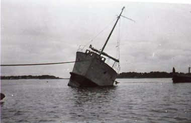
Photograph, 1920c
Black and white photograph showing unidentified vessel in channel. Vessel leaning to one side, rope securing it off to the left. Entrance to ocean obscured behind the vessel that appears to have run aground. Lakes Entrance Victoriaships and shipping, shipwrecks, waterways, ocean, fishing industry -
 Lakes Entrance Historical Society
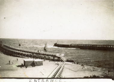
Photograph - The Entrance, 1920c
Second copy 10 x 15 brownish toningBlack and white photograph showing piers at entrance to Gippsland Lakes from ocean Bass Strait. Sailing boat in entrance. Kiosk on sand between eastern pier and boardwalk. Few people on beach. Lakes Entrance VictoriaEntranceboardwalk, waterways, piers, boats and boating -
 Lakes Entrance Historical Society
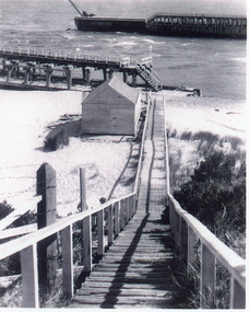
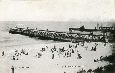
Photograph - Entrance Beach, 1917c
One other copy enlarged 25 x 17.5 cmBlack and white photograph showing tip of western pier and north end of eastern pier at entrance to Gippsland Lakes from ocean Bass Strait. Boardwalk and kiosk on beach, window of kiosk closed. Lakes Entrance Victoria waterways, restaurant, beaches, boardwalk -
 Lakes Entrance Historical Society
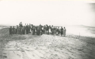
Photograph - Snowy River Marlo Victoria
Number 1 in series of fiveBlack and white photographic print showing excavation of an entrance to the ocean at the mouth of the Snowy River with Cape Conran in distance on right. Group of workmen and visitors with horses and scoops on sand Marlo Victoria. Number 1 in series of fivetownship, rivers -
 Bendigo Military Museum
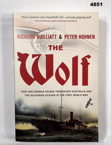
Book - BOOK, WW1 NAVAL HISTORY, GUILLIATT Richard & HOHNEN Peter, " THE WOLF', 2009
"THE WOLF' How one German raider terrorised Australia and the Southern Oceans in the First World War.Soft cover book. Soft cover - cardboard, red and black print on front, spine and back. Cover - colour illustrated - front - top German symbol, bottom, ship at sea. Back - sepia photograph - sailor and girl. 366 pages - cut, plain, off white paper. Illustrated black and white photographs and maps.Nilbook, ww1, naval operations -
 Lakes Entrance Historical Society
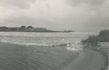
Photograph, Lake Bunga and ocean Victoria
Taken after a recent flood event. The ocean waters foam when it meets fresh water. Black and white photograph of the entrance to Lake Bunga Victoriaocean, waterways -
 Disability Sport & Recreation Victoria
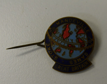
Lapel pin, Stoke-Mandeville Games - Great Britain lapel pin
Round lapel pin.Image of the map of the world, light blue oceans, bright red abstract outlines of continents. Surrounded by navy blue border with STOKE MANDEVILLE GAMES GREAT BRITAIN written in gold.stoke-mandeville games -
 Glenelg Shire Council Cultural Collection
Photograph - Photograph - Portland Harbour, 1930s
Black and white photo, white border. View of the Harbour, Portland, from clifftop, looking east. Baths, Ocean Pier, Railway Pier, Fishermen's Breakwater, Battery Point in background. 'THE HARBOUR, PORTLAND', black print, lower border -
Glenelg Shire Council Cultural Collection
Souvenir - Souvenir Pennant - Portland, Victoria, n.d
Souvenir felt pennant. Black felt, plain on back, yellow felt hanging tabs. Image of cargo ship in port, in orange and white, orange and white printing 'PORTLAND AUSTRALIA VICTORIA'S DEEP SEA PORT ON THE SOUTHERN OCEAN'souvenir of portland, portland harbour, deep sea port, southern ocean -
Glenelg Shire Council Cultural Collection
Photograph - Photograph - aerial view of Portland coastline, c. 1954
Black and white aerial photograph of coastline around Portland. Black border, scale all sides, 5 rows of 3 't' at regular intervals. Mostly ocean, small area of land top left. See Other Information.Front: '820 - 47' - handwritten, white, border 'RUN 6' 'PORTLAND', printed, white, borderport of portland archives, aerial photography, portland harbour, south west coastline -
Glenelg Shire Council Cultural Collection
Photograph - Photograph - aerial view of Portland, c. 1954
Black and white aerial photograph of coastline around Portland. Black border, scale all sides, 5 rows of 3 't' at regular intervals. Half ocean, half land, separated by beach, further left than 8472Front: '607 - 91 ' - handwritten, white, border 'RUN - 6 PORTLAND', printed, white, borderaerial photography, central portland, portland harbour, south west coastline -
Glenelg Shire Council Cultural Collection
Negative - Negative - View from Henty Beach lawns Portland, Victoria, Zilah Maschmedt, c. 1934
Negative for a black and white photograph. Image shows view from Henty Beach lawns, looking towards Whaler's Bluff. Beach shelters, samd,, Railway Pier, Baths, Ocean Pier, lighthouse and water tower on Whaler's Bluff. -
Glenelg Shire Council Cultural Collection
Photograph - Photograph - aerial view of Portland, c. 1954
Black and white aerial photograph of coastline around Portland. Black border, scale all sides, 5 rows of 3 't' at regular intervals. 75/25 land to ocean. Further left than 8475, ?end of beach.Front: '607 - 94 ' - handwritten, white, border 'RUN - 6 PORTLAND', printed, white, borderaerial photography, central portland, portland harbour, south west coastline -
Glenelg Shire Council Cultural Collection
Photograph - Photograph - aerial view of Portland, c. 1954
Black and white aerial photograph of coastline around Portland. Black border, scale all sides, 5 rows of 3 't' at regular intervals. Curved section of coastline top right corner. 90/10 ocean to landFront: '784 - 154'- handwritten, white, border 'RUN 7 A PORTLAND', printed, white, borderport of portland archives, aerial photography, portland harbour, south west coastline -
Glenelg Shire Council Cultural Collection
Photograph - Photograph - aerial view of Portland, c. 1954
Black and white aerial photograph of coastline around Portland. Black border, scale all sides, 5 rows of 3 't' at regular intervals. Right hand end of headland no longer visible. 50/50 ocean to land.Front: '784 - 151'- handwritten, white, border 'RUN A PORTLAND', printed, white, borderaerial photography, central portland, portland harbour, south west coastline -
 Lakes Entrance Historical Society
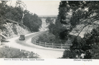
Postcard - Princes Highway Kalimna, Bulmer H D, 1935c
Black and white postcard of the Princes Highway as it winds around Jemmys Point. A motor car driving up the hill between steep road cutting and post and rail fence. View of the lake and ocean in the distance. Lakes Entrance VictoriaBend in Princes Highway, Lakes Entrance fences, roads and streets -
 Lakes Entrance Historical Society
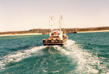
Photograph - Southern Hope, Hammarstrom Ian, 1987 c
Colour photograph of the fishing boat Southern Hope approaching the entrance channel, from the ocean, shows sandy beach each side of entrance piers and shallow water over the outer bar, sea calm. Lakes Entrance Victoriaships and shipping, waterways, fishing industry -
 Lakes Entrance Historical Society
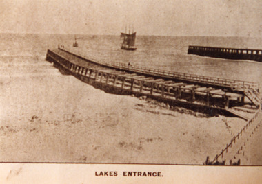
Photograph - Entrance Piers, 1890c
Sepia photograph showing entrance from ocean Bass Strait to Gippsland Lakes. Early wooden piers, trading ship being towed out through entrance by small steamer, beach and boardwalk in foreground. Lakes Entrance VictoriaLakes Entrancejetties, ocean, waterways, public works -
 Lakes Entrance Historical Society
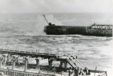
Photograph - Entrance Beach, Bulmer H D, 1910c
One other copy slightly sepia tinted 12 x 19cmBlack and white photograph showing piers and entrance to Gippsland Lakes from ocean Bass Strait. Work in progress on concrete extension to western pier showing cranes and machinery in use. People on beach and piers. Lakes Entrance VictoriaLakes Entrancewaterways, beaches, piers, machinery -
 Lakes Entrance Historical Society
Photograph - Western Pier, 1918c
Black and white photograph showing piers and entrance to lakes from ocean Bass Strait. Western pier in back ground shows concrete extension to original wooden pier. Wooden eastern pier in foreground. Lakes Entrance Victoriapiers, waterways -
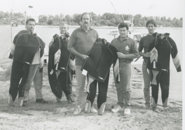 Lakes Entrance Historical Society
Photograph - Ocean Rescue, Lakes Post Newspaper, 1996
Black and white photograph of Erin Strickland, David Hammerstrom, Phillip Baade, Fred Smittou, and President of Apex Tony Barnes at presentation of new wetsuits for the Ocean Rescue purchased with funds donated by Apex Club, Lakes Entrance Victoria.community services, volunteering, emergency services -
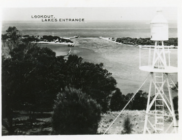 Lakes Entrance Historical Society
Photograph - The Entrance, 1950c
Also postcard 7 x 10.5, similar image,Black and white photograph of the entrance, taken from lookout on Jemmys Point, shows signal light adjacent to lookout, people on slope in front of signal, New Works cottages on hummocks, ocean horizon in distance. Lakes Entrance VictoriaThe Entrance from Jemmy's Pointwaterways, ocean, navigation -
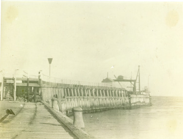 Lakes Entrance Historical Society
Photograph, Phillips Miss L, Entrance to Gippsland Lakes: Lakes Entrance, 1910c
Black and white photograph showing Eastern Pier and entrance to Gippsland Lakes from ocean - Bass Strait, photo shows work shed and crane on end of pier ready to build concrete extension on pier. Lakes Entrance Victoriapiers, ships and shipping, gippsland lakes -
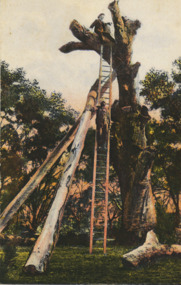 Lakes Entrance Historical Society
Postcard - Lookout Tree 1890, W T Potter, 1890 c
Black and white postcard of the tall trunk of a dead grey box tree supported by two heavy timber trusses, a long wooden ladder for access to the top area for viewing the lakes and ocean from Jemmys Point Kalimna VictoriaLookout tree Lakes Entrance Cunninghame Victorianavigation -
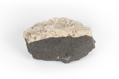 The Beechworth Burke Museum
Geological specimen - Hyalite in Basalt
According to the 1912 Department of Mines Bulletin of the Geological Survey of Victoria, basalt covers a considerable portion of the Macedon area including Mount Macedon. Basalt is the most common form of rock underlying the earth's surface and is found in three kinds of rock forming environments: ocean divergent boundaries, oceanic hotspots, and mantle plumes and hotspots beneath continents.This specimen is part of a larger collection of geological and mineral specimens collected from around Australia (and some parts of the world) and donated to the Burke Museum between 1868-1880. A large percentage of these specimens were collected in Victoria as part of the Geological Survey of Victoria that begun in 1852 (in response to the Gold Rush) to study and map the geology of Victoria. Collecting geological specimens was an important part of mapping and understanding the scientific makeup of the earth. Many of these specimens were sent to research and collecting organisations across Australia, including the Burke Museum, to educate and encourage further study.A solid mass, geological specimen in shades of grey and white. Hyalite is a colourless variety of opal. It occurs as globular and botryoidal masses and irregular crusts in volcanic and pegmatite environments where the silica deposits from the gas phase. Basalt is dark in colour, fine-grained igneous rock composed of plagioclase and pyroxene minerals. It is commonly formed as an extrusive rock, such as lava flow. It is one of the most common forms of rock underlying the earth's surface.burke museum, geological specimen, department of mines, geological survey of victoria, basalt, mount macedon, beechworth -
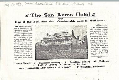 Phillip Island and District Historical Society Inc.
Newspaper clippings, 1903
Donated by Miss Edith Elms via Chrisy Northcote. Show the development of San Remo as a recreational area in 1903.Photocopy of San Remo Hotel advertisement inserted by T Bergin - Proprietor - undated, listing activities - ocean beach, exquisite scenery, excellent fishing, bathing, golf, cycling, riding, driving. Photograph of San Remo Hotel top middle.local history, documents, newspapers, san remo, local area development by europeans, black & white newspaper clipping, advertisement, newspapers san remo -
 Glenelg Shire Council Cultural Collection
Photograph - Photograph - Portland, n.d
Con Kroker Collection -
Glenelg Shire Council Cultural Collection
Photograph - Photograph - Early Shipping: Ocean / Railway Pier, n.d
Port of Portland Authority Archivesport of portland archives, railway pier, ocean pier -
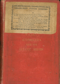 Bendigo Historical Society Inc.
Book - AUSTRALASIA AND THE OCEANIC REGION, 1876
Wildey's Australasia and the Oceanic Region by William Brackley Wildey, red hard cover with gold lettering, sticker on front Eaglehawk Public Library, 426 pages with information about Australia. Published by George Robertson, printed by Ferguson and Moore Melbourne.australasia, william wildey, geography, history -
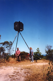 Lakes Entrance Historical Society
Photograph - Lakes Entrance Grid location, 1999
Lakes Entrance Grid reference, Cunninghame 8522.3.4 896.082, on ten acre site with trig point, it is from this point that all the survey for the surrounding areas was undertaken. Part of the Vic Geodetic Survey initiated in 1860 by Ellery Survey started from triangulation base in Werribee. (Grid ref B'dale 8422)Colour photograph of the Victoria Geodetic Survey Triangulation Station, Trig Station, situated off Ocean View Parade, Merrangbaur Hill. Location is indicated by ground point and standing structure, situated on an elevated bush block. Lakes Entrance Victoriasurveying, township planning