Showing 573 items
matching old maps
-
 Kew Historical Society Inc
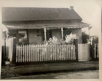
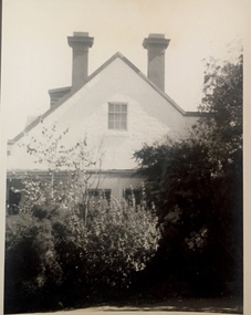
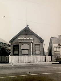
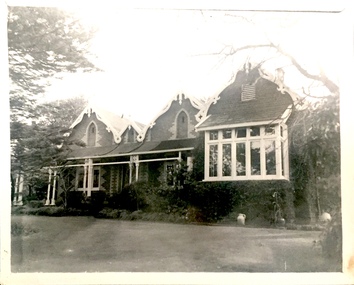
Photograph, J E & B L Rogers, 'Fairyland Cottage', 57 Malmsbury Street, c.1960
This work forms part of the collection assembled by the historian Dorothy Rogers, that was donated to the Kew Historical Society by her son John Rogers in 2015. The manuscripts, photographs, maps, and documents were sourced by her from both family and local collections or produced as references for her print publications. Many were directly used by Rogers in writing ‘Lovely Old Homes of Kew’ (1961) and 'A History of Kew' (1973), or the numerous articles on local history that she produced for suburban newspapers. Most of the photographs in the collection include detailed annotations in her hand.The Rogers Collection provides a comprehensive insight into the working habits of a historian in the 1960s and 1970s. Together it forms the largest privately-donated collection within the archives of the Kew Historical Society.Small, black and white photo of 57 Malmsbury Street, Kew. Originally the home of the grandparents of the historian Dorothy Rogers, it was later known as Fairyland when owned by Jim and Grace Tabulo."Fairyland Cottage. Built c.1860. This was grandma's home in 1866. Mother and father were married in the right hand room in 1884 by Martin Hosking (see marriage lines). / I would like this in my family story."fairyland -- 57 malmsbury street -- kew (vic.), weatherboard cottages -- kew (vic), houses -- malmsbury street -- kew (vic) -
 Kew Historical Society Inc
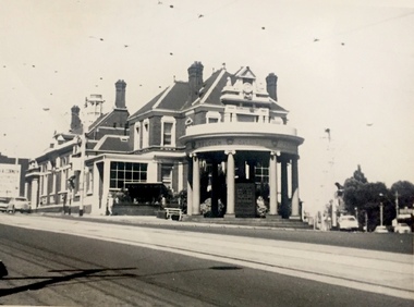
Photograph, J E & B L Rogers, Kew Post Office, 1967
This work forms part of the collection assembled by the historian Dorothy Rogers, that was donated to the Kew Historical Society by her son John Rogers in 2015. The manuscripts, photographs, maps, and documents were sourced by her from both family and local collections or produced as references for her print publications. Many were directly used by Rogers in writing ‘Lovely Old Homes of Kew’ (1961) and 'A History of Kew' (1973), or the numerous articles on local history that she produced for suburban newspapers. Most of the photographs in the collection include detailed annotations in her hand.The Rogers Collection provides a comprehensive insight into the working habits of a historian in the 1960s and 1970s. Together it forms the largest privately-donated collection within the archives of the Kew Historical Society.Small, black and white photo of Kew Post Office in 1967."1967 / Kew Post Office / Commissioned in 1887; completed 1888 at a cost of 10,000 [pounds]. Court House is seen at extreme left. (See other picture for Police Station & residence)."kew post office, public buildings -- kew (vic.) -
 Kew Historical Society Inc
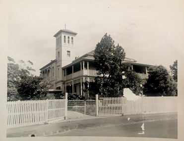
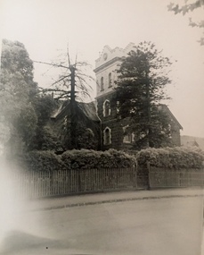
Photograph, J E & B L Rogers, 'Fernhurst', c.1959
This work forms part of the collection assembled by the historian Dorothy Rogers, that was donated to the Kew Historical Society by her son John Rogers in 2015. The manuscripts, photographs, maps, and documents were sourced by her from both family and local collections or produced as references for her print publications. Many were directly used by Rogers in writing ‘Lovely Old Homes of Kew’ (1961) and 'A History of Kew' (1973), or the numerous articles on local history that she produced for suburban newspapers. Most of the photographs in the collection include detailed annotations in her hand.The Rogers Collection provides a comprehensive insight into the working habits of a historian in the 1960s and 1970s. Together it forms the largest privately-donated collection within the archives of the Kew Historical Society.Small, black and white photo of Fernhurst in Kew, built for the architect and surveyor George Wharton. (Now demolished)"Probably built in 1860s / Fernhurst"fernhurst -- kew (vic), historical houses -- kew (vic), kew mansions -
 Kew Historical Society Inc
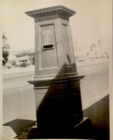
Photograph, J E & B L Rogers, Pillar Box, High Street, 1950s
This work forms part of the collection assembled by the historian Dorothy Rogers, that was donated to the Kew Historical Society by her son John Rogers in 2015. The manuscripts, photographs, maps, and documents were sourced by her from both family and local collections or produced as references for her print publications. Many were directly used by Rogers in writing ‘Lovely Old Homes of Kew’ (1961) and 'A History of Kew' (1973), or the numerous articles on local history that she produced for suburban newspapers. Most of the photographs in the collection include detailed annotations in her hand.The Rogers Collection provides a comprehensive insight into the working habits of a historian in the 1960s and 1970s. Together it forms the largest privately-donated collection within the archives of the Kew Historical Society.Small, black and white photo of a pillar box in High Street, Kew, outside the Boroondara General (Kew) Cemetery. "Pillar Box / Old shop / Kew Cemetery"pillar boxes -- kew (vic.), high street -- kew (vic.) -
 Kew Historical Society Inc
Photograph, J E & B L Rogers, 'Turinville', Barnard Grove, 1950s
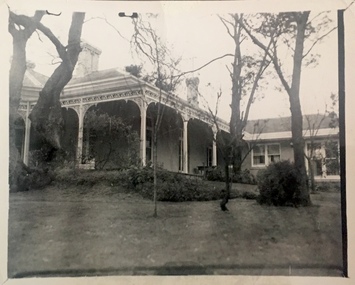
This work forms part of the collection assembled by the historian Dorothy Rogers, that was donated to the Kew Historical Society by her son John Rogers in 2015. The manuscripts, photographs, maps, and documents were sourced by her from both family and local collections or produced as references for her print publications. Many were directly used by Rogers in writing ‘Lovely Old Homes of Kew’ (1961) and 'A History of Kew' (1973), or the numerous articles on local history that she produced for suburban newspapers. Most of the photographs in the collection include detailed annotations in her hand.The Rogers Collection provides a comprehensive insight into the working habits of a historian in the 1960s and 1970s. Together it forms the largest privately-donated collection within the archives of the Kew Historical Society.Small, black and white photo of the front of 'Turinville' in Barnard Grove, Kew. "Turinville / Note new addition on right / 11"turinville -- barnard grove -- kew (vic), historic houses -- kew (vic) -
 Kew Historical Society Inc
Photograph, J E & B L Rogers, German Plaques, 'Roseneath', Pakington Street, 1950s
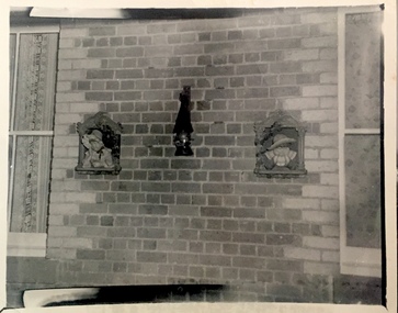
This work forms part of the collection assembled by the historian Dorothy Rogers, that was donated to the Kew Historical Society by her son John Rogers in 2015. The manuscripts, photographs, maps, and documents were sourced by her from both family and local collections or produced as references for her print publications. Many were directly used by Rogers in writing ‘Lovely Old Homes of Kew’ (1961) and 'A History of Kew' (1973), or the numerous articles on local history that she produced for suburban newspapers. Most of the photographs in the collection include detailed annotations in her hand.The Rogers Collection provides a comprehensive insight into the working habits of a historian in the 1960s and 1970s. Together it forms the largest privately-donated collection within the archives of the Kew Historical Society.Small, black and white photo of the front of 'Turinville' in Barnard Grove, Kew. "German Plaques. Back wall of Roseneath. 30"roseneath -- pakington street -- kew (vic.), historic houses -- kew (vic) -
 Kew Historical Society Inc
Photograph, J E & B L Rogers, 'Campion Hall', Studley Park Road, 1950s
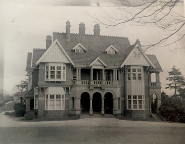
This work forms part of the collection assembled by the historian Dorothy Rogers, that was donated to the Kew Historical Society by her son John Rogers in 2015. The manuscripts, photographs, maps, and documents were sourced by her from both family and local collections or produced as references for her print publications. Many were directly used by Rogers in writing ‘Lovely Old Homes of Kew’ (1961) and 'A History of Kew' (1973), or the numerous articles on local history that she produced for suburban newspapers. Most of the photographs in the collection include detailed annotations in her hand.The Rogers Collection provides a comprehensive insight into the working habits of a historian in the 1960s and 1970s. Together it forms the largest privately-donated collection within the archives of the Kew Historical Society.Small, black and white photo of the front of 'Campion Hall' [formerly Dalsraith], 99 Studley Park Road, Kew. It was designed by Architects Ussher and Kemp. It was built in 1906 as a home for S.W. Gibson of the firm Foy and Gibson, Drapers, of Melbourne. "Chap 76 / Campion Hall / Dalswraith (Gibsons) / Built about 1906 / 19"dalsraith -- dalswraith, campion house -- campion hall, glendalough -
 Kew Historical Society Inc
Photograph, J E & B L Rogers, High Street, Looking to Junction, 1960s
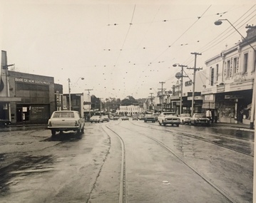
This work forms part of the collection assembled by the historian Dorothy Rogers, that was donated to the Kew Historical Society by her son John Rogers in 2015. The manuscripts, photographs, maps, and documents were sourced by her from both family and local collections or produced as references for her print publications. Many were directly used by Rogers in writing ‘Lovely Old Homes of Kew’ (1961) and 'A History of Kew' (1973), or the numerous articles on local history that she produced for suburban newspapers. Most of the photographs in the collection include detailed annotations in her hand.The Rogers Collection provides a comprehensive insight into the working habits of a historian in the 1960s and 1970s. Together it forms the largest privately-donated collection within the archives of the Kew Historical Society.Small, black and white photo of High Street, Kew, looking west towards Kew Junction."High St / Looking towards Junction / Jim's / 4high street -- kew (vic.), shopping strips -- melbourne -
 Kew Historical Society Inc
Photograph, J E & B L Rogers, F. Baynes House, Queens Street, 1960s
This work forms part of the collection assembled by the historian Dorothy Rogers, that was donated to the Kew Historical Society by her son John Rogers in 2015. The manuscripts, photographs, maps, and documents were sourced by her from both family and local collections or produced as references for her print publications. Many were directly used by Rogers in writing ‘Lovely Old Homes of Kew’ (1961) and 'A History of Kew' (1973), or the numerous articles on local history that she produced for suburban newspapers. Most of the photographs in the collection include detailed annotations in her hand.The Rogers Collection provides a comprehensive insight into the working habits of a historian in the 1960s and 1970s. Together it forms the largest privately-donated collection within the archives of the Kew Historical Society.Small, black and white photo of a house in Queen Street, Kew."Built 1856. F. Baynes House. Queen St. (Once faced Cotham Rd). Not published. This is side of house - shops now built along frontage".historic houses -- kew (vic.), houses -- queen street -- kew (vic) -
 Kew Historical Society Inc
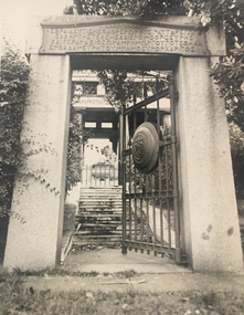
Photograph, J E & B L Rogers, Gates of Springthorpe Memorial, 1950s
This work forms part of the collection assembled by the historian Dorothy Rogers, that was donated to the Kew Historical Society by her son John Rogers in 2015. The manuscripts, photographs, maps, and documents were sourced by her from both family and local collections or produced as references for her print publications. Many were directly used by Rogers in writing ‘Lovely Old Homes of Kew’ (1961) and 'A History of Kew' (1973), or the numerous articles on local history that she produced for suburban newspapers. Most of the photographs in the collection include detailed annotations in her hand.The Rogers Collection provides a comprehensive insight into the working habits of a historian in the 1960s and 1970s. Together it forms the largest privately-donated collection within the archives of the Kew Historical Society.Small, black and white photo of the entrance gates to the Springthorpe Memorial in the Borondara General (Kew) Cemetery. "Springthorpe. Gates of Memorial / Memorial Gate / Jim's / 12"springthorpe memorial -- boroondara general (kew) cemetery, mausoleums - kew cemetery -
 Kew Historical Society Inc
Photograph, J E & B L Rogers, Xavier College, c.1970
This work forms part of the collection assembled by the historian Dorothy Rogers, that was donated to the Kew Historical Society by her son John Rogers in 2015. The manuscripts, photographs, maps, and documents were sourced by her from both family and local collections or produced as references for her print publications. Many were directly used by Rogers in writing ‘Lovely Old Homes of Kew’ (1961) and 'A History of Kew' (1973), or the numerous articles on local history that she produced for suburban newspapers. Most of the photographs in the collection include detailed annotations in her hand.The Rogers Collection provides a comprehensive insight into the working habits of a historian in the 1960s and 1970s. Together it forms the largest privately-donated collection within the archives of the Kew Historical Society.Small, black and white photo of the facade of Xavier College Senior School."Xavier College / Jim's / 35"xavier college -- kew (vic.), schools -- kew (vic) -
 Kew Historical Society Inc
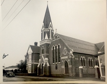
Photograph, J E & B L Rogers, Methodist Church, Highbury Grove, c.1970
This work forms part of the collection assembled by the historian Dorothy Rogers, that was donated to the Kew Historical Society by her son John Rogers in 2015. The manuscripts, photographs, maps, and documents were sourced by her from both family and local collections or produced as references for her print publications. Many were directly used by Rogers in writing ‘Lovely Old Homes of Kew’ (1961) and 'A History of Kew' (1973), or the numerous articles on local history that she produced for suburban newspapers. Most of the photographs in the collection include detailed annotations in her hand.The Rogers Collection provides a comprehensive insight into the working habits of a historian in the 1960s and 1970s. Together it forms the largest privately-donated collection within the archives of the Kew Historical Society.Small, black and white photo of the Methodist Church in Highbury Grove, Kew."Methodist Church / Jim's / 40"churches -- kew (vic.), methodist church -- highbury grove -- kew (vic.) -
 Kew Historical Society Inc
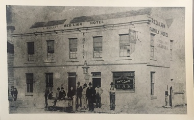
Print, E. Reilly's Red Lion Family Hotel, Nineteenth Century
This work forms part of the collection assembled by the historian Dorothy Rogers, that was donated to the Kew Historical Society by her son John Rogers in 2015. The manuscripts, photographs, maps, and documents were sourced by her from both family and local collections or produced as references for her print publications. Many were directly used by Rogers in writing ‘Lovely Old Homes of Kew’ (1961) and 'A History of Kew' (1973), or the numerous articles on local history that she produced for suburban newspapers. Most of the photographs in the collection include detailed annotations in her hand.The Rogers Collection provides a comprehensive insight into the working habits of a historian in the 1960s and 1970s. Together it forms the largest privately-donated collection within the archives of the Kew Historical Society.Small, black and white copy of a photo of E. Reilly's Red Lion [Family] Hotel, in Hawthorn.hotels -- hawthorn (vic.), red lion hotel -- hawthorn, e reilly -- publican -
 Kew Historical Society Inc
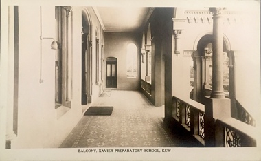
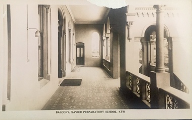
Postcard, Balcony, Xavier Preparatory School, Kew, 1920-1921
This work forms part of the collection assembled by the historian Dorothy Rogers, that was donated to the Kew Historical Society by her son John Rogers in 2015. The manuscripts, photographs, maps, and documents were sourced by her from both family and local collections or produced as references for her print publications. Many were directly used by Rogers in writing ‘Lovely Old Homes of Kew’ (1961) and 'A History of Kew' (1973), or the numerous articles on local history that she produced for suburban newspapers. Most of the photographs in the collection include detailed annotations in her hand.The Rogers Collection provides a comprehensive insight into the working habits of a historian in the 1960s and 1970s. Together it forms the largest privately-donated collection within the archives of the Kew Historical Society.Sepia postcard, one of a series of views of Xavier Preparatory School [Burke Hall], located in the house in Nolan Avenue formerly known as Waverley, then Studley Hall."Balcony, Xavier Preparatory School, Kew / POST CARD / A REAL PHOTOGRAPH / PRODUCED IN AUSTRALIA"burke hall -- kew (vic), xavier preparatory school, postcards -- kew (vic.) -
 Kew Historical Society Inc
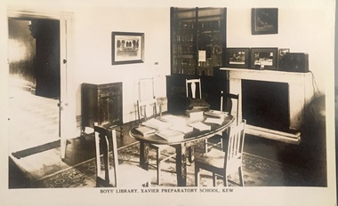
Postcard, Boy's Library, Xavier Preparatory School, Kew, 1920-1921
This work forms part of the collection assembled by the historian Dorothy Rogers, that was donated to the Kew Historical Society by her son John Rogers in 2015. The manuscripts, photographs, maps, and documents were sourced by her from both family and local collections or produced as references for her print publications. Many were directly used by Rogers in writing ‘Lovely Old Homes of Kew’ (1961) and 'A History of Kew' (1973), or the numerous articles on local history that she produced for suburban newspapers. Most of the photographs in the collection include detailed annotations in her hand.The Rogers Collection provides a comprehensive insight into the working habits of a historian in the 1960s and 1970s. Together it forms the largest privately-donated collection within the archives of the Kew Historical Society.Sepia postcard, one of a series of views of Xavier Preparatory School [Burke Hall], located in the house in Nolan Avenue formerly known as Waverley, then Studley Hall."Boy's Library, Xavier Preparatory School, Kew / POST CARD / A REAL PHOTOGRAPH / PRODUCED IN AUSTRALIA" / "Office"burke hall -- kew (vic), xavier preparatory school, postcards -- kew (vic.) -
 Kew Historical Society Inc
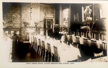
Postcard, Boy's Dining Room, Xavier Preparatory School, Kew, 1920-1921
This work forms part of the collection assembled by the historian Dorothy Rogers, that was donated to the Kew Historical Society by her son John Rogers in 2015. The manuscripts, photographs, maps, and documents were sourced by her from both family and local collections or produced as references for her print publications. Many were directly used by Rogers in writing ‘Lovely Old Homes of Kew’ (1961) and 'A History of Kew' (1973), or the numerous articles on local history that she produced for suburban newspapers. Most of the photographs in the collection include detailed annotations in her hand.The Rogers Collection provides a comprehensive insight into the working habits of a historian in the 1960s and 1970s. Together it forms the largest privately-donated collection within the archives of the Kew Historical Society.Sepia postcard, one of a series of views of Xavier Preparatory School [Burke Hall], located in the house in Nolan Avenue formerly known as Waverley, then Studley Hall."Boy's Dining Room, Xavier Preparatory School, Kew / POST CARD / A REAL PHOTOGRAPH / PRODUCED IN AUSTRALIA" / "Burke Hall"burke hall -- kew (vic), xavier preparatory school, postcards -- kew (vic.) -
 Kew Historical Society Inc
Postcard, Balcony, Xavier Preparatory School, Kew, 1920-1921
This work forms part of the collection assembled by the historian Dorothy Rogers, that was donated to the Kew Historical Society by her son John Rogers in 2015. The manuscripts, photographs, maps, and documents were sourced by her from both family and local collections or produced as references for her print publications. Many were directly used by Rogers in writing ‘Lovely Old Homes of Kew’ (1961) and 'A History of Kew' (1973), or the numerous articles on local history that she produced for suburban newspapers. Most of the photographs in the collection include detailed annotations in her hand.The Rogers Collection provides a comprehensive insight into the working habits of a historian in the 1960s and 1970s. Together it forms the largest privately-donated collection within the archives of the Kew Historical Society.Sepia postcard, one of a series of views of Xavier Preparatory School [Burke Hall], located in the house in Nolan Avenue formerly known as Waverley, then Studley Hall."Balcony, Xavier Preparatory School, Kew / POST CARD / A REAL PHOTOGRAPH / PRODUCED IN AUSTRALIA" / "Burke Hall"burke hall -- kew (vic), xavier preparatory school, postcards -- kew (vic.) -
 Kew Historical Society Inc
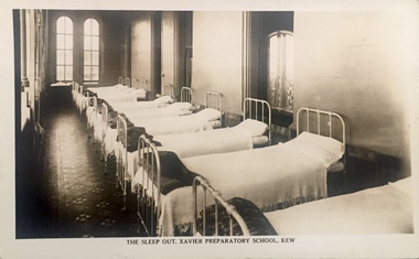
Postcard, The Sleep Out, Xavier Preparatory School, Kew, 1920-1921
This work forms part of the collection assembled by the historian Dorothy Rogers, that was donated to the Kew Historical Society by her son John Rogers in 2015. The manuscripts, photographs, maps, and documents were sourced by her from both family and local collections or produced as references for her print publications. Many were directly used by Rogers in writing ‘Lovely Old Homes of Kew’ (1961) and 'A History of Kew' (1973), or the numerous articles on local history that she produced for suburban newspapers. Most of the photographs in the collection include detailed annotations in her hand.The Rogers Collection provides a comprehensive insight into the working habits of a historian in the 1960s and 1970s. Together it forms the largest privately-donated collection within the archives of the Kew Historical Society.Sepia postcard, one of a series of views of Xavier Preparatory School [Burke Hall], located in the house in Nolan Avenue formerly known as Waverley, then Studley Hall."The Sleep Out, Xavier Preparatory School, Kew / POST CARD / A REAL PHOTOGRAPH / PRODUCED IN AUSTRALIA" / "Top Verandah"burke hall -- kew (vic), xavier preparatory school, postcards -- kew (vic.) -
 Kew Historical Society Inc
Postcard, Study Hall, Xavier Preparatory School, Kew, 1920-1921
This work forms part of the collection assembled by the historian Dorothy Rogers, that was donated to the Kew Historical Society by her son John Rogers in 2015. The manuscripts, photographs, maps, and documents were sourced by her from both family and local collections or produced as references for her print publications. Many were directly used by Rogers in writing ‘Lovely Old Homes of Kew’ (1961) and 'A History of Kew' (1973), or the numerous articles on local history that she produced for suburban newspapers. Most of the photographs in the collection include detailed annotations in her hand.The Rogers Collection provides a comprehensive insight into the working habits of a historian in the 1960s and 1970s. Together it forms the largest privately-donated collection within the archives of the Kew Historical Society.Sepia postcard, one of a series of views of Xavier Preparatory School [Burke Hall], located in the house in Nolan Avenue formerly known as Waverley, then Studley Hall."Study Hall, Xavier Preparatory School, Kew / POST CARD / A REAL PHOTOGRAPH / PRODUCED IN AUSTRALIA" / "Ballroom"burke hall -- kew (vic), xavier preparatory school, postcards -- kew (vic.) -
 Kew Historical Society Inc
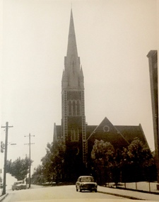
Photograph, Kew Presbyterian Church, c.1959
This work forms part of the collection assembled by the historian Dorothy Rogers, that was donated to the Kew Historical Society by her son John Rogers in 2015. The manuscripts, photographs, maps, and documents were sourced by her from both family and local collections or produced as references for her print publications. Many were directly used by Rogers in writing ‘Lovely Old Homes of Kew’ (1961) and 'A History of Kew' (1973), or the numerous articles on local history that she produced for suburban newspapers. Most of the photographs in the collection include detailed annotations in her hand.The Rogers Collection provides a comprehensive insight into the working habits of a historian in the 1960s and 1970s. Together it forms the largest privately-donated collection within the archives of the Kew Historical Society.Small black and white photograph of Cotham Road, Kew with the Kew Presbyterian Church at right."Presbyterian Church Cotham Rd"kew presbyterian church, churches -- cotham road -- kew (vic.), neo gothic churches, churches -- kew 9vic) -
 Kew Historical Society Inc
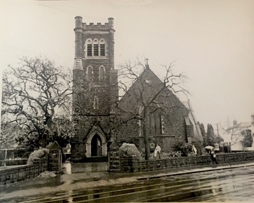
Photograph, Holy Trinity Church, 1960s
This work forms part of the collection assembled by the historian Dorothy Rogers, that was donated to the Kew Historical Society by her son John Rogers in 2015. The manuscripts, photographs, maps, and documents were sourced by her from both family and local collections or produced as references for her print publications. Many were directly used by Rogers in writing ‘Lovely Old Homes of Kew’ (1961) and 'A History of Kew' (1973), or the numerous articles on local history that she produced for suburban newspapers. Most of the photographs in the collection include detailed annotations in her hand.The Rogers Collection provides a comprehensive insight into the working habits of a historian in the 1960s and 1970s. Together it forms the largest privately-donated collection within the archives of the Kew Historical Society.Small black and white photograph of Holy Trinity Church, High Street, Kew."Holy Trinity Church / Jim Bowden / 37"holy trinity church -- kew (vic.), churches -- kew (vic) -
 Kew Historical Society Inc
Photograph, Salvation Army Hall, Kew, 1967
This work forms part of the collection assembled by the historian Dorothy Rogers, that was donated to the Kew Historical Society by her son John Rogers in 2015. The manuscripts, photographs, maps, and documents were sourced by her from both family and local collections or produced as references for her print publications. Many were directly used by Rogers in writing ‘Lovely Old Homes of Kew’ (1961) and 'A History of Kew' (1973), or the numerous articles on local history that she produced for suburban newspapers. Most of the photographs in the collection include detailed annotations in her hand.The Rogers Collection provides a comprehensive insight into the working habits of a historian in the 1960s and 1970s. Together it forms the largest privately-donated collection within the archives of the Kew Historical Society.Small black and white photograph of the Salvation Army Hall in High Street, Kew (now demolished)."Salvation Army / Kew 1967"churches -- kew (vic), salvation army -- high street -- kew (vic.) -
 Kew Historical Society Inc
Photograph, 'Ivy Grange', 1-3 Malmsbury Street, c.1959
This work forms part of the collection assembled by the historian Dorothy Rogers, that was donated to the Kew Historical Society by her son John Rogers in 2015. The manuscripts, photographs, maps, and documents were sourced by her from both family and local collections or produced as references for her print publications. Many were directly used by Rogers in writing ‘Lovely Old Homes of Kew’ (1961) and 'A History of Kew' (1973), or the numerous articles on local history that she produced for suburban newspapers. Most of the photographs in the collection include detailed annotations in her hand.The Rogers Collection provides a comprehensive insight into the working habits of a historian in the 1960s and 1970s. Together it forms the largest privately-donated collection within the archives of the Kew Historical Society.Small black and white photograph of the bluestone mansion, 'Ivy Grange', 1-3 Malmsbury Street, Kew."Ivy Grange"historic houses -- kew (vic), bluestone buildings -- kew (vic.), ivy grange, houses -- malmsbury street -- kew (vic.) -
 Kew Historical Society Inc
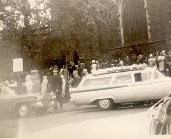
Photograph, Lady Rylah's Funeral, Holy Trinity Church, 1969
This work forms part of the collection assembled by the historian Dorothy Rogers, that was donated to the Kew Historical Society by her son John Rogers in 2015. The manuscripts, photographs, maps, and documents were sourced by her from both family and local collections or produced as references for her print publications. Many were directly used by Rogers in writing ‘Lovely Old Homes of Kew’ (1961) and 'A History of Kew' (1973), or the numerous articles on local history that she produced for suburban newspapers. Most of the photographs in the collection include detailed annotations in her hand.The Rogers Collection provides a comprehensive insight into the working habits of a historian in the 1960s and 1970s. Together it forms the largest privately-donated collection within the archives of the Kew Historical Society.Ann Flora Froude Flashman (Lady Rylah), (1911-1969) was an Australian veterinarian. The wife of Sir Arthur Rylah she died in 1969. The small black and white photograph shows the hearse and casket outside Holy Trinity Church.funerals -- holy trinity church -- kew (vic), churches -- kew (vic.), lady rylah -
 Kew Historical Society Inc
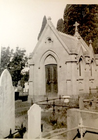
Photograph, Cussen Memorial, Boroondara General (Kew) Cemetery, c.1959
This work forms part of the collection assembled by the historian Dorothy Rogers, that was donated to the Kew Historical Society by her son John Rogers in 2015. The manuscripts, photographs, maps, and documents were sourced by her from both family and local collections or produced as references for her print publications. Many were directly used by Rogers in writing ‘Lovely Old Homes of Kew’ (1961) and 'A History of Kew' (1973), or the numerous articles on local history that she produced for suburban newspapers. Most of the photographs in the collection include detailed annotations in her hand.The Rogers Collection provides a comprehensive insight into the working habits of a historian in the 1960s and 1970s. Together it forms the largest privately-donated collection within the archives of the Kew Historical Society.Small black and white snapshot of the Cussen Memorial in the Boroondara General Cemetery. The memorial was commissioned by Sir Leo Cussen, a judge of the Victorian Supreme Court as a memorial to his son, Hubert. The chapel is designed in the Gothic Revival style."Cussen Memorial / Kew Cemetery"boroondara general (kew) cemetery, cussen memorial -
 Kew Historical Society Inc
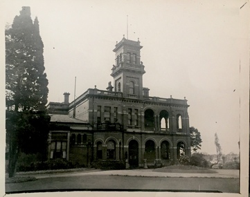
Photograph, 'Raheen', Studley Park Road, c.1959
This work forms part of the collection assembled by the historian Dorothy Rogers, that was donated to the Kew Historical Society by her son John Rogers in 2015. The manuscripts, photographs, maps, and documents were sourced by her from both family and local collections or produced as references for her print publications. Many were directly used by Rogers in writing ‘Lovely Old Homes of Kew’ (1961) and 'A History of Kew' (1973), or the numerous articles on local history that she produced for suburban newspapers. Most of the photographs in the collection include detailed annotations in her hand.The Rogers Collection provides a comprehensive insight into the working habits of a historian in the 1960s and 1970s. Together it forms the largest privately-donated collection within the archives of the Kew Historical Society.Small black and white photograph of Raheen in Studley Park Road, Kew."Raheen / ca. 1870 by Ed. Latham / Palace of Roman (Catholic Archbishop) / 2 views either one / 22"raheen -- studley park road -- kew (vic), edward latham, archbishop mannix -
 Kew Historical Society Inc
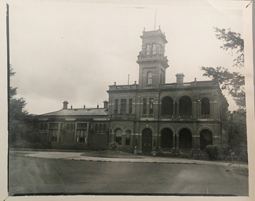
Photograph, 'Raheen', Studley Park Road, c.1959
This work forms part of the collection assembled by the historian Dorothy Rogers, that was donated to the Kew Historical Society by her son John Rogers in 2015. The manuscripts, photographs, maps, and documents were sourced by her from both family and local collections or produced as references for her print publications. Many were directly used by Rogers in writing ‘Lovely Old Homes of Kew’ (1961) and 'A History of Kew' (1973), or the numerous articles on local history that she produced for suburban newspapers. Most of the photographs in the collection include detailed annotations in her hand.The Rogers Collection provides a comprehensive insight into the working habits of a historian in the 1960s and 1970s. Together it forms the largest privately-donated collection within the archives of the Kew Historical Society.Small black and white photograph of Raheen in Studley Park Road, Kew."20"raheen -- studley park road -- kew (vic), edward latham, archbishop mannix -
 Kew Historical Society Inc
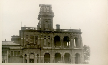
Photograph, 'Raheen', Studley Park Road, c.1959
This work forms part of the collection assembled by the historian Dorothy Rogers, that was donated to the Kew Historical Society by her son John Rogers in 2015. The manuscripts, photographs, maps, and documents were sourced by her from both family and local collections or produced as references for her print publications. Many were directly used by Rogers in writing ‘Lovely Old Homes of Kew’ (1961) and 'A History of Kew' (1973), or the numerous articles on local history that she produced for suburban newspapers. Most of the photographs in the collection include detailed annotations in her hand.The Rogers Collection provides a comprehensive insight into the working habits of a historian in the 1960s and 1970s. Together it forms the largest privately-donated collection within the archives of the Kew Historical Society.Small black and white photograph of Raheen in Studley Park Road, Kew."21"raheen -- studley park road -- kew (vic), edward latham, archbishop mannix -
 Kew Historical Society Inc
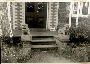
Photograph, Lions, 'Roseneath', Pakington Street, c.1959
This work forms part of the collection assembled by the historian Dorothy Rogers, that was donated to the Kew Historical Society by her son John Rogers in 2015. The manuscripts, photographs, maps, and documents were sourced by her from both family and local collections or produced as references for her print publications. Many were directly used by Rogers in writing ‘Lovely Old Homes of Kew’ (1961) and 'A History of Kew' (1973), or the numerous articles on local history that she produced for suburban newspapers. Most of the photographs in the collection include detailed annotations in her hand.The Rogers Collection provides a comprehensive insight into the working habits of a historian in the 1960s and 1970s. Together it forms the largest privately-donated collection within the archives of the Kew Historical Society.Small black and white photograph of the entrance with guardian lions at Roseneath, Pakington Street, Kew.roseneath -- pakington street -- kew (vic.), historic houses -- kew (vic.) -
 Kew Historical Society Inc
Photograph, 'Roseneath', Pakington Street, c.1959
This work forms part of the collection assembled by the historian Dorothy Rogers, that was donated to the Kew Historical Society by her son John Rogers in 2015. The manuscripts, photographs, maps, and documents were sourced by her from both family and local collections or produced as references for her print publications. Many were directly used by Rogers in writing ‘Lovely Old Homes of Kew’ (1961) and 'A History of Kew' (1973), or the numerous articles on local history that she produced for suburban newspapers. Most of the photographs in the collection include detailed annotations in her hand.The Rogers Collection provides a comprehensive insight into the working habits of a historian in the 1960s and 1970s. Together it forms the largest privately-donated collection within the archives of the Kew Historical Society.Small black and white photograph of Roseneath in Pakington Street, Kew.roseneath -- pakington street -- kew (vic.), historic houses -- kew (vic.)