Showing 2321 items matching "parish"
-
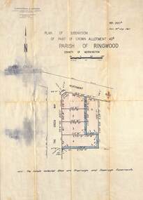
 Ringwood and District Historical Society
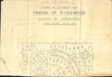
Document - Plan of Subdivision, Part of Crown Allotment 40C, Parish of Ringwood, County of Mornington - (Undated, circa 1960s)
Top portion (only) of clipped map on light paper backing showing residential allotments on The Boulevard, Wendy Court and Beverley Court, Heathmont, Victoria. -
 Ringwood and District Historical Society
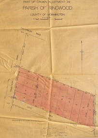
Map - Plan of Subdivision, Part of Crown Allotment 39, Parish of Ringwood, County of Mornington - 1949
Map showing residential allotments numbered 1 to 12 on Armstrong Road and Louis Street, Heathmont, Victoria.Certification signed and dated by Russell Francis Kinnane, Licensed Surveyor, 18th February, 1949. -
 Ringwood and District Historical Society
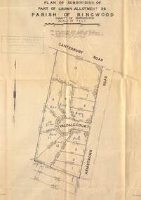
Map - Plan of Subdivision, Part of Crown Allotment 39, Parish of Ringwood, County of Mornington - (Undated, circa 1950)
Map showing residential allotments numbered 1 to 13 on Valdale Court and Armstrong Road off Canterbury Road, Heathmont, Victoria. Richard Rogalsky, Land Surveyor and Town Planner, 25 Napier Street, Essendon (at Essendon Junction) 37-2642 - 37-6570. -
 Ringwood and District Historical Society
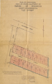
Map - Plan of Subdivision, Part of Crown Allotment 39, Parish of Ringwood, County of Mornington - 1949
Map showing residential allotments numbered 1 to 18 on Armstrong Road and Harriet Street, Heathmont, Victoria.Certification signed and dated by Russell Francis Kinnane, Licensed Surveyor, 12th October, 1949. -
 Ringwood and District Historical Society
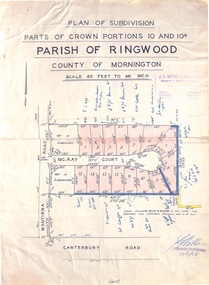
Map - Plan of Subdivision, Parts of Crown Portions 10 and 10B Parish of Ringwood - 1958
Folded subdivision map of 15 residential allotments in McKay Court Ringwood, off Wantirna Road north of Canterbury Road. Rubber stamped by Surveyors and Chartered Engineers J.S. Watson & Associates, Mornington and South Yarra, with illegible signature dated 17/2/58. Handwritten notations indicating allotment sale names and amounts or where passed in. Accompanying clipping on scrap paper backing from Land Sale Brochure with description of available services and local facilities and terms of sale - £75 Deposit £10 Monthly. -
 Ringwood and District Historical Society
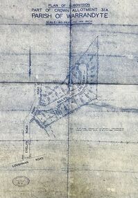
Map - Plan of Subdivision, Part of Crown Allotment 31A, Parish of Warrandyte - (Undated)
Facsimile blueprint copy of 24 residential allotments with property dimensions in Bailey Crescent (later Gabriella Court) and McEwan Street (later Suzanne Court) off Park Road and Evelyn Road, Ringwood North. Attached photocopy of undated map of allotment on south-east corner of Evelyn and Park Roads.Rubber stamp impression - J. Horne, Licensed Surveyor, 458 Nepean Highway, Frankston 31736. -
 Ringwood and District Historical Society
Map - Subdivision Plan, Part of Crown Allotment 39, Parish of Ringwood, County of Mornington, Heathmont, Victoria - (Undated - circa 1950s)
Hand-drawn map on light cardboard backing showing location and size of 6 allotments on western side of Armstrong Road near Canterbury Road, Heathmont. -
 Stawell Historical Society Inc
Map, Parish of Crowlands, Sheet 2 1957, 1954
A0 MapParish of Crowlands, Sheet 2 1957stawell -
 Ringwood and District Historical Society
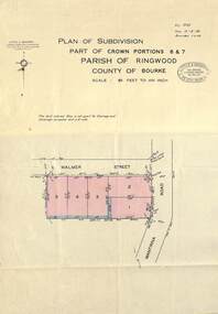
Map - Plan of Subdivision, Part of Crown Portions 6 & 7, Parish of Ringwood, County of Bourke - 1960
Copy of land title map on light cardboard backing showing layout and size of 5 residential allotments in Walmer Street and Wantirna Road, Ringwood, Victoria.Ref. 3725 Date 15-8-1960 Amended 7-9-1960. Little & Brosnan, Licensed Surveyors & Engineers, 422 Little Collins Street, Melbourne. Telephone MU 5111. -
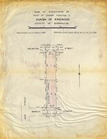 Ringwood and District Historical Society
Map - Plan of Subdivision, Part of Crown Portions 6 Parish of Ringwood, County of Mornington - (Undated, circa 1950s)
Copy of land title map on light cardboard backing showing layout and imperial sizes of 2 residential allotments in Arlington Street and Barkly Street, Ringwood, Victoria. -
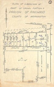 Ringwood and District Historical Society
Map, Plan of Subdivision - Part of Crown Portion 3, Parish of Ringwood, County of Mornington (Undated, circa 1930s)
Hand-drawn map of subdivided allotments in Molan Street and New Street Ringwood, south of railway line.Real estate sales notations on some allotments possibly added post decimal currency changeover date, 1966. Weatherboard shop marked on south-west corner of New Street and Whitehorse Road. -
 Ringwood and District Historical Society
Map - Plan of Subdivision, Part of Crown Allotment 40B, Parish of Ringwood, County of Mornington - 1965
Map showing residential allotments numbered 1 to 5 on Heathmont Road and The Greenway, Heathmont, Victoria.Ref. 2937A Date 19 July 1965. Kirkpatrick & Webber, Licensed Surveyors, Civil Engineers & Town Planners, Maroondah Highway, Ringwood Telephone 870 0321. -
 Eltham District Historical Society Inc
Document - Photocopy, Survey Field Notes of Part of Crown Portion 13, Section 4 at Eltham, Part of Lot 19 Subdivision of 13 Section IV (Holloways), Parish of Nillumbik, County of Evelyn, 5 May 1906
Portion of land bounded by: Main Road, Henry Street Application 35953 A. Mackensie Tyers, Licensed Surveyor, 5 May 1906map, neil webster collection, survey plan, surveyor field notes, 1906, application 33777, application 35953, henry street, main road eltham, maria street, rechabite hall* -
 Eltham District Historical Society Inc
Document - Photocopy, Survey Field Notes of Part of Crown Portion 12, Section 4 at Eltham, Parish of Nillumbik, County of Evelyn, 4 July 1924
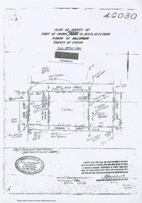
Portion of land bounded by: Main Road, Pitt Street, Bible Street, Franklin Street Application 46030 R.H. Woodcock, Licensed Surveyor, 4 July 1924map, neil webster collection, survey plan, surveyor field notes, 1924, application 46030, bible street, corn store, ernie andrew, franklin street, l. grant, main road eltham, maria street, peel street, pitt street -
 Eltham District Historical Society Inc
Document - Photocopy, Survey Field Notes of Part of Crown Portion 13, Section 4 at Eltham, Parish of Nillumbik, County of Evelyn, 29 May 1919
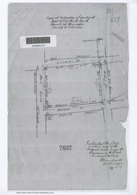
Portion of land bounded by: Main Road, Luck Street, Bible Street, Arthur Street Application 7637 R.H. Woodcock, Licensed Surveyor, 29 May 19191919, application 7637, arthur street, bible street, luck street, main road eltham, map, neil webster collection, survey plan, surveyor field notes -
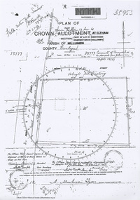
![Document - Photocopy, Survey Field Notes of Part of Crown Portion 13, Section 4 at Eltham, Parish of Nillumbik, County of Evelyn [Bourke sic], 30 September 1949](/media/collectors/4f729f7b97f83e03086018a5/items/6869da03f3688aa02254c5c2/item-media/6869da22f3688aa02254c6da/item-fit-380x285.jpg) Eltham District Historical Society Inc
Eltham District Historical Society IncDocument - Photocopy, Survey Field Notes of Part of Crown Portion 13, Section 4 at Eltham, Parish of Nillumbik, County of Evelyn [Bourke sic], 30 September 1949
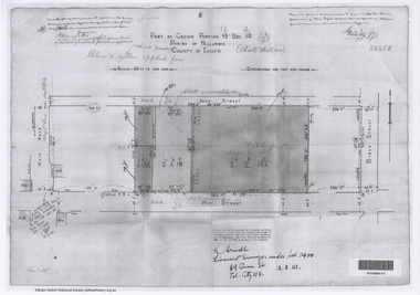
Portion of land bounded by: Main Road, Arthur Street, Dudley Street Application 21718 Erwin Dillon, Licensed Surveyor, 30 September 1949map, neil webster collection, survey plan, surveyor field notes, 1949, application 21718, arthur street, dudley street, main road eltham -
 Eltham District Historical Society Inc
Document - Photocopy, Survey Field Notes of Part of Crown Portion 12, Section 4 at Eltham, Parish of Nillumbik, County of Evelyn, 12 August 1910
Portion of land bounded by: Main Road, John Street, Bible Street, Pitt Street Application 38858 K. Arndt, Licensed Surveyor, 12 August 1910map, neil webster collection, survey plan, surveyor field notes, 1910, application 38858, bible street, john street, main road eltham, pitt street -
 Ringwood and District Historical Society
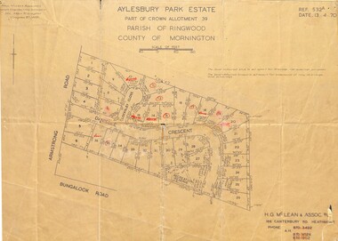
Map - Plan of Subdivision, Aylesbury Park Estate, Part of Crown Allotment 39, Parish of Ringwood, County of Mornington - 1970
Map showing residential allotments for sale in Armstrong Road, Danielle Crescent and Locksley Close, Heathmont, Victoria.Ref.532A Date 13.4.70. Paul Millar & Associates, Land & Engineering Surveyors, 14A Main Street Croydon (Phone) 723 4493. Ref.532A Date 13.4.70. (Agent) H.G. McLean & Assoc P/L, 166 Canterbury Road Heathmont, Phone 8703422 A.H. 8706726 8700112. -
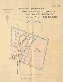 Ringwood and District Historical Society
Map - Plan of Subdivision, Part of Crown Allotment 39, Parish of Ringwood, County of Mornington - 1968
Map showing residential allotments numbered 1 to 14 Headline Court, Heathmont, Victoria, off Bronaldi Street and Yallamba Place. Adjoining lot 15 marked as 2 acres 3 roods 29.8 perches with house and garage.Paul Millar & Associates, Land & Engineering Surveyors, First Floor, 14A Main Street Croydon (Phone) 723 4493. Ref. 232B Date 23.1.68 Amended 12.3.68 & 1.12.71. -
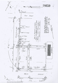 Eltham District Historical Society Inc
Document - Photocopy, Survey Field Notes of Part of Crown Portion 13, Section 4 at Eltham, Parish of Nillumbik, County of Evelyn, 18 October 1946
Portion of land bounded by: Main Road, Henry Street, Bible Street Application 18650 W. Connolly, Licensed Surveyor, 18 October 1946map, neil webster collection, survey plan, surveyor field notes, 1946, application 18650, bible street, henry street, main road eltham, maria street, rose street -
 Ringwood and District Historical Society
Document - Subdivision Map, Part of Crown Sections 18, 19, 24 & 25, Parish of Warrandyte, County of Evelyn, Vol 5228 Fol 472 - 1926. (Park Orchards, Victoria)
A3 and A4 sized photocopies showing map section of land title showing streets, easements and allotment numbers, some with handwritten names and pricing notations circa mid 1950s.Map includes Valley Road, Granard Avenue, Park Road, Arundel Avenue, Hylton Avenue, Aviemore Avenue, Bowmore Avenue, Hopetoun Road, Colin Avenue, Daintree Avenue, Brucedale Crescent, Feversham Avenue, Ennismore Crescent, Iona Grove, Elgin Crescent and Gosford Crescent, Park Orchards, Victoria. -
 Ringwood and District Historical Society
Document - Map, Plan of Subdivision - Part of Crown Allotments 14A & 14C, Parish of Ringwood, County of Mornington, Vol 5378 Fol 511 - 1927
Department of Lands and Survey photocopy dated 17/1/1951, page number 12308.Map includes Canterbury Road, Heathmont Road, Dickasons Road, Bennett Avenue, Orchid Street and Allens Road, Heathmont, Vic. -
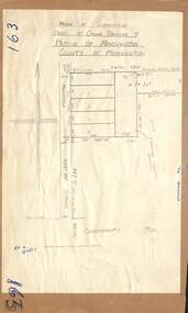
 Ringwood and District Historical Society
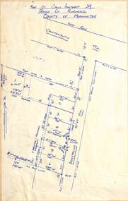
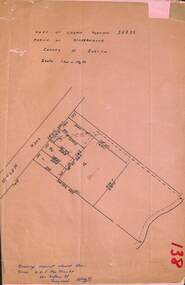
Document, Plan of Subdivision - Part of Crown Portion 5, Parish of Ringwood, County of Bourke - (Undated)
Map showing layout of 4 numbered allotments coloured red and land coloured blue appropriated or set aside for drainage and sewerage puposes.Map includes Nelson Street and Ringwood Street, Ringwood, Vic. -
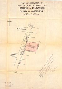 Ringwood and District Historical Society
Document, Plan of Subdivision - Part of Crown Allotment 26A, Parish of Ringwood, County of Mornington - Circa 1961
Map showing layout of 2 allotments coloured red in Velma Grove, adjacent to Valda Avenue and Mirabel Avenue, Ringwood East, Vic.Handwritten notation dated 29/8/1961 by Alf King, Licensed Surveyor, 14 Grace Street, Mont Albert (Phone) WX2020 regarding plans being forwarded to Council for inspection visit. -
 Ringwood and District Historical Society
Map - Plan of Subdivision, Part of Crown Portion 7, Parish of Ringwood, County of Mornington - circa 1950
Hand-drawn map attached to light cardboard backing showing 5 residential allotments on eastern side of Maidstone Street Ringwood, north of Canterbury Road.RFK 8/11/51 -
 Ringwood and District Historical Society
Map - Plan of Subdivision, Part of Crown Portions 32 & 33, Parish of Warrandyte, County of Evelyn - 1951
Map attached to light cardboard backing showing size and location of 4 residential allotments on Mullum Mullum Road Ringwood, east of Warrandyte Road.Owner - G.H.F. MacMullen 36a Mullum Road, Ringwood - 23 August 1951. -
 Narre Warren and District Family History Group
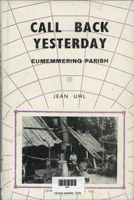
Book, Jean Uhl, Call Back Yesterday - Eumemmerring Parish, 1972
Eumemmerring covers a large area on the south-eastern (Dandenong) perimeter of Melbourne. Jean Uhl traces the development of this once peaceful district into a thriving, modern, industrial zone with its noise, its buildings and its land speculations. Through it we can follow the evolution of Australia from a primary producing company in the nineteenth century to a rapidly expanding industrial nation in the twentieth century. Personalities, buildings and landmarks are presented and discussed with loving care, thus making this book one of the most noteable local histories to be published in recent time in Victoria.xii, 109 p.; 24 cmnon-fictionEumemmerring covers a large area on the south-eastern (Dandenong) perimeter of Melbourne. Jean Uhl traces the development of this once peaceful district into a thriving, modern, industrial zone with its noise, its buildings and its land speculations. Through it we can follow the evolution of Australia from a primary producing company in the nineteenth century to a rapidly expanding industrial nation in the twentieth century. Personalities, buildings and landmarks are presented and discussed with loving care, thus making this book one of the most noteable local histories to be published in recent time in Victoria. eumemmerring (vic.), dandenong (vic.), dandenong (vic.) - history -
 Narre Warren and District Family History Group
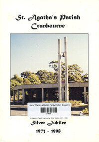
Book, St Agatha's Church (Cranbourne), St Agatha's Parish Cranbourne: Silver Jubilee 1973 - 1998
A book about the silver jubilee of St Agatha's Parish Cranbourne: 1973 - 1998non-fictionA book about the silver jubilee of St Agatha's Parish Cranbourne: 1973 - 1998cranbourne (vic.), st agatha's parish cranbourne -
 Ringwood and District Historical Society
Document - Map, Part of Crown Allotment 27C, Parish of Warrandyte, County of Evelyn, Ringwood, Victoria - c.1970
Photocopy of subdivision plan 75131 Vol 3439 Fol 712 showing numbered residential allotments with property dimensions.Surveyors and Consulting Engineers - O'Connor & Beveridge, Main Eltham Road, Lower Plenty, Tel. 432668. Rubber-stamped "Photocopy - Titles Office Complied 17 Feb 1970". Map includes Lockhart Road, Lansell Close, Terrara Place, Goldsmith Avenue, Park Hill Drive, Hilldale Close, and Elm Court, Ringwood, Victoria. -
 Ringwood and District Historical Society
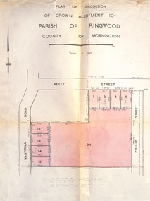
Document, Plan of Subdivision - Part of Crown Allotment 10A, Parish of Ringwood, County of Mornington - 1957
Map of residential allotments in Wantirna Road and Reilly Street, Ringwood, and Philip Street, Heathmont, Vic.Footnote includes "Lots numbered 5 to 11 and 16 to 23 both inclusive are not included in this plan. Signature of Consulting Engineer - Alan J. Brown BCE, LS, MVIS, Licensed Surveyor, Dillons Buildings, 1 Riversdale Road, Camberwell (Phone) WF3528 dated 1-4-1957.