Showing 2304 items matching "parishes"
-
 Federation University Historical Collection
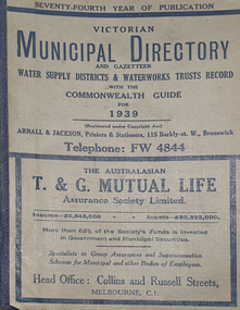
Book - Street Directory, Arnall & Jackson Pty Ltd, Victorian Municipal Directory and Gazatteer, 1939, 1939
Beige cover with blue spine. 1052 pages. It includes an index to townships, parishes and Railway stations. non-fictionvictorian municipalities, municipal, councils, water supply, advertisements, aboriginal protection board, agriculture, charities, county court, crown lands and survey, engine drivers board, licensing court, sludge abatement board, cities, towns, boroughs, ballarat, buninyong, gordon, grenville, talbot, traralgon, ballaarat, happy valley, bungaree, daylesford, glenlyon, glenlyon shire, hepburn springs -
 Federation University Historical Collection
Book - Directory, Arnall & Jackson Pty Ltd, Victorian Municipal Directory and Gazatteer, 1935, 1935
Brown cover with maroon spine. 801 pages. It includes an index to townships, parishes and Railway stations. non-fictionvictorian municipalities, municipal, councils, water supply, advertisements, aboriginal protection board, agriculture, charities, county court, crown lands and survey, engine drivers board, licensing court, sludge abatement board, cities, towns, boroughs, ballarat, buninyong, gordon, grenville, talbot, traralgon, ballaarat, happy valley, bungaree, daylesford, glenlyon, glenlyon shire, hepburn springs -
Federation University Historical Collection
Book - Directory, Arnall & Jackson Pty Ltd, Victorian Municipal Directory and Gazatteer, 1924, 1924
Brown cover with blue spine. 708 pages. It includes an index to townships, parishes and Railway stations. non-fictionvictorian municipalities, municipal, councils, water supply, advertisements, aboriginal protection board, agriculture, charities, county court, crown lands and survey, engine drivers board, licensing court, sludge abatement board, cities, towns, boroughs, ballarat, buninyong, gordon, grenville, talbot, traralgon, ballaarat, happy valley, bungaree, daylesford, glenlyon, glenlyon shire, hepburn springs -
Glenelg Shire Council Cultural Collection
Newspaper - Church Parish News, n.d
25 issues of the Portland Church of England Parish News, from May 1959 - August 1965 -
Ringwood and District Historical Society
Newsletters, Newton Press, 'The Spirit' Quarterly newsletters: Mar-1985 and Jun-1985. Published by the people of the Holy Spirit Parish, North Ringwood, 1985
'The Spirit' Quarterly newsletters: Mar-1985 and Jun-1985. Published by the people of the Holy Spirit Parish. -
 Federation University Historical Collection
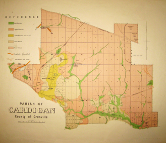
Map - Geological survey, Parish of Cardigan, County of Grenville, c1889
Geological map of the Parish of Cardigan on a cadastral base showing quartz reefs, shafts, alluvial deposits.cardigan, winter's creek, ballarat cattle yards railway, prince of wales park, ballarat, friendly societies reserve, ballarat industrial school reserve, green hill, bunker's hill, sago hill, diamond drill bores, cardigan propriety, half way house, ti tree creek, albion consols, prince imperial, winter's freehold company -
 Bendigo Historical Society Inc.
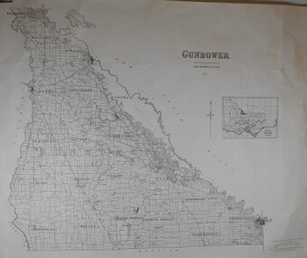
Map - JACK FLYNN COLLECTION: GUNBOWER, 1935
Map: County of Gunbower, map sheet showing the whole of the County of Gunbower and all of the Parishes within.map, gunbower, county, gunbower -
 Bendigo Historical Society Inc.
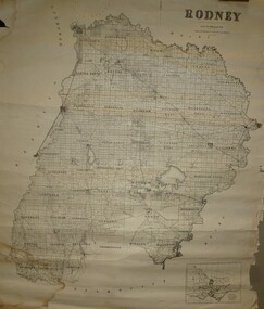
Map - JACK FLYNN COLLECTION: RODNEY, Revised in 1935
Map: County of Rodney, map sheet showing the whole of the County of Rodney and all of the Parishes within.Drawn at the Department of Lands and Survey, Melbourne. Revised to 1935map, rodney, parish plan, rodney -
Bendigo Historical Society Inc.
Map - HUNTLY, 9th June 1880
Map:Huntly, County of Bendigo. Parish plan Canvas backed. ( number 138 in Map Cupboard 1)map, bendigo, city streets, huntly, county of bendigo -
Bendigo Historical Society Inc.
Map - SALISBURY WEST, 14/10/1943
Map: Salisbury West, County of Gladstone. Parish plan ( number 179 in Map Cupboard 1)map, gladstone, parish plan, salisbury west , county of gladstone -
Bendigo Historical Society Inc.
Map - LANGWORNOR, 17/07/1942
Map: Langwornor, County of Dalhousie. Parish Plan, coloured ( number 165 in Map Cupboard 1)map, dalhousie, parish plan, langwornor, county of dalhousie -
Bendigo Historical Society Inc.
Map - COSTERFIELD, 2/09/1939
Map: Costerfield, Counties of Dalhousie and Rodney. Parish plan ( number 163 in Map Cupboard 1)map, dalhousie, parish plan, costerfield, counties of dalhousie and rodney -
Bendigo Historical Society Inc.
Map - ELMORE, 7/08/1911
Map: Township of Elmore, Parish of Elmore, County of Bendigo ( number 159 in Map Cupboard 1)map, bendigo, township, elmore, county of bendigo -
Bendigo Historical Society Inc.
Map - GOORNONG, 1/10/1906
Map: Township of Goornong, Parish of Goornong, County of Bendigo ( number 154 in Map Cupboard 1)map, bendigo, township, goornong, county of bendigo -
Bendigo Historical Society Inc.
Map - GOORNONG, Revised 5/06/1926
Map: Town of Goornong, Parish of Goornong, County of Bendigo ( number 153 in Map Cupboard 1)map, bendigo, township, goornong, county of bendigo -
Bendigo Historical Society Inc.
Map - HUNTLY, 7/01/1904
Map: Township of Huntly, Parish of Huntly, County of Bendigo ( number 150 in Map Cupboard 1)map, bendigo, township, huntly, parish of huntly, county of bendigo -
Bendigo Historical Society Inc.
Map - HARCOURT, 2/04/1917
Map: Town of Harcourt, County of Talbot. Parish plan (number 264 in map cupboard 1)map, talbot, township, harcourt -
Bendigo Historical Society Inc.
Map - TOWNSHIP OF HEATHCOTE SHEET 2, Circa 1935
Map: Township of Heathcote sheet 2. Parish plan (number 254 in map cupboard 1)map, dalhousie, township, heathcote -
Bendigo Historical Society Inc.
Map - TARNAGULLA, Examined May 1883
Map: Tarnagulla, Counties of Gladstone and bendigo. Parish plan ( number 244 in Map Cupboard 1)map, gladstone, parish plan, tarnagulla, gladstone -
Bendigo Historical Society Inc.
Map - EPPALOCK RESURVEY, Circa 1880
Map: Eppalock resurvey, hand draughted parish plan ( number 239 in Map Cupboard 1)map, bendigo, parish plan, eppalock -
Bendigo Historical Society Inc.
Map - CITY OF SANDHURST SHEET NO 4, 25/04/1882
Map: City of sandhurst sheet No. 4. Parish plan ( number 224 in Map Cupboard 1)map, bendigo, parish plan, sandhusrt -
Bendigo Historical Society Inc.
Map - CITY OF SANDHURST SHEET NO. 5, 18/04/1882
Map: City of sandhurst sheet No. 5. Parish plan ( number 223 in Map Cupboard 1)map, bendigo, parish plan, sandhusrt -
Bendigo Historical Society Inc.
Map - CITY OF BENDIGO SHEET NO. 4, Circa 1900
Map: City of Bendigo sheet No. 4. Parish plan ( number 218 in Map Cupboard 1)map, bendigo, parish plan, bendigo -
Bendigo Historical Society Inc.
Map - CITY OF BENDIGO SHEET NO. 2, Circa 1900
Map: City of Bendigo sheet No. 2 . Parish plan ( number 217 in Map Cupboard 1)map, bendigo, parish plan, bendigo -
Bendigo Historical Society Inc.
Map - CITY OF BENDIGO SHEET NO. 6, surveyed 3/03/1882
Map: City of Bendigo sheet No. 6 . Parish plan ( number 215 in Map Cupboard 1)map, bendigo, parish plan, bendigo -
Bendigo Historical Society Inc.
Map - CITY OF BENDIGO SHEET NO. 5, Circa 1890's
Map: City of Bendigo sheet No. 5. Parish plan ( number 213 in Map Cupboard 1)map, bendigo, parish plan, bendigo -
Bendigo Historical Society Inc.
Map - SALISBURY WEST, 29/01/1878
Map: Salisbury West, County of Gladstone. Parish plan (number 305 in map cupboard 1)map, gladstone, parish plan, salisbury west -
Bendigo Historical Society Inc.
Map - JANIEMBER EAST, No date visible
Map: Janiember East, Hand Draughted? Parish plan (number 299 in map cupboard 1)map, bendigo, parish plan, janiember east , serpentine -
Bendigo Historical Society Inc.
Map - AXEDALE, 10/10/1904
Map: Axedale, Counties of Bendigo and Rodney. Parish plan (number 297 in map cupboard 1)map, bendigo, parish plan, axedale -
Bendigo Historical Society Inc.
Map - MANDURANG 2, March 194-?
Map: Mandurang 2, County of Bendigo. Parish plan (number 296 in map cupboard 1)map, bendigo, parish plan, mandurang