Showing 11217 items matching "planning"
-
 Greensborough Historical Society
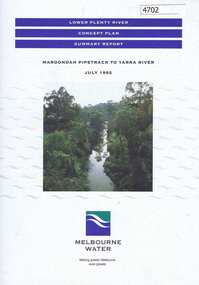
Pamphlet, Lower Plenty River concept plan, summary report: Maroondah Pipetrack to Yarra River, 1992_07
This draft concept plan covers the lower Plenty River from the Maroondah Pipe track in Greensborough to where the Plenty meets the Yarra. Melbourne Water was the lead agency, assisted by the Shires of Eltham and Diamond Valley, City of Heidelberg, the EPA and Department of Planning and Housing.Coloured pamphlet, photograph and plans 12 pages. 2 copies.plenty river, maroondah aqueduct, melbourne water -
 Whitehorse Historical Society Inc.
Article, Plans costed, 1992
Estimated cost of developing historic Matheson's Orchard is $276,000.Estimated cost of developing historic Matheson's Orchard is $276,000. Consultants recommend a five year restoration plan. The Forward Planning Committee voted to form an advisory Committee to help Council program the works, conservation and promotion of the property.Estimated cost of developing historic Matheson's Orchard is $276,000.orchards, matheson, charles, city of nunawading, matheson orchard -
Port Melbourne Historical & Preservation Society
Plan - Proposed Bayside development, Sep 1987
SCDC plans for the Bayside development were revised as investigations into water circulation in artifical canals/harbour were completed. This is the altered plan, with alterations drawn in red on the original proposal, for the EES hearing in September 1987. The EES hearing, scheduled for three days in September, ran for 57 sessions into February 1988.Large plan of original proposed Bayside development as submitted to council in 1987; as 502.01 but with alterations superimposed in red, It was this altered plan that was submitted at the enquiry into the Environmental Effects Statement in September.In blue: EES Variation September 1987:In red: markings to indicate alterations to land configurationtown planning - proposals shelved - bayside, sandridge city development co pty ltd, scdc -
 Greensborough Historical Society
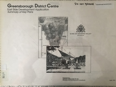
Plan - Application, Wilson Sayer Core Pty Ltd, Greensborough District Centre: East side development application: summary of key plans. 1992, 1992_04
A summary of the plans for the Greensborough District Centre from 1992, with plans for the development of the East side of Main Street Greensborough.16 pages. Black and white line drawings and plans. Has plastic cover and wire binding. greensborough district centre, main street greensborough -
Bialik College
Document (Sub-series) - Architect Ron Unger's papers relating to Shakespeare Grove
... planning ...construction, buildings, planningconstruction, buildings, planning -
 Vision Australia
Plan - Image, Conversion to Administrative offices / Conversion to Rehabilitation centre, 1 November 1962 - 5 April 1963
Over 1962-63, plans were drawn up for the conversion of the main building into administrative offices and a rehabilitation centre. As the children were now located at the school in Burwood, and with funds achieved from the sale of the old factory buildings to the Alfred Hospital, the St Kilda Road building could expand room for its office workers and provide greater floor space to rehabilitation staff. These plans show the proposed conversion from bedrooms to administrative and rehabilitation areas.7 architectural plans and 1 letterJohn F D Scarborough and Partners, Architectsroyal victorian institute for the blind, plans -
 Queenscliffe Maritime Museum
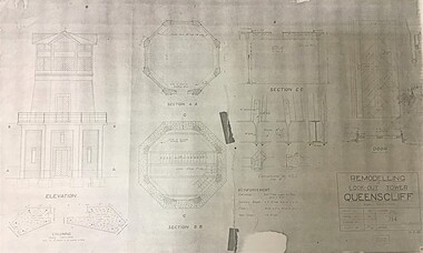
Plan - Plan for a Signal Station Look-out Tower Queenscliff
A plan for the remodelling of the look-out tower at Queenscliff dated 26 April1938Plan for the the remodelling of the look-out tower at Queenscliff dated 1938plan, queenscliff, signal station, look out tower -
 Vision Australia
Plan - Image, New verandah & draining to court for the Royal Victorian Institute for Blind, April 1924
In 1924 plans were submitted to the RVIB board for the addition of a new veranda and associated drainage pipes located in the courtyard behind Ormond Hall. Hand written notes on the plan indicate that the tender for materials from Pollards was 330 pounds, asphalt 35 pounds totally a cost of 365 pounds. And that additional costs of 120 pounds, comprising of 20 for G Lavatory (?) and J Famdy (?) 100 pounds.1 architectural plans for proposed verandah and drainageStephenson & Meldrum, Architects Collins Court 374 Little Collins Street Melbourne Phone: 6990royal victorian institute for the blind, plans -
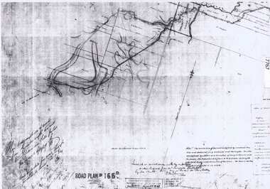 Greensborough Historical Society
Document - Road Plan, Road acquisition, St Helena Road, 1859, 1889
Road plan showing land acquisition for the road to Diamond Creek (NOT Diamond Creek Road), also known as Eltham Road and now known as St Helena Road.Shows the land through which St Helena Road runs, with original owners marked on plan.1 page. Copy of road planroad plans, st helena road greensborough, diamond creek -
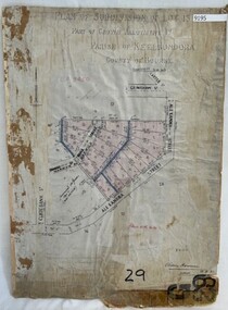 Greensborough Historical Society
Poster - Planning Document, City of Heidelberg, Subdivision Plan # G 29 Part 1, Crown allotment 17, Greensborough, 1922
Plan of Subdivisions in City of Heidelberg: Parish of Keelbundoora: Crown allotment 17 - Warwick Road, Clydbank Street, Alexandra Street, 1922.An example of hard copy subdivision plans from the Greensborough area. Mainly from the Shire of Diamond Valley era (1964-1994).Plan (single sided) mounted on heavy card. Stamped and handwritten Council permissions, dates and other details.subdivision plans, city of heidelberg -
 Ballarat Heritage Services
Image, Lisa Gervasoni Graduating from RMIT, c1990s
... planning ...Colour photograph of Lisa Gervasoni in academic regalia, after receiving her Bachelor of Applied Science (Planning) from RMIT at Dallas Brooks Hall.lisa gervasoni, rmit, planning, graduation, academic regalia -
Port Melbourne Historical & Preservation Society
Book, Making the Most of the Bay, Apr 1989
... Ministry for Planning and Environment ...'Making the Most of the Bay'- a draft plan for the protection and development of Port Phillip and Corio Bays, 1989. A draft plan to guide decision making. Introduction by Tom Roper, Minister for Planning and Development. (Refer item 1048, final version)state government victoria, natural environment, town planning -
 Kew Historical Society Inc
Plan, Melbourne & Metropolitan Board of Works : Borough of Kew : Detail Plan No.1561, 1905
The Melbourne and Metropolitan Board of Works (MMBW) plans were produced from the 1890s to the 1950s. They were crucial to the design and development of Melbourne's sewerage and drainage system. The plans, at a scale of 40 feet to 1 inch (1:480), provide a detailed historical record of Melbourne streetscapes and environmental features. Each plan covers one or two street blocks (roughly six streets), showing details of buildings, including garden layouts and ownership boundaries, and features such as laneways, drains, bridges, parks, municipal boundaries and other prominent landmarks as they existed at the time each plan was produced. (Source: State Library of Victoria). This plan forms part of a large group of MMBW plans and maps that was donated to the Society by Mr Poulter, City Engineer of the City of Kew in 1989. Within this collection, thirty-five hand-coloured plans, backed with linen, are of statewide significance as they include annotations that provide details of construction materials used in buildings in the first decade of the 20th century as well as additional information about land ownership and usage. The copies in the Public Record Office Victoria and the State Library of Victoria are monochrome versions which do not denote building materials so that the maps in this collection are invaluable and unique tools for researchers and heritage consultants. A number of the plans are not held in the collection of the State Library of Victoria so they have the additional attribute of rarity.Original survey plan, issued by the MMBW to a contractor with responsibility for constructing sewers in the area identified on the plan within the Borough of Kew. The plan was at some stage hand-coloured, possibly by the contractor, but more likely by officers working in the Engineering Department of the Borough and later Town, then City of Kew. The hand-coloured sections of buildings on the plan were used to denote masonry or brick constructions (pink), weatherboard constructions (yellow), and public buildings (grey). MMBW Detail Plan 1561 outlines those residences in the area bordered by Burke Road, Loxton Street, Mount Street and Barkers Road that had been constructed by 1905 when the land was surveyed. At this time, the area nearest Burke Road had been subdivided and developed whereas the lands to the west were as yet undeveloped. The houses represented are not named on the Plan.melbourne and metropolitan board of works, detail plans, mmbw 1561, cartography -
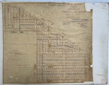 Greensborough Historical Society
Poster - Planning Document, City of Heidelberg, Subdivision Plan # 19 - Parish of Keelbundoora, Crown Portion 16, Watsonia "Black's subdivision', 1924
Subdivision Plan # 19 - Parish of Keelbundoora, Crown Portion 16, Watsonia "Black's subdivision". This subdivision plan includes proposed street names which were later changed (e.g. Morwell Street (not Morwell Avenue) now called Greenwood Drive). Includes Lambourn Road, Black Street, Grace Street, Eden Avenue, High Street, Kenmare Street, Morwell Avenue, Greensborough Road, Mundy Street, Ladd Street.An example of hard copy subdivision plans from the Greensborough area. Mainly from the Shire of Diamond Valley era (1964-1994).Plan (single sided) mounted on heavy card. Stamped and handwritten Council permissions, dates and other details. subdivision plans, city of heidelberg, greensborough, main street greensborough, shire of heidelberg, watsonia, black family -
 Kew Historical Society Inc
Plan, Melbourne and Metropolitan Board of Works, Borough of Kew : Detail Plan No.1562, 1905
The Melbourne and Metropolitan Board of Works (MMBW) plans were produced from the 1890s to the 1950s. They were crucial to the design and development of Melbourne's sewerage and drainage system. The plans, at a scale of 40 feet to 1 inch (1:480), provide a detailed historical record of Melbourne streetscapes and environmental features. Each plan covers one or two street blocks (roughly six streets), showing details of buildings, including garden layouts and ownership boundaries, and features such as laneways, drains, bridges, parks, municipal boundaries and other prominent landmarks as they existed at the time each plan was produced. (Source: State Library of Victoria). This plan forms part of a large group of MMBW plans and maps that was donated to the Society by the Mr Poulter, City Engineer of the City of Kew in 1989. Within this collection, thirty-five hand-coloured plans, backed with linen, are of statewide significance as they include annotations that provide details of construction materials used in buildings in the first decade of the 20th century as well as additional information about land ownership and usage. The copies in the Public Record Office Victoria and the State Library of Victoria are monochrome versions which do not denote building materials so that the maps in this collection are invaluable and unique tools for researchers and heritage consultants. A number of the plans are not held in the collection of the State Library of Victoria so they have the additional attribute of rarity.Original survey plan, issued by the MMBW to a contractor with responsibility for constructing sewers in the area identified on the plan within the Borough of Kew. The plan was at some stage hand-coloured, possibly by the contractor, but more likely by officers working in the Engineering Department of the Borough and later Town, then City of Kew. The hand-coloured sections of buildings on the plan were used to denote masonry or brick constructions (pink), weatherboard constructions (yellow), and public buildings (grey). MMBW detail plan No.1562, in contrast to No.1561 includes the names of a large number of houses: in Barkers Road: ‘Ashwick’, ‘Owasso’, ‘Anadiha’, ‘Eurobin’, ‘Carlsruhe’, ‘Arlington’ and ‘Altyre’. Unnamed but clearly represented on the plan is what was then known as the ‘Auburn Heights Recreation Club’, which at this stage included a Bowling Green, a Croquet Green and two Tennis Courts. On the plan, Brougham Place, as it was then known, is represented. It was later renamed Daniell Place. The aforementioned Arlington is now the junior campus of Preshil. melbourne and metropolitan board of works, detail plans, mmbw 1562, cartography -
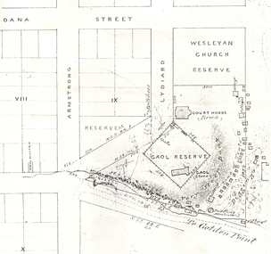 Federation University Historical Collection
Plan, Ballarat Showing Gaol Reserve, 1857, c1857
The portion of Lydiard Street depicted on this plan is now part of the Federation University Ballarat School of Mines (SMB) campus.Copy of an early plan of the former Ballarat Gaol Site.ballarat, ballarat gaol, ballarat gaol reserve, gaol reserve, ballarat courthouse, plan, gold diggings, smb campus, lydiard street south -
 Kew Historical Society Inc
Plan, Melbourne & Metropolitan Board of Works : Borough of Kew : Detail Plan No.1571, 1904
The Melbourne and Metropolitan Board of Works (MMBW) plans were produced from the 1890s to the 1950s. They were crucial to the design and development of Melbourne's sewerage and drainage system. The plans, at a scale of 40 feet to 1 inch (1:480), provide a detailed historical record of Melbourne streetscapes and environmental features. Each plan covers one or two street blocks (roughly six streets), showing details of buildings, including garden layouts and ownership boundaries, and features such as laneways, drains, bridges, parks, municipal boundaries and other prominent landmarks as they existed at the time each plan was produced. (Source: State Library of Victoria)This plan forms part of a large group of MMBW plans and maps that was donated to the Society by the Mr Poulter, City Engineer of the City of Kew in 1989. Within this collection, thirty-five hand-coloured plans, backed with linen, are of statewide significance as they include annotations that provide details of construction materials used in buildings in the first decade of the 20th century as well as additional information about land ownership and usage. The copies in the Public Record Office Victoria and the State Library of Victoria are monochrome versions which do not denote building materials so that the maps in this collection are invaluable and unique tools for researchers and heritage consultants. A number of the plans are not held in the collection of the State Library of Victoria so they have the additional attribute of rarity.Digital copy of the original survey plan, issued by the MMBW to a contractor with responsibility for constructing sewers in the area identified on the plan within the Borough of Kew. The plan was at some stage hand-coloured, possibly by the contractor, but more likely by officers working in the Engineering Department of the Borough and later Town, then City of Kew. The hand-coloured sections of buildings on the plan were used to denote masonry or brick constructions (pink), weatherboard constructions (yellow), and public buildings (grey). This plan is part of a large and historically significant group of MMBW plans and maps that was donated to the Society by the Mr Poulter, City Engineer of the City of Kew in 1989. When the contracts were let for surveyors to identify and record the extant houses and landscapes within an area for the Board of Works, the contracts were let at separate times, hence the anomaly where two copies of Plan No.1571 exist in our collection. The first of these plans identifies the building materials used in houses bordering Fitzwilliam Street, Edgevale Road, May Street, Malin Street, Davis Street and Wellington Street. The cut off point for the survey was the south side of Wellington Street. By 1903 when the survey was undertaken many of the sites were already built on, particularly those facing Edgevale Road. The plan identifies the preponderance of weatherboard houses in the area. The other version of the plan identifies the buildings between Wellington Street and Cotham Road.melbourne and metropolitan board of works, detail plans, mmbw 1571, cartography -
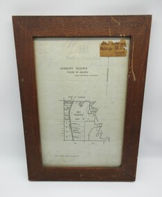 Hume City Civic Collection
Plans, SUNBURY RESERVE PARISH OF HOLDEN
This object is a plan of a proposed recreation ground at Munro's. This was unfenced land between Evans and Barkly Streets adjacent to the Asylum boundary, now Jacksons Hill.A wooden framed plan of a proposed recreation ground.sunbury, sunbury asylum, george evans collection -
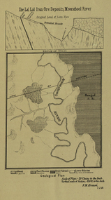 Federation University Historical Collection
Plan, Lal Lal Iron Ore Deposits, Moorabool River, 1881
This plan was printed in the Ballarat School of Mines Annual Report were Ferdinand Krause was a professor.Printed plan showing iron ore deposits at Lal Lal.lal lal ore, moorabool river, ferdinand krause -
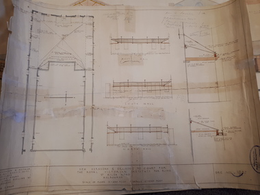
 Mission to Seafarers Victoria
Plan - Architectural drawings, Walter Butler, New Missions to Seamen Institute Buildings Melbourne, 1916
In August 1916, Walter R. Butler presented the plans for the future central Seamen's Institute.The drawings show the original plans with rooms' names and intended use. They also show the original concept for the chapel which was in the Spanish Mission style.Plan copied from the 1983 Howden and Wardrop A4 report. flinders street, mission to seamen, mission to seafarers, walter richmond butler (1864–1949), norla dome, st peter chapel, spanish mission, arts and crafts, 1916 -
 Mission to Seafarers Victoria
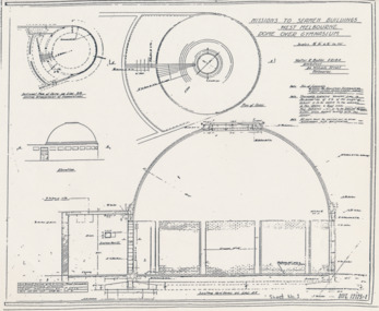
Plan - Architectural drawings, Walter Butler, Missions to Seamen Buildings, West Melbourne, Dome Over Gymnasium, 1916
In August 1916, Walter R. Butler presented the plans for the future central Seamen's Institute.The drawings show the original plans with rooms' names and intended use. They also show the original concept for the chapel which was in the Spanish Mission style.Plan copied from the 1983 Howden and Wardrop A4 report. flinders street, mission to seamen, mission to seafarers, walter richmond butler (1864–1949), norla dome, st peter chapel, spanish mission, arts and crafts, 1916 -
 Robin Boyd Foundation
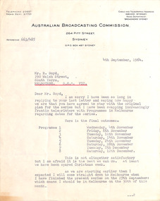
Letter, Australian Broadcasting Commission, John Worrall (ABC) to Robin Boyd, 04.09.1964
This letter, from John Worrall, Producer of University of the Air, thanks Robin Boyd for agreeing to stick with the original plan for the series and provides dates for the eight programs - from 4 November through to 12 December 1964. Australian design and not expanding it to world architecture. The letter also sets out what Robin needs to prepare in the preliminary stages.Two pages.Robin Boyd's handwriting and plan sketch in pencil on the reverse of second page. -
 Greensborough Historical Society
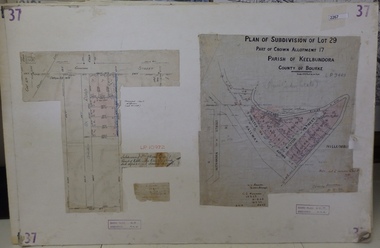
Planning Document, Subdivision Plan # 37. Poulter Avenue and Bicton Street; and, Adeline Street and Grimshaw Street Greensborough, 1971_
Plan of subdivision Lot 29, Part of Crown Allotment, Parish of Keelbundoora, County of Bourke. Poulter Avenue and Bicton Street; and, Adeline Street and Grimshaw Street.An example of hard copy subdivision plans from the Greensborough area. Mainly from the Shire of Diamond Valley era (1964-1994).Plan (2 sheets) mounted on heavy card. subdivision plans, grimshaw street, poulter avenue, adeline street -
 Greensborough Historical Society
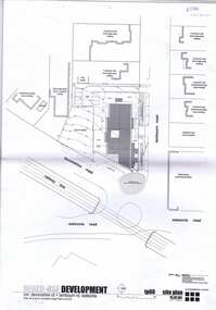
Plan, brucehenderson architects, Plans for proposed development at Devonshire and Lambourne Roads Watsonia 2004, 2004_01
Amended plans for a mixed use development corner Devonshire Road and Lambourn Road Watsonia in 2004.23 p., black & white and colour plans with covering letterwatsonia, lambourn road watsonia, devonshire road watsonia -
![Map, Plan of Town Allotments Bacchus Marsh [1891-1897]](/media/collectors/5e461d8021ea67224c82f2a1/items/66acc1c90c778f9f64a3daec/item-media/66acc3990c778f9f64a3e09b/item-fit-380x285.jpg) Bacchus Marsh & District Historical Society
Bacchus Marsh & District Historical SocietyMap, Plan of Town Allotments Bacchus Marsh [1891-1897]
This plan of town allotments in Lerderderg Street and Bennett Street also includes the location of many of the buildings, shops, businesses and houses which were present in the retail and business area of Bacchus Marsh in the 1890s. The precise date of the plan is not known but it must be sometime between 1891 and 1897. The Post Office and the Wesleyan Church are both shown on this plan. Both of these were constructed in 1890. The plan does not show the Baptist Church in Main Street which was constructed in 1898. Hence the date is sometime between 1891 and 1897.This plan of Bacchus Marsh is one of the most detailed visual representations of the location of shops, businesses and houses in the central part of Bacchus Marsh. It provides very precise locations of most of the shops and houses in the town in the 1890s. A single page paper plan showing allotments of land fronting Lerderderg and Bennett Street. Buildings, businesses and houses along most of the streets are identified by hand written annotations. Streets identified on plan: Lerderderg Street - Bennett Street - Main Street - Gell Street - Young Street - Graham Street. Physical boundaries of the map are: North border - Lerderderg Street - South border - Main Street - West border Gell Street - East border - Young Street. The plan is pasted into a bound volume containing 76 maps or plans in total. bacchus marsh victoria maps, shops bacchus marsh -
Clunes Museum
Map, Surface Geology Plan
Plans show various shaft locations.1 Photocopy of Plan Block 23/19 Scale 1 inch = 100 feet .2 Photocopy of Plan Block 19/19 Scale 1 inch = 100 feet .3 AERIAL PHOTOGRAPH WITH WORKINGS MARKED - LAMINATED.1 C-21 North Broken Hill Ltd Clunes Block 23/19 .2SOUTH CLUNES MINE Ltd Clunes Block 19/19north broken hill ltd, surface geology plan -
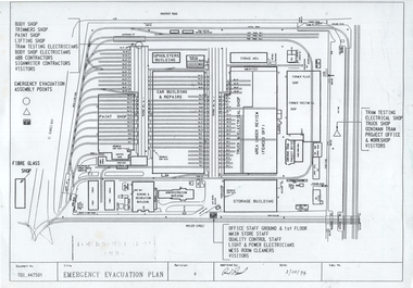 Melbourne Tram Museum
Document - Preston Workshops, Public Transport Corporation (PTC), Emergency Evacuation Plan", Oct. 1994
Plan dated 3/10/1994 shows the layout of the Preston Workshops tracks, buildings at the time and emergency evacuation assembly points. At the time operated by the Public Transport Corporation with ABB Contractors and Goninan Tram Project Offices. Document Number T01_447501.Yields information about the layout of Preston Workshops in 1994.Photocopy of an A4 plan or document.tramways, trams, preston workshops, floor plans, track plans -
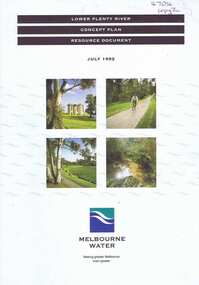 Greensborough Historical Society
Book, Lower Plenty River concept plan: resource document, 1992_07
Draft concept plan prepared by Brett Cheatley, Malcolm Warren and Ian Womersley, Parks and Waterways Planning Division, Melbourne Water. This document includes information on the heritage and environment of the Lower Plenty River.Book, mainly black and white, colour photographs and plans, 56 pages, 3 copies.plenty river, melbourne water, lower plenty river -
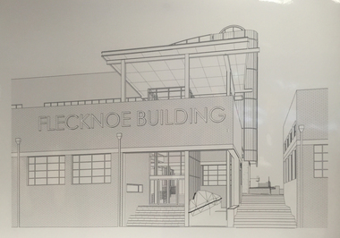 Federation University Historical Collection
Plan, Flecknoe Building Refurbishment Plans, 2017
Plans that were on display for opening of the refurnbished Flecknoe BuildingThree images of plans for the refurbishment of the Flecknoe Building at the Federation University SMB Building.ballarat school of mines, flecknoe builiding, refurbishment, buildings