Showing 1432 items
matching planning development
-
 Greensborough Historical Society
Document collection, Banyule City Council, Watermarc, Greensborough, 2004-2012
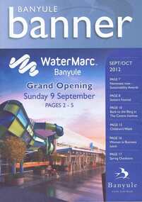
The development of the Greensborough town centre and in particular the redevelopment of the Greensborough Pool into the Watermarc aquatic centre is documented in this collection of minutes, correspondence, plans, brochures, etc. Contents: Box 1, Correspondence, Project updates, Leaflets, Plans, Newspaper articles. Community Consultative Committee meetings - Agendas and Minutes. Box 2: Greensborough Project Presentation Package 2006; Greensborough principal activity centre plan (executive summary 2005, 2008); Consultation documents 2005; Banyule Banner (2005; 2006); Project update 2005; Newspaper article collection; Advertising leafletsThis collection is significant as it covers the development of the pool precinct from concept plan to completed complex.A collection of various documents relating to the development of the Watermarc pool complex. Includes leaflets, plans, minutes of committee meetings and letters to committee member (in black ring binder).watermarc, greensborough, greensborough pool, swimming pools, rosalie bray, banyule city council -
 Greensborough Historical Society
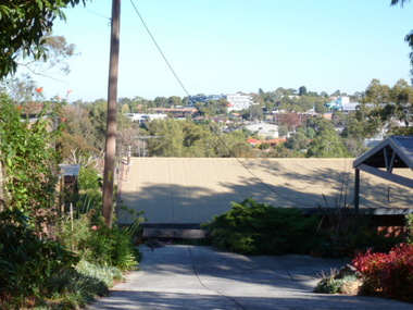
Photograph - Digital image, View of Greensborough from Delfin Crescent, 02/05/2013
This photograph of Greensborough was taken from Delfin Crescent in 2013 to show changes over 40 years, based on Ron Reynold’s sketches in the 1973 publication “Greensborough and Greenhills” published by Cypress Books. Delphin Crescent [previously known as Medhurst Street] was created about 1970 in association with the Delfin Building Company. It was at this time also, that major works on Diamond Creek Road raised the level of the road facilitating the connection of Delfin Crescent with Diamond Creek Road. [Note: 'Medhurst Street was only listed on planning maps pre 1950 when the 'street' had no residents or development.]Digital copy of colour photograph.greensborough and greenhills -
 Greensborough Historical Society
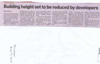
Newspaper clipping, Building height set to be reduced by developers, 17/06/2015
A proposed development at 4-6 Flintoff Street is to have its plans amended to reduce the height of the building.News clipping, black text.flintoff street greensborough, town planning, banyule city council -
 Greensborough Historical Society
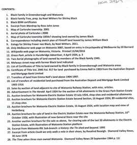
Folder of documents, Black Family in Greensborough and Watsonia, 1924o
Collection of copies of documents and plans relating to land owned by the Black Family in Greensborough and Watsonia, and its sale by auction and subdivision to form the suburb of Watsonia following the building of Watsonia Railway Station in 1924History of the development of the suburb of WatsoniaLoose-leaf folder, pages in file protectorsblack family, watsonia -
 Greensborough Historical Society
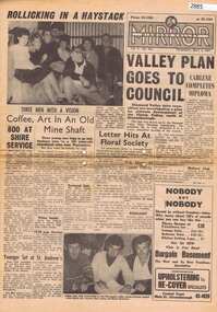
Newspaper, Elliott Provincial newspapers Pty Ltd, Diamond Valley Mirror May 4, 1965, 04/05/1965
Contains article "Valley plan goes to Council", discussing the development of the Plenty Valley, north of Greensborough.Early plan submitted to Diamond Valley Council in 19658 p.greensborough -
 Greensborough Historical Society
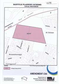
Map, Saxam Heritage Overlay, 2011_
"Saxam" was the home of the Kaye family (1886-1888) then William Santon, a former councillor and Mayor of Heidelberg. Saxam Homestead is a distinctive and substantial timber homestead built in the late 1880s as one of the notable rural properties in the St Helena area. In 2014 the house still stands but is in poor condition with most interior features removed. The site had a heritage overlay as shown. The overlay was reduced in 2014 to protect the house while allowing residential development on the site.Saxam is one of the only remaining farmhouses in the Greensborough area.Copy of map and planning scheme.saxam -
![Document, Town Planning Appeals Tribunal, Town Planning Appeals Tribunal report 1978 [Loyola College], 06/11/1978](/media/collectors/4f729f5697f83e03086015b8/items/58bbb237d0cdef1bcc864955/item-media/58bbb35fd0cdef1bcc8683be/item-fit-380x285.jpg) Greensborough Historical Society
Greensborough Historical SocietyDocument, Town Planning Appeals Tribunal, Town Planning Appeals Tribunal report 1978 [Loyola College], 06/11/1978
Report on an appeal against two conditions on the development of land in Grimshaw Street Watsonia for a secondary school [Loyola College].This document demonstrates some of the problems associated with setting up a school in a residential area.3 pages, torn and yellowed.loyola college -
 Greensborough Historical Society
Plan, Plan of Manatunga Circuit Greensborough subdivision, 1970_
... Plan of Manatunga Circuit subdivision. Prepared by O'Connor...) for Development Underwriting (developers). Plan of subdivision. Part ...Plan of Manatunga Circuit subdivision. Prepared by O'Connor and Beveridge (land surveyors) for Development Underwriting (developers). Plan of subdivision. Part of Crown Portion 3. Parish of Nillumbik, County of Evelyn.An original example of a subdivision plan in the expanding suburb of Greensborough. The 1960s and 1970s saw this area develop from a rural farming area to a suburb.Plan of subdivision. Printed on buff paper, hand coloured. Mounted on cardboard. Includes 2 small cards attached.Various handwritten comments. Small cards from Survey Branch, Office of Titles.greensborough, manatunga circuit, diamond creek road, plenty river drive -
 Greensborough Historical Society
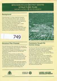
Pamphlet, Shire of Diamond Valley, Greensborough District Centre, Structure Plan, 1988_
... as it was in 1988 and 4 concept plans for the proposed development ...This was issued in 1988 calling for comments regarding the proposed development of the Greensborough Centre in 1988.This pamphlet has pictures of Greensborough as it was in 1988 and 4 concept plans for the proposed development.A 6 page folded pamphlet with green print on a glossy yellow paper.Nilgreensborough centre, 1988, diamond valley shire, lend lease -
 Greensborough Historical Society
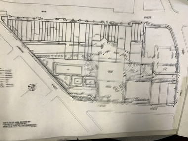
Planning Document, Banyule City Council, Site plan of Greensborough 1997, 28/07/1997
... Greensborough. these plans show the area before the development ...Site plans for the area bounded by Flintoff Street; Grimshaw Street; Main Street and Para Road Greensborough. these plans show the area before the development of Watermarc.This plan shows central Greensborough before the Watermarc developmentSet of 8 site plansgreensborough, greensborough swimming pool -
 Greensborough Historical Society
Newspaper Clipping, Subdivision tax set to bite, 13/09/2017
... subdivision plans land development banyule city council News article 1 ...Mum and dad developers face being slugged with an extra tax to subdivide their properties.News article 1 page, black text.tax, subdivision plans, land development, banyule city council -
 Greensborough Historical Society
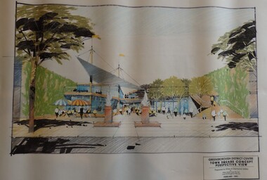
Planning Document, Shire of Diamond Valley, Greensborough District Centre, Town Square Concept Plans 1991, 1991_02
Plans and concept drawings for the proposed development of the Greensborough District Centre, Town Square. Shire of Diamond Valley existed from 1964 to 1994.7 plans and 2 concept drawings, black and coloured ink on white paper.shire of diamond valley, greensborough -
 Greensborough Historical Society
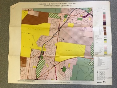
Map, Melbourne and Metropolitan Board of Works Interim Development Order 1961 Map No. 53, 27/09/1961
Denotes Zones and Reservations comprising part of the municipalities of Eltham, Heidelberg, Preston and Whittlesea, approved 27.9.61. Includes Mont Park Hospital and Watsonia Military Camp.Colour plan Date printed on plan (1959) has been over stamped with 1961. Also stamped with Government Gazette date of 27.9.1961. "Scale 800 feet to 1 inch"greensborough, watsonia -
 Greensborough Historical Society
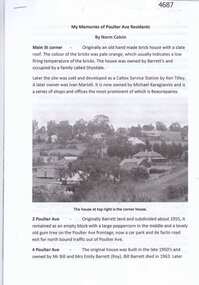
Article, Norm Colvin, My memories of Poulter Ave residents, by Norm Colvin, 28/07/2016
Details of the development and occupation of sites in Poulter Avenue and Bicton Street Greensborough, compiled by resident Norm Colvin.12 pages, text, black and white photographs and colour subdivision plan.poulter avenue greensborough, bicton street greensborough -
 Glenelg Shire Council Cultural Collection
Plan - Impression of the ultimate development of the Port of Portland, Ultimate Development of the Port of Portland, c. 1960
Donor's father was Shire Secretary at Hawkesdale and attended the opening of the Port.Impression of the ultimate development of the Port of Portland. Colour image on heavy, shiny white paper, white border round image. Folded in half.Front: 'Impression of Ultimate Development of the Port of Portland' - Printed in black, beneath colour image.port of portland -
 Eltham District Historical Society Inc
Photograph, Liz Pidgeon, Heritage Excursion; The 1901 Eltham Railway Walk, 3 May 2014, 3 May 2014
Newsletter No. 216, May 2014 May Excursion – The 1901 Eltham Railway Walk The railway from Heidelberg to Eltham was opened in 1902. Over the previous year railway construction cut a curving swathe through Josiah Holloway’s 1851 Little Eltham subdivision. The survey plans for the railway show the owners and occupiers of land within Little Eltham affected by the railway alignment and for some distance each side. The plans show houses and other buildings but development at that time was rather sparse. Copies of these plans from the State Library of Victoria collection have been provided to the Society by Alan Sheehan. For our walk on 3rd May we intend to follow the railway from the Eltham Station to Ryans Road, which was the boundary of the adjoining Montmorency Farm. The return will be by way of nearby streets. Along the way we will discuss the details shown on the railway plans as well as more recent railway documents and photographs. At the conclusion and if time permits we can inspect the historical display at the Eltham Station. The walk is about 3 km in length and will take about 2.5 hours. It will start at 2 pm at the Eltham Railway Station car park (east/Main Road side) (Melway Ref. 21 J5).Born Digitalheritage excursion, activities, eltham district historical society, eltham railway station, eltham library, trestle bridge -
 Eltham District Historical Society Inc
Photograph, Liz Pidgeon, Heritage Excursion; The 1901 Eltham Railway Walk, 3 May 2014, 3 May 2014
Football match at Eltham Central Park between Eltham and Heidelberg Newsletter No. 216, May 2014 May Excursion – The 1901 Eltham Railway Walk The railway from Heidelberg to Eltham was opened in 1902. Over the previous year railway construction cut a curving swathe through Josiah Holloway’s 1851 Little Eltham subdivision. The survey plans for the railway show the owners and occupiers of land within Little Eltham affected by the railway alignment and for some distance each side. The plans show houses and other buildings but development at that time was rather sparse. Copies of these plans from the State Library of Victoria collection have been provided to the Society by Alan Sheehan. For our walk on 3rd May we intend to follow the railway from the Eltham Station to Ryans Road, which was the boundary of the adjoining Montmorency Farm. The return will be by way of nearby streets. Along the way we will discuss the details shown on the railway plans as well as more recent railway documents and photographs. At the conclusion and if time permits we can inspect the historical display at the Eltham Station. The walk is about 3 km in length and will take about 2.5 hours. It will start at 2 pm at the Eltham Railway Station car park (east/Main Road side) (Melway Ref. 21 J5).Born Digitalheritage excursion, activities, eltham district historical society, eltham railway station, eltham library, trestle bridge, eltham central park, football -
 Eltham District Historical Society Inc
Photograph, Liz Pidgeon, Heritage Excursion; The 1901 Eltham Railway Walk, 3 May 2014, 3 May 2014
Newsletter No. 216, May 2014 May Excursion – The 1901 Eltham Railway Walk The railway from Heidelberg to Eltham was opened in 1902. Over the previous year railway construction cut a curving swathe through Josiah Holloway’s 1851 Little Eltham subdivision. The survey plans for the railway show the owners and occupiers of land within Little Eltham affected by the railway alignment and for some distance each side. The plans show houses and other buildings but development at that time was rather sparse. Copies of these plans from the State Library of Victoria collection have been provided to the Society by Alan Sheehan. For our walk on 3rd May we intend to follow the railway from the Eltham Station to Ryans Road, which was the boundary of the adjoining Montmorency Farm. The return will be by way of nearby streets. Along the way we will discuss the details shown on the railway plans as well as more recent railway documents and photographs. At the conclusion and if time permits we can inspect the historical display at the Eltham Station. The walk is about 3 km in length and will take about 2.5 hours. It will start at 2 pm at the Eltham Railway Station car park (east/Main Road side) (Melway Ref. 21 J5).Born Digitalheritage excursion, activities, eltham district historical society, eltham railway station, eltham library, trestle bridge -
 Eltham District Historical Society Inc
Photograph, Liz Pidgeon, Heritage Excursion; The 1901 Eltham Railway Walk, 3 May 2014, 3 May 2014
Newsletter No. 216, May 2014 May Excursion – The 1901 Eltham Railway Walk The railway from Heidelberg to Eltham was opened in 1902. Over the previous year railway construction cut a curving swathe through Josiah Holloway’s 1851 Little Eltham subdivision. The survey plans for the railway show the owners and occupiers of land within Little Eltham affected by the railway alignment and for some distance each side. The plans show houses and other buildings but development at that time was rather sparse. Copies of these plans from the State Library of Victoria collection have been provided to the Society by Alan Sheehan. For our walk on 3rd May we intend to follow the railway from the Eltham Station to Ryans Road, which was the boundary of the adjoining Montmorency Farm. The return will be by way of nearby streets. Along the way we will discuss the details shown on the railway plans as well as more recent railway documents and photographs. At the conclusion and if time permits we can inspect the historical display at the Eltham Station. The walk is about 3 km in length and will take about 2.5 hours. It will start at 2 pm at the Eltham Railway Station car park (east/Main Road side) (Melway Ref. 21 J5).Born Digitalheritage excursion, activities, eltham district historical society, eltham railway station, eltham library, trestle bridge