Showing 596 items matching "railway station buildings"
-
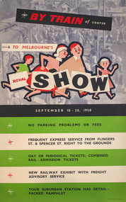 Melbourne Royal
Poster, W. M. Houston, By train of course, to Melbourne's Royal Show, 1958
A poster promoting the merits of travelling by train to the Royal Melbourne Show of 1958. The Showgrounds train station was one of the first buildings built on the Melbourne Showgrounds in Ascot Vale when the site was established in 1883, allowing patrons quick access to the venue despite it being slightly further out from the city than previous sites.A portrait poster, printed in colour; in the upper half of the poster there is an illustration showing a family of four, walking to the right; in the background is a photograph of a train station; the lower half of the poster consists of a list of the advantages of taking the train, printed on five horizontal stripes, white and green; colour process lithograph, linen-backed.BY TRAIN of course / TO MELBOURNE'S / ROYAL SHOW / SEPTEMBER 18 - 28, 1958/ NO PARKIGN PROBLEMS OR FEES / FREQUENT EXPRES SERVICE FROM FLINDERS ST. & SPENCER ST. RIGHT TO THE GROUNDS / DAY OR PERIODICAL TICKETS; COMBINED RAIL-ADMISSION TICKETS / NEW RAILWAY EXHBIIT WITH FREIGHT ADVISORY SERVICE / YOUR SUBURBAN STATION AHS DETAIL-PACKED PAHMPHLET /train, metro trains, showgrounds, melbourne showgrounds, royal melbourne show, 1985 melbourne royal show, melbourne royal show, showgrounds station, railway -
 Melbourne Tram Museum
Photograph - Black and white - Glenferrie Road, Glenferrie c1915
Shows Glenferrie Road, near Linda St looking south, c1915 prior to the construction of the Railway overpass at Glenferrie Railway Station with H class tram 58 in the view. The tram line was constructed in 1913. It would appear that the level crossing gates are closed in the photograph. The building on the right-hand side by the horse-drawn cart was an ANZ bank until 2021. The closer building, a theatre (The Palace) has since been demolished and is now a Coles Supermarket. The level crossing was replaced with an overbridge in April 1916. The church in the background is the Immaculate Conception Church, without the spires - built after WW1. Yields information about the location, the streetscape and the tram, vehicles in use at the time. Black and white photograph of Glenferrie Road Glenferrie with tram H58, looking south near Linda St, c1915."RSCP 327" & "C1920s" in pencil on rear and H58 in red ink.tramways, trams, glenferrie road, hawthorn, streetscapes, h class, tram 58 -
 Melbourne Tram Museum
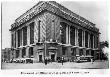
Photograph - Black and White - Mail Exchange Spencer and Bourke Streets c1920
Photo of the Mail Exchange Building with a cable tram loading prior to departure and a number of motor vehicles. The photo shows the monumental construction for the then Post Master Generals Department. This building was completed in 1917 to replace the mail sorting functions of the GPO on the corner of Bourke and Elizabeth St. It had tunnels that connected with Spencer Street Railway station opposite and was designed for the sorting and transporting of mail.Yields information about the Mail Exchange building.Photograph - Black and White - Mail Exchange Spencer and Bourke Streets c1920tramways, trams, cable cars, bourke street, spencer street, post office, post master general, mail exchange -
 Melbourne Tram Museum
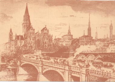
Artwork, other, Princes Bridge from the south bank of the Yarra River, c1900
Sepia toned print of a drawing of Princes Bridge with St Paul's Cathedral and other buildings. Has a number of cable trams and horse drawn vehicles on the bridge. The artist has taken liberties and drawn the spires onto St Paul's cathedral and other buildings such as Princes Bridge railway station. The spires is most likely based on the proposed design at the time. They were built in 1926 to a changed design - see reference.Yields information about the Princes Bridge precinct.Reproduction of a Lithograph drawing - Princes Bridge from the south bank of the Yarra River.melbourne, princes bridge, horse drawn vehicles, st pauls cathedral, cable trams -
 Melbourne Tram Museum
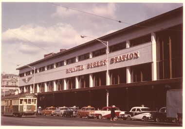
Photograph - Spencer St Station and W2 536, c1962
Photo shows the new Spencer St station which was completed around 1962 with tram W2 430 (Spencer St, Route 48), fitted with large trolley bridges, northbound to the terminus at Latrobe St. Eight taxis are lined up at the taxi stand, mostly Holdens with at least one Ford.Yields information about the Spencer Station building when new and the taxis serving the station.Colour print - satin finish print - Spencer St Station and W2 536 c1962railways, victorian railways, spencer st, spencer st station, taxis, w2 class, tram 536 -
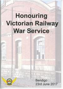 Bendigo Historical Society Inc.
Magazine - HONOURING VICTORIAN RAILWAY WAR SERVICE - BENDIGO 23 JUNE 2017
Sandhurst Railway station opened in October 1862 and was renamed Bendigo in 1891. The current station was built in 1965 and has had extensive refurbishments since then, including in 1984 and 1988.Magazine publication with coloured photograph of Bendigo Railway Station on front and back cover. Contains 50 pages of biographies of those locomotive drivers who served in World War I. Also contains photographs of people, war service records, newspaper articles and buildings.Rail Tram ande Bus Union - Locomotive Division Victoria -
 Federation University Historical Collection
Booklet - Walking Guide, Ballarat Heritage Walking Guide, c2015
35 page booklet with a detail from the Mining Exchange on the front. ballarat, walking trail, statues, gold monument, sturt street, unicorn hotel, ballarat town hall, sugg light, ballarat post office, camp street, summerscales building, state offices, police court, huyghue house, pratt's building, ymca, ballarat trades hall, ana hall, maps, lydiard street, ballarat gaol, ballarat school of mines, wesleyan church, ansonia, lynn's chambers, craig's royal hotel, her majesty's theatre, union bank building, bank of australasia, national bank, colonial bank of australasia, bank of new south wales, george hotel, old colonists' hall, art gallery of ballarat, union fidelity hall, goller's warehouse, dunn's warehouse, ludbrook house, reid's coffe police, ballarat railway station, cenotaph, queen victoria fountain, boer war memorial, burke and wills founitain, titanic memorial bandstand -
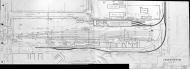 Melbourne Tram Museum
Drawing, Victorian Railways (VR), "Sandringham" - Plan No. R17384, July 1940
Drawing - Victorian Railways R17384 showing Sandringham Railway station yard, facilities, tram depot, tram tracks, railway tracks, buildings, drains, poles, adjacent streets and buildings. Dated July 1940. The tram tracks have been inked in on the print.Yields information about issues Sandringham depot and its tram tracks.Drawing - photocopy of original- two parts joined in the centre by adhesive tape.trams, railways, vr trams, sandringham, tram tracks, depot, sandringham depot -
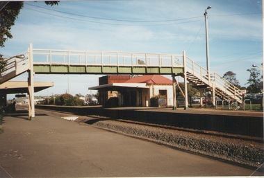 Sunbury Family History and Heritage Society Inc.
Photograph, Elwyn Davis, Pedestrian Bridge, C1990s
The wooden pedestrian bridge spanned the rail tracks at Sunbury Railway Station and were replaced with a more modern bridge and ramp when upgrades were done at the station and along the Bendigo line in the late 1990s and early 2000s. The water tank beyond the station building was used to refill the engines with water when steam engines were used. Diesel driven V Line trains now convey commuters from the regional towns along the Bendigo region to Melbourne.The Bendigo Line was the first government rail line to open and it reached Sunbury in 1859. It was extended to Bendigo and opened in 1861.A non-digital coloured photograph of a wooden pedestrian bridge spanning rail tracks with a wooden station building and former water tower on the station platform. rail bridges, bendigo rail line, sunbury station, water towers, railways -
Clunes Museum
Book, CREATIVE CLUNES, COMMUNITY USE OF VACANT RAIL BHILDINGS PROGRAM CLUNES RAILWAY STATION 2015, 2015
... BUILDINGS (CUVRB) PROGRAM TO REFURSHIS THE CLUNES RAILWAY STATION ...MARKING THE COMPLETION OF THE $580,000 COMUNITY USE OF VACANT RAIL BUILDINGS (CUVRB) PROGRAM TO REFURSHIS THE CLUNES RAILWAY STATION BUILDING AS A COMMUNITY BASED CULTURAL HUB WHICH WILL PROVIDE A PERMANENT HOME FOR THE CLUNES BOOKTOWN FESTIVAL AND EVENTS AND PROVIDE OFFICE AND MEETING SPACE FOR THE COMMUNITY.HARDCOVER BOOK WITH COLOUR IMAGES OF THE RAILWAY SATION BUILDNG ON THE FRONT AND BACK COVERS MARKING THE COMPLETION OF THE $580,000 COMUNITY USE OF VACANT RAIL BUILDINGS (CUVRB) PROGRAM TO REFURSHIS THE CLUNES RAILWAY STATION BUILDING AS A COMMUNITY BASED CULTURAL HUB WHICH WILL PROVIDE A PERMANENT HOME FOR THE CLUNES BOOKTOWN FESTIVAL AND EVENTS AND PROVIDE OFFICE AND MEETING SPACE FOR THE COMMUNITY.clunes railway station, restoration, clunes booktown hub -
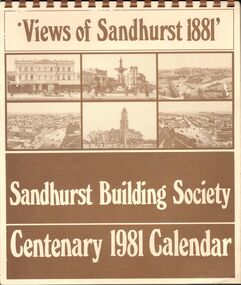 Bendigo Historical Society Inc.
Document - SANDHURST BUILDING SOCIETY CENTENARY 1981 CALENDAR
Buff Paper, Sepia Text & Illustrations 7 Pages Views of Sandhurst 1881 Calendar Images: Beehive Chambers and Mining Exchange Hotel, Pall Mall; panorama from Post Office Tower looking north to White Hills; Sandhurst Post Office Pall Mall; Sandhurst Railway Station (opened 1862) and Quarry Hill;Alexandra Fountain, Charing Cross, (opened 1881); panorama from Post Office Tower looking south to Golden Square.bendigo, history, sandhurst building society calendar -
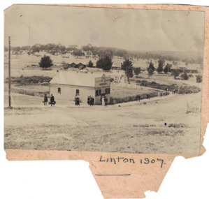 Linton and District Historical Society Inc
Photograph, Grenville Standard Newspaper Office, Linton 1907
Black and white image of people walking past a building in the main street of Linton. Early LDHS index to photographs says that the people walking along Clyde Street were "probably [in Linton] for Highland sports". Image has been glued to a piece of backing paper.newspapers, printers, railway stations -
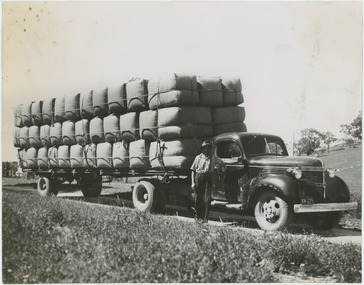 National Wool Museum
Photograph - Transporting Wool, 1960s
One of fifty one photographs originally in a photo album found in the National Wool Museum’s office. The album was water damaged and the images were removed for conservation. The images follow the process of wool. Beginning in a sheep paddock and finishing as a folded fabric. It includes all the steps in between in this process, including shearing, transporting, selling, washing and the many different steps in the process of turning a single thread of wool into fabric.Black and white image showing a man standing in front of a truck loaded with wool bales. The bales are being transported from Boorowa to Sydney.AUSTRALIAN NATIONAL PUBLICITY / ASSOCIATION / FLINDERS STREET RAILWAY BUILDING, / MELBOURNE AUSTRALIA / W40. Seventy bales of Wool going by motor vehicle from Boorowa to / Sydney.wool industry, working life, women, boonoke station, farming, sheep farming, agriculture, sheep stations, transport, wool processing, shearing, textile industry, wool -
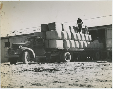 National Wool Museum
Photograph - Loading Wool Bales, 1960s
One of fifty one photographs originally in a photo album found in the National Wool Museum’s office. The album was water damaged and the images were removed for conservation. The images follow the process of wool. Beginning in a sheep paddock and finishing as a folded fabric. It includes all the steps in between in this process, including shearing, transporting, selling, washing and the many different steps in the process of turning a single thread of wool into fabric.Black and white image showing two men loading wool bales onto a motor transport vehicle.AUSTRALIAN NATIONAL PUBLICITY / ASSOCIATION / FLINDERS STREET RAILWAY BUILDING, / MELBOURNE AUSTRALIA / W68 / W68. Loading wool bales on to / a motor transport.wool industry, working life, women, boonoke station, farming, sheep farming, agriculture, sheep stations, transport, wool processing, shearing, textile industry, wool -
 National Wool Museum
Photograph - Wheeling Away for Dispatch, 1960s
One of fifty one photographs originally in a photo album found in the National Wool Museum’s office. The album was water damaged and the images were removed for conservation. The images follow the process of wool. Beginning in a sheep paddock and finishing as a folded fabric. It includes all the steps in between in this process, including shearing, transporting, selling, washing and the many different steps in the process of turning a single thread of wool into fabric.Black and white image showing a man with a wool bale on a trolley.AUSTRALIAN NATIONAL PUBLICITY / ASSOCIATION / FLINDERS STREET RAILWAY BUILDING, / MELBOURNE AUSTRALIA / W8 / W8. Wheeling away for despatch.wool industry, working life, women, boonoke station, farming, sheep farming, agriculture, sheep stations, transport, wool processing, shearing, textile industry, wool -
 National Wool Museum
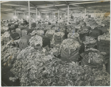
Photograph - Wool Displayed, 1960s
One of fifty one photographs originally in a photo album found in the National Wool Museum’s office. The album was water damaged and the images were removed for conservation. The images follow the process of wool. Beginning in a sheep paddock and finishing as a folded fabric. It includes all the steps in between in this process, including shearing, transporting, selling, washing and the many different steps in the process of turning a single thread of wool into fabric.Black and white image showing interior view of wool bales on display.AUSTRALIAN NATIONAL PUBLICITY / ASSOCIATION / FLINDERS STREET RAILWAY BUILDING, / MELBOURNE AUSTRALIA / W1 / W1. Wool displayed.wool industry, working life, women, boonoke station, farming, sheep farming, agriculture, sheep stations, transport, wool processing, shearing, textile industry, wool -
 National Wool Museum
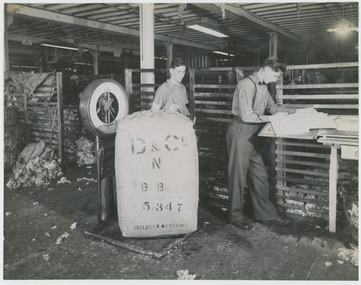
Photograph - Weighing Bales, 1960s
One of fifty one photographs originally in a photo album found in the National Wool Museum’s office. The album was water damaged and the images were removed for conservation. The images follow the process of wool. Beginning in a sheep paddock and finishing as a folded fabric. It includes all the steps in between in this process, including shearing, transporting, selling, washing and the many different steps in the process of turning a single thread of wool into fabric.Black and white image showing two men weighing a bale of wool.AUSTRALIAN NATIONAL PUBLICITY / ASSOCIATION / FLINDERS STREET RAILWAY BUILDING, / MELBOURNE AUSTRALIA / W5 / W5. Weighing bales.wool industry, working life, women, boonoke station, farming, sheep farming, agriculture, sheep stations, transport, wool processing, shearing, textile industry, wool -
 National Wool Museum
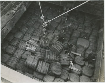
Photograph - Wool Bales Stored on a Ship, 1960s
One of fifty one photographs originally in a photo album found in the National Wool Museum’s office. The album was water damaged and the images were removed for conservation. The images follow the process of wool. Beginning in a sheep paddock and finishing as a folded fabric. It includes all the steps in between in this process, including shearing, transporting, selling, washing and the many different steps in the process of turning a single thread of wool into fabric.Black and white image showing bales of wool stored in the hold of a ship. Three men are standing amongst the bales.AUSTRALIAN NATIONAL PUBLICITY / ASSOCIATION / FLINDERS STREET RAILWAY BUILDING, / MELBOURNE AUSTRALIA / W42. Looking down into the hold of a / ship where the bales are stored / for transport overseas.wool industry, working life, women, boonoke station, farming, sheep farming, agriculture, sheep stations, transport, wool processing, shearing, textile industry, wool -
 National Wool Museum
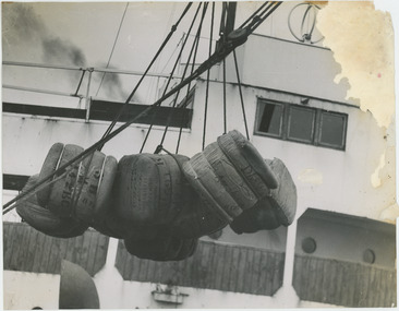
Photograph - Loading Wool Bales on to a Ship, 1960s
One of fifty one photographs originally in a photo album found in the National Wool Museum’s office. The album was water damaged and the images were removed for conservation. The images follow the process of wool. Beginning in a sheep paddock and finishing as a folded fabric. It includes all the steps in between in this process, including shearing, transporting, selling, washing and the many different steps in the process of turning a single thread of wool into fabric.Black and white image showing bales of wool being loaded onto a ship.AUSTRALIAN NATIONAL PUBLICITY / ASSOCIATION / FLINDERS STREET RAILWAY BUILDING, / MELBOURNE AUSTRALIA / W41 Loading bales of wool on to / a ship for transport overseas.wool industry, working life, women, boonoke station, farming, sheep farming, agriculture, sheep stations, transport, wool processing, shearing, textile industry, wool -
 National Wool Museum
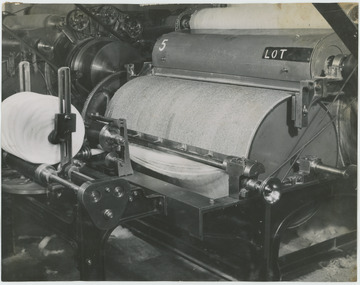
Photograph - Carding Machine, 1960s
One of fifty one photographs originally in a photo album found in the National Wool Museum’s office. The album was water damaged and the images were removed for conservation. The images follow the process of wool. Beginning in a sheep paddock and finishing as a folded fabric. It includes all the steps in between in this process, including shearing, transporting, selling, washing and the many different steps in the process of turning a single thread of wool into fabric.Black and white image showing detail view of a carding machine.AUSTRALIAN NATIONAL PUBLICITY / ASSOCIATION / FLINDERS STREET RAILWAY BUILDING, / MELBOURNE AUSTRALIA / W13 / W13. Close-up of Carding.wool industry, working life, women, boonoke station, farming, sheep farming, agriculture, sheep stations, transport, wool processing, shearing, textile industry, wool -
 National Wool Museum
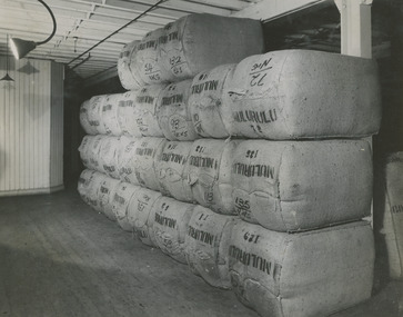
Photograph - Wool Bales in Storage, 1960s
One of fifty one photographs originally in a photo album found in the National Wool Museum’s office. The album was water damaged and the images were removed for conservation. The images follow the process of wool. Beginning in a sheep paddock and finishing as a folded fabric. It includes all the steps in between in this process, including shearing, transporting, selling, washing and the many different steps in the process of turning a single thread of wool into fabric.Black and white image showing bales of wool in storage.AUSTRALIAN NATIONAL PUBLICITY / ASSOCIATION / FLINDERS STREET RAILWAY BUILDING, / MELBOURNE AUSTRALIA / W6 / W6. Bulk storage.wool industry, working life, women, boonoke station, farming, sheep farming, agriculture, sheep stations, transport, wool processing, shearing, textile industry, wool -
 National Wool Museum
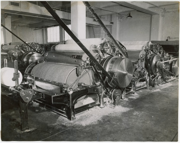
Photograph - Carding Machine, 1960s
One of fifty one photographs originally in a photo album found in the National Wool Museum’s office. The album was water damaged and the images were removed for conservation. The images follow the process of wool. Beginning in a sheep paddock and finishing as a folded fabric. It includes all the steps in between in this process, including shearing, transporting, selling, washing and the many different steps in the process of turning a single thread of wool into fabric.Black and white image showing a carding machine.AUSTRALIAN NATIONAL PUBLICITY / ASSOCIATION / FLINDERS STREET RAILWAY BUILDING, / MELBOURNE AUSTRALIA / W14 / W14, Carding Machine.wool industry, working life, women, boonoke station, farming, sheep farming, agriculture, sheep stations, transport, wool processing, shearing, textile industry, wool -
 National Wool Museum
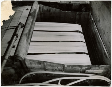
Photograph - Scouring Cloth, 1960s
One of fifty one photographs originally in a photo album found in the National Wool Museum’s office. The album was water damaged and the images were removed for conservation. The images follow the process of wool. Beginning in a sheep paddock and finishing as a folded fabric. It includes all the steps in between in this process, including shearing, transporting, selling, washing and the many different steps in the process of turning a single thread of wool into fabric.Black and white image showing a scouring machine with cloth.AUSTRALIAN NATIONAL PUBLICITY / ASSOCIATION / FLINDERS STREET RAILWAY BUILDING, / MELBOURNE AUSTRALIA / W27 / W27. Scouring cloth preparatory to Dyeing.wool industry, working life, women, boonoke station, farming, sheep farming, agriculture, sheep stations, transport, wool processing, shearing, textile industry, wool -
 National Wool Museum
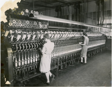
Photograph - Worsted Spinning, 1960s
One of fifty one photographs originally in a photo album found in the National Wool Museum’s office. The album was water damaged and the images were removed for conservation. The images follow the process of wool. Beginning in a sheep paddock and finishing as a folded fabric. It includes all the steps in between in this process, including shearing, transporting, selling, washing and the many different steps in the process of turning a single thread of wool into fabric.Black and white image showing two women working at a worsted spinning machine.AUSTRALIAN NATIONAL PUBLICITY / ASSOCIATION / FLINDERS STREET RAILWAY BUILDING, / MELBOURNE AUSTRALIA / W19 / W19. , Worsted Spinning.wool industry, working life, women, boonoke station, farming, sheep farming, agriculture, sheep stations, transport, wool processing, shearing, textile industry, wool -
 National Wool Museum
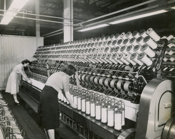
Photograph - Cone Roving, 1960s
One of fifty one photographs originally in a photo album found in the National Wool Museum’s office. The album was water damaged and the images were removed for conservation. The images follow the process of wool. Beginning in a sheep paddock and finishing as a folded fabric. It includes all the steps in between in this process, including shearing, transporting, selling, washing and the many different steps in the process of turning a single thread of wool into fabric.Black and white image showing two women working at a cone roving machine.AUSTRALIAN NATIONAL PUBLICITY / ASSOCIATION / FLINDERS STREET RAILWAY BUILDING, / MELBOURNE AUSTRALIA / W22 / W22. Cone Roving.wool industry, working life, women, boonoke station, farming, sheep farming, agriculture, sheep stations, transport, wool processing, shearing, textile industry, wool -
 National Wool Museum
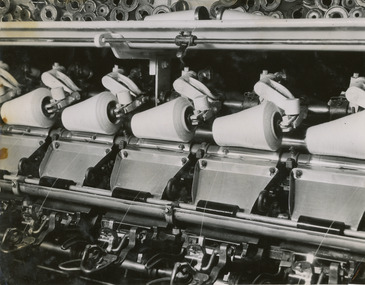
Photograph - Cone Winding, 1960s
One of fifty one photographs originally in a photo album found in the National Wool Museum’s office. The album was water damaged and the images were removed for conservation. The images follow the process of wool. Beginning in a sheep paddock and finishing as a folded fabric. It includes all the steps in between in this process, including shearing, transporting, selling, washing and the many different steps in the process of turning a single thread of wool into fabric.Black and white image showing detail of a cone winding machine.AUSTRALIAN NATIONAL PUBLICITY / ASSOCIATION / FLINDERS STREET RAILWAY BUILDING, / MELBOURNE AUSTRALIA / W20 / W20. Cone Winding.wool industry, working life, women, boonoke station, farming, sheep farming, agriculture, sheep stations, transport, wool processing, shearing, textile industry, wool -
 National Wool Museum
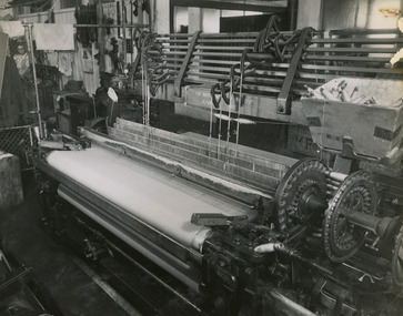
Photograph - Weaving Machine, 1960s
One of fifty one photographs originally in a photo album found in the National Wool Museum’s office. The album was water damaged and the images were removed for conservation. The images follow the process of wool. Beginning in a sheep paddock and finishing as a folded fabric. It includes all the steps in between in this process, including shearing, transporting, selling, washing and the many different steps in the process of turning a single thread of wool into fabric.Black and white image showing a weaving machine.AUSTRALIAN NATIONAL PUBLICITY / ASSOCIATION / FLINDERS STREET RAILWAY BUILDING, / MELBOURNE AUSTRALIA / W26 / W26. Weaving.wool industry, working life, women, boonoke station, farming, sheep farming, agriculture, sheep stations, transport, wool processing, shearing, textile industry, wool -
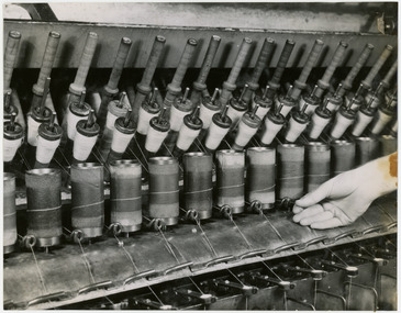 National Wool Museum
Photograph - Twisting or Doubling, 1960s
One of fifty one photographs originally in a photo album found in the National Wool Museum’s office. The album was water damaged and the images were removed for conservation. The images follow the process of wool. Beginning in a sheep paddock and finishing as a folded fabric. It includes all the steps in between in this process, including shearing, transporting, selling, washing and the many different steps in the process of turning a single thread of wool into fabric.Black and white image showing detail of machinery with spools of wool. A hand is shown on the right handling a thread of wool.AUSTRALIAN NATIONAL PUBLICITY / ASSOCIATION / FLINDERS STREET RAILWAY BUILDING, / MELBOURNE AUSTRALIA / W18 / W18. Twisting or Doubling.wool industry, working life, women, boonoke station, farming, sheep farming, agriculture, sheep stations, transport, wool processing, shearing, textile industry, wool -
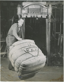
 National Wool Museum
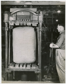
Photograph - Bale in Dumping Machine, 1960s
One of fifty one photographs originally in a photo album found in the National Wool Museum’s office. The album was water damaged and the images were removed for conservation. The images follow the process of wool. Beginning in a sheep paddock and finishing as a folded fabric. It includes all the steps in between in this process, including shearing, transporting, selling, washing and the many different steps in the process of turning a single thread of wool into fabric.Black and white image showing a wool bale in a Robinson Bro dumping machine. A man is standing to the side of the machine.AUSTRALIAN NATIONAL PUBLICITY / ASSOCIATION / FLINDERS STREET RAILWAY BUILDING, / MELBOURNE AUSTRALIA / W4 / W4. Bale in dumping machine.wool industry, working life, women, boonoke station, farming, sheep farming, agriculture, sheep stations, transport, wool processing, shearing, textile industry, wool -
 National Wool Museum
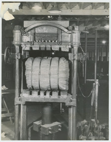
Photograph - Bale Dumped and Strapped, 1960s
One of fifty one photographs originally in a photo album found in the National Wool Museum’s office. The album was water damaged and the images were removed for conservation. The images follow the process of wool. Beginning in a sheep paddock and finishing as a folded fabric. It includes all the steps in between in this process, including shearing, transporting, selling, washing and the many different steps in the process of turning a single thread of wool into fabric.Black and white image showing a wool bale in a Robinson Bro dumping machine.AUSTRALIAN NATIONAL PUBLICITY / ASSOCIATION / FLINDERS STREET RAILWAY BUILDING, / MELBOURNE AUSTRALIA / W7 / W 7. Bale dumped and strapped.wool industry, working life, women, boonoke station, farming, sheep farming, agriculture, sheep stations, transport, wool processing, shearing, textile industry, wool