Showing 748 items matching "reynolds"
-
 Carlton Football Club
Hardcover Book, Kouta, 1/11/07
Anthony Koutoufides - Biography/Autobiography Date of birth 18 January 1973 (age 46) Original team(s) Lalor Debut Round 13, 1992, Carlton vs. Adelaide, at Princes Park Height 191 cm (6 ft 3 in) Weight 100 kg (220 lb) Years Club Games (Goals) 1992–2007 Carlton 278 (226) Career highlights Leigh Matthews Trophy (AFLPA MVP): 2000 Robert Reynolds Trophy: 2001, 2005 All Australian: 1995, 2000 Carlton Captain: 2004–2006 Carlton Leading Goalkicker: 1997 Carlton premiership team: 1995 AFL and Carlton life-member Victorian State of Origin: 1999 Australian Football Hall of Fame inductee 2014 Greek Team of the Century: Vice-Captain VFL/AFL Italian Team of the Century: Centre Half-BackBook outlining Career & Life of one of Carlton's most popular & gifted players. Kouta was a match winner whose career was curtailed by injury. Kouta's most famous game was Carlton's 1 point win over Essendon 1999 Prelim Final -
 Orbost & District Historical Society
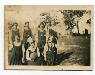
black and white photographs, 1920s
These photographs are of students of the Orbost Higher Elementary School. Information with photographs includes the names of those in the photos. 3143.1 - Alice Boucher; Bill Kerr; Mollie Hammil; Margie Trewin; ? Pen; Marion Nixon. 3143.2 - Back : Mollie Lock; Margaret Irvine; Lizzie Foard; Esme Reynolds; Marge Foard Front: Pen Gilbert; Mary Gilbert; Zenie Irvine; Hilda Bird. This was the first team to beat Bairnsdale High. 3143.3 - Marion with ball; ? Boucher; Myra Malcolm; L. Farquhar; ? Boucher; Mary Gilbert; Marion Trewin 3143.4 - Back - Alice Hammil; Marion Nixon; Bill Kerr; Annie Malcolm, E. Gall\Front - Marion Gilbert; Pen Gilbert; Elsie Pardew; Jean Trewin During 1910-11 the first approaches were made to the Department for the establishment of a HES in Orbost and this became a reality in 1912. Orbost HES supplied post-primary education in the district until a high school was built in 1948. Orbost High School / Orbost Secondary College has played a significant part in the education of senior students in the Orbost district . It is the sole senior educational institution. This item is representative of its historyFour black / white photographs of Orbost High School netball teams. 3143.1 is of seven girls in sports uniforms. Four are standing and three kneeling in front of them The girl in middle front is holding a ball. The photograph has been taken outside on a sports field with a low fence in the background. 3143.2 is of nine girls in sports uniforms. Five are standing and the front brow of four are seated on chairs. . The photograph has been taken outside. the two girls middle front are holding a ball on which is written "1920". 3143.3 is of nine girls in uniform in front of a brick wall. Four are standing, five seated on a bench. The girl middle front is holding a ball which has "Orbost H.E.S. 1926" written on it. 3143.4 is a photograph / postcard. It is of nine girls in two rows. Five at the back are standing and the front row is seated on a bench. On the ball held by girl 2nd left is written "1923". The photograph has been taken outside and there is a gazebo in the background. There is a trophy on the ground in front of them.3143.2 - "O.H.E.S. 1920" 3143.4 - Bottom right corner -"L.N."education-orbost orbost-higher-elementary-school school-sport netball -
 Bendigo Historical Society Inc.
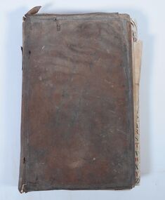
Administrative record - Account Book, 1859
The purchases and services recorded indicate that the user was an ironmonger. Origin of ledger unknown. Early business in Sandhurst in 1860s.An account ledger used to record the purchases and services made for a business. Records date from 1860. The ledger is covered with brown leather with decorative edges. There are alphabetical tabs at the front of the book with lists of names. Individual customers are allocated a double page entry. Pages are ruled and numbered. The book is in very poor condition having obvious signs of water and insect damage. The writing in the first quarter of the book is barely legible, remaining pages can be read. Some names - Durant, Watson, Mollison, Harris, Neale, Cahley, Bannerman, Larritt, Cranshaw, Gripe, McLachlan, Burrell, O'Loughlin, Cameron Rogers, McLevey, Nicholas Eliad?, Crago, Hopsell, Grant, Bird, Cahill, Harker, Parker S McKinlay, Fletcher, Birch, Cruikshank, Municipal Council, Heffernan and Crawley, Buckley Bros, John Harney, Bywater and Brother, Goulding, Casey, Reynolds, English, McKenzie, Knight, David Mackay."LEDGER" on the spine. Label inside "Sands and Kenny. Account Book Manufacturers. Stationers and Printers Melbourne"bendigo businesses, ironmonger -
 Eltham District Historical Society Inc
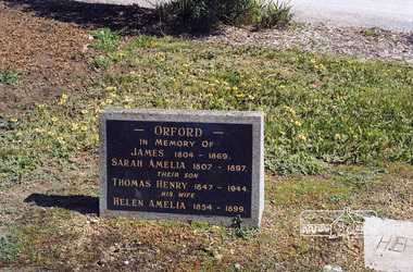
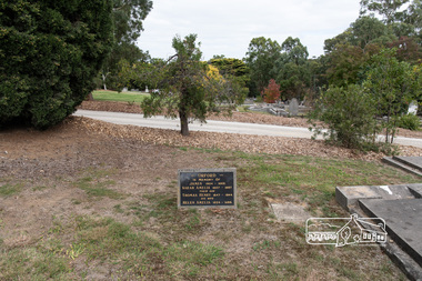
Negative - Photograph, Harry Gilham, Orford family graves, Eltham Cemetery, Victoria, Sep 2009
One of Eltham's earliest settlers was James Orford. Born 1804 in Bedfordshire, the son of George, a carpenter and Lydia Barret, he and wife Sarah Amelia nee Moull (1807) arrived as Assisted Immigrants aboard the ship, ‘Orestes’, November 28, 1839 accompanied by their children, George (14), Mary Ann (11), and James (2). Originally settling in New South Wales, daughter Sarah Amelia was born at Braidwood in 1843 and son, Thomas Henry at Pambula in 1847. James was a carpenter who is known to have built the original gates to Eltham Cemetery. He died in 1869. Around 1890, his son Thomas Henry Orford was living in Pitt Street. Following the death of his wife Helen in 1899, Thomas was appointed by Joseph Panton to look after ‘Panton Park’, a 429-acre bushland property at the fork of Reynolds and Laughing Waters Roads, extending down to the Yarra River. His work entailed ringbarking the manna gums on the property to clear the land for pasture. Thomas lived in a slab hut with his son Ernie, who helped with the work. When Gordon Lyon purchased Panton Park in 1908, Thomas then worked for Lyon at both Panton Park and at ‘Banyule’, Lyon's stud farm at Heidelberg. In 1915 Lyon gave Thomas six acres of land in Reynolds Road with a two-roomed cottage. Thomas died in 1944 and is buried in Eltham Cemetery with his wife and his parents. Another of James Orford's sons was James Matthias Orford. He tried to grow food on land at the end of Laughing Waters Road, but without success. Reputedly the Wurundjeri taught him to swim. He was once imprisoned; when his friend Constable Lawlor invited him to inspect the new bluestone lock-up, Lawlor locked him in and wouldn't release him until he was promised two gallons of beer! ORFORD In Memory Of James 1804 -1869 Sarah Amelia 1807 - 1897 Their son Thomas Henry 1847 - 1944 His wife Helen Amelia 1854 - 1899Roll of 35mm colour negative film, 6 stripsKodak GC 400-9eltham cemetery, gravestones, helen amelia orford, james orford, sarah amelia orford, thomas henry orford, cemetery gates -
 Eltham District Historical Society Inc
Photograph, Peter Pidgeon, Orford family graves, Eltham Cemetery, Victoria, 5 April 2021
One of Eltham's earliest settlers was James Orford. Born 1804 in Bedfordshire, the son of George, a carpenter and Lydia Barret, he and wife Sarah Amelia nee Moull (1807) arrived as Assisted Immigrants aboard the ship, ‘Orestes’, November 28, 1839 accompanied by their children, George (14), Mary Ann (11), and James (2). Originally settling in New South Wales, daughter Sarah Amelia was born at Braidwood in 1843 and son, Thomas Henry at Pambula in 1847. James was a carpenter who is known to have built the original gates to Eltham Cemetery. He died in 1869. Around 1890, his son Thomas Henry Orford was living in Pitt Street. Following the death of his wife Helen in 1899, Thomas was appointed by Joseph Panton to look after ‘Panton Park’, a 429-acre bushland property at the fork of Reynolds and Laughing Waters Roads, extending down to the Yarra River. His work entailed ringbarking the manna gums on the property to clear the land for pasture. Thomas lived in a slab hut with his son Ernie, who helped with the work. When Gordon Lyon purchased Panton Park in 1908, Thomas then worked for Lyon at both Panton Park and at ‘Banyule’, Lyon's stud farm at Heidelberg. In 1915 Lyon gave Thomas six acres of land in Reynolds Road with a two-roomed cottage. Thomas died in 1944 and is buried in Eltham Cemetery with his wife and his parents. Another of James Orford's sons was James Matthias Orford. He tried to grow food on land at the end of Laughing Waters Road, but without success. Reputedly the Wurundjeri taught him to swim. He was once imprisoned; when his friend Constable Lawlor invited him to inspect the new bluestone lock-up, Lawlor locked him in and wouldn't release him until he was promised two gallons of beer! ORFORD In Memory Of James 1804 -1869 Sarah Amelia 1807 - 1897 Their son Thomas Henry 1847 - 1944 His wife Helen Amelia 1854 - 1899Born Digitaleltham cemetery, gravestones, helen amelia orford, james orford, sarah amelia orford, thomas henry orford -
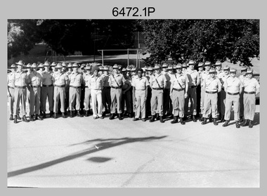
 Bendigo Military Museum
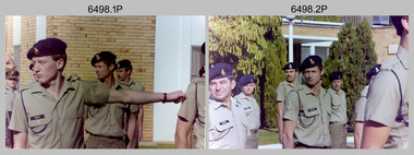
Photograph - 4th Field Survey Squadron OC’s Parades and Defence Force Service Medal Presentations, Keswick Barracks, Adelaide SA, 1986
This is a set of 27 photographs of a 4th Field Survey Squadron OC’s parade at Keswick Barracks, Adelaide SA in 1986. The OC - MAJ Don Taylor presented the Defence Force Service Medal to personnel in recognition of 15 years of efficient remunerated service, or the Clasp for 5 years of additional service. Photos .22P to .27P were taken on a separate OC’s Parade. OC MAJ Don Taylor is seen in photo .27P congratulating WO2 Russell ‘Rusty Williams, probably on his promotion to WO1. This is a set of 27 photographs of a 4th Field Survey Squadron OC’s parade and the presentation of the Defence Force Service Medal, at Keswick Barracks, Adelaide SA in 1986. The colour photographs are on 35mm negative film and are part of the Army Survey Regiment’s Collection. The photographs were scanned at 96 dpi. .1) - Photo, colour, 1986. L to R: WO2 Gary Warnest in background, SPR Steve Ellis, CPL John Ratcliffe, SPR John Keely. .2) - Photo, colour, 1986. L to R: CPL Jeff Prince, SPR Bruce Graham, SGT Stuart Symonds, CPL John Ratcliffe, SGT Peter Imeson. .3) - Photo, colour, 1986. 4 Fd Svy Sqn at ease. Centre rank L to R: SPR Steve Wainwright, CPL Jeff Prince, CPL Peter Hardy. Front rank L to R: SPR Todd Hayley, SPR Steve Ellis, CPL Dave Irving, SPR Richard Cocker, SPR Damien Killeen, remainder unidentified. .4) to .6) - Photo, colour, 1986. Parade handover L to R: SSM WO1 Bill Griggs, 2IC CAPT Steve Cooper. .7) - Photo, colour, 1986. Parade handover L to R: 2IC CAPT Steve Cooper, OC MAJ Don Taylor. .8) - Photo, colour, 1986. Parade handover L to R: OC MAJ Don Taylor, 2IC CAPT Steve Cooper. .9) - Photo, colour, 1986. Inspection L to R: CPL Jeff Prince, CPL John Ratcliffe, CPL Peter Hardy, OC MAJ Don Taylor, 2IC CAPT Steve Cooper, SSM WO1 Bill Griggs. .10) - Photo, colour, 1986. Inspection L to R: WO2 Gary Warnest, WO2 Bob Rogister, WO2 Russell ‘Rusty' Williams, OC MAJ Don Taylor, SSM WO1 Bill Griggs, SGT Wally Chilcott. .11) - Photo, colour, 1986. Inspection L to R: WO2 P. Symmans, WO2 Gary Warnest, 2IC CAPT Steve Cooper, OC MAJ Don Taylor, SGT Wally Chilcott. .12) & .13 - Presentations L to R: SPR Simon Reynolds, OC MAJ Don Taylor. .14) & .15) - Photo, colour, 1986. Presentations: SSM WO1 Bill Griggs. .16) & .17) - Photo, colour, 1986. Presentations L to R: WO2 Russell ‘Rusty' Williams, OC MAJ Don Taylor, SPR Simon Reynolds. .18) - Photo, colour, 1986. Presentations: WO2 Russell ‘Rusty' Williams. .19) - Photo, colour, 1986. Presentations L to R: unidentified (x2), CPL Terry ‘TJ’ Wicker. .20) - Photo, colour, 1986. Presentations L to R: CPL Terry ‘TJ’ Wicker, OC MAJ Don Taylor, SPR Simon Reynolds, 2IC CAPT Steve Cooper. .21) - Photo, colour, 1986. Presentations L to R: CPL Terry ‘TJ’ Wicker, OC MAJ Don Taylor. 22) & .23) - Photo, colour, 1986. Parade right dress. Centre rank L to R: SPR Steve Wainwright, SPR Peter Tuddenham, CPL Jeff Prince, remainder unidentified. Front rank L to R: SPR Todd Hayley, CPL Chris ‘Charlie’ Brown, SPR Richard Cocker, unidentified, SPR Steve Nokes, CPL Dave Irving, SPR Steve Ellis remainder unidentified. .24) - Photo, colour, 1986. Presentations L to R: SPR Simon Reynolds, 2IC CAPT Steve Cooper, OC MAJ Don Taylor, CPL Dave Longbottom. .25) - Photo, colour, 1986. Presentations: CPL John Ratcliffe. .26) - Photo, colour, 1986. Presentations L to R: CPL John Ratcliffe, WO2 Russell ‘Rusty' Williams. .27) - Photo, colour, 1986. Presentations L to R: SPR Steve Ellis, unidentified, WO2 Russell ‘Rusty' Williams, SSM WO1 Bill Griggs, OC MAJ Don Taylor..1P to .27P – There are no personnel identified. ‘1986 Presentations’ annotated on negatives sleeve.royal australian survey corps, rasvy, 4 fd svy sqn -
 Ballarat Clarendon College
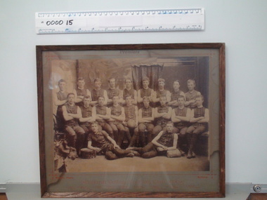
Framed photograph, Willets, Ballarat, Ballarat College Football 1890, 1890 (exact)
This photograph provides a fascinating insight into clothing and deportment in school sport in the late nineteenth century. A significant social record of clothing and deportment in school sport during the late nineteenth century. Sepia toned photograph pasted grey card mount and framed behind glass. Thin wooden frame. Photograph depicts the Ballarat College premiership football club in 1890. Players are in uniform - sleeveless, collarless shirts, knickerbockers, stockings and laced boots or shoes. There are 20 boys. The photograph is titled. 'Premiers', 'Ballarat College Football Club, 1890' and the students names are p[rinted on the mount. Printed on mount above photograph: 'Premiers' Printed below phoograph: 'Willets, Photo. Ballarat/Ballarat College Football Club, 1890/ J. Cohen, A. Greenfield, J. Cameron, A. Bregazzi, H. O'Farrell, C. Robinson, W. McCook, A. Laidlaw, W. Mockett/ F. Kersley, W. Whykes, A. McCook, M. Lynch, B. Martin, J. Rentoule, H. Bailey, H. Levein, D. Williamson/ P. Smith, E. Wanliss' Stamped on rear of framing board: 'J. A. Reynolds/Decorator and picture framer/28 Sturt St. Ballarat' ballarat college, football, 1890, uniform sports, premiership, ballarat college football club, j cohen, a greenfield, j cameron, a bregazzi, h o farrell, c robinson, w mccook, a laidlaw, w mockett, f kersley, w whykes, a mccook, m lynch, b martin, j rentoule, h bailey, h levein, d williamson, p smith, e wanliss -
 Eltham District Historical Society Inc
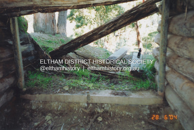
Photograph, Fay Bridge, Former Morrison property, Killeavey, Laughing Waters Road, Eltham, 28 June 2004
Beatrice Wanliss Irvine was the daughter of former Victorian Premier Sir William Irvine. From age 13 she lived at “Killeavey” off Laughing Waters Road (later accessed from Reynolds Road). In 1923 she married James Morrison and the couple received Killeavey as a wedding gift. The property supported fruit and vegetable growing as well as an impressive botanical garden. But James died in 1936 after a period of ill health, leaving Beatrice to support their six children. The Killeavey house was built atop a cliff, 40 metres above the Yarra River. The garden was designed in 1910 by William Guilfoyle who was the second director of the Royal Botanical Gardens. The house was totally destroyed in the Black Friday bushfires in 1939, but was rebuilt. Beatrice continued to live at Killeavey and became well regarded as a botanist and naturalist. She died in 1989 and is buried in Eltham Cemetery with her husband and one of their sons. The (rebuilt) house was demolished by Parks Victoria. It contains significant garden remnants. The surrounding bushland is valued for its significant plant communities.fay bridge collection, 2004-06-28, beatrice wanliss morrison (nee irvine), eltham, james morrison, killeavey, laughing waters road, william irvine -
 Eltham District Historical Society Inc
Photograph, Fay Bridge, Former Morrison property, Killeavey, Laughing Waters Road, Eltham, 30 August 2019
Beatrice Wanliss Irvine was the daughter of former Victorian Premier Sir William Irvine. From age 13 she lived at “Killeavey” off Laughing Waters Road (later accessed from Reynolds Road). In 1923 she married James Morrison and the couple received Killeavey as a wedding gift. The property supported fruit and vegetable growing as well as an impressive botanical garden. But James died in 1936 after a period of ill health, leaving Beatrice to support their six children. The Killeavey house was built atop a cliff, 40 metres above the Yarra River. The garden was designed in 1910 by William Guilfoyle who was the second director of the Royal Botanical Gardens. The house was totally destroyed in the Black Friday bushfires in 1939, but was rebuilt. Beatrice continued to live at Killeavey and became well regarded as a botanist and naturalist. She died in 1989 and is buried in Eltham Cemetery with her husband and one of their sons. The (rebuilt) house was demolished by Parks Victoria. It contains significant garden remnants. The surrounding bushland is valued for its significant plant communities.fay bridge collection, beatrice wanliss morrison (nee irvine), eltham, james morrison, killeavey, laughing waters road, william irvine, 2019-08-30 -
 Eltham District Historical Society Inc
Photograph, Fay Bridge, Former Morrison property, Killeavey, Laughing Waters Road, Eltham, 27 October 2019
Beatrice Wanliss Irvine was the daughter of former Victorian Premier Sir William Irvine. From age 13 she lived at “Killeavey” off Laughing Waters Road (later accessed from Reynolds Road). In 1923 she married James Morrison and the couple received Killeavey as a wedding gift. The property supported fruit and vegetable growing as well as an impressive botanical garden. But James died in 1936 after a period of ill health, leaving Beatrice to support their six children. The Killeavey house was built atop a cliff, 40 metres above the Yarra River. The garden was designed in 1910 by William Guilfoyle who was the second director of the Royal Botanical Gardens. The house was totally destroyed in the Black Friday bushfires in 1939, but was rebuilt. Beatrice continued to live at Killeavey and became well regarded as a botanist and naturalist. She died in 1989 and is buried in Eltham Cemetery with her husband and one of their sons. The (rebuilt) house was demolished by Parks Victoria. It contains significant garden remnants. The surrounding bushland is valued for its significant plant communities.fay bridge collection, beatrice wanliss morrison (nee irvine), eltham, james morrison, killeavey, laughing waters road, william irvine, 2019-10-27 -
 Eltham District Historical Society Inc
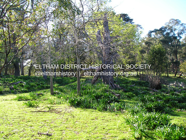
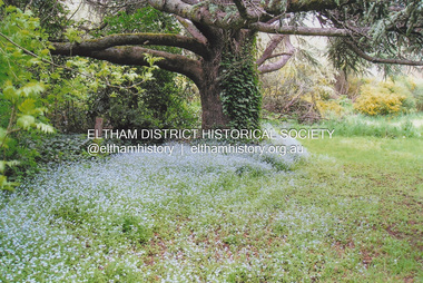
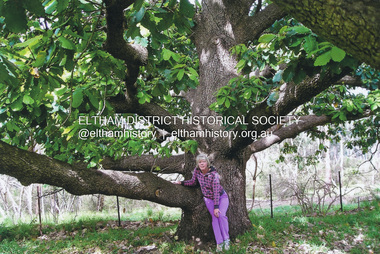
Photograph, Fay Bridge, New Zealand Oak at former Morrison property, Killeavey, Laughing Waters Road, Eltham, n.d
Beatrice Wanliss Irvine was the daughter of former Victorian Premier Sir William Irvine. From age 13 she lived at “Killeavey” off Laughing Waters Road (later accessed from Reynolds Road). In 1923 she married James Morrison and the couple received Killeavey as a wedding gift. The property supported fruit and vegetable growing as well as an impressive botanical garden. But James died in 1936 after a period of ill health, leaving Beatrice to support their six children. The Killeavey house was built atop a cliff, 40 metres above the Yarra River. The garden was designed in 1910 by William Guilfoyle who was the second director of the Royal Botanical Gardens. The house was totally destroyed in the Black Friday bushfires in 1939, but was rebuilt. Beatrice continued to live at Killeavey and became well regarded as a botanist and naturalist. She died in 1989 and is buried in Eltham Cemetery with her husband and one of their sons. The (rebuilt) house was demolished by Parks Victoria. It contains significant garden remnants. The surrounding bushland is valued for its significant plant communities.fay bridge collection, beatrice wanliss morrison (nee irvine), eltham, james morrison, killeavey, laughing waters road, william irvine, new zealand oak -
 Eltham District Historical Society Inc
Photograph, Fay Bridge, Fay Bridge with New Zealand Oak at former Morrison property, Killeavey, Laughing Waters Road, Eltham, n.d
Beatrice Wanliss Irvine was the daughter of former Victorian Premier Sir William Irvine. From age 13 she lived at “Killeavey” off Laughing Waters Road (later accessed from Reynolds Road). In 1923 she married James Morrison and the couple received Killeavey as a wedding gift. The property supported fruit and vegetable growing as well as an impressive botanical garden. But James died in 1936 after a period of ill health, leaving Beatrice to support their six children. The Killeavey house was built atop a cliff, 40 metres above the Yarra River. The garden was designed in 1910 by William Guilfoyle who was the second director of the Royal Botanical Gardens. The house was totally destroyed in the Black Friday bushfires in 1939, but was rebuilt. Beatrice continued to live at Killeavey and became well regarded as a botanist and naturalist. She died in 1989 and is buried in Eltham Cemetery with her husband and one of their sons. The (rebuilt) house was demolished by Parks Victoria. It contains significant garden remnants. The surrounding bushland is valued for its significant plant communities.fay bridge collection, beatrice wanliss morrison (nee irvine), eltham, james morrison, killeavey, laughing waters road, william irvine, new zealand oak, fay bridge -
 Bendigo Military Museum
Photograph - Lithographic Squadron with DCP Students, Army Survey Regiment, Fortuna Villa, Bendigo, 1985
This is a set of six photographs of Lithographic Squadron personnel with Defence Cooperation Program (DCP) students at the Army Survey Regiment, Fortuna Villa, Bendigo Victoria, 1985. These informal and formal group photos were taken on the day of a CO’s Parade. Litho Squadron provided printing and photographic reproduction to the two DCP students. RA Svy also provided technical training to DCP students in map production skills such as, cartography and photogrammetry at the Army Survey Regiment and the School of Military Survey, Bonegilla. The Australian Defence Force over several years sponsored international students from counties such as Indonesia, Malaysia, Papua New Guinea, Philippines, Solomon Islands and Vanuatu. It is not known which South Pacific country these DCP students came from.This is a set of six photographs of Lithographic Squadron personnel with Defence Cooperation Program (DCP) students at the Army Survey Regiment, Fortuna Villa, Bendigo Victoria, 1985. The photographs are on 35mm negative film and were scanned at 96 dpi. They are part of the Army Survey Regiment’s Collection. .1) Photo, black & white, 1985. L to R: Warren ‘Waldo’ Shirley, Per Andersen, Trevor Osborne, Roy Hicks, Lance Strudwick, Steve Burke, Dale Hudson, Paul Baker, Ralph Chant, Peter Breukel, John ‘Flash’ Anderson, Chad Hardwick, Peter Imeson, DCP student John or Henry, unidentified, Greg Rowe, John South, unidentified, Mick ‘Buddha’ Ellis, John ‘Junior’ Whaling, Terry King, Daryl South, DCP student John or Henry, Bronwyn Jones, John Bateman, Kerron South, unidentified officer, Peter Dillon, Kim Reynolds, Rob Jones, unidentified, Jeff Lynch, Garry Hudson, Mark ‘Dogs’ Doherty, Jim Ash, Gavin Neilson, Jeff Willey, unidentified, Graham Johnston, Steve Egan, Peter Barrett, George Austen, Dave Miles. .2) - Photo, black & white, 1985. L to R: Warren ‘Waldo’ Shirley, Per Andersen, Trevor Osborne, Roy Hicks, Lance Strudwick, Steve Burke, Dale Hudson, Paul Baker, Ralph Chant, Peter Breukel, John ‘Flash’ Anderson, Chad Hardwick, Peter Imeson, DCP student John or Henry, unidentified, Greg Rowe, John South, unidentified, Mick ‘Buddha’ Ellis, John ‘Junior’ Whaling, Terry King, Daryl South, DCP student John or Henry, John Bateman, Kerron South, unidentified officer, Peter Dillon, Kim Reynolds, Rob Jones, unidentified, Jeff Lynch, Garry Hudson, Mark ‘Dogs’ Doherty, Jim Ash, Gavin Neilson, Jeff Willey, unidentified, Graham Johnston, Steve Egan, Peter Barrett, Dave Miles, George Austen. .3) - Photo, black & white, 1985. Photo Troop L to R: Steve Burke, Garry Hudson, Warren ‘Waldo’ Shirley, Ralph Chant, Gavin Neilson, DCP student John or Henry, Paul Baker, Trevor Osborne, Peter Imeson, Mick ‘Buddha’ Ellis, unidentified, John ‘Junior’ Whaling, DCP student John or Henry, Chad Hardwick, Terry King, Dave Miles, Graham Johnston, Kerron South, Bronwyn Jones, Rob Jones, unidentified. .4) - Photo, black & white, 1985. L to R: WO1 Jeff Lynch, DCP student John or Henry, CAPT John South, unidentified officer, DCP student John or Henry, WO2 Dave Miles. .5) & .6) - Photo, black & white, 1985. Print Troop L to R: Per Andersen, Daryl South, Lance Strudwick, Peter Dillon, DCP student John or Henry, Jeff Willey, John Bateman, Roy Hicks, Paul Davis, Dale Hudson, Kim Reynolds, Greg Rowe, Jim Ash, DCP student John or Henry, Mark ‘Dogs’ Doherty, Peter Breukel, Peter Barrett, unidentified, unidentified officer, Steve Egan, George Austen.No personnel are identified. Date and DCP students noted on film negative sleeve.royal australian survey corps, rasvy, army survey regiment, army svy regt, fortuna, asr, litho sqn, litho -
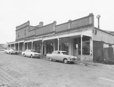 Ringwood and District Historical Society
Photographs, Block Buildings, Adelaide St Ringwood before demolition for Eastland 1965
Set of 11 Black and White photos of the Block Buildings corner Adelaide St and Maroondah Hwy, Ringwood. Taken for Court - site inspection by Mr Justice Barber 6.8.1965. Part of the Eastland Compensation Litigation (See Reference below). (Renamed and recatalogued into this one item 2018). 381A: Adelaide St Shops 381B: Rear of Coffee Palace, Maroondah Hwy 381C: Adelaide Street Shops 381D: Side and Rear of Renong Chambers, cnr Civic Place and Adelaide ST 381E: Renong Chambers Adelaide St. )Reynolds Fish and Chip shop on ground floor) 381F: Back of the Coffee Palace 381G: Rear of Adelaide St Shops, off Civic Place. cf SS038k (Record #2832). Taken from Civic Place 381H: Maroondah Hwy, looking towards Adelaide St 381I: Cnr Maroondah Hwy and Adelaide St 381J: Old House, taken from laneway now Civic Place 381K: Coffee Palace, Maroondah HwyStamped on back: Peter Payens of Ringwood Studios. 86 Whitehorse Road, Ringwood -
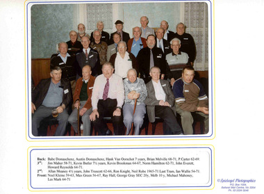 Ballarat Tramway Museum
Memorabilia - Presentation Photograph Folder, Speilvogel Photographic, SEC Ballarat Tramway Employees photographed at the Queens Head Hotel, 2001
Yields information about the people who attended the 30anniversary reunion of the closure of the Ballarat Tramway system. Has a strong association with these people.Colour photograph of the former SEC Ballarat Tramway Employees photographed at the Queens Head Hotel on the occasion of the "Ballarat Tramways Past Employees' Reunion to mark 30 Years Closure of the Ballarat Tramways" on September 15, 2001. Photograph mounted within a white cardboard folder with the names of the attendees and period of service listed underneath. On the front cover has printed image of Ballarat 40 at Sebastopol with the name and date of the event printed on it. Folder prepared by Speilvogel Photographic, P.O. Box 1004, Ballarat Mail Centre, Vic. 3354. Featured in the photograph are: Babe Domaschenz, Austin Domaschenz, Han Van Oorschot, Brian Melville, P Carter, Jim Maher, Kevin Butler, Kevin Brookman, Norm Hamilton, John Everett, Howard Reynolds, Allan Meaney, John Truscott, Ron Knight, Neil Robe, Ian Wallis, Noel Kleine, Max Green, Ray Hall, George Gray, Michael Mahoney, Les Mark. 2nd copy of 1968 - ex Kevin Brookman, added 1/6/2009.trams, tramways, employees, reunions, tram crews -
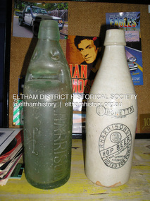 Eltham District Historical Society Inc
Photograph, Fay Bridge, Old bottles found at former Morrison property, Killeavey, Laughing Waters Road, Eltham, 2019
Lemonade, Non-alcoholic Hop Beer and milk bottlkes recovered from Killeavey give an insight into the types of drinks consumed by the Morrison family. Beatrice Wanliss Irvine was the daughter of former Victorian Premier Sir William Irvine. From age 13 she lived at “Killeavey” off Laughing Waters Road (later accessed from Reynolds Road). In 1923 she married James Morrison and the couple received Killeavey as a wedding gift. The property supported fruit and vegetable growing as well as an impressive botanical garden. But James died in 1936 after a period of ill health, leaving Beatrice to support their six children. The Killeavey house was built atop a cliff, 40 metres above the Yarra River. The garden was designed in 1910 by William Guilfoyle who was the second director of the Royal Botanical Gardens. The house was totally destroyed in the Black Friday bushfires in 1939, but was rebuilt. Beatrice continued to live at Killeavey and became well regarded as a botanist and naturalist. She died in 1989 and is buried in Eltham Cemetery with her husband and one of their sons. The (rebuilt) house was demolished by Parks Victoria. It contains significant garden remnants. The surrounding bushland is valued for its significant plant communities.fay bridge collection, beatrice wanliss morrison (nee irvine), eltham, james morrison, killeavey, laughing waters road, william irvine, bennett lemonade, bottles, milk bottle, o'neill bros north fitzroy, r. harrison, r. harrisons hop beer -
 Eltham District Historical Society Inc
Photograph - Digital Photograph, Alan King, Golden King Mine poppet-head, Yarrambat Primary School, 1 February 2008
The Golden King Mine poppet-head stands at the school’s Yan Yean Road exit gate. Published: Nillumbik Now and Then / Marguerite Marshall 2008; photographs Alan King with Marguerite Marshall.; p23 Early Yarambat - Tanck's Corner Its early settlers, who in the 1840s were amongst the first non-Aboriginal people in the area, found life tough as they grazed their sheep and cattle. Yarrambat was then known as Tanck’s Corner or Reynolds Corner, after wood carter, Frederick Tanck, who owned land north of Ironbark Road, at the corner of Yan Yean Road, and Thomas Reynolds, owner of the opposite property. After Reynolds sold his land, the corner became known as Tanck’s Corner. In 1929 the district’s name was changed to Yarrambat, believed to mean ‘high hill’ in the Wurundjeri language. Tanck’s Corner was in the centre of gold-bearing country and the district is honeycombed with old tunnels and shafts. However although gold played a dominant role for decades, there was insufficient to develop a substantial township. Meat and agricultural produce made a greater impact. Until the mid-20th century the only substantial building was the primary school. The first gold rush occurred around 1860, the second after 1900; then during the Depression, the Government paid men to pan for gold. The first rush attracted hundreds of Chinese people to Smugglers Gully, who constructed round diggings to keep away spirits. Alluvial miners lived along the Plenty River in tents or humpies - some fenced with gardens - and some miners distilled their own ‘plonk’. It was a wild time and bushrangers - and later gangster Squizzy Taylor - were said to hide4 in the old Pioneer Tunnel in Dunne’s Gully between Heard Avenue and Pioneer Road. Mines opposite Tanck’s Corner included Beer’s Line, Golden Crown and Golden Stairs. Some of the big mines had batteries and stampers to process quartz. At first there was plenty of alluvial gold, as much as two ounces to the ton. At times gold was exposed after heavy rains so fossickers panned for gold around orchard irrigation trenches. Gold was mined until 1984 when Yarrambat’s last operating goldmine, the Golden King Mine, in North Oatlands Road, closed. The Clayton family operated it full-time, making a comfortable living and in the 1960s it was the only private family gold mine in Victoria.5 Gold was such an important part of Yarrambat’s history that a gold poppet-head is the Yarrambat Primary School’s logo. The Golden King Mine poppet-head stands at the school’s Yan Yean Road exit gate. However this school was built in 1988. The original school No 2054, at the corner of Ironbark and Yan Yean Roads, was opened in 1878 and modified to its present form in the 1920s. In 2000 it was relocated to the Heritage Museum at Yarrambat Park.7 The school, whose first head teacher was Charles Planner, consisted of one room with a three-roomed residence. The school was also the community centre. On Saturday nights it was crammed for dances or euchre parties, community singing or other social events. On Sundays, services for different denominations took turns each week. However the school had its teething problems. Parents accused Charles Planner of neglecting his duties and the school closed several times. When it closed in 1892, only church services continued. Social activities moved elsewhere, such as the tennis club to the Stuchbery tennis court opposite. A sports day and woodchop on Boxing Day around 1900 was held at the Evelyn Hill Hotel, also called Evelyn Arms and Tunnel Hill Hotel, on the Greensborough–Diamond Creek Road. An annual agricultural show in Diamond Creek paraded through the town, and New Year’s Day picnics at the Yan Yean Reservoir included highland dancing and competitions. Also popular were the Indian hawkers who visited every three months, selling trinkets, clothing and other items. One called Jimmy ‘Allem dem Bedi’, gave presents and told stories, played draughts and sold delicious curries he cooked over his camp fire at night.This collection of almost 130 photos about places and people within the Shire of Nillumbik, an urban and rural municipality in Melbourne's north, contributes to an understanding of the history of the Shire. Published in 2008 immediately prior to the Black Saturday bushfires of February 7, 2009, it documents sites that were impacted, and in some cases destroyed by the fires. It includes photographs taken especially for the publication, creating a unique time capsule representing the Shire in the early 21st century. It remains the most recent comprehenesive publication devoted to the Shire's history connecting local residents to the past. nillumbik now and then (marshall-king) collection, golden king mine, tanck's corner, yarrambat primary school -
 Bendigo Military Museum
Photograph - Maps despatched by Printer Technicians at the Army Survey Regiment, c1970s to c1990s
These nine photographs of Printer Technicians working on the despatch of bulk printed map stock to customers, were probably taken circa 1970s to 1990s in Lithographic Squadron at the Army Survey Regiment, Fortuna, Bendigo. Except for photo .3P, personnel are not annotated on the photos. Despatch was the final task performed by a team of Printer Technicians. It involved the wrapping of trimmed bulk maps into manageable parcels and sending them by freight to customers or to the Army Map Depot at Bandiana, VIC. The task’s Due date and sensitivity were essential considerations in the planning of production affecting the lead time and method of delivery. Freighting by commercial means was the normal method for routine tasks. The method of despatch for urgent time-critical tasks sometimes meant having to use military freight or safe-handed by Army Survey Regiment personnel. The mishap captured in photos .6P and .7P was rare, but costly if it was a time critical task. The Print Room’s Map Handling Station in photos .8P and .9P provided ergonomic benefits to the Printer Technician and improved despatch productivity.This is a set of photographs of Printer Technicians involved in the despatch of bulk printed map stock c1970s to c1990s. The photographs were printed on photographic paper and are part of the Army Survey Regiment’s Collection. The photographs were scanned at 300 dpi. .1) - Photo, black & white, c1970s, L to R: unidentified, unidentified, Lithographic Squadron .2) - Photo, black & white, c1980s, Steve Egan, Lithographic Squadron .3) - Photo, black & white, c1980s, L to R: unidentified, Kim Reynolds, Lithographic Squadron .4) - Photo, colour, c1980s, L to R: Jeff Willey, Gary Kerr, Lithographic Squadron .5) - Photo, black & white, c1980s, L to R: Jim Ash, Mark ‘Dogs’ Doherty, Stuart Ridge, Lithographic Squadron .6) - Photo, colour, c1980s, printed maps toppled, Lithographic Squadron .7) - Photo, colour, c1980s, printed maps toppled, Lithographic Squadron .8) - Photo, black & white, c1990s, L to R: unidentified, unidentified, Lithographic Squadron .9) - Photo, black & white, c1990s, unidentified, Lithographic Squadron .3P, personnel annotation on back. .1P, .2P, .4P, .5P, .8P and .9P – no personnel annotated .6P and .7P – ‘Good one Daryl’ annotated on back.royal australian survey corps, rasvy, army survey regiment, army svy regt, fortuna, asr, litho, printing -
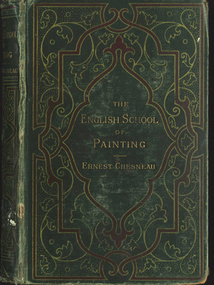 Federation University Historical Collection
Book, The English School of Painting, 1885, 1885
Green hardcovered booknon-fictionballarat technical art school library, english school of painting, pre-raphaelites, caricature, watercolour, reynolds, gainsborough, john linnell, john leech, f. holl, a. hopkins, john gilbert, f. walker, g.f. watts, r.w. macbeth, edwin edwards, j.e. millais, j.m.w. turner, john constable, r.p. bonington, old masters, w. hogarth, c.r. leslie -
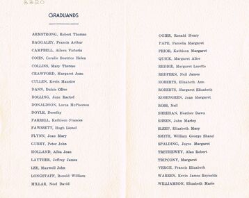 Bendigo Historical Society Inc.
Document - LA TROBE UNIVERSITY BENDIGO COLLECTION: BENDIGO TEACHERS' COLLEGE GRADUATION CEREMONY
A small cream copy of the 1952 Bendigo Teachers' College Graduation Ceremony. On the inside cover is a list of the Graduands - Robert Thomas Armstrong, Francis Arthur Baggage, Aileen Victoria Campbell, Coralie Beatrice Helen Cohn, Mary Therese Collins, Margaret Joan Crawford, Kevin Maurice Cullen, Dulcie Olive Dann, June Rachel Dolling, Lorna McPherson Donaldson, Dorothy Doyle, Kathleen Frances Farrell, Hugh Lionel Fawssett, Joan Mary Flynn, Peter John Gurry, Ailsa Jean Holland, Jeffrey James Layther, Maxwell John Lee, Ronald William Longstaff, Noel David Millar, Ronald Henry Ogier, Pamelia Margaret Pape, Margaret Alice Quick, Neil James Redfern, Elizabeth Ann Roberts, Margaret Elizabeth Roberts, Joan Margaret Rosengren, Neil Ross, Heather Dawn Sheehan, John Marley Sheen, Elizabeth Mary Sleep, William George Shand Smith, Joyce Margaret Spalding, Alan Robert Trethewey, Margaret Tripcony, Francis Elizabeth Verge, Kevin James Reynolds Warren and Elizabeth Marie Williamson. Within the program is a loose sheet of paper with a copy of the graduation procedure.bendigo, education, bendigo teachers' college graduatio, latrobe university bendigo collection, collection, bendigo teachers' college, bendigo, education, teaching, teachers, student, bendigo teachers' college graduation, graduation, bendigo teachers' college students, bendigo teachers' college staff, tertiary education, book, history -
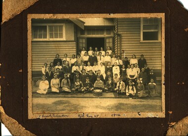 Orbost & District Historical Society
black and white photograph, 1915
This is a photograoh of students at the Higher Elementary School at Orbost. Mary Gilbert has identified those in the photograph. From L-R Back Row - ? Irvine; Madge Macalaster; Rhoda Perry; Daisy Scouller; Dorrie Napier; Lila Perry; Don Cameron_____________________- Rita Murray; Raay Fisher; Grace Morris; Reston Nish; Bill Irvine; Stella Rodwell; Headmaster Mr W. Guy; ?; Annie Stirling; Harold Napier; R Lay; Dora Smith; Doris Shortell; Percy Hambrock Nellie MacPherson; Irene Parker; Gertie Griebenow; Vera Saunders; Mr Jack Blaikie; Bernice Feltis; Dillkys Broome; Vera Spink; Jean Irvine; Lexie Nixon; Eda Ross; Maggie Whillance; Violet Scouller; Jean Stirling; Miss Zoe Hazlett; Lily Daly; Jack Parker; Eric Herbert; ?; Tom Henderson; Frank Richardson; Vance Moysey; Vernon Nevins; Frank Rodwell; Bill Fisher; ? Murray Kerr Molly Dreverman; Emmy Gibbs; Hilda Kerr; Charlie Richards; Mick; Spink; Tom Swan; Ronnie Gluth; Annie Gibbs; Madge Grose; Mary Reynolds During 1910-11 the first approaches were made to the Department for the establishment of a HES in Orbost and this became a reality in 1912. Orbost HES supplied post-primary education in the district until a high school was built in 1948.Orbost High School / Orbost Secondary College has played a significant part in the education of senior students in the Orbost district . It is the sole senior educational institution. This photograph is representative of its history.A black / white photograph of children in front of a timber building with an open door. One female and two adult male teachers are with the children. At the front centre is a drum. Behind the drum is a boy holding a board with H.E.S. Orbost hand-written in what appears to be white chalk on a blackboard. There are three smaller boys holding brass musical instruments. The photograph is mounted on a brown card which is damaged. a card with names written in it has been attached to the photograph, on the front of the card at the bottom - "X Frank Richardson Bill Guy H.T. 1915".education-orbost-higher-elementary -
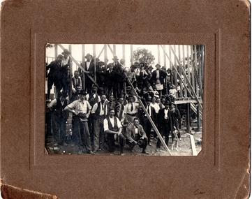 Southern Sherbrooke Historical Society Inc.
Photograph, Watson's Photos, Belgrave, Building Austral Hall, Belgrave, 1920
Black and White photo on a brown cardboard mount, showing a large group of men (about 30) and children (about 6) in front of and on the wooden frame of the partially constructed Belgrave Catholic Church Hall, Austral Hall, corner of (now) Reynolds Lane & Burwood Highway. The men are dressed in various combinations of hats, ties, shirts, jackets, trousers and work aprons. Some have tool belts or are holding hammers and other tools. Two small girls are seated on their fathers' laps. A man is sitting on his haunches at the front. He is wearing a suit and loose bow tie and holding a hat. He appears to be an official. Another man is patting or holding a dog. The building seems to have two walls partially constructed. There are trees visible in the background which are on the high side of the main road of Belgrave. A moulded brown cardboard mount measures 24.7 X 20.00. On the reverse side is written in pencil, 'Building Church hall/ at/ Belgrave/ Saturday 11th Dec 1920.' There is a stamped business name which reads 'Watson's/ photos/ Belgrave.' The Hall was built by largely volunteer labour as the Austral Hall, financed largely by Harry Luscombe's dances and functions. The land was donated by the Buckley Family. On the reverse side is written in pencil, 'Building Church hall/ at/ Belgrave/ Saturday 11th Dec 1920.' There is a stamped business name which reads 'Watson's/ photos/ Belgrave.' -
 Ballarat Tramway Museum
Document - Roster, State Electricity Commission of Victoria (SECV), "Rotation Roster 11th January 1971", Jan. 1971
Yields information about the rostering of crews for a specific week, which staff member undertook which shift or table, for both conductors and motormen.Typed - carbon copy - sheet foolscap size, titled "Rotation Roster 11th January 1971", dated 4th January 1971. Shows the allocation of tables to the various crews, including reallocations and those on Annual and Sick leave or work cover. See also Reg Item 3634 for a May 1969 sheet - not all names survived. Has been ruled to divide the sheet. Turnball A Hamilton N Reynolds H Thompson D Maher J Ward W Smerdon H Billman J Knight R Robe N Williams T Davies W O'Leary D Nancarrow W Courtney R Gill W Blackman M Van Rooy E Cahill M Lake E Williams R Reed A Domaschenz D Wallis I Morris A Munn B Hall R Hunt N Bird L Jeffreys A Van Rooy A McGregor D Van Oorschot Seagrave W Knight H Chambers D Davies S Mason J Tierney L Mercer A Walker L Trenfield I Powell D McMahon L Melville Tuddenham Butler K Morris R Newell W Everett D trams, tramways, rosters, personnel -
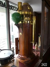 Flagstaff Hill Maritime Museum and Village
Binnacle, Early to mid 20th Century
Mr John Wilson Gillie was born on the 31st of March 1864. On the 31st of July 1880 he was apprenticed for four years to J.J. Wilson and Sons, Nautical Instrument Makers of Sunderland. Following the apprenticeship he spent six months to a year as an ‘improver’ in Glasgow, and then started a new company ‘Wilson and Gillie’ in North Shields. At this time sail had just given way to steam and wooden ships to steel, and the railways were competing with colliers for the carrying of coal from the North East of England to London and the South. In 1858 only seven out of 44 shipyards on the Tyne were using iron, but by 1862 there were ten, employing around 4,000 men. These changes had a significant effect on nautical instrument manufacturers, as the magnetic compass for a wooden sailing vessel was very simple and required little in the way of compensation. For steel vessels much more was required and this was a period of great development, both in the compass bowl and the binnacle in which it was housed. In 1870 Sir William Thomson (later Lord Kelvin) designed his dry card standard compass, which completely replaced all previous designs. Wilson and Gillie started as agents for the Thomson compass, but later J.W. Gillie, using similar principles, redesigned the compass suspension and patented the ‘UNIT’ standard compass. It became popular with local shipowners and shipbuilders. In 1910 the firm of John Lilley and Son (which had been established in London in 1812), found themselves in financial difficulties and were saved with the help of John Wilson Gillie, who established, on the 8th of August 1911, a new firm of John Lilley and Son Limited. John Lilley and Son had been the sole London agents for Sir William Thomson, a very enviable position during this period, when the Thomson compass led the field. Unfortunately, Mr. Lilley had quarreled with the Glasgow company, who withdrew the agency and established their own branch in London (later to become Kelvin White and Hutton). On November 7th 1913, the firm of John Lilley and Son Limited of London amalgamated with Wilson and Gillie of North Shields, and after this date instruments manufactured by the two companies bore the name John Lilley and Son Limited of London and North Shields. During the 1930s many of the London nautical instrument makers were in difficulties, including John Lilley and Son Limited and Reynolds and Son, Dobbie and Clyde Limited, and Mr. J.W. Gillie arranged an amalgamation between these two companies. The new firm became Lilley and Reynolds Limited. In 1943, with estate duties in mind, the North Shields company was reconstituted and took the name of John Lilley and Gillie Limited, although the shareholders, directors and personnel remained unchanged In the early 1970s Lilley and Gillie developed close links with Observator in Rotterdam, who manufactured one of the first fully reliable transmitting magnetic compass systems. The Observator shareholders, Holland America Line, bought the share capital of John Lilley and Gillie Limited., but retained all the personnel and the directors. (See Links for more information)A significant item of early 20th century marine navigational equipment made by a leading manufacturer in the field from a company that is still producing marine navigational instruments today. John Lilleys company began in 1812 growing at a time when the transition of compasses from timber ships, to steel vessels. Compasses at this time required a method of compensation to allow their inclusion in steel vessels without magnetic deviation. This therefore was a period of great development, both in the compass bowl and the binnacle in which it was housed and the Lilley company were leaders in the field. Ships binnacle, wood with brass fittings, consists of 2 brass lamp holders, place for compass, Also has an inclinometer with a scale 40 to 0 to 40, one red and one green iron Kelvin compensation balls, one on each side of binnacle denoting port and starboard, a brass cylinder attached perpendicular at the rear for storing a Flinders Bar, 2 hinged cupboards containing adjustable wooden racks with drilled holes in them to hold iron Heeling error magnets.Textured brass plate attached to front stating "JOHN LILLEY & SON LTD (WILSON & GILLIE), NAUTICAL INSTRUMENT MAKERS, NORTH SHIELDS" . Inclinometer has "JOHN LILLEY & SON LTD (Wilson & Gillie) LONDON & NORTH SHIELDS" engraved. flagstaff hill, warrnambool, shipwrecked-coast, flagstaff-hill, flagstaff-hill-maritime-museum, maritime-museum, shipwreck-coast, flagstaff-hill-maritime-village, binnacle, john lillie & son ltd, compass -
 Eltham District Historical Society Inc
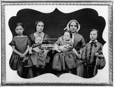
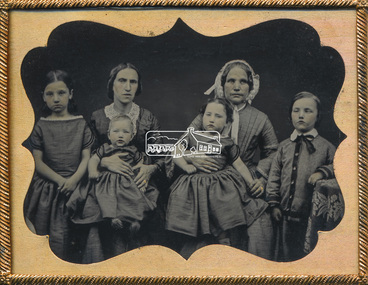
Negative - Photograph, Members of the Hill family, early Eltham settlers, c.1860
Mrs Georgina Hill (wife of Henry), nee Reynolds (of Research, Vic.) in cap [possibly misidentified by donor - see note below] with Mrs Isaac Hill and her children (left to right) Amelia Hill, (born 1853) Mrs Isaac Hill with baby Isaac (born 1860, Eltham) on her lap. Mary Jane Hill (born 1857, Eltham) seated on Mrs Henry Hill's lap and Bob Hill. The Hill family were early settlers of the Eltham area. Daguerreotype photo enclosed in a leather bound clam shell box with felt lining and gold trim. Donated by Mrs Ivy Edna Hill, 4/1 Bridge Street, Eltham, 4 June 1966 and includes copy of her note identifying the people. Daguerreotypes were one of the first forms of early photographs. They initially appeared in Europe in 1839 and were produced in large numbers to the early 1850s but were superseded by more modern and flexible forms of technology by 1860. The photo was usually formed on a thin copper plate with light sensitve silver iodide. They have a mirror-like appearance and the image itself was mirrored. They were usually inserted into a case or frame made of wood bound in leather or velvet and cost about one guinea in Australia, the equivalent of a week's wages. With the advent of the gold-rush and growing population came an increase in numbers of photographers both studio and travelling. The daguerreotype process was protected by patents and could only result in a single image from which no copies could be made. With new technology involving wet colloidion glass plate negatives and albumen paper prints of which multiple copies could be produced at significantly reduced cost, the dauguerreotype quickly fell out of favour. An accompanying note with the photo written by Edna Hill of 4/1 Bridge Street Eltham dated 4 June 1966 states: "Dear Mr Watson, I think the enclosed old time photograph will be of interest to you. It would have been taken about 1860. The two ladies are the wives of the original pioneers of the Hill family. The one in the cap was the wife of Henry Hill, the other of Isaac Hill. The children are those of Mrs Isaac Hill, and grandchildren to Henry Hill. The little girl on the left is Amelia, the baby Isaac, the second girl is Mary Jane, and the boy on the right is Bob Hill. They grew up tobe Uncles and Aunts of my late husband. I greatly appreciated a letter received a few months ago per Cr Pelling, from the Shillinglaw Cottage Committee. Yours sincerely, Edna Hill" Victorian birth registrations show Mary Jane Hill was born 1857 in Eltham (9879 / 1857) and Isaac Hill at Eltham in 1860 (1972/1860) NOTE: Mrs Isaac Hill was Ellen Fitzsimons (1834-1863), mother to Henry Hill. Mrs Georgina Hill, wife of Henry cannot be the lady in the cap as she was not born till 1864. Georgina Reynolds (1864-1927) married Henry Hill (1862-1948) in 1884. This lady has significant wrinkling of the face, especially around her mouth. It is possible that she is the mother of Mrs Isaac Hill (Ellen Fitzsimons) who was Isabella Fitzsimons (nee Ferguson).This photo forms part of a collection of photographs gathered by the Shire of Eltham for their centenary project book,"Pioneers and Painters: 100 years of the Shire of Eltham" by Alan Marshall (1971). The collection of over 500 images is held in partnership between Eltham District Historical Society and Yarra Plenty Regional Library (Eltham Library) and is now formally known as 'The Shire of Eltham Pioneers Photograph Collection.' It is significant in being the first community sourced collection representing the places and people of the Shire's first one hundred years.Digital image 4 x 5 inch B&W Negsepp, shire of eltham pioneers photograph collection, eltham, hill family, research (vic.), women, amelia hill, bob hill, daguerreotype, early settlers, georgina hill (nee reynolds), isaac hill, mary jane hill, mrs henry hill, mrs isaac hill, ellen hill (nee fitzsimons), isabella fitzsimons (nee ferguson) -
 Eltham District Historical Society Inc
Photograph - Daguerreotype Photo Case, Members of the Hill family, early Eltham settlers, c.1860
Mrs Georgina Hill (wife of Henry), nee Reynolds (of Research, Vic.) in cap [possibly misidentified by donor - see note below] with Mrs Isaac Hill and her children (left to right) Amelia Hill, (born 1853) Mrs Isaac Hill with baby Isaac (born 1860, Eltham) on her lap. Mary Jane Hill (born 1857, Eltham) seated on Mrs Henry Hill's lap and Bob Hill. The Hill family were early settlers of the Eltham area. Daguerreotype photo enclosed in a leather bound clam shell box with felt lining and gold trim. Donated by Mrs Ivy Edna Hill, 4/1 Bridge Street, Eltham, 4 June 1966 and includes copy of her note identifying the people. Daguerreotypes were one of the first forms of early photographs. They initially appeared in Europe in 1839 and were produced in large numbers to the early 1850s but were superseded by more modern and flexible forms of technology by 1860. The photo was usually formed on a thin copper plate with light sensitve silver iodide. They have a mirror-like appearance and the image itself was mirrored. They were usually inserted into a case or frame made of wood bound in leather or velvet and cost about one guinea in Australia, the equivalent of a week's wages. With the advent of the gold-rush and growing population came an increase in numbers of photographers both studio and travelling. The daguerreotype process was protected by patents and could only result in a single image from which no copies could be made. With new technology involving wet colloidion glass plate negatives and albumen paper prints of which multiple copies could be produced at significantly reduced cost, the dauguerreotype quickly fell out of favour. An accompanying note with the photo written by Edna Hill of 4/1 Bridge Street Eltham dated 4 June 1966 states: "Dear Mr Watson, I think the enclosed old time photograph will be of interest to you. It would have been taken about 1860. The two ladies are the wives of the original pioneers of the Hill family. The one in the cap was the wife of Henry Hill, the other of Isaac Hill. The children are those of Mrs Isaac Hill, and grandchildren to Henry Hill. The little girl on the left is Amelia, the baby Isaac, the second girl is Mary Jane, and the boy on the right is Bob Hill. They grew up tobe Uncles and Aunts of my late husband. I greatly appreciated a letter received a few months ago per Cr Pelling, from the Shillinglaw Cottage Committee. Yours sincerely, Edna Hill" Victorian birth registrations show Mary Jane Hill was born 1857 in Eltham (9879 / 1857) and Isaac Hill at Eltham in 1860 (1972/1860) NOTE: Mrs Isaac Hill was Ellen Fitzsimons (1834-1863), mother to Henry Hill. Mrs Georgina Hill, wife of Henry cannot be the lady in the cap as she was not born till 1864. Georgina Reynolds (1864-1927) married Henry Hill (1862-1948) in 1884. This lady has significant wrinkling of the face, especially around her mouth. It is possible that she is the mother of Mrs Isaac Hill (Ellen Fitzsimons) who was Isabella Fitzsimons (nee Ferguson).Early pioneer settlers of ElthamAntique daguerreotypes in hinged gold frame, glass encased in a small clam-shell box lined with padded red felt and with catchamelia hill, bob hill, early settlers, eltham, hill family, isaac hill, mary jane hill, mrs henry hill, mrs isaac hill, daguerreotype, georgina hill (nee reynolds), research (vic.), sepp, shire of eltham pioneers photograph collection, women, ellen hill (nee fitzsimons), isabella fitzsimons (nee ferguson) -
 Eltham District Historical Society Inc
Photograph - Aerial Photograph, Landata, Eltham; Crown Allotment 15, Section 5, Parish of Nillumbik (Stokes Orchard Estate), Nov. 1931
Centred over present day Reynolds Road and Mount Pleasant Road, Eltham (including Diosma Rd, Stokes Pl, Nyora Rd and Eucalyptus Rd) Historic Aerial Imagery Source: Landata.vic.gov.au Aerial Photo Details: Project No :1931 Project : MALDON PRISON Run : 21 Frame : 3160 Date : 11/1931 Film Type : B/W Camera : F8 Flying Height : 11000 Scale : 18860 Film Number : 60 GDA2020 : 37°43'31"S, 145°10'20"E MGA2020 : 338912, 5823086 (55) Melways : 22 E8 (ed. 42) A History of the Development of Crown Allotment 15, Section 5, Parish of Nillumbik – Stokes Orchard Crown Allotment 15, Section 5, Parish of Nillumbik (CA15) is a square allotment of 158 acres or approximately a quarter of a square mile. It lies just beyond the eastern end of Pitt Street, south of Nyora Road to the northern end of Eucalyptus Road and extends east from Eucalyptus Road to Reynolds Road. The topography of CA15 is generally steep, sloping up to a hill near the centre of the land, the ridgeline passing through the properties along the southern side of Diosma Road. Eucalyptus Road is a straight north-south road with its northern end at the north west corner of CA15. Until the end of the 1970s this road was an un-named Government Road and was largely not open to traffic. With residential development in the 1970s the road was constructed, and the council allocated the name obviously in recognition of the predominant species of the local bushland. CA15 was purchased from the Crown by George D’Arley Boursiquot, a prominent Melbourne printer, on 28th October 1852. On November 23, 1922, former Member for Gippsland and Melbourne Real Estate Agent, Hubert Patrick Keogh purchased the allotment then sold it March 13, 1925, to local farmer, Robert David Taylor, a former Shire of Eltham Councillor (1911-1920) and Shire President (1919). Taylor had extensive land holdings stretching west towards Bible Street and Main Road. The Taylor home was situated at the top of the hill in Bible Street at present day 82 Bible Street. At the time of Taylor’s purchase in 1925, CA15 was subdivided into 48 lots that could be described as small rural properties or large residential lots. A typical lot size was one hectare or 2.5 acres. The subdivision created two roads, Nyora Road, and Diosma Road, each following an irregular alignment between Eucalyptus and Reynolds Roads. However, the lots were not sold off separately nor were the roads constructed. The land effectively remained as one parcel for many further years. Robert David Taylor died November 30, 1934, and probate was granted to his son of the same name, Robert David Taylor of Bible Street, Salesman and William McLelland Vance Taylor of 73 Emmeline Street, Northcote, Clerk, with the transfer of the land into their names on July 8, 1935. Frank Stokes worked as a qualified accountant at Kennons leather factory in Burnley, while living at 1 Thomas Street, Mitcham. He suffered from migraines and wanted to return to working the land (he had previously worked on farms and orchards since coming to Australia from England in 1926, both in WA and Vic.). He first travelled to the district by train in July 1942 to find land with the intention to establish an orchard. By chance he met Arthur Bird of Bird Orchard (bounded by Pitt Street, Eucalyptus Road, and Wattle Grove) and they got talking over their common interest. Arthur put Frank up for the night and pointed out the land, 158 acres- part of the Taylor Estate- £900, Crown Allotment 15, Section 5, Parish of Nillumbik (CA15) somewhat diagonally opposite Bird Orchard. Stokes applied through the Riverina Agency to purchase the land who in turn applied for permission from Canberra to sell as there was a new government regulation introduced during the Second World War banning land sales except for immediate production. Stokes obtained a loan on his Mitcham house of £600 @ 5% and paid £450 deposit with quarterly payments of £15 spread over 5 years. Stokes was assisted and advised by Arthur Bird who farmed the neighbouring orchard. In early 1943 Stokes took possession and would catch the train out to Eltham on Fridays after work and began building a hut on the corner of Nyora Road and the Government Road (Eucalyptus Road) for shelter and to lock up tools. He established an orchard on the central western part of the land through the centre of which ran a natural waterway (part of the present-day linear park) and was able to pay a neighbour (Hawkins) to help with clearing and fencing 25 acres, and with a horse and single furrowed plough, planted approximately 2,500 fruit trees - cherries, peaches, plums, almonds, pears, apricots and lemons as well as a few apples and oranges; a massive task. Aerial photographs from the 1940s through to the 1990s clearly show the orchard with most of the larger CA15 site remaining as natural bushland. A huge problem was hares and rabbits eating all the new buds off the tiny trees. As well as laying poison he painted the trees with a mixture of cow manure and lime, often working by moonlight. Procurement of wire and wire netting was difficult because of the war but after much effort he obtained a permit from the Agricultural Department for supplies in March 1944. In February 1945 Stokes applied for a permit to build a “packing shed” as no house building was allowed. It was to be 33 feet x 21 feet and cost £312. It was constructed mostly from second-hand materials, which were hard to obtain, especially iron for roofing. Stokes finished work at Kennons on October 31, 1945, and in March 1946 he sold the family home at Mitcham for £1,230 plus £170 for furniture. On May 15, 1946, title to the CA15 property was issued to Frank Howard Alfred Stokes, Orchardist and Gladys Ethel Stokes, Married Woman, both of Pitt Street, Eltham. The family of five then moved into the very unfinished “packing shed” at Eltham, which was a struggle to weatherproof. Eventually rooms were divided off and lined with hessian bags and whitewashed. Their income was firewood (cut and sold), selling rockery stones and cut Sweet Bursaria. (It was discovered during the 1940s that Sweet Bursaria contained the sunscreen compound Aesculin. The RAAF utilised this compound from Sweet Bursaria during WW2 for pilots and gunners.) The orchard’s first fruit sale was a half-case of Le Vanq peaches in December 1947 for the price of 8 shillings. In 1956 plans for house were drawn and Glen Iris bricks purchased (1956 Olympic Rings variant). The building of the house commenced in 1957 - 12 feet of original packing shed was removed – and was completed in 1959. Water was connected from newly built pressure storage on the property at the end of 1959 and the electricity connection for the first time at 3pm on April 29, 1960. The house remains to present day (somewhat modified) at 1 Nyora Road, home to Nyora Studio Gallery. On occasions, spare remnants of the 1956 bricks have been known to be unearthed in gardens on the estate as they were utilised by Frank Stokes to fill in rabbit holes. On May 26, 1950, a parcel of land was compulsorily acquired by the Melbourne and Metropolitan Board of Works on the hilltop to establish an easement for a high-level service reservoir to augment Eltham’s water supply. The project also included pipe tracks for the necessary water mains. The reservoir has now been superseded by higher level water tanks east of Reynolds Road and its former site is now a public reserve. On November 27, 1964, the State Electricity Commission served notice to compulsorily acquire a further parcel through the eastern part of the land for a major electricity transmission line that augmented supply from the La Trobe Valley to Melbourne. The easement was registered February 11, 1966. The easement was widened July 18, 1969 for a second transmission line to be constructed. In 1971 Melbourne Metropolitan Planning Scheme amendments adopted Nyora Road as the boundary between a residential zone to the north and a rural zone to the south. This determined the future development of the land. In the mid-1970s the Shire of Eltham divided the orchard into numerous rate-able parcel lots, the 48 lots having been established in 1925 and the subsequent rates assessment proved unsustainable for Stokes. He commenced selling lots outside the boundary of the orchard, north of Diosma and South of Nyora. However shortly later the land between Nyora and Diosma Roads and west of the electricity easement was sold and subdivided into residential lots, a housing development by Macquarie Builders and marketed as the Stokes Orchard Estate. New streets were created, and most were named after trees, although one, Stokes Place, commemorates the former owners. The development was undertaken in two stages; Stage 1 (1975) encompassing Scarlet Ash Court, Ironbark Close and Peppermint Grove bounded by Nyora and Eucalyptus roads and Stage 2 (1978) encompassing Stokes Place, Orchard Way, The Crest and The Lookout bound by Nyora and Diosma roads. The developer, Macquarie Builders went bankrupt shortly after the release of Stage 2 leaving many purchasers to fend for themselves and arrange for their own independent builders. There were also difficulties with sewerage for the land immediately south of Diosma Road and so the conventional residential lots were abandoned in favour of larger lots. The development of Orchard Way, The Crest and The Lookout did not proceed as planned and the proposed lots were incorporated into five-acre parcels instead. These included a low-density group housing development by the Graves family and the award winning Choong House (1983) with Gordon Ford developed garden immediately next door situated on the ridge of the hill nestled amongst the original bush, Eucalypt trees and Sweet Bursaria. In 1994, Nillumbik Shire Council applied Significant Environment and Significant Landscape overlays upon the properties on the south side of Diosma Road to ensure protection of this natural bush garden environment. With the arrival of the sewer along Diosma Road in the 1990s, most of these five-acre parcels have since been subdivided multiple times. The Choong house presently sits on a 2.7-acre property, which in 2022 Nillumbik Council nominated for Cultural Significance Heritage protection and is considered potentially significant at State level. The Stokes family were also associated with the Eltham Christian Church. In the 1970s this church had met in temporary premises in Eltham. Lots of the original 1925 subdivision remained south of Nyora Road and a number of these lots were utilized for the Eltham Christian School, which was established by the Eltham Christian Church in 1981. The school operated on this site until 2000. The premises are now used by The Vine Baptist Church. By the mid-1980s the whole of CA15 had been developed for residential and school purposes, except for the sections north of Diosma Road and between the transmission lines and Reynolds Road. Sewerage issues had been resolved for the section north of Diosma Road and in 1987 it was in the process of being subdivided into residential lots. The development coincided with the discovery of colonies of the rare and endangered Eltham Copper Butterfly on the site. This resulted in a community and political campaign to save the butterfly habitat. With the co-operation of the land developer the subdivision was altered to create two bushland reserves in the critical butterfly habitat areas. In the late 1980s the State Government was investigating options for establishing a metropolitan ring road link between Diamond Creek and Ringwood. The chosen route was adjacent to Reynolds Road and so this created a freeze on development of CA15 between Reynolds Road and the electricity easement. The ring road proposal was eventually abandoned, and this part of the land was subdivided into low density residential lots. Diosma Road has been discontinued at the electricity easement and the eastern part incorporated into View Mount Court with access from Reynolds Road. The whole of CA15 has now been developed for residential or associated purposes, ranging from conventional density to quite low density south of Nyora Road. Some remnants of the orchard remain, a few cherry trees on the Graves property and a lone apple tree in Stokes Place. The butterfly reserves comprise significant areas of remnant bushland. Linear reserves through the estate link with central Eltham via the Woodridge linear reserve and with Research along the electricity easement. CA15 as it exists today has a complicated history of rural use, Government acquisition, urban development, and community action. References: • “Stokes Orchard, an incomplete history”; Russell Yeoman with Doug Orford • Correspondence, Beryl Bradbury (nee Stokes) • Aerial Photographs, 1931-1991, Landata (landata.vic.gov.au) • Certificate of Title, Vol. 4930 Fol. 985900 • Plan Number LP 10859 aerial photo, diosma road, eltham copper butterfly, eucalyptus road, ironbark close, nyora road, peppermint grove, peter & elizabeth pidgeon collection, power transmission lines, reynolds road, scarlet ash court, stokes orchard estate, stokes place, woodridge estate, frank stokes -
 Ringwood and District Historical Society
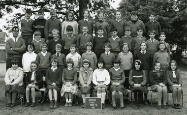
Photograph, Ringwood State School - Grade 5A, 1967
Black and white photograph "Attached to photograph" Back Row - L to R: Richard Fly, Graeme Reynolds, Colin Grieves, Pam Cleary, ?, Susan Broadly, Dean Barnes, Mikaly Kovendiachou, Peter Hayes. 2nd Row - L to R: Teacher Fred Rogers, ?, Tino Pekkarinen, Glen Pope, David Green, James Taylor, Eric Culmer, Bruce Fuller, Michael Brown, Michael Grayling, David ?. 3rd Row - L to R: Jennifer Walters, Elizabeth Harding, Elizabeth Doig, Susan Little, Sandra Mitchell, Janice Louttit, Jenny Smith, Annette Lighthouse, Linda Cook. Front Row: Bevalla Conner, ?, Julie Reid, Sandra Cook, Lynette Lightfoot, Wendy Thomas, Joy Hall, Roslyn Darian, Josie Trotter, Jenny Critchley. -
 Ringwood and District Historical Society
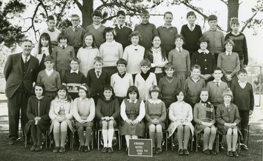
Photograph, Ringwood State School - Grade 6B, 1968
Black and white photograph "Attached to photograph" List of names, supplied by Jenny Hall nee Parker. Back Row - L to R: Glenn Pope, David Green, Russell Rogers, Peter Hayes, Colin Greeves, Ian Barnes, Graeme Reynolds, Peter ?, Keith Lancaster. 2nd Row - L to R: Jenny Hall, Kerry Malcolm, Lucia Ziole, Kim Jordan, Lynda Cook, Joyce Weaver, Janice Louttit, Joy Hall, Pam Weeks. 3rd Row - L to R: Michael Brown, ?, John Moore, Bruce Pumpa, ?, Gary Saffron, Daford Roberts, David ?, Mark Hopping. Front Row - L to R: Roslyn Dorien, Josie Trotter, Lynette Lightfoot, Jenny Walters, Beulah Connell, Cheryl Smilie, Maria Maraffa, Bronwyn Kenny, Margo Johnstone. Teacher : Mr Treloar -
 Flagstaff Hill Maritime Museum and Village
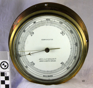
Instrument - Barometer, 1952
Mr John Wilson Gillie was born on the 31st of March 1864. On the 31st of July 1880 he was apprenticed for four years to J.J. Wilson and Sons, Nautical Instrument Makers of Sunderland. Following the apprenticeship he spent six months to a year as an ‘improver’ in Glasgow, and then started a new company ‘Wilson and Gillie’ in North Shields. At this time sail had just given way to steam and wooden ships to steel, and the railways were competing with colliers for the carrying of coal from the North East of England to London and the South. In 1858 only seven out of 44 shipyards on the Tyne were using iron, but by 1862 there were ten, employing around 4,000 men. These changes had a significant effect on nautical instrument manufacturers, as the magnetic compass for a wooden sailing vessel was very simple and required little in the way of compensation. For steel vessels much more was required and this was a period of great development, both in the compass bowl and the binnacle in which it was housed. In 1870 Sir William Thomson (later Lord Kelvin) designed his dry card standard compass, which completely replaced all previous designs. Wilson and Gillie started as agents for the Thomson compass, but later J.W. Gillie, using similar principles, redesigned the compass suspension and patented the ‘UNIT’ standard compass. It became popular with local shipowners and shipbuilders. In 1910 the firm of John Lilley and Son (which had been established in London in 1812), found themselves in financial difficulties and were saved with the help of John Wilson Gillie, who established, on the 8th of August 1911, a new firm of John Lilley and Son Limited. John Lilley and Son had been the sole London agents for Sir William Thomson, a very enviable position during this period, when the Thomson compass led the field. Unfortunately, Mr. Lilley had quarreled with the Glasgow company, who withdrew the agency and established their own branch in London (later to become Kelvin White and Hutton). On November 7th 1913, the firm of John Lilley and Son Limited of London amalgamated with Wilson and Gillie of North Shields, and after this date instruments manufactured by the two companies bore the name John Lilley and Son Limited of London and North Shields. During the 1930s many of the London nautical instrument makers were in difficulties, including John Lilley and Son Limited and Reynolds and Son, Dobbie and Clyde Limited, and Mr. J.W. Gillie arranged an amalgamation between these two companies. The new firm became Lilley and Reynolds Limited. In 1943, with estate duties in mind, the North Shields company was reconstituted and took the name of John Lilley and Gillie Limited, although the shareholders, directors and personnel remained unchanged In the early 1970s Lilley and Gillie developed close links with Observator in Rotterdam, who manufactured one of the first fully reliable transmitting magnetic compass systems. The Observator shareholders, Holland America Line, bought the share capital of John Lilley and Gillie Limited., but retained all the personnel and the directors. Tug Melbourne: The barometer was salvaged from a 496-ton tug that had been built in 1952 and had sunk in Port Philip Bay on the 9th of August 1972 after a collision with the SS Nieuw Holland, in 1973 it had been raised and scraped at this time the barometer was salvaged. The tug had been renamed from the Howard Smith to the “Melbourne” after the Adelaide Steamship Co was taken over by Howard Smith& Co, who were heavily involved in towage, salvage and the stevedoring industries in 1961.The significance is that the item was on a vessel that was evolved in a serious collision in Port Philip Bay in 1972. It is linked with the activities of the Port at that time and helps to form a picture of what the maritime industries that operated from Port Melbourne were like and the activities that stevedore and towage companies underwent.Ship Barometer, in brass caseInscribed "Compensated" , "John Lilley & Gillie Ltd London & North Shields." and "Millibars".flagstaff hill, warrnambool, shipwrecked coast, flagstaff hill maritime museum, maritime museum, shipwreck coast, flagstaff hill maritime village, great ocean road, barometer, ship's barometer, weather instrument, john lilley & gillie ltd, shipwreck artefact, the tigboat melbourne, north shields, howard smith, the melbourne, salvage