Showing 1579 items matching "shopping centres"
-
 Whitehorse Historical Society Inc.
Photograph, Street naming
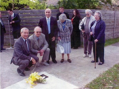
... their christian names and are directly behind the Rangeview Shopping... the Rangeview Shopping Centre Street names Till Alwyn Loftus Owen Fenton ...The dignitaries in front are (from left), Hon Bruce Scott Minister for Veteran Affairs, Raleigh Armstrong, Hon Phillip Barelli MHR Deakin, Pia Armstrong and other RSL members. The young Mitcham men who did not return from WW2 were Alwyn Till, Owen Loftus, Ross Fenton, Ronald Peake,and Brian Cox. The streets bear their christian names and are directly behind the Rangeview Shopping CentreColoured photo copy of nine people at the laying of a wreath near a plaque in the footpath near the Rangeview shopsstreet names, till alwyn, loftus owen, fenton ross, peake ronald, cox brian, scott bruce hon., barelli phillip hon., armstrong raleigh, armstrong pat., world war 1039-1945, plaques -
 Greensborough Historical Society
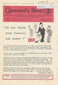
Newsletter, Greenhills and North Greensborough Progress Association, Community News: official journal of the Greenhills and Nth. Greensborough Progress Association and the Apollo Parkways Progress Association. 4th July, 1977. Edition No. 6/77, 04/07/1977
... -Johnson, This and that, News from the Shopping Centre Action...-Johnson, This and that, News from the Shopping Centre Action ...So you think your Council has power!, Cameo of Faye Wilkes-Johnson, This and that, News from the Shopping Centre Action Committee, Letter to the Editor, If you have trouble sleeping... read on, Diamond Valley Arts Awards 1977, A significant change in 1977, From the Council Chamber, Can childbirth be easier?, Amnesty International... Idi Amin, and you. A digital copy of this Newsletter is available from Greensborough Historical Society.Newsletter, 19 p., illus.greenhills and north greensborough progress association, greenhills, apollo parkways progress association, apollo parkways -
 Ringwood and District Historical Society
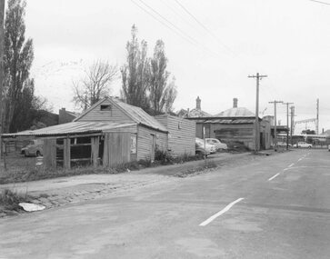
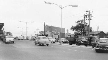
Photograph, Maroondah Highway Central, Ringwood. Buildings at rear of property, N.E. corner of Adelaide Street and Maroondah Highway, 1963. (Eastland Litigation Photo), May 1963
... Shopping Centre and Eastland 1858-2008" by Richard Carter, Bounce... Shopping Centre and Eastland 1858-2008" by Richard Carter, Bounce ...This series of SS0380 photos are part of the "Eastland Litigation" launched in 1962 by the Whitehorse Traders Co-operative Association (WTCA), against the Ringwood Council's Interim Development Order of 1960. WTCA sought "orders from the Supreme Court of Victoria that the planning scheme was invalid" - See "The Eastland Litigation" chapter in "From Horse Shoes to High Heels - Ringwood Shopping Centre and Eastland 1858-2008" by Richard Carter, Bounce Books 2009.Black and White Photograph (2 copies)Written on back of photograph: "Photo showing buildings at rear of property, N.E. corner of Adelaide Street and Maroondah Highway". Stamps on back of photograph read, 'In the Supreme court, 13 Aug. 1963', and 'Edwin G. Adamson....May '63.' -
 Ringwood and District Historical Society
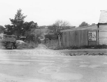
Photograph, Edwin G. Adamson A.R.P.S, Maroondah Highway Central, Ringwood. Lane running from Adelaide St. to Warrandyte Rd.Ringwood 1963 (Eastland Litigation Photo)
... Shopping Centre and Eastland 1858-2008" by Richard Carter, Bounce... Shopping Centre and Eastland 1858-2008" by Richard Carter, Bounce ...This series of SS0380 photos are part of the "Eastland Litigation" launched in 1962 by the Whitehorse Traders Co-operative Association (WTCA), against the Ringwood Council's Interim Development Order of 1960. WTCA sought "orders from the Supreme Court of Victoria that the planning scheme was invalid" - See "The Eastland Litigation" chapter in "From Horse Shoes to High Heels - Ringwood Shopping Centre and Eastland 1858-2008" by Richard Carter, Bounce Books 2009.Black and White Photograph (2 copies)Written on back of photograph: "The lane running from Adelaide St. to Warrandyte Rd. Now Civic Place. Right-hand side where Jack Orr used to make clothes hoists. Left-hand side verging on plumber - S. Hunt then Horman & Woolhouse.' Stamp on photograph reads, 'Edwin G. Adamston A.R.P.S. Chartres House, Melbourne, Date May '63'. And on one copy stamped "IN THE SUPREME COURT E.W.L. 13 AUG 1963" -
 Ringwood and District Historical Society
Photograph, Edwin G. Adamson A.R.P.S, Maroondah Highway Central, Ringwood. Looking east from Ringwood Street 1963. (Eastland Litigation Photo), May 1963
... Shopping Centre and Eastland 1858-2008" by Richard Carter, Bounce... Shopping Centre and Eastland 1858-2008" by Richard Carter, Bounce ...This series of SS0380 photos are part of the "Eastland Litigation" launched in 1962 by the Whitehorse Traders Co-operative Association (WTCA), against the Ringwood Council's Interim Development Order of 1960. WTCA sought "orders from the Supreme Court of Victoria that the planning scheme was invalid" - See "The Eastland Litigation" chapter in "From Horse Shoes to High Heels - Ringwood Shopping Centre and Eastland 1858-2008" by Richard Carter, Bounce Books 2009.Black and white photographWritten on back of photograph: "Photo showing cars parked and travelling along M'dah Hway" Stamped on back of photograph, 'Edwin G. Adamson...May 63'. -
 Ringwood and District Historical Society
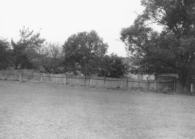
Photograph, Edwin G. Adamson A.R.P.S, Maroondah Highway Central, Ringwood. Vacant land rear of Ringwood Oval 1963 (Eastland Litigation Photo), May 1963
... Shopping Centre and Eastland 1858-2008" by Richard Carter, Bounce... Shopping Centre and Eastland 1858-2008" by Richard Carter, Bounce ...This series of SS0380 photos are part of the "Eastland Litigation" launched in 1962 by the Whitehorse Traders Co-operative Association (WTCA), against the Ringwood Council's Interim Development Order of 1960. WTCA sought "orders from the Supreme Court of Victoria that the planning scheme was invalid" - See "The Eastland Litigation" chapter in "From Horse Shoes to High Heels - Ringwood Shopping Centre and Eastland 1858-2008" by Richard Carter, Bounce Books 2009.Black and white photograph (2 copies)Written on back of photograph: "Photo of the vacant land at rear of oval, i.e. land in private occupation." Stamp on back of photograph, 'Edwin G. Adamson...May 63'. -
 Ringwood and District Historical Society
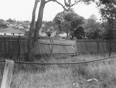
Photograph, Edwin G. Adamson A.R.P.S, Maroondah Highway Central, Ringwood. Vacant land, rear of the oval, 1963. (Eastland Litigation Photo)
... Shopping Centre and Eastland 1858-2008" by Richard Carter, Bounce... Shopping Centre and Eastland 1858-2008" by Richard Carter, Bounce ...This series of SS0380 photos are part of the "Eastland Litigation" launched in 1962 by the Whitehorse Traders Co-operative Association (WTCA), against the Ringwood Council's Interim Development Order of 1960. WTCA sought "orders from the Supreme Court of Victoria that the planning scheme was invalid" - See "The Eastland Litigation" chapter in "From Horse Shoes to High Heels - Ringwood Shopping Centre and Eastland 1858-2008" by Richard Carter, Bounce Books 2009.Black and White PhotographWritten on back of photograph: "Photo of the vacant back land, rear of oval, i.e. - land in private occupation." Stamped on rear of photograph, 'Edwin G. Adamson...May 63'. -
 Ringwood and District Historical Society
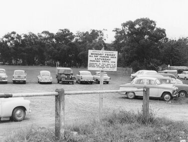
Photograph, Edwin G. Adamson A.R.P.S, Maroondah Highway Central, Ringwood. Ringwood Oval Car Park 1963 (Eastland Litigation Photo), May 1963
... Shopping Centre and Eastland 1858-2008" by Richard Carter, Bounce... Shopping Centre and Eastland 1858-2008" by Richard Carter, Bounce ...This series of SS0380 photos are part of the "Eastland Litigation" launched in 1962 by the Whitehorse Traders Co-operative Association (WTCA), against the Ringwood Council's Interim Development Order of 1960. WTCA sought "orders from the Supreme Court of Victoria that the planning scheme was invalid" - See "The Eastland Litigation" chapter in "From Horse Shoes to High Heels - Ringwood Shopping Centre and Eastland 1858-2008" by Richard Carter, Bounce Books 2009.Black and white photograph (2 copies) Written on back of photograph: "Photo of one of the noticeboards relating to parking on the Oval" Stamp on photograph, 'Edwin G. Adamson...May 63'. -
 Ringwood and District Historical Society
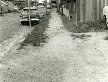
Photograph, Edwin G. Adamson A.R.P.S, Maroondah Highway Central, Ringwood. Adelaide St Footpath - West Side,1963. (Eastland Litigation Photo), May 1963
... Shopping Centre and Eastland 1858-2008" by Richard Carter, Bounce... Shopping Centre and Eastland 1858-2008" by Richard Carter, Bounce ...This series of SS0380 photos are part of the "Eastland Litigation" launched in 1962 by the Whitehorse Traders Co-operative Association (WTCA), against the Ringwood Council's Interim Development Order of 1960. WTCA sought "orders from the Supreme Court of Victoria that the planning scheme was invalid" - See "The Eastland Litigation" chapter in "From Horse Shoes to High Heels - Ringwood Shopping Centre and Eastland 1858-2008" by Richard Carter, Bounce Books 2009.Black and white photograph Written on back of photograph: "Photo of the footpath on West side of Adelaide St, showing how it is unmade and unkempt." Stamp on back of photograph, 'Edwin G. Adamson...May 63'. -
 Ringwood and District Historical Society
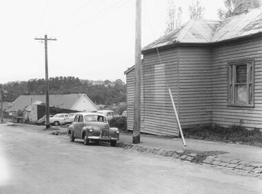
Photograph, Edwin G. Adamson A.R.P.S, Maroondah Highway Central, Ringwood. Rear of condemned dwelling NE Corner of Adelaide St,1963. (Eastland Litigation Photo), 1963
... Shopping Centre and Eastland 1858-2008" by Richard Carter, Bounce... Shopping Centre and Eastland 1858-2008" by Richard Carter, Bounce ...This series of SS0380 photos are part of the "Eastland Litigation" launched in 1962 by the Whitehorse Traders Co-operative Association (WTCA), against the Ringwood Council's Interim Development Order of 1960. WTCA sought "orders from the Supreme Court of Victoria that the planning scheme was invalid" - See "The Eastland Litigation" chapter in "From Horse Shoes to High Heels - Ringwood Shopping Centre and Eastland 1858-2008" by Richard Carter, Bounce Books 2009.Black and White PhotographWritten on back of photograph: "Photo showing rear of dwelling of condemned property NE corner of Adelaide St M/dah Hwy. Stamp on back of photo 'Edwin G. Adamson....May 1963'. -
 Ringwood and District Historical Society
Newspaper, Scrapbook Clipping, Library Collection, Ringwood, Victoria
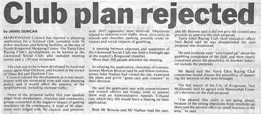
... facilities, at the rear of North Ringwood Shopping Centre. The club... Shopping Centre. The club was to have been developed by local real ...Newspaper Clipping from The Mail, 18-6-1996, P3 - 24 hour TradingMaroondah Council has rejected a planning application for a licensed club complete with 50 poker machines and betting facilities, at the rear of North Ringwood Shopping Centre. The club was to have been developed by local real estate agent Alan Dickson, and located at the corner of Oban Road and Dockson Cres. A total of 96 objections were lodged with the council, and petitions with 2697 signatures were received. -
 Ringwood and District Historical Society
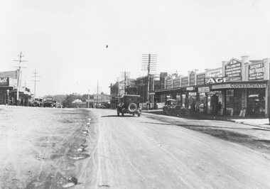
Photograph, Maroondah Highway Central, Ringwood. Maroondah Highway shops, Ringwood - 1927
... unmade road with shops in centre and background....: "Maroondah Highway Shops. Old Town Hall under construction in centre ...Black and white photograph (2 copies)Typed below one photograph: "Maroondah Highway Shops. Old Town Hall under construction in centre - 1927" Image shows unmade road with shops in centre and background. -
 Whitehorse Historical Society Inc.
Article, Rezoning plan riles retailers, 1992
... Shopping Centre Patricia Wilson says the traders object to any... south shopping centre burwood highway vermont south nos 473-493 ...Despite widespread disapproval by traders and residents, Nunawading Council still plans put its draft structure plan for Vermont South Activity Centre on public display.Despite widespread disapproval by traders and residents, Nunawading Council still plans put its draft structure plan for Vermont South Activity Centre on public display. Council owned land on Burwood Highway is earmarked for rezoning to restricted business zone. The draft has designated the area for a mix of office and retail development. it is not intended to duplicate retail services which already exist. Manager of Vermont South Shopping Centre Patricia Wilson says the traders object to any amount of extra retail development.Despite widespread disapproval by traders and residents, Nunawading Council still plans put its draft structure plan for Vermont South Activity Centre on public display.shops, city of nunawading, wilson, patricia, vermont south shopping centre, burwood highway, vermont south, nos 473-493 -
 Ballarat Tramway Museum
Photograph - Digital image, late 1910's
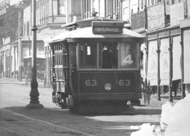
... became Ballarat No. 18. In the background are shops, centre... became Ballarat No. 18. In the background are shops, centre poles ...Yields information about a PMTT tramcar that was sold to Ballarat and an operating member of the BTM fleet.Digital Image of Prahran and Malvern Tramway Trust, Maximum Traction tramcar No. 63 in Glenferrie Road, with destination of Esplanade and Route No. 4 in the window of the tram. Tram later became Ballarat No. 18. In the background are shops, centre poles and blinds on the shops, indicating a summer's day perhaps. Detail from a Rose Series postcard. Possibly late 1910's. See image 2 for original enlarged postcard and high res images. Advised by Mal Rowe that he obtained from the Bob Prentice collection. trams, tramways, pmtt, glenferrie rd, tram 63, tram 18 -
 Melbourne Tram Museum
Letter, Australian Electric Traction Association (AETA), "Transporting Melbourne", 4/12/1996 12:00:00 AM
... Shopping centre, Highpoint West, South bank Route and other... Pier, Westfield Shopping centre, Highpoint West, South bank ...Letter - 8 A4 pages stapled in top left hand corner - AETA to "Transporting Melbourne", Ministry of Transport, dated 4-12-1996 forward comments or making a submission regarding the proposed framework. Endorse the concept, backlog in Melbourne public transport, railway electrification, tramway and light rail extensions; East Malvern Station, Box Hill, Station Pier, Westfield Shopping centre, Highpoint West, South bank Route and other suggestions made regarding re-routing of trams services.trams, tramways, aeta, submissions, new tramway, melbourne, public transport, box hill -
 Eltham District Historical Society Inc
Slide, Pryor Street, Eltham, 25 Jul 1973
... is now a busy shopping centre car park.... is now a busy shopping centre car park. eltham eltham police ...Looking east across Pryor Street towards the Eltham Police Station. The Police purchased the residence at 23 Pryor Street in 1959 to move from the old town centre of the late 1800s to be closer to the new town centre that shifted as a result of the railway opening in 1901. The residential house was renovated to Police requirements and operations commenced from this location in 1961. Diretly opposite and to the left of the Police Station is now a busy shopping centre car park.35 mm colour positive transparency Mount - Agfacolor Service (Blue)eltham, eltham police station, pryor street, streets, houses -
 Melbourne Tram Museum
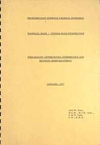
Document - Report, John Knee, "Warragul Road - Toorak Road Intersection", Jan. 1977
... at the intersection, how the shopping centre could be accessed, possible Mall... and shopping redevelopment - Jan. 1977". Prepared by John W Knee ...Report - "proposed East Burwood Tramway Extension - Warragul Road - Toorak Road Intersection - Preliminary Appreciation intersection and shopping redevelopment - Jan. 1977". Prepared by John W Knee for the MMTB and others. Looks at the intersection, how the shopping centre could be accessed, possible Mall development, residential issues, passenger facilities and pedestrian capacity. Includes a number of possible access routes for the area. None were applied when the tram line was extended.Yields information about a consideration for the extension of the Toorak Road line to East Burwood in 1977.Comb bound report with clear plastic covers, brown covers, 17 A4 pagesmmtb, east burwood, toorak road, warragul road, new tramways, john knee -
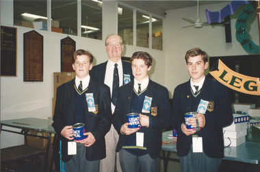
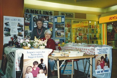 Melbourne Legacy
Photograph - Photo, Widows function, Badge Week Stall
... in an unknown shopping centre. Boyles Sweets closed down by July 1993... shopping centre. Boyles Sweets closed down by July 1993 so ...Widows are conducting a sale of craft items in a shopping arcade. It is possible the items sold were those made for the annual Art and Craft Exhibitions. The Legacy signs say "Legacy caring for Australia's biggest family". The trading tables are outside a Boyles Sweets shop and a Franklins No Frills supermarket in an unknown shopping centre. Boyles Sweets closed down by July 1993 so it was before then. Names unknown. Photos were in a scrapbook of photos spanning 1983 to 1991.A record of the type of activities Legacy provided as a social outlet for widows and fundraising for Legacy. Colour photo x 4 of a craft stall run by Legacy widows.This paper manufactured by Kodak.widows, fundraising -
 Ringwood and District Historical Society
Newspaper, Scrapbook Clipping, Library Collection, Ringwood, Victoria
... shopping centre.... of Eastland shopping centre. Newspaper Clipping from "The Post", 3 May ...Newspaper Clipping from "The Post", 3 May 1993, Page 4, "Manager sought for Civic Centre make-overThe possibilty Ringwood Civic Centre might be relocated in future was considered before council decided to advertise for a manager for the proposed $1.03 million refurbishment project later in 1993, Cr Max Williams told residents at the last council meeting. Several residents believe council might decide to incorporate a new Civic Centre in plans for a retail and commercial development it is currently considering building in front of Eastland shopping centre. -
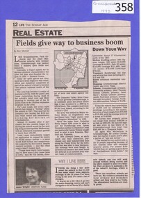 Greensborough Historical Society
Newspaper clipping, Fields give way to business boom, 1993_
... of two suburban Melbourne shopping centres, at Dandenong... of Greensborough shopping area. In Canberra Times Wednesday 17 November ...Tells some of the story of the settlement of Greensborough and Lend Leases' gradual take over of Greensborough shopping area. In Canberra Times Wednesday 17 November 1993, page 27: Melbourne: Lend Lease Corp Ltd is to undertake a $600 million redevelopment of two suburban Melbourne shopping centres, at Dandenong and Greensborough; to be built in conjunction with Australia's largest retailer; Coles Myer Ltd. The project will create about 2000 jobs; 1000 during construction and 1000 in long-term retail.Has some history of Greensborough and records the average land prices in 1993. A black and white Sunday Age newspaper story. Includes map and photograph of resident.greensborough, lend lease, 1993, land prices -
 Melbourne Tram Museum
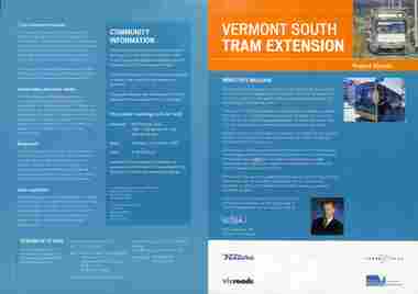
Pamphlet, Department of Infrastructure (DOI), "Vermont South Tram Extension" - set of 2, Oct. 2003
... shopping centre. Includes a message from the Minister... shopping centre. Includes a message from the Minister for Transport ...Pamphlet titled "Vermont South Tram Extension", about the proposal to extend route 75 from Blackburn Road to Vermont South shopping centre. Includes a message from the Minister for Transport Peter Batchelor, with notes on the project, background work, project timing, traffic management, and a forthcoming project public meeting to be held on 15/10/2003. Published by DOI. Second pamphlet gives details of project timing. Both have logos of Ventura, Yarra Trams, vicroads and DOI.Yields information about the DOI project to extend route 75 to Vermont South.Pamphlet - four page A4 full colour and four fold DL.trams, tramways, planning, doi, route 75, vermont south, new tramways, projects -
 Whitehorse Historical Society Inc.
Photograph, View from Mitcham Pedestrian Bridge, 1/07/2000 12:00:00 AM
... Road, Mitcham, looking north-east towards the Mitcham Shopping..., Mitcham, looking north-east towards the Mitcham Shopping Centre ...Coloured photo from the pedestrian overpass on Whitehorse Road, Mitcham, looking north-east towards the Mitcham Shopping Centre.- North - side. House with Spanish taste belonged to Mr. Peake of Peake and Cox, the timber yard directly across Whitehorse Road from this house which became the new site of St.John's Roman Catholic Primary School. This house was on the corner of Whitehorse Road and Albert Street. Upon the sale of the timber yard and mill the catholic church the house was also sold to the church and was occupied as a residence for the school's teaching Sister's. (House since demolished)whitehorse road, mitcham, pedestrian overpass -
 Whitehorse Historical Society Inc.
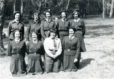
Photograph, Nunawading Brownie Guiders in Mitcham Shopping Centre, Late 1950s - Early 1960s
... at a parade in Mitcham Shopping Centre. Photo shows the Mitcham shops... Shopping Centre. Photo shows the Mitcham shops on the north side ...Black and white photo of Nunawading Brownie Guiders at a parade in Mitcham Shopping Centre. Photo shows the Mitcham shops on the north side of Whitehorse Road, west of Mitcham Road.The traders shown in the photo, left to right, Claude Richards-Draper; D.G.Williamson - Fruiterer; Bob Dorien - Chemist in same building as Williamson; Hay and Corn Store - ???; and Norman & Sons-Grocer.Across Mitcham Road is Barrie George - Milk Bar; Fish Shop- ??? and Ken Herbert - Grocer; the Mitcham Memorial Hall is on the east side.It is estimated that the photo was taken in the late 1950s or early 1960s.richards, claude, dorien, bob, williamson, d.g., norman & sons, george, barrie, herbert, ken, fish shops, mitcham memorial hall, gardiner, shirley, floyd, peg, quick, judith, elsworth, jean, lynette, brown, evelynne, hogben, pam, sue, yarrow, erica -
 Eltham District Historical Society Inc
Photograph - Photograph postcard, A peep at the picnickers, Eltham, c.1904
... . Haley’s Paddock (now occupied by Eltham shopping centre.... Haley’s Paddock (now occupied by Eltham shopping centre ...Postcards scanned from the collection of Michael Aitken on loan to EDHS, 13 Feb 2018 Reproduced ‘Pioneers & Painters’ pp 52-53. Picnickers enjoying a Sunday outing in the fields opposite Eltham Railway Station. Looking north towards Research along Main Road near the intersection with Dudley Street. Luther Hayley’s Bakery and General Store on left promoting refreshments and summer drinks. With the opening of the railway to Eltham in 1902, Melbourne residents would regularly enjoy a Sunday excursion journey on the train to Eltham for a day’s outing to the countryside. Possibly the annual State schools picnic held by the Board of Advice at Haley's Paddock near Eltham railway station on 11 March, 1904. Haley’s Paddock (now occupied by Eltham shopping centre) was capable of accommodating 10,000 people, with ample shade and hilly surroundings, an ideal place for any gathering. The main foreground is the site of the present day Eltham Village and Coles Shopping Centre. 1904 'STATE SCHOOLS' PICNIC.', Record (Emerald Hill, Vic. : 1881 - 1954), 19 March, p. 3. http://nla.gov.au/nla.news-article165173087Digital file only Postcards scanned from the collection of Michael Aitken on loan to EDHS, 13 Feb 2018michael aitken collection, postcards, eltham, main road, bakery, eltham village reserve, general store, haley's paddock, luther haley, luther haley general store, picnic, pioneers and painters, railway store, shire of eltham pioneers photograph collection, summer drinks -
Glen Eira Historical Society
Article - BALACLAVA ROAD, 230-232, CAULFIELD NORTH
... it is not specified as to whether it is a shopping centre, warehouse... is commercial, though it is not specified as to whether it is a shopping ...This file contains one item: 1/A cutting of an article from the commercial real estate subsection of The Age, dated 13/11/2010, describing a property located at 230-232 Balaclava Road, Balaclava Junction, Caulfield North. The property is commercial, though it is not specified as to whether it is a shopping centre, warehouse, or whatever else. Listed are the building’s size, condition, current rental revenue, parking facilities, nearby amenities, auction date and expected selling price range, as provided by Gross Waddell Real Estate Agency.commercial establishments, balaclava road, hawthorn north, caulfield north, rents and renting, car parks, gross waddell, real estate agencies, gross michael -
 Sunbury Family History and Heritage Society Inc.
Photograph, Clarke Oval
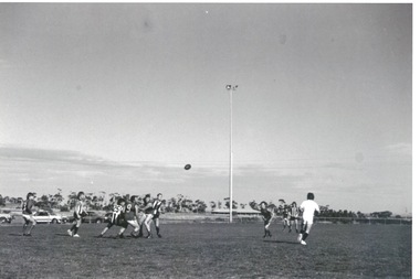
... Sunbury Shopping Centre was where football was played until Clark... Shopping Centre was where football was played until Clark Oval ...The Sunbury Football Club, known as 'The Swifts' was formed in 1897 and the early matches were probably played on Munro's which was a stretch of land bounded by Evans, Barkly, O'Shanassy and Shields Streets. Later land adjacent to the railway line, now Sunbury Shopping Centre was where football was played until Clark Oval was opened in 1953. Since then it has been the town's main sporting venue and the site for the annual show and other events. In this photograph the football match is being played on the Clark Oval with the clubrooms visible in the background. The Sunbury Football Club is one of a number of sports clubs established vin Sunbury.A non-digital black and white photograph of a football match being played on an oval. The clubrooms are visible in the distance.sunbury football club, clark oval, "the swifts' -
City of Kingston
Photograph - Black and white, 27 February 1964
... of the future Southland shopping centre has not yet been demolished... of the future Southland shopping centre has not yet been demolished ...Cheltenham is a suburb in the City of Kingston that was originally established as a rural market gardening community. The area is bordered by Highett. The previous market gardens, farms and paddocks have gradually been sub-divided into housing and industrial estates. The Methodist Children's Home Methodist Homes for Children and St John of God Training Centre on the site of the future Southland shopping centre has not yet been demolished. The recently built Cheltenham High School is visible and the increased urbansation of the area is evident. Some farmland remains including the Le Page homestead.The developing urban area of Cheltenham within the City of Kingston. This image illustrates the mid-century urban sprawl of of Cheltenham and the subdivision of market gardens within the municipality and the changing demographic of the district as new houses are constructed and infrastructure established.Aerial photograph of the suburbs of Cheltenham and Highett within the City of Kingston. Highett Gas Works (top left); Bernard Street, Cheltenham (top right); Weatherall Road (bottom left): Elliott and Cobham Streets Cheltenham (bottom right).White handwritten: X Vic.1831 White type: MELBOURNE 1963 PROJECT RUN23 [underlined] 27-2-64 LENS 205 152-70 M/M 5.150 [arrow] White handwritten: X 166 cheltenham, highett, urbanisation -
 Surrey Hills Historical Society Collection
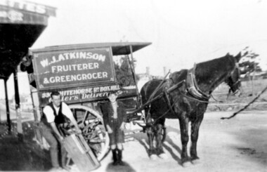
Photograph, Delivery cart outside Mr & Mrs W. J. Atkinsons's greengrocery business near the corner of Elgar and Whitehorse Roads, c1930
... as it approaches the shopping centre and over the back of the horse can... be seen Whitehorse Road as it approaches the shopping centre ...Delivery cart of Mr & Mrs W J Atkinson’s greengrocery business and general store near the corner of Whitehorse and Elgar Roads, c 1930. Emma Uebergang and William James Atkinson married in 1930. They ran a mixed business in Whitehorse Road from 1926-1952. Stock included fruit and vegetables, sweets and some groceries. With Mr Atkinson is Albert Cunnington who in about 1930 helped with deliveries. To the left can be seen Whitehorse Road as it approaches the shopping centre and over the back of the horse can be seen the White Horse Hotel. This was demolished in 1938.A black and white photograph of a horse and delivery cart identified as W. J. Atkinson Fruiterer and Greengrocer, 33? Whitehorse Road Box Hill.land transport, carts and wagons, horse drawn vehicles, fruiterer and greengrocer, whitehorse road, elgar road, mont albert, box hill, mr william james atkinson, mrs emma gertrude atkinson, miss emma gerte uebergang, mr albert cunningham -
 Melbourne Legacy
Photograph, Legacy Appeal 1992, 1992
... Victoria Hospital has been demolished and the new QV shopping... Victoria Hospital has been demolished and the new QV shopping ...A photo of President G. M. Swan with a group of school boys with Appeal tins. Also a police band on Swanston Street and a trading table set up by the Legacy Widows outside Legacy house. The widows clubs ran a craft stall outside Legacy house for many years to help with fundraising during Legacy Week. Also the author Patsy Adam-Smith is in one photo. She went on to be a celebrity of the year for Legacy in 1994. Of note is that the Queen Victoria Hospital has been demolished and the new QV shopping centre has not yet been built.A record of Legacy Week in 1992.Colour photo x 3 of Legacy Appeal in 1992.Printed on the back "707 0131 N N N 1 2" and 708. On Kodak paper. legacy week, badge week, legacy appeal -
 Eltham District Historical Society Inc
Photograph, Looking south along Main Road, Eltham near John Street, c.1970, 1970c
... Opportunity Shop) in centre left. The building on immediate left has... Opportunity Shop) in centre left. The building on immediate left has ...Eltham Uniting Church and former CBA bank (later Opportunity Shop) in centre left. The building on immediate left has since been demolished and is now the site of Goodstart Early Learning Eltham kinder120 format 6x9 clr positivecba bank, john street, main road, pitt street, uniting church