Showing 10762 items
matching sites
-
 Bendigo Historical Society Inc.
Document - GLASGOW AND GOLCONDA CONSOLIDATED GOLD MINE
Information regarding the Glasgow and Golconda Consolidated Gold Mine, Golden Gully. Mine is on the Napoleon Reef, shaft depth of 800 ft. A description of the physical remains is given and the significance of the site is described. It is the only site in Bendigo 'which retains evidence of the tramway between the mine and the battery site'bendigo, mining, glasgow golconda mine site -
 Port Melbourne Historical & Preservation Society
Plan - Market site and Council Depot, City of Port Melbourne, City Engineer, City of Port Melbourne Site plan of Market Properties and Council Depot, 1938 - 1939
City of Port Melbourne Site plan of Market Properties and Council Depot. Site plan also shows the library and old Fire Station. Made approximately 1938 to 1939. Pencil markings show later use of the site when the market property was used as part of the council depot.red pen "686"built environment - civic, built environment - commercial, engineering department - city of port melbourne -
University of Melbourne, Burnley Campus Archives
Plan, Circus Site, c. 1990
(1) Copy of Plan: City of Richmond City Engineers Department Circus Site: includes Descriptions of Site Preparation, Plant List and Plant Order List. (2) On tracing paper: Plant Plan. (3) On tracing paper: "Yarra Vegetation Survey - Site 3," Plant Plan(1) Handwritten on reverse, "Richmond Council - Yarra Blvd to Bridge Road."circus, survey, richmond, vegetation survey, colin mock, yarra river -
 City of Moorabbin Historical Society (Operating the Box Cottage Museum)
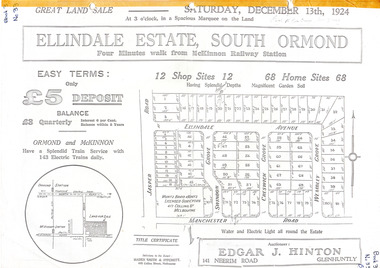
Flyer - Ellindale Estate, South Ormond, 1924
The train line from the city to Frankston was electrified in 1922 which intensified the sale in the municipality of Moorabbin, particularly land which was in the vicinity of the railway stations.Example of the progress of the Municipality of MoorabbinAdvertising flyer for auction of real estate sales - plan of building blocks for salePhotocopy of advertising brochure and two photocopies of advertisements for the auction of Ellindale Estate, South Ormond on 13 December 1924 consisting of 12 shop sites and 68 home sitesjasper road, swindon grove, creswick grove, wembley grove, ellindale ave, ormond, mckinnon, real estate, auction -
![Photograph, Untitled [Aerial view of construction of CSR Softwood Dartmoor Mill], n.d](/media/collectors/4f729f5597f83e03086015b1/items/655a82f77f3f3810362ecfda/item-media/655a82fa7f3f3810362ef5bf/item-fit-380x285.jpg) Glenelg Shire Council Cultural Collection
Glenelg Shire Council Cultural CollectionPhotograph, Untitled [Aerial view of construction of CSR Softwood Dartmoor Mill], n.d
Port of Portland Authority archives.Front: (no inscriptions) Back: (no inscriptions)port of portland -
Bendigo Historical Society Inc.
Document - GREAT EXTENDED HUSTLERS: MAPS OF HUSTLERS MINE SITE
Three maps, copies. Great Extended Hustlers mine site. Hustlers Royal Reserve No. 2 Mine. Streets around Great Extended Hustlers mine site and reserve.bendigo, mining, great extended hustlers -
Whitehorse Historical Society Inc.
Newspaper, Fight Drags On Over Ex-School Site Plans, 28/07/1992 12:00:00 AM
Local Residents make submissions to the Community Services & Planning Committee of Nunawading CouncilLocal Residents make submissions to the Community Services & Planning Committee of Nunawading Council over siting of 22% Open Public Space on former Middlefield Primary School site.Local Residents make submissions to the Community Services & Planning Committee of Nunawading Council middlefield primary school, city of nunawading, primary schools -
University of Melbourne, Burnley Campus Archives
Work on paper (item) - Student Work, Cassie Deleeuw, Home & Pool Landscape Design, 31st October, 2016
Created as an assignment for HORT90035, 'Landscape Construction and Graphics,' a subject at Burnley Horticultural College coordinated by Andrew Laidlaw. assignment, landscaping, burnley horticultural college, 'landscape construction and graphics', hort90035 -
 University of Melbourne, Burnley Campus Archives
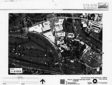
Photograph - Black and white print, Billard Leece R. Corporation, Proposed changes to Burnley Campus site, 2003
Laminated photograph of Burnley site and surroundings. Buildings 1-9 (on area sold off) outlined. Vehicular Site Access Routes marked. By Billard Leece Partnership. R. Corporation No TP 007 REV C August 2003. Typed paper attachment describes proposed development of site.areas sold off, burnley campus, adjustments to site -
 Ringwood and District Historical Society
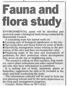
Newspaper, Scrapbook Clipping, Library Collection, Ringwood, Victoria, `
``Newspaper clipping from "The Mail", 12-12-95, P 13. Fauna and flora study Environmental assets will be identified and protected under a biological study being conducted by Maroondah Council. A consulting team has started work on: locating sites of biological significence in the city, surveying flora and fauna, identifying management issues relating to the sites surveyed, producing maps of the sites, and so on. ` -
Queenscliffe Maritime Museum
Geological specimen - Copper ore
The Empress of the Sea was a magnificent three masted, square rigged, wooden sailing clipper ship built in Boston, USA. The Empress of the Sea is historically and archaeologically significant as it was one of Donald Mackay's famous wooden clipper ships, i.e. representative of a particular design or type. It was also associated with both the Black Ball and White Star Lines of Australian Packets, which carried thousands of immigrants from Britain to Australia. The Empress of the Sea caught fire at Queenscliff at 4 am on 19 December 1861. When the officer of the watch attempted to extinguish the fire they found fire pump handles missing and buckets ineffective. Fire became out of control and the ship was sailed from anchorage and ran ashore at Point Nepean. Ship rolled over onto starboard side by force of the tide and the shifting ballast. The port side was burnt to the copper. The Empress of the Sea lies in 5 metres (16 feet) to 7 metres (23 feet) of water, 700 metres (2,297 feet) offshore from Nepean Bay, Port Phillip. The site covers an area 150 metres (492 feet) long and 50 metres (164 feet) wide. The bow lies towards the south-west. Piece of copper ore, possibly part of ships cargo, recovered from the site of the Empress of the Sea shipwrecked in Nepean Bay 1861shipwrecks, nepean bay, empress of the sea -
 Whitehorse Historical Society Inc.
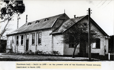
Photograph - Black and white photograph, Blackburn Hall Blackburn
Used by Robin Da Costa in 'Blackburn: a picturesque history' Blackburn Hall, built 1888 on present site of Blackburn Branch Library, demolished March 1965. Photo of an Arbor Day . gathering of local children outside the hall.|See page 85 of Da Costa book. Was also known as the "bug house"" when it was a picture theatre.Black & white photo of Blackburn Hall, built 1888 on present site of Blackburn Branch Library, demolished March 1965. Photo of an Arbor Day gathering of local children outside the hall..|See page 85 of Da Costa book.blackburn hall, blackburn branch library, blackburn -
 Bialik College
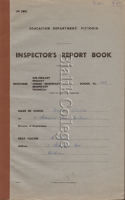
Booklet (item) - Inspector's Report Book, 1967-1970, 1967-1970
... sites ...Inspector's Report Book, 1967-1970. Please contact [email protected] to request access to this record.1960s, 1970s, sites, staff, students, shakespeare grove -
Federation University Historical Collection
Plans, Plans of the Wimmera College of TAFE, 1983, 18/05/1983
The plans were prepared by the Public Works Department VictoriaBook of plans relating to the Wimmera College of TAFE. The book includes developed sketch plans, site plans and landscape plans for the Horsham Technical School site and Langerenong Agricultural Collegewimmera, horsham, wimmera college of tafe, horsham technical school, longerenong, longerenong agricultural college, p. martin, j.t. green -
 Whitehorse Historical Society Inc.
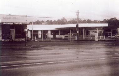
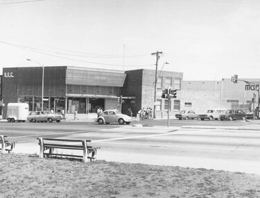
Photograph, Site of new Nunawading ALDI Store, 1/06/2009
Black & white photograph of the site of the proposed new Nunawading ALDI store. The site was the former Caltex Service Station in Springvale Road, Nunawading on the east side and south of the railway line.springvale road nunawading, aldi, caltex service station -
 Bendigo Historical Society Inc.
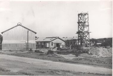
Photograph - Nell Gwynne Mine Site, 1934
Nell Gwynne (B.M.L.) Mine Manager's Report 12th January 1935: Main Shaft - advanced 35 ft to 147 ft below collar and timbered to 131 ft. Progress through W. dipping bed with quartz spurs between 120 and 125 ft. Erection of 1000 cfm compressor unit nearing completion. Sinking winch foundations being placed. (Sun News Pictorial, 12th January 1935) Significant to mining history of Bendigo.Black and white photograph of Nell Gwynne mine site. Image shows three sheds on mine site, metal headframe with four levels constructed in front of sheds and over the shaft. Written in pencil on back of photograph in black pen: 'Nell Gwynne '5/2/35'nell gwynne gold mine, shaft, mining, gold mining -
 Orbost & District Historical Society
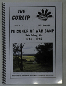
book, The Curlip No : 5, August 2007
This book was compiled after an Orbost Historical Society bus trip to the site of the Prisoner of War Camp at Bete Bolong.This is a locally produced history book which is a useful reference for research into the history of Orbost.A 26 pp spiral bound book with a pale grey cover titled THE CURLIP NO 5, PRISONER OF WAR CAMP, Bete Bolong, Vic. 1943-1946. On the front cover in the top right hand corner is black sketch of a large paddle wheel with the P.S. Curlip in front of it. There is a coloured photograph of the view from the site of the P.O.W. Camp at the intersection of Bete Bolong and Buchan Roads.orbost-history bete-bolong ww11 prisoner-of-war-camp italian-prisoners -
Whitehorse Historical Society Inc.
Pamphlet, Maroondah Highway, Nunawading, 1/10/1999 12:00:00 AM
Auction brochure for 360 Maroondah Highway, Nunawading [Whitehorse Road].Auction brochure for 360 Maroondah Highway, Nunawading [Whitehorse Road]. 3 lots for auction, 27 October 1999. Agent; Collier. Site of the former Nunawading Council Chambers. Includes aerial photo of Nunawading including Whitehorse Rd / Springvale Rd corner and Nunawading Railway Station area.Auction brochure for 360 Maroondah Highway, Nunawading [Whitehorse Road]. whitehorse road, nunawading, no 360, city of nunawading. council chambers, municipal chambers, springvale road, nunawading, nunawading railway station -
 Ringwood and District Historical Society
Photograph, Ringwood cool store demolition site, 1962
Black and white photograph (1 large, 2 small copies)Typed below large photograph: "Overlooking the cool store site, 1962". Written on back of small photograph: "Cool store site cleared. Taken from top of Town Hall." -
 Ringwood and District Historical Society
Photograph, Ringwood Clocktower re-opening ceremony, Cnr Maroondah Hwy and Wantirna Road, Ringwood - December 1967
Black and white photographTyped below photograph: "Re-dedication of Clocktower Memorial when placed in present site (site previously coolstore)." Plaque was unveiled by local resident Major-General L.E. Beavis. -
 Ringwood and District Historical Society
Photograph, Maroondah Highway East, Ringwood- 1969. Looking east from Warrandyte Road railway bridge
Black and white photographWritten on back of photograph: "May 1969, Site of first clock tower." -
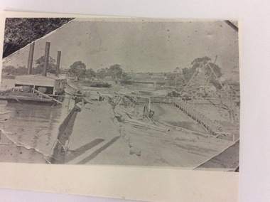 Port of Echuca
A rectangular copy of a black and white photograph, 24/09/1984
This photograph shows how locks were constructed in the early 20th Century. There is floating steam equipment in the left of the photograph. This photograph is significant because it shows equipment used to construct Locks along the Murray in the early days of the 20th Century. It shows the strategy and the lay out do constructing a Lock.A photo copy of a black and white photograph, which looks like it was a photograph taken of a photo which was still in someone's photo album. The photograph shows Lock construction. Locality is unknown.Written in lead pencil on the back are the words; Constructing Lock. Unknown site.irrigation industry, murray river, lock construction., the price family collection -
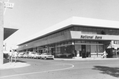 Ringwood and District Historical Society
Photograph, National Bank Building, Melbourne Street, Ringwood 1973
Black and white photograph of National Bank building on corner Melbourne St and Civic Pl Ringwood.On Reverse: "3.4.73 On Site of Old Town Hall" 3rd April 1973 -
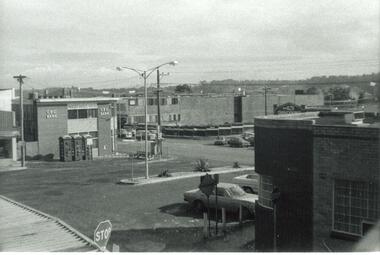 Ringwood and District Historical Society
Photograph, Town hall site after demolition, from railway bridge. Ringwood. ca 1971-73
Undated, but after town hall demolition (1970) and others in this SS358 series are 1971-73Written on back of photograph, "Town hall site from railway bridge." -
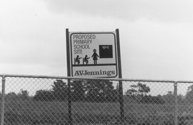 Ringwood and District Historical Society
Photograph, Proposed primary school site. Ringwood, 1982
Catalogue card reads, "Ringwood, 1982. Proposed primary school site". -
 Ringwood and District Historical Society
Photograph, State Electricity Commission building, cnr Maroondah Hwy and Ringwood Street, Ringwood - 1973
Black and white photographWritten on rear of backing sheet, "SEC on site of Ringwood Market. 1973." -
 Ringwood and District Historical Society
Photograph, Site of William's Orchard, Mullum Rd. 1964
Written on backing sheet, "Site of William's Orchard, Mullum Rd. 1964". -
 City of Moorabbin Historical Society (Operating the Box Cottage Museum)
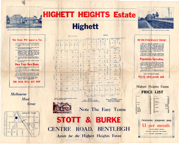
Flyer - Highett Heights Estate, Highett
Land sales in the Municipality of Moorabbin increased when the train line from the City to Frankston was electrified.Example of the progress of the Municipality of MoorabbinAdvertising flyer for auction of real estate sales - plan of building blocks for saleHighett Heights Estate, Highett - Stott & Bourke 58 home siteswickham road, hillcrest avenue, grandview road (now seaton road), maroona road, spring road, real estate, highett, moorabbin -
 Linton and District Historical Society Inc
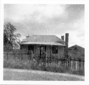
Photograph, Ching brothers' home, formerly Di Piazza's
House at 7 Clyde Street, Linton, formerly Di Piazza's, last lived in by bachelor brothers Bill and Les Ching, 1980s-1990s.Black and white photograph of house with shed at side and front fence."House on site of Di Piazza's Clyde St, donor Shane Grigg".ching family, di piazza, buildings, houses -
![Photograph - Construction of the F19 [Eastern Freeway], Ron Setford, October 1973](/media/collectors/550653872162f11fb04854aa/items/6808c444025de50d1e732a78/item-media/6808c45f025de50d1e732e81/item-fit-380x285.jpg) Kew Historical Society Inc
Kew Historical Society IncPhotograph - Construction of the F19 [Eastern Freeway], Ron Setford, October 1973
Ron Setford and his wife Grace Setford lived in Tanner Avenue, East Kew, from c.1946 to c.1995. A keen photographer, he recorded the changing face of Kew over a 20 year period. Apart from 30 photographs of built structures and places in Kew dating from 1960 and 1961, 145 of his 35mm colour slides chronicle the development of the F19 (later renamed Eastern) Freeway through the Yarra Valley in Kew over a five year period from c.1972 to c.1977. This important collection was donated to the Society by his granddaughter in 2025.This collection of 175 35mm slides is of local and statewide significance, owing to its subject matter, particularly the major development of road transport infrastructure during the 1970s with the construction of the Eastern Freeway. The photographer also took care to annotate and date most of his slides which enable the researcher to pinpoint temporal and spatial locations."Eastern Freeway / Site of F6 O/pass & Chandler H/Way"ron setford, eastern freeway, f19 freeway