Showing 285797 items matching "streets,roads,melbourne,map,melway"
-
 Whitehorse Historical Society Inc.
Article, Another 1.5 million pounds for roads, 1964
... Another 1.5 million pounds for roads ...City of Nunawading's roadmaking program,City of Nunawading's roadmaking program, including lists of streets affected. City of Nunawading's roadmaking program,city of nunawading, road construction and maintenance -
Port Melbourne Historical & Preservation Society
Document, Melbourne Water, Community Bulletin port Melbourne Pump Station Essential Works, Feb 2020 - Apr 2021
Built c.1897, the pumps drain the larger Port Melbourne area to Port Phillip Bay. It was identified that the pumps were at the end of their serviceable life & would need to be renewed.Five Community Bulletins outlining the work to be done on the Port Melbourne Pumping Staion.pumping station, melbourne water -
 Melbourne Tram Museum
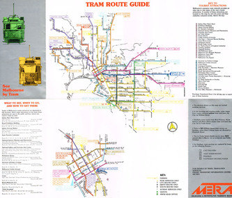
Pamphlet, Melbourne & Metropolitan Tramways Board (MMTB), "See Melbourne by Tram", early 1980's
Fold out pamphlet - 10 sections, titled ""See Melbourne by Tram" providing a detailed tram map of Melbourne, key tourist locations marked on map. Notes that Travelcard Zone 1 can be purchased for all locations. Published by the MMTB early 1980's. Trading name used on pamphlet is "METRA". On inside has sketches and advertisements for some tourist locations and restaurants. Notes which routes were replaced by buses on Sundays. Second copy added 13/1/2017 from Donation of John Prideaux.trams, tramways, map, mmtb, metra -
 Kew Historical Society Inc
Plan, Melbourne & Metropolitan Board of Works : Borough of Kew : Detail Plan No.1582, 1904
The Melbourne and Metropolitan Board of Works (MMBW) plans were produced from the 1890s to the 1950s. They were crucial to the design and development of Melbourne's sewerage and drainage system. The plans, at a scale of 40 feet to 1 inch (1:480), provide a detailed historical record of Melbourne streetscapes and environmental features. Each plan covers one or two street blocks (roughly six streets), showing details of buildings, including garden layouts and ownership boundaries, and features such as laneways, drains, bridges, parks, municipal boundaries and other prominent landmarks as they existed at the time each plan was produced. (Source: State Library of Victoria)This plan forms part of a large group of MMBW plans and maps that was donated to the Society by the Mr Poulter, City Engineer of the City of Kew in 1989. Within this collection, thirty-five hand-coloured plans, backed with linen, are of statewide significance as they include annotations that provide details of construction materials used in buildings in the first decade of the 20th century as well as additional information about land ownership and usage. The copies in the Public Record Office Victoria and the State Library of Victoria are monochrome versions which do not denote building materials so that the maps in this collection are invaluable and unique tools for researchers and heritage consultants. A number of the plans are not held in the collection of the State Library of Victoria so they have the additional attribute of rarity.Original survey plan, issued by the MMBW to a contractor with responsibility for constructing sewers in the area identified on the plan within the Borough of Kew. The plan was at some stage hand-coloured, possibly by the contractor, but more likely by officers working in the Engineering Department of the Borough and later Town, then City of Kew. The hand-coloured sections of buildings on the plan were used to denote masonry or brick constructions (pink), weatherboard constructions (yellow), and public buildings (grey). Public buildings, coloured grey on the Plan 1582 include the police station and post office, churches and schools. The earliest church school, Common School No.356 was located at the rear of the Congregational Church in Peel Street. It was constructed in 1859. The first buildings of Kew Primary School No.1075 on the other side of Peel Street were constructed in 1871. The school in 1903 only occupied a small fraction of its current site. In 1903, where the rear playground is now located, were two weatherboard and one brick villa. Trinity Grammar School was founded in 1902 and opened in the Parish Hall at the rear of Holy Trinity Anglican Church. It was not to move to its current site until 1906. The outline of the building housing the Kew Fire Brigade in the centre of the north side of Walton Street is shown but not named on the plan. Further down Pakington Street stood the two-storey Italianate mansion ‘Overton’. The home of Stanford Chapman, it was to be featured in the Imperial Institute series of bromide photographs of Victoria, Vol. 1: Homes and scenery. It was later to become a boarding house before it was later demolished.melbourne and metropolitan board of works, detail plans, maps - borough of kew, mmbw 1582, cartography -
 The Beechworth Burke Museum Research Collection
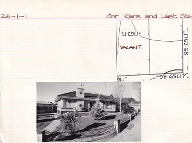
Card (Series) - Index Card, George Tibbits, Cnr Kars & Last Streets, Beechworth, 1976
... Cnr Kars & Last Streets, Beechworth ...George Tibbits, University of Melbourne. Faculty of Architecture, Building and Town & Regional PlanningIndex system that support the research for Beechworth : historical reconstruction / [by] George Tibbits ... [et al]Arranged by street names of BeechworthEach index card includes: street name and number of property, image of property, allotment and section number, property owners and dates of ownership, description of the property according to rate records, property floor plan with dimensions.beechworth, george tibbitsbeechworth, george tibbits -
Port Melbourne Historical & Preservation Society
Document - Electoral Roll, City of Port Melbourne, City of Port Melbourne, Voters Roll, City of Port Melbourne - Boundary Ward, Jul 1990
Prepared by the Town Clerk's office. Voters roll, City of Port Melbourne 1990: List in alphabetical order of residents in Boundary Ward. Signature of A.D. Graham, Municipal Clerk, is on back pagelocal government - city of port melbourne, town clerks, david graham -
Port Melbourne Historical & Preservation Society
Book, Town of Port Melbourne, Town of Port Melbourne, Rates Cash Book, 1900
Rates Cash Book 1900-1903 Town of Port Melbourne. Dark brown cover with tan leather spine and corners, red with gold lettering, labellocal government - town of port melbourne -
 Clunes Museum
Photograph, S.FISHER JOHNSON, CNR. OF STURT & CAMP STREETS,BALLARAT
... S.FISHER JOHNSON, CNR. OF STURT & CAMP STREETS,BALLARAT. ...SMALL OVAL BLACK AND WHITE PHOTOGRAPH OF FRANCES FORD - SQUARE DARK GREY SURROUND. LEFT ARM LEANING ON PEDESTAL- WIDE BLACK COLLAR WITH WHITE TRIMMING.RICHARDS AND COlocal history, photography, photographs, early citizens, richard ford -
Federation University Historical Collection
Book, The University of Melbourne, Annual Examination Papers, 1893, 1894
Annual examination papers for Degrees of B.A., MUS.BAC., LL.B., and M.B. and for the Certificate of Engineer in October 1893 prepared by The University of Melbourne.Brown buff paperback book, illustrations, 435 pagesuniversity of melbourne, examination papers, ballarat school of mines library, engineering studies -
Port Melbourne Historical & Preservation Society
Map, City of Port Melbourne. Parishes of melbourne South. Doutta Galla, c. 1930
City of Port Melbourne. Parishes of Melbourne South. Doutta Galla Copy of map circa 1930, showing Port Melbourne, Station and Town piers. Map is black on white paper with numbered red dots on most residential blocks. 1876 written in ballpoint on bottom - possibly date of first edition, before later additions.built environment, engineering department - city of port melbourne -
Ringwood and District Historical Society
Pamphlet, Vic Roads, Eastern Freeway: Doncaster Road to Springvale Road extension, and Scoresby Transport Corridor. Pamphlets. 1993-6, 1993-1994 & 1996
... Vic Roads ...Eastern Freeway: Doncaster Road to Springvale Road extension - 2 pamphlets;; Scoresby Transport Corridor: 1 pamphlet. -
 Surrey Hills Historical Society Collection
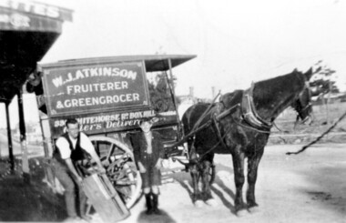
Photograph, Delivery cart outside Mr & Mrs W. J. Atkinsons's greengrocery business near the corner of Elgar and Whitehorse Roads, c1930
... greengrocery business near the corner of Elgar and Whitehorse Roads ...Delivery cart of Mr & Mrs W J Atkinson’s greengrocery business and general store near the corner of Whitehorse and Elgar Roads, c 1930. Emma Uebergang and William James Atkinson married in 1930. They ran a mixed business in Whitehorse Road from 1926-1952. Stock included fruit and vegetables, sweets and some groceries. With Mr Atkinson is Albert Cunnington who in about 1930 helped with deliveries. To the left can be seen Whitehorse Road as it approaches the shopping centre and over the back of the horse can be seen the White Horse Hotel. This was demolished in 1938.A black and white photograph of a horse and delivery cart identified as W. J. Atkinson Fruiterer and Greengrocer, 33? Whitehorse Road Box Hill.land transport, carts and wagons, horse drawn vehicles, fruiterer and greengrocer, whitehorse road, elgar road, mont albert, box hill, mr william james atkinson, mrs emma gertrude atkinson, miss emma gerte uebergang, mr albert cunningham -
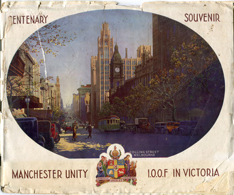 City of Moorabbin Historical Society (Operating the Box Cottage Museum)
Booklet - Centenary Souvenir - Manchester Unity I.O.O.F in Victoria, IOOF Melbourne, 1934
A booklet issued by The Grand Master and Board of Directors M.U.I.O.O.F. in Victoria and compiled by W .H. Best, Grand Secretary printed in the year the City Of Melbourne began the celebration of its Centenary (1934). The booklet is about the history of Manchester Unity I.O.O.F. and the building of their Gothic building, known as the Manchester Unity Building on the corner of Collins and Swanston Streets, Melbourne. The booklet also contains many advertisements from firms who supported the compiling and publishing of the document.Many of the families living in the City of Moorabbin were members of Manchester Unity I.O.O.F. Victoria.A booklet with 40 pages printed in black and white, contents include story of the building of the Manchester Unity Building on the corner of Collins Street and Swanston Street. Advertisements of various businesses in Melbourne. Coloured Cover with a view of Collins Street.CENTENARY SOUVENIR/ PHOTO of Collins St Melbourne, / MANCHESTER UNITY / Crest of Arms/ I.O.O.F IN VICTORIAmanchester unity i.o.o.f. victoria, manchester unity building, collins street, swanston street -
 Kew Historical Society Inc
Plan, Melbourne & Metropolitan Board of Works : Borough of Kew : Detail Plan No.1563, 1905
The Melbourne and Metropolitan Board of Works (MMBW) plans were produced from the 1890s to the 1950s. They were crucial to the design and development of Melbourne's sewerage and drainage system. The plans, at a scale of 40 feet to 1 inch (1:480), provide a detailed historical record of Melbourne streetscapes and environmental features. Each plan covers one or two street blocks (roughly six streets), showing details of buildings, including garden layouts and ownership boundaries, and features such as laneways, drains, bridges, parks, municipal boundaries and other prominent landmarks as they existed at the time each plan was produced. (Source: State Library of Victoria)This plan forms part of a large group of MMBW plans and maps that was donated to the Society by the Mr Poulter, City Engineer of the City of Kew in 1989. Within this collection, thirty-five hand-coloured plans, backed with linen, are of statewide significance as they include annotations that provide details of construction materials used in buildings in the first decade of the 20th century as well as additional information about land ownership and usage. The copies in the Public Record Office Victoria and the State Library of Victoria are monochrome versions which do not denote building materials so that the maps in this collection are invaluable and unique tools for researchers and heritage consultants. A number of the plans are not held in the collection of the State Library of Victoria so they have the additional attribute of rarity.Original survey plan, issued by the MMBW to a contractor with responsibility for constructing sewers in the area identified on the plan within the Borough of Kew. The plan was at some stage hand-coloured, possibly by the contractor, but more likely by officers working in the Engineering Department of the Borough and later Town, then City of Kew. The hand-coloured sections of buildings on the plan were used to denote masonry or brick constructions (pink), weatherboard constructions (yellow), and public buildings (grey). This plan covers the area between Barkers Road, Wrixon Street, Sackville Street and Brougham Place, much of it now occupied by Carey Baptist Grammar and Preshil schools. This was an area of large and prestigious homes in 1903, some with formally laid-out gardens, such as ‘Tower Hill’ and ‘Opawa’. ‘Kalimna’ was built in 1890-91 for William H. Jarman, an accountant, and ‘Blackhall’ at the same time for W.H. Roberts. Blackhall was to be acquired by the Salvation Army in 1915 and renamed ‘Catherine Booth Girls’ Home’. The Home accommodated girls, aged between 4 and 16. Kalimna and Blackhall are of significance as typical and intact late Victorian mansions and as such are two key Victorian buildings to have been built in Kew. Both Blackhall and Kalimna are now part of Preshil. ‘Fairview’ was for a long time occupied by the Sisters of St. Joseph of Cluny as a care home for the elderly, but it is now part of Carey Grammar School, as are the grounds of ‘Wagga Merne’, ‘Weemutta’, ‘Blakely’, ‘Daheim’ and ‘Mildura’ (later ‘Urangeline’), the last being particularly impressive in 1903, with a tennis court, conservatory, outhouses, and two bathrooms!melbourne and metropolitan board of works, detail plans, mmbw 1563, cartography -
Port Melbourne Historical & Preservation Society
Programme, Roland Harvey, 1999 Port Melbourne Festival, Feb 1999
Produced by the Port Melbourne Festival Committee in conjunction with the Bay Street Traders and Circus Oz and distributed throughout the municipality. 1999 was the infamous street festival sponsored in part by the Gateway Project, a group of three developers intending to build tall buildings of up to 22 stories in Bay Street between Graham and Rouse Streets (see p. 11). This so angered the Port Phillip Council that they took the Festival from the Committee and put it out to tender from anyone that would restore its 'community' basis. Port Melbourne Neighbourhood House won the tender for 200 to 2002 (see items 1255)Program for Port Melbourne Festival 1999: A4, 16pp, full colour (two copies)arts and entertainment, celebrations fetes and exhibitions, town planning - proposals shelved, port melbourne festival committee, circus oz -
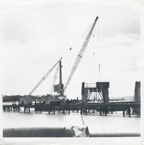 Phillip Island and District Historical Society Inc.
Photographs, Country Roads Board, Phillip Island 2nd Bridge Construction, 1966 - 1969
... Country Roads Board ...13 Black & White photographs from a collection of 70 of the construction of the second bridge for Phillip Island from San Remo to Newhaven by Country Roads Board - contrator John Holland & Co Pty. Ltd. Shire of Bass.13 Black & White photographs of the construction of the second Phillip Island Bridge from San Remo to Newhaven by Country Roads Boards from 1966 to 1969. All photos taken at various times throughout the construction showing the materials, machinery and men involved.351-23: CRB NEG No. 67-1219. 351-24: CRB NEG No. 67-1220. 351-25: CRB NEG No. 67-1291A. 351-26: CRB NEG No. 67-1629B. 351-27: CRB NEG No. 67-1629D. 351-28: CRB NEG No. 67-1629E. 351-29: CRB NEG No. 67-1630A. 351-30: CRB NEG No. 67-1630C. 351-31: CRB NEG No. 67-1630D. 351-32: CRB NEG No. 67-1825A. 351-33: CRB NEG No. 67-1825F. 351-34: CRB NEG No. 67-1826C. 351-35: CRB NEG No. 67-1826D.2nd phillip island bridge construction, phillip island bridge construction, country roads board, shire of bass, john holland & co pty ltd, sasha stark -
 Bacchus Marsh & District Historical Society
Map, Gaynor Street Area Land Sales, Maddingley, 1888
This map was produced for a major sale of land in the Maddingley area of Bacchus Marsh in 1888. The sale was conducted by two firms from Melbourne, Carney and Kelly 12 Swanston Street Melbourne. and 'Richardson, Kerr & Co. 40 Flinders Lane Melbourne. 136 blocks were for sale.A single page paper map showing land allotments for sale in the Maddingley area of Bacchus Marsh. Locations shown include Gaynor Street, Maddingley Road South, Parwan Road, Mitchem Street, Typpynge Street, Finn Street and East Maddingley Road. . The map is pasted into a bound volume containing 76 maps or plans in total. High resolution digital image stored on BMDHS computer network. bacchus marsh victoria maps, maddingley victoria maps, land use, maddingley victoria history, land sales bacchus marsh, land sales maddingley -
Port Melbourne Historical & Preservation Society
Book, Port Melbourne Health Centre nurses, Port Melbourne Health Centre Record Book, 1918 - 1941
This record was kept from July 1918 although Turnbull & U'Ren state that the infant centre opened in October of 1918 at the Town Hall. Port Melbourne Health Centre Record Book, 1918-1941; showing details of diseases, babies, expectant mothers, numbers treated etc. Maroon, bound in maroon tape.health - general health, families, sandridge lagoon, port melbourne health centre, catherine harney woodruff -
Port Melbourne Historical & Preservation Society
Document - Document regarding youth sport and recreation, Port Melbourne Y.M.C.A, Committe meeting of Port Melbourne Youth Centre Aid & Development 6 .10.1969, c1969-73
Several documents relating to the development of Youth centres in Port MelbourneMinutes of committee meeting Port Melbourne Youth Centre Aid and Development Association 6 Oct 1960 fictionSeveral documents relating to the development of Youth centres in Port Melbourne archibald (arch) todd, societies clubs unions and other organisations, port melbourne youth centres aid and development association, morison, mcleod, sedgman, villiers, brooks, armishaw, brockhoff, christie, charleworth, cruikshank, mrs allport, miss spinner, theodore thomas (tom) buckingham -
 National Wool Museum
Map, Map of Western Australia Showing the Principal Sheep and Cattle Stations, 1921
Map showing the principal sheep and cattle stations of Western Australia as of 1921.MAP OF / WESTERN AUSTRALIA / Showing the Principal / SHEEP AND CATTLE STATIONS / 1921 / COMPILED & DRAWN BY HOPE & KLEM / Surveyors & Draughtsmen / 23 Barrack St, Perth, WAsheep stations -
Port Melbourne Historical & Preservation Society
Pamphlet - Facilities, brief history and map, Port of Melbourne, Port of Melbourne, 1980
Eight pamphlets covering the facilities, brief history and map of the Port of Melbourne to 1980. Printed for use as handouts.melbourne harbor trust - port of melbourne authority, transport - shipping -
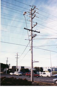 Whitehorse Historical Society Inc.
Photograph, Cnr. Cochrane & Whitehorse Roads, 1/06/1999 12:00:00 AM
... Cnr. Cochrane & Whitehorse Roads ...Coloured photo of Overhead wires corner Whitehorse Road and Cochrane Streets, Mitcham, looking North. (Before installation of underground wires) - See also NP 1907 and NP1908whitehorse road mitcham, cochrane street mitcham, overhead powerlines -
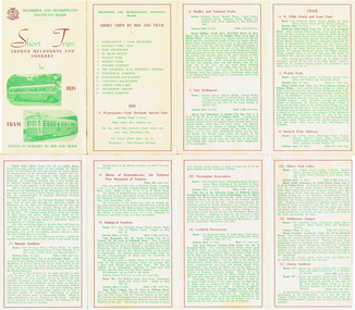 Melbourne Tram Museum
Pamphlet, Melbourne & Metropolitan Tramways Board (MMTB), "Short Trips around Melbourne and Suburbs by Bus and Tram", mid 1960's
Pamphlet titled "Short Trips around Melbourne and Suburbs by Bus and Tram", two colour printed document folded into 8 on buff coloured paper, featuring 14 various trips around Melbourne, with a detailed description of each route, time, fare and notes. On reverse side is a detailed map of the MMTB tram and bus routes - from map date document mid to late 1960's - old route numbers eg 4D and Point Ormond and Footscray have closed. See also Reg Item 1508 for an earlier version.trams, tramways, mmtb, map, tourist trips, fares, routes -
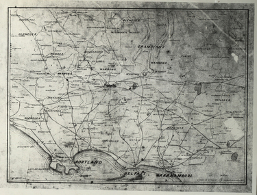 Federation University Historical Collection
Photograph - Black and White, Map of Western Victoria
WGS 84 37" 47' S 142" 08' EPhotograph of a map showing the Grampians, Glenelg, Portland, Belfast (Port Fairy), Warrnambool, roads and land-holders.western victoria, victoria, belfast, port fairy, warrnambool, manifold -
 Whitehorse Historical Society Inc.
Document, Map of Vermont & Mitcham
Copy of map showing land in Mitcham and Vermont areasCopy of map showing land in Mitcham and Vermont areas bounded by Whitehorse , Mitcham, Canterbury and Heatherdale roads.Copy of map showing land in Mitcham and Vermont areasland subdivision, whitehorse road, mitcham, heatherdale road, canterbury road, vermont, mitcham road -
Whitehorse Historical Society Inc.
Map, Nunawading Shire, 1892
Photocopy of an enlargement of map of Shire of Nunawading showing landowners in 1892.Photocopy of an enlargement of map of Shire of Nunawading showing landowners in 1892. Covers Middleborough Road to Ringwood boundary. One map (Blackburn) from north of Whitehorse Road to Highbury Road, 2nd map (Mitcham) Bulleen to south of Canterbury Road; 3rd map Whitehorse Road to Highbury Road.Photocopy of an enlargement of map of Shire of Nunawading showing landowners in 1892. maps, shire of nunawading, blackburn, blackburn south, nunawading, forest hill, vermont, mitcham, vermont south -
 City of Kingston
Pamphlet - Colour, Roy Dunn Pty. Ltd, Subdivisional auction of Highett Station Estate, c.1924
Sales plan for land in the suburb of Highett, bounded by Worthing Road, and the Melbourne to Frankston Electric Railway Line, including LePage Street. The developing urban area of Highett within the City of Kingston. This land sale pamphlet illustrates the subdivision of land within the municipality and the changing demographic of the district as new houses are constructed close to infrastructure.Colour pamphlet advertising a subdivisional auction of the Highett Station Estate. Incorporates a map of the estate bordered by Worthing Road and the Melbourne to Frankston Electric Railway, and including LePage Street. Handwritten in black ink on front cover: Late LePage / Wickham Rdland sales, estate, highett -
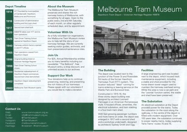 Melbourne Tram Museum
Pamphlet, Melbourne Tram Museum, "Melbourne Tram Museum", Jul. 2017
Colour photocopy - folded to A5 on titled "Melbourne Tram Museum", providing details of the Hawthorn Tram depot. Includes photo of depot on front cover, history of the Building, Operations, Location , Expansion, Decline and Redevelopment. Includes a depot map and a list of the tramcars On the rear is a timeline, details of the Museum. Used for the 2017 Melbourne Open House depot. Prepared by Adam Chandler July 2017.trams, tramways, hawthorn, melbourne tram museum, mtm, depots, pamphlets -
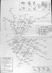 Melbourne Tram Museum
Map, P. Sohns, "Strassenbahn Melbourne Gleisplan", 10-9-1992
Map of Melbourne's tramway system prepared for a German audience - as at 28-5-1992. Shows the track layout, crossovers, depots, route numbers, railway/tramway level crossings, terminus details, road names and a CBD insert. Prepared by P Sohns of Germany - dated 10-9-1992.Yields information Melbourne tramways and routes in 1992.Map - A2 sheet folded to A4.tramways, maps, melbourne, germany -
Whitehorse Historical Society Inc.
Map, City of Nunawading map, 1970s (post 1974)
Catchment area of Blackburn East Primary School.Catchment area of Blackburn East Primary School marked in texta on map of the City of Nunawading. Scale: 1 km:6 kmCatchment area of Blackburn East Primary School. city of nunawading, blackburn east primary school no. 4800