Showing 8519 items
matching water-flow
-
 Eltham District Historical Society Inc
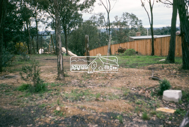
Photograph, Water Main Pipe Track (Madine Way-Eucalyptus Road), Eltham, 3 Sep 1981
Roll of film taken by Eltham Shire Council officers of roads and houses in the Eltham East area, 3 September 1981 prior to construction of new water main; including views of existing damage to footpaths and gutters and general views of Beard Street. These images provide a perspective of housing estate developments and changes in housing styles and road development which began sweeping in from the mid 1970s with increasing urbanisation of what was once more outlying suburbs and regions.35mm colour positive transparency (1 of 28) Mount - Kodak Kodachrome Cardeltham, infrastructure, roads, water main pipe track, madine way, eucalyptus road, tadema park -
 Eltham District Historical Society Inc
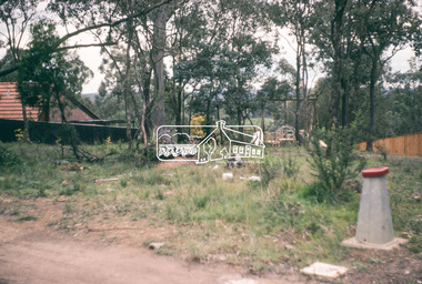
Photograph, Water Main Pipe Track (Madine Way-Eucalyptus Road), Eltham, 3 Sep 1981
Roll of film taken by Eltham Shire Council officers of roads and houses in the Eltham East area, 3 September 1981 prior to construction of new water main; including views of existing damage to footpaths and gutters and general views of Beard Street. These images provide a perspective of housing estate developments and changes in housing styles and road development which began sweeping in from the mid 1970s with increasing urbanisation of what was once more outlying suburbs and regions.35mm colour positive transparency (1 of 28) Mount - Kodak Kodachrome Cardeltham, infrastructure, roads, water main pipe track, madine way, eucalyptus road, tadema park -
 Eltham District Historical Society Inc
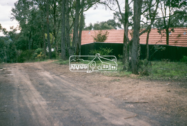
Photograph, Water Main Pipe Track (Madine Way-Eucalyptus Road), Eltham, 3 Sep 1981
Roll of film taken by Eltham Shire Council officers of roads and houses in the Eltham East area, 3 September 1981 prior to construction of new water main; including views of existing damage to footpaths and gutters and general views of Beard Street. These images provide a perspective of housing estate developments and changes in housing styles and road development which began sweeping in from the mid 1970s with increasing urbanisation of what was once more outlying suburbs and regions.35mm colour positive transparency (1 of 28) Mount - Kodak Kodachrome Cardeltham, infrastructure, roads, water main pipe track, madine way, eucalyptus road, tadema park -
 Eltham District Historical Society Inc
Photograph, Water Main Pipe Track (Madine Way-Eucalyptus Road), Eltham, 3 Sep 1981
Roll of film taken by Eltham Shire Council officers of roads and houses in the Eltham East area, 3 September 1981 prior to construction of new water main; including views of existing damage to footpaths and gutters and general views of Beard Street. These images provide a perspective of housing estate developments and changes in housing styles and road development which began sweeping in from the mid 1970s with increasing urbanisation of what was once more outlying suburbs and regions.35mm colour positive transparency (1 of 28) Mount - Kodak Kodachrome Cardeltham, infrastructure, roads, water main pipe track, madine way, eucalyptus road, tadema park -
 Port Melbourne Historical & Preservation Society
Photograph - Under Port Melbourne Railway, Hobsons Bay Main Sewer, "Melbourne water supply", 1890s
Three black and white images taken from: "Melbourne water supply - sewerage schemes" Special edition of the "Building, engineering and mining journal" The operations of the Melbourne and Metropolitan Board of Works. (.03) Plate XXXI. Under Port Melbourne Railway, Hobsons Bay Main Sewer, Section No 3. This view was taken in compressed air, and shows shield doors in background with men placing extra htdraulic power in position. This view also shows the method of constructing with concrete blocks and iron centreing on which to build the upper portion of the sewer.engineering - board of works, built environment - civic, mmbw, sewer, melbourne and metropolitan board of works -
Clunes Museum
Document - ARCHITECTURAL DRAWINGS, CLUNES WATER SUPPLY
CLUNES WATER SUPPLY .1 DRAWING No 21 (CHANGED TO 11). LOWER WEIR. DETAILS OF MASONRY - DESIGN B .2 DRAWING No 5 CONTRACT No 2. LONGITUDINAL SECTION OF CENTRE LINE OF LOWER AQUEDUCT FROM WEIR A TO SERVICE RESERVOIR .3 DESIGNS FOR WEIRS - CROSS SECTION OF THE BED OF THE CREEK SHOWING WEIR STRUCTURE. .4 DRAWING No 11. LONGITUDINAL SECTION - PROPOSED LINE OF PIPES No 1 RESERVOIR. .5 DRAWING No 17 SECTIONS. HANDWRITTEN. .6 DRAWING No 5. PLAN OF LINE OF PIPES No 1 RESERVOIR..2 HANDWRITTEN NOTES ON REAR IN PENCILclunes, water supply, drawings -
 Ringwood and District Historical Society
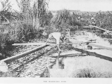
Photograph, The Water-Lily Pond at Hill's Flower Farm, Ringwood, in 1905, 1905
Black and white photograph (2 copies)Typed under photograph: The Water Lily Pond. Mr Hill's flower farm, Mt Dandenong Rd. Later Howship's. In area around Howship Street. Written on back of one image: 'Australasian' 29/3/05. John Hill's flower farm, Mt Dandenong Rd. Later Howship's flower farm subdivided, name retained in street name. Pool was part of Sandy Gully Creek 1905.water lillies, flower farming -
Tatura Irrigation & Wartime Camps Museum
Water Wheel Accuracy Tester, Late 1900s
Used by State Rivers and Water Supply Commission prior to their privatisation about 1990.A clear tube with sand inside - similar to an egg timer. Used to measure the accuracy of water wheels over a half minute or less. Measurements marked on outside and related to one revolution. The blue scales relate to small meter outlets(wheels), yellow scales related to large meter outlets(wheels).Figures of rates relating to measurement of water in one revolution.irrigation, victoria state rivers and water supply commission, water wheel -
 Eltham District Historical Society Inc
Photograph, Remains of the old Water Wheel and Battery, Warrandyte, 1934
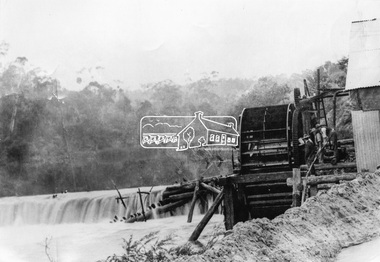
A short distance upstream from the old wooden Warrandyte Bridge, the Yarra river was at one time dammed to give power to a large wooden waterwheel which drove a plant for crushing gold. Up until around 1908 the waters of the Yarra, pent up by a stone weir, forced their way past this old wheel turning it to crush the precious quartz. In 1925 the reamins of the State Battery were removed. The large water wheel (thanks to the forethought of a local resident, Mr. P. Mackie) was left in its position.This photo forms part of a collection of photographs gathered by the Shire of Eltham for their centenary project book,"Pioneers and Painters: 100 years of the Shire of Eltham" by Alan Marshall (1971). The collection of over 500 images is held in partnership between Eltham District Historical Society and Yarra Plenty Regional Library (Eltham Library) and is now formally known as the 'The Shire of Eltham Pioneers Photograph Collection.' It is significant in being the first community sourced collection representing the places and people of the Shire's first one hundred years.Digital image 4 x 5 inch B&W Negshire of eltham pioneers photograph collection, warrandyte, water wheel, caledonia battery, state battery, warrandyte battery -
 Eltham District Historical Society Inc
Photograph, Steam locomotive K-158 filling up with water at the coal hopper, Echuca Railway Station, November 1963, 1963
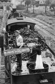
THE ECHUCA COALING STAGE. Locomotives would stop alongside to receive coal dropped into their tenders from small overhead rail mounted tipping trays. Water could be obtained from either the elevated tank at one end or the connected standpipe at the opposite end. Locomotive firebox contents could be dumped into pits between the rails from locomotives once they were carefully positioned above them. Such locomotives then could move onto the Engine Shed area for overnight parking. Firebox fires would be re-lit when the locomotive was next needed in a day or so.Digital TIFF file Scan of 35mm Ilford FP3 black and white negative transparencycoal hopper, echuca railway station, george coop collection, k-158, k-class steam locomotive (vr newport workshops) -
 Eltham District Historical Society Inc
Photograph, Steam locomotive R-727 being filled with water at the coal hopper, Echuca Railway Station, November 1963, 1963
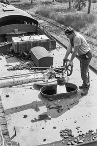
THE ECHUCA COALING STAGE. Locomotives would stop alongside to receive coal dropped into their tenders from small overhead rail mounted tipping trays. Water could be obtained from either the elevated tank at one end or the connected standpipe at the opposite end. Locomotive firebox contents could be dumped into pits between the rails from locomotives once they were carefully positioned above them. Such locomotives then could move onto the Engine Shed area for overnight parking. Firebox fires would be re-lit when the locomotive was next needed in a day or so.Digital TIFF file Scan of 35mm Ilford FP3 black and white negative transparencycoal hopper, echuca, echuca railway station, george coop collection, r-727, r-class steam locomotive -
 Melbourne Legacy
Newspaper - Document, article, New water process will benefit country towns
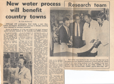
A newspaper article about scientists working on water treatment processes. This document was from a file of information about guest speakers (see also 00812-00822 and 00830-00837). So it is assumed that one of the scientists mentioned was approached to speak at a Legacy function. The caption mentions Dr Don Willis (CSIRO), Dr Hans Battered (ICI), Dr Brian Bolto (CSIRO), and Dr Allan Cope (ICI). Legatees met regularly and had guest speakers to entertain and inform on different subjects at their Tuesday Luncheons. The Programme Committee was responsible for organising the speakers.A record that the speakers at Legacy functions came from many walks of life and the subjects spoken on were varied.Newspaper article with black and white photos of scientists.speakers, legatee event -
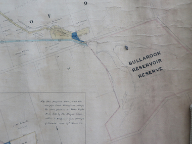 Federation University Historical Collection
Plan, Creswick Water Supply from Bullarook to Creswick, 02/10/1869
Probably gazetted on 12 April 1872 (pg 737)Large horizontal paper plan glued in three sections to a linen backing. Coloured plan shows pipe and rack track from the Bullarook Reservoir to Albert Street, Creswick. Attached with ribbon top left are twelve pages giving bearing and lengths / descriptions of pipe and rack track. Five information boxes drawn along the bottom of plan gives extra information where pipe passes through private properties. Main heading 'Plan of Creswick Water Supply / scale eight chains to an inch / County of Talbot / Parish of Creswick'. Calculations and hand written notes in ink and pencil also on plan. Verso 'Dean Reservoir'. Signed and dated.creswick, water supply, bullurook reservoir, dean, bush inn, hesken, rivers, warner, taylor, gillard, mccormack, mcdonald, brown, naples, humbug hill sluicing co, frank rivers, w.r. taylor, j. and m. mccormack, j. mcdonald, richard brown, c. naples -
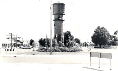 Wodonga & District Historical Society Inc
Photograph - Codling Collection 01 - Water Tower, High Street, 1980
Miss Olive Codling was a Foundation Member and a Life Member of the Wodonga Historical Society. Many of her prize-winning photos are held in the Society Collection. She also held a range of roles and committee positions in a wide range of Wodonga community organisations. These included the Horticultural Society, the Wodonga Arts Council, the Wodonga Camera Club and the Wodonga Lapidary Club. Elaine Mann was married to David Mann, a successful Wodonga businessman and community leader who passed away in Wodonga in June 2012. David was a member of the Mann family who began their business in Wodonga in 1920. Elaine was a teacher in Wodonga for many years.This photo collection is significant as it documents how the businesses and buildings in Wodonga have evolved and contributed to community throughout the 20th century.THE WATER TOWER is a major landmark of High Street, Wodonga. It began operation from January 1924 until it ceased operation in 1959. It stood unused for a decade until the lower section was modified and put to use as “ The Tower’s Cobbler’s Inn” in 1962. In 1972 Wodonga City Council proposed to demolish the Tower. Their suggestion received an unfavorable response from the city’s citizens, so the Tower still stands today. This image shows High Street and Hovell Street looking to the north The Civic Centre Theatre is on the right in Hovell Street. On the left in High Street is Tower Place on left. On the far left Repco which by 1998 became a Chinese restaurant and remains so in 2021.wodonga businesses, high st wodonga, water tower, hovell street wodonga, high street wodonga -
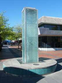 Ringwood and District Historical Society
Photograph, Water feature in Melbourne Street, Ringwood in 2008. It was provided by Maroondah City Council, officially opened on 12 March 1997 to mark the creation of MCC, but rarely having water turned on
Photographic record by Russ Haines, RDHS, in 2008. -
Swan Hill Regional Art Gallery
Painting, NICHOLLS, Ralph, Water holes and swirling water (Murrumburrah Warilla), 1995-96
-
Moorabbin Air Museum
Document (item) - Australian Defence Specification DEF (AUST) 6119A Liners, Box, Water - Vapourproof Of Water Proof 1987 Draft No.1
-
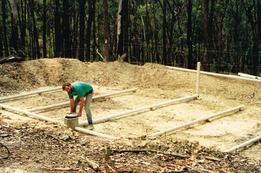 Round the Bend Conservation Co-operative
A member building a transpiration bed to recycle the household water. This is a way of concentrating absorption trenches in a confined area, managing waste water and containing the soil disturbance to the site
-
 Wodonga & District Historical Society Inc
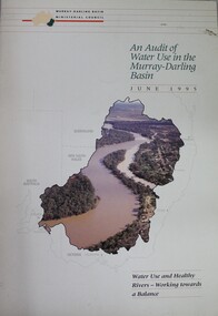
Book - Audit of Water Use in the Murray-Darling Basin. Water use and healthy rivers - working towards a balance, Murray-Darling Basin Ministerial Council, 1995
This paper describes the water audit which has been carried out in the Murray-Darling Basin. It highlights that diversions have increased significantly since 1988 and will continue to increase unless water management arrangements are amended. This increase in diversion will have an adverse impact on river health. It concludes that the most urgent priority is to define the appropriate balance between water for consumptive uses (i.e. irrigation, domestic and industrial) and that required to be left in rivers (environmental flows) to ensure that the consumptive uses are sustainable and that the rivers remain in a healthy state. This water audit does not attempt to strike the balance between consumptive and instream water use. Rather it provides a sound body of knowledge on which to base the necessary community discussions which will lead to decisions about an appropriate balance between consumptive and instream uses.non-fictionThis paper describes the water audit which has been carried out in the Murray-Darling Basin. It highlights that diversions have increased significantly since 1988 and will continue to increase unless water management arrangements are amended. This increase in diversion will have an adverse impact on river health. It concludes that the most urgent priority is to define the appropriate balance between water for consumptive uses (i.e. irrigation, domestic and industrial) and that required to be left in rivers (environmental flows) to ensure that the consumptive uses are sustainable and that the rivers remain in a healthy state. This water audit does not attempt to strike the balance between consumptive and instream water use. Rather it provides a sound body of knowledge on which to base the necessary community discussions which will lead to decisions about an appropriate balance between consumptive and instream uses.murray-darling basin, water management, water audit murray-darling -
University of Melbourne, Burnley Campus Archives
Book - PhD Thesis, Maria Veronika Rose, Water Reflections: How a Case of Water Usage Efficiency Engaged Extension Practice in a Local Rural Catchment, 2009
agricultural science, water use, phd thesis -
 Wodonga & District Historical Society Inc
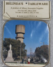
Memorabilia - Souvenir Coaster Woodland Grove Wodonga, Albury Souvenir Supplies, C. 1980s
A range of souvenirs depicting local landmarks were produced to represent and promote Wodonga and other towns throughout much of the 20th century. THE WATER TOWER is a major landmark of High Street, Wodonga. It began operation from 1924 until it ceased operation in 1959. It stood unused for a decade until the lower section was modified and put to use as “The Tower’s Cobbler’s Inn” in 1962. In 1972 Wodonga City Council proposed to demolish the Tower. Their suggestion received an unfavorable response from the city’s citizens, so the Tower still stands today. THE SOLDIERS' MEMORIAL in Wodonga was unveiled on Tuesday 18th November 1924. The soldier statue on the top has since been removed and placed in the RSL rooms, WodongaAn unopened packet containing a souvenir drink coaster representing Wodonga, Victoria. The coaster is a coloured photo of the Water Tower and Soldiers' Memorial in High Street, Wodonga.Beneath the photo "WATER TOWER, WODONGA, VICsouvenirs wodonga, water tower, memorials, woodland grove -
 Federation University Art Collection
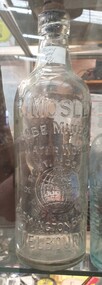
Photograph, R. Mosley Mineral Water Bottle
Robert Mosely was an aerated water and cordial manufacturer. in 1909 Robert Mosley married Isabel Ethel Shepherd Stevens (or Steens). (Victorian Marriage Records, 1909) He died in 1936. MOSLEY. - On the 28th June at a private hospital, Melbourne, Robert, the dearly loved husband of Ethel Mosley, of 31 Ormond road, Moonee Ponds, loving father of Florrie (Mrs. Bayne), Jane, and Bessie (Mrs. Read), loving stepfather of Gladys (Mrs Myers) and Esma Campion, aged 75 years. — At rest. (The Argus, 29 June 1936) MOSLEY. — On the 28th June, at a private hospital, Melbourne, Robert Mosley, of 31 Ormond-road, Moonee Ponds. At rest. (The Age, 29 June 1936)Glass bottle made for Robert Mosely of Flemington Bridge, Melbourne. The 1896 Mosley bottles was manufactured in England and Victoria (t Mr Corfield's in Exhibition Street, Melbourne. )r. mosley, robert mosley, mineral water, flemington, globe mineral water works, flemington bridge -
Tatura Irrigation & Wartime Camps Museum
Photograph, Big Eildon Under Construction, 1954
Taken by photographer for State Rivers and Water Supply Commission. Taken at Mount SugarloafLarge sepia photograph. Rocks and uprooted trees in foreground, temporary wooden huts and truck, middle distance terraced earthen dam wall, left of wall water dammed back rounded hills beyond.Bottom edge of photo: "State Rivers and Water Supply Commission / BIG EILDON UNDER CONSTRUCTION."victoria state rivers and water supply commission, eildon, eildon dam -
 Ringwood and District Historical Society
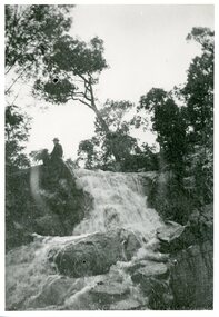
Photograph, Loughnan Lake overflow c.1930, c.1930
Loughnan Lake overflow c.1930. Strong flow of water over waterfall. Man & dog sitting at top of the waterfall. -
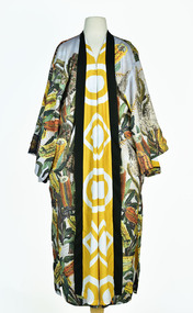 National Wool Museum
Textile - Cloak, Dr Deanne Gilson, Banksia Tree Cloak (water and fire business), 2022
Standing proud, still here, the spirit of ten ancestral matriarchs adorned in contemporary ceremonial cloaks. Representing our women past, present and future, her Spirit, our culture, our Country (spelt with a capital for its importance and this is part of First Peoples protocols on acknowledging Country, our strength, our resilience and healing towards a sustainable future).The sacred banksia tree was a favourite for Wadawurrung people. Flowering before deep Winter, the banksia was used for spear making and other wooden tools. The sap was drunk as a sweet drink and the seed pods used for water straining and fire sticks. The banksia tree flowers at the time when fire sticks farming is practiced marking the days before the coldest days and nights and the hotter days.White, orange, and yellow banksia design on outer cloak, yellow and white circle and diamond design in lining. Solid black trimming. Cloak is machine sewn and handstitched with hand stitching on shoulder seam.deanne gilson, wadawurrung dja, first nations art, cloak -
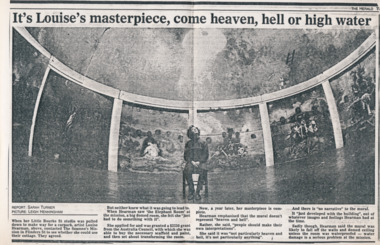 Mission to Seafarers Victoria
Article - Clipping, photocopy, Sarah Turner, It’s Louise’s masterpiece, come heaven, hell or high water, 1988
Louise Hearman used the Norla Dome and painted a mural painted which had taken her around a year to complete. The exhibition called Elephant Room was shown from June 1988. The work was vandalised in 1989 and subsequently demolished.Louise Hearman is a Melbourne born artist and Archibald Prize winner. Hearman first came to public notice in 1987/88 when she spent a year painting the mural in the Norla Dome. The premises of the Mission also served as her studio at that time.Black and white copy of a newspaper article, printed on A3 paper.It’s Louise’s masterpiece, come heaven, hell or high water Report: SARAH TURNER PICTURE: LEIGH HENNINGHAM When her Little Bourke St studio was pulled down to make way for a carpark, artist Louise Hearman, above, contacted The Seamen’s Mission in Flinders St to see whether she could use their cottage. They agree. But neither knew what it was going to lead to. When Hearman saw ‘the Elephant Room’ at the mission, a big domed room, she felt she “just had to do something with it”. She applied for and was granted a $3250 grant from the Australia Council, with which she was able to buy the necessary scaffold and paint, and then set about transforming the room. Now, a year later, her masterpiece is complete. Hearman emphasised the the mural doesn’t represent “heaven and hell”. Rather, she said, “people should make their own interpretations”. She said it was “not particularly heaven and hell, it’s not particularly anything”. And there is “no narrative” to the mural. It “just developed with the building”, out of whatever images and feeling Hearman had at the time. Sadly though, Hearman said the mural was likely to fall off the walls and domed ceiling unless the room was waterproofed - water damage is a serious problem at the mission. louise hearman, norla dome, exhibitions, 1988, elephant room, flinders street, melbourne, leigh henningham, cultural events -
Tatura Irrigation & Wartime Camps Museum
Photograph, Minor Outlet from Waranga Basin, 1957
Taken by photographer for State Rivers and Water Supply Commission.Large, black and white photograph. Large square concrete building set in stone wall, water right foreground, stones left foreground, two men on top of wall left of building, windmill just visible above roof of buildingbelow photo: "Minor outlet from Waranga Basin / Supplies water to parts of West Rodney and Tongala Districts."victoria state rivers and water supply commission, waranga basin, irrigation -
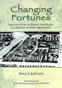 Port Melbourne Historical & Preservation Society
Book, David Radcliffe, Changing Fortunes, March 2021
"Ebb and flow of people and places in a pocket of Port Melbourne " Also contains many references throughout the book to PMHPS collectionWhat it was like to live around the upper reaches of the former Sandridge Lagoon from pre settlement times up until the 1940s. It locates the history of many families who built their dreams on a pocket of reclaimed land in Port Melbourne in the 1880s "Ebb and flow of people and places in a pocket of Port Melbourne" Soft cover book. Green in colour with images of aerial photo of port Melbourne on front and back covers. On back page "once as it was - Boon Wurrong Foundation" yalukit willam, boon-warrung, george beazley, anne chaffey, swallow & ariell ltd, port melbourne town hall, sandridge lagoon, business and traders - milkbars, spring street, esplanade east, built environment - commercial, built environment - domestic, domestic life -
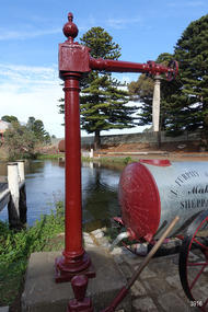 Flagstaff Hill Maritime Museum and Village
Functional object - Water standpipe, Langlands Bros. & Co, 1880-1893
This water standpipe is believed to be the only one of its kind in working order. It was originally located in Warrnambool, on the hillside at the corner of Mickle Crescent and Banyan Street, providing water for the Chinese Market Gardens below, on the flats. It was removed from this location on May 2nd, 1979, with the intention to relocate it at the new Flagstaff Hill Maritime Museum & Village. The standpipe lay in storage for years until the Warrnambool Company, Chemblast, offered to restore it for use as a working display. The display was officially opened on March 31, 2014. The water from the adjacent lake is drawn out with a hand operated water pump, and goes up into the standpipe, where flows through the canvas hose and into the top of the Furphy Farm Water Cart. The display is a visual acknowledgement of the years served by Flagstaff Hill volunteer and Friends of Flagstaff Hill Chairperson, Bob Crossman. Warrnambool’s early settlers had no water supply prior to the mid-1850s. They relied on rain water tanks, domestic wells and springs. The town experienced a huge, destructive fire in William Bateman Jnr. & Co.’s large produce store in November 1856, which highlighted the need for both a fire brigade and a good supply of water. In 1863 a volunteer fire brigade was established. In August 1880 the town celebrated the installation of its first water standpipe on the corner of Liebig and Timor streets. The water was pumped from springs at Cannon Hill through the connected pipeline to the standpipe, then distributed to households via horse and cart. Each of the licenced cart drivers were compelled by Council regulations to keep their carts full from sunset to sunrise, ready to cart water to outbreaks of fire. They received a fee for this service. In 1893 the town installed a water supply, sourced from the Merri River, stored in a reservoir basin and tower in north Liebig Street, and distributed throughout the town in a system of pipes. By late 1939 a reticulated supply was installed, with the water piped in under the Otway Scheme. Standpipes are still used in modern times in rural and remote areas for homes, farms, stock, agriculture and firefighting. Many commercial or government owned standpipes are metered, charging a fee for the quantities of water supplied. This water standpipe was made by Langlands Foundry Co. Limited, Melbourne, which was establish in 1842. It was Melbourne’s first foundry and iron shipbuilder, and one of the largest employers in Victoria at the time. Langlands was known for its high quality workmanship and wide range of goods for mining, engineering, marine, railway and other industrial uses. The company made the first cast bell, the first lamp posts in the colony, and the boiler for the first Australian train. In the 1860s it produced cast iron pipes for the Board of Works, which laid the pipes for Melbourne’s first reticulated water supply. The firm was bought by Austral Otis Co. in 1897.This water standpipe is significant historically as it is believed to be the only one of its type in working condition. The standpipe is significant for being manufactured by early colonial firm Langlands Foundry of Melbourne, which was known for high quality, cast iron products. The firm made the boiler for the first Australian train, assembled the first Australian paddle steamer and made the first Australian cast bell and lamp posts. Langlands was one of the largest employers in Victoria at the time. The standpipe is significant historically as it represents the evolution of water supply services in Australia. Standpipe; vertical cast iron water pipe, painted crimson, fixed in position, tapering inward from the round base to the rectangular joint near the finial on top. A hexagonal pipe extends at right angles from the joint, with an outlet fitting and flow-controlling wheel on the end. A length of canvas hose hangs from the outlet fitting. Inscriptions are on one face of the joint. The standpipe was made by Langlands Foundry Company of Melbourne. Embossed “LANGLANDS FOUNDRY CO. / LIMITED / ENGINEERS / MELBOURNE”warrnambool, flagstaff hill maritime museum, maritime museum, shipwreck coast, flagstaff hill maritime village, great ocean road, flagstaff hill, standpipe, stand-pipe, water standpipe, fire standpipe, firefighting equipment, water supply equipment, chinese market gardens, banyan street, liebig street, water tower, bateman’s fire, working display, water supply, town water, rural water, reticulated water, cannon hill spring, merri river, otway water, water carters, horse and cart water supply, volunteer fire brigade, langlands foundry, early melbourne, iron works, bob crossman, late 19th century water supply -
Glenelg Shire Council Cultural Collection
Slide - Slide - Cashmore Airport, Portland, 1980s
Coloured slide. Concrete retaining wall at end of trench. Tunnel through concrete to allow water flow. Cashmore airport construction site.portland airport, cashmore airport, air travel, development