Showing 1122 items
matching waterway
-
 Lakes Entrance Historical Society
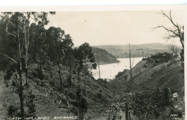
Postcard - North Arm, Valentine Series, 1920c
No. 1 from Valentine Series of small postcardsBlack and white postcard showing lower reach of North Arm, and gully. Vegetation has been removed from both sides of gully. Lakes Entrance VictoriaNorth Arm Lakes Entrance topography, waterways -
 Lakes Entrance Historical Society
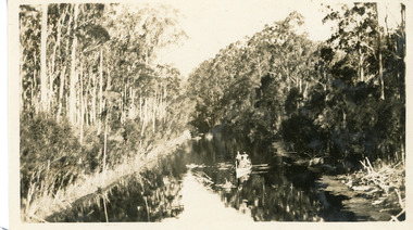
Photograph - North Arm, 1926c
Black and white photograph showing upper reaches of North Arm. Small rowing boat with several people standing in boat. Reflection of vegetation on water. Lakes Entrance Victoriatopography, waterways -
 Lakes Entrance Historical Society
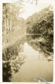
Photograph - North Arm, 1924
Black and white small format photograph showing upper reaches of North Arm. Reflections of vegetation on water. Lakes Entrance Victoriatopography, waterways -
 Lakes Entrance Historical Society
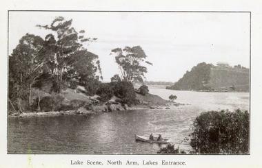
Photograph - North Arm, 1920c
Copy same view but titled 'North Arm - Lakes Entrance' 11.5 x 18Black and white photograph of the North Arm. It shows the calm waters of the arm which twist and turn between high scrub covered banks. Distant view of township, two people in small boat in foreground. Lakes Entrance VictoriaLakes Scene North Arm Lakes Entrancevegetation, topography, waterways -
 Lakes Entrance Historical Society
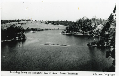
Photograph - North Arm, Bulmer H D, 1930c
Black and white photograph of the North Arm, showing the calm waters between steep banks covered in natural vegetation, but for one hillside which has been almost completely cleared, a few ring barked trees still standing. Lakes Entrance VictoriaLooking down the beautiful North Arm Lakes Entrancevegetation, waterways, topography -
 Lakes Entrance Historical Society
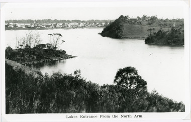
Photograph - Lakes Entrance, 1940c
Black and white photograph of the township from the North Arm. It shows the calm waters between steep shorelines covered in natural vegetation and scrub. Lakes Entrance VictoriaLakes Entrance from the North Armvegetation, topography, waterways, township -
 Lakes Entrance Historical Society
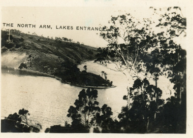
Postcard - North Arm, 1924
Second copy 6 x 8 with inscription 'North Arm Lakes Entrance'Black and white postcard of a view down the North Arm, showing the calm waters of the lake, natural vegetation in foreground, reflections of trees on the water. Lakes Entrance VictoriaThe North Arm Lakes Entrancewaterways, vegetation -
 Lakes Entrance Historical Society
Photograph - Entrance Piers, Phillips Miss L, 1895c
Two other copies black and white, 9 x 14cmBlack and white photograph showing piers and entrance to Gippsland Lakes from ocean Bass Strait. Western pier shows concrete extension, eastern pier shows workshed at end. Lakes Entrance Victoriapiers, waterways -
 Lakes Entrance Historical Society
Photograph - Entrance Piers, 1890c
Sepia photograph showing entrance from ocean Bass Strait to Gippsland Lakes. Early wooden piers, trading ship being towed out through entrance by small steamer, beach and boardwalk in foreground. Lakes Entrance VictoriaLakes Entrancejetties, ocean, waterways, public works -
 Lakes Entrance Historical Society
Photograph - Wombat, 1890c
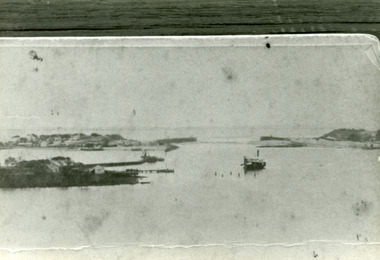
1 other photograph 10 x 16 archived.Black and white photograph showing view of entrance, dunes and Bullock Island, buildings and dunes at left, building and jetty and rock groynes on Bullock Island. Vessel near centre may be the Carpenter owned dredge the Wombat. Lakes Entrance Victoria jetties, dredges, waterways -
 Lakes Entrance Historical Society
Photograph - The Entrance, Goff, Russell, 1986c
Black and white photograph of the entrance and Bullock Island showing the western end of Bullock Island formed by successive dumping of dredged sand. Lakes Entrance Victoriajetties, ocean, waterways, islands -
 Lakes Entrance Historical Society
Photograph - The Entrance, 1890c
One other copy same sizeBlack and white photograph of newly opened entrance to Gippsland Lakes from Bass Strait, Lakes Entrance, Victoria.boats and boating, waterways, piers -
 Lakes Entrance Historical Society
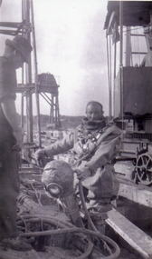
Photograph, 1915c
Black and white photograph showing man in diving suit, holding diving helmet, machinery on tram lines, second man on left of photo at Lakes Entrance, Victoria.waterways, jetties, public works, divers -
 Lakes Entrance Historical Society
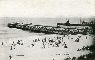
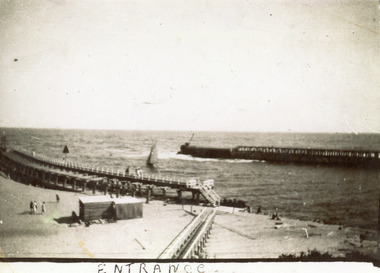
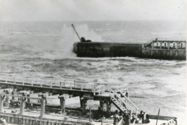
Photograph - Entrance Beach, Bulmer H D, 1910c
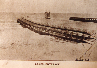
One other copy slightly sepia tinted 12 x 19cmBlack and white photograph showing piers and entrance to Gippsland Lakes from ocean Bass Strait. Work in progress on concrete extension to western pier showing cranes and machinery in use. People on beach and piers. Lakes Entrance VictoriaLakes Entrancewaterways, beaches, piers, machinery -
 Lakes Entrance Historical Society
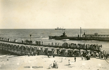
Photograph - Entrance Piers, Bulmer and Segerberg, 1910c
Black and white photograph showing piers and entrance to Gippsland Lakes from ocean Bass Strait. Crowd of people on eastern pier and beach. Concrete extension to western pier in progress, two cranes. Steam ship with sails out at sea. Lakes Entrance VictoriaLakes Entrancewaterways, boardwalk, ships and shipping, piers -
 Lakes Entrance Historical Society
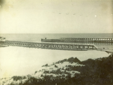
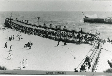
Photograph - Entrance Beach, Bulmer H D, 1915c
Black and white photograph showing entrance piers and entrance to Gippsland Lakes from ocean Bass Strait. Extensions to both piers completed. Visitors on pier and boardwalk. Lakes Entrance VictoriaLakes Entrancewaterways, boardwalk, beaches, piers -
 Lakes Entrance Historical Society
Photograph - Entrance Piers, 1890c
Black and white photograph showing newly constructed piers at entrance to Gippsland Lakes from ocean Bass Strait. Photo shows distress rocket set up on beach with two people. Lakes Entrance Victoria waterways, piers -
 Lakes Entrance Historical Society
Photograph - Entrance Piers, 1905c
Black and white photograph showing piers and entrance to Gippsland Lakes from ocean Bass Strait. Few people on boardwalk on piers. Lakes Entrance Victoriaboardwalk, waterways, piers -
 Lakes Entrance Historical Society
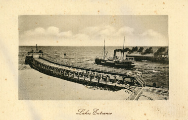
Postcard - S.S. Wyralla, 1920c
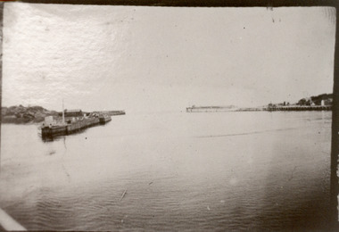
Postcard printed in Germany has serrated edging. Also another sepia toned copy 10 x 15cm.Black and white postcard showing SS Wyralla steaming out entrance into Bass Strait, lot of smoke. Workshed on end of eastern pier. No-one on piers or beach on left of eastern pier. Boardwalk on right on end of pier. Tramline visible. waterways, piers, ships and shipping -
 Lakes Entrance Historical Society
Photograph - The Entrance, 1920c
Black and white photograph showing wooden piers with newly completed concrete extensions. Rough seas breaking in entrance to Gippsland Lakes from ocean Bass Strait. Kiosk by boardwalk closed. Lakes Entrance Victoriaboardwalk, waterways, beaches, piers -
 Lakes Entrance Historical Society
Photograph - The Entrance, 1920c
Second copy 10 x 15 brownish toningBlack and white photograph showing piers at entrance to Gippsland Lakes from ocean Bass Strait. Sailing boat in entrance. Kiosk on sand between eastern pier and boardwalk. Few people on beach. Lakes Entrance VictoriaEntranceboardwalk, waterways, piers, boats and boating -
 Lakes Entrance Historical Society
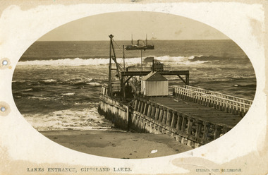
Postcard - Eastern Pier, Vogt, Stanley, 1910c
Oval shaped picture. Also other copies, oval shaped 12.5 x 17.5 cm and 17.5 x 25 cm. Also two black and white prints 9 x 13 cm.Sepia postcard in cameo image, showing early view of eastern pier at the entrance to Gippsland Lakes from ocean - Bass Strait, at Lakes Entrance, Victoria. Photo shows work shed and crane at end of wooden eastern pier, SS Wyralla at sea.Lakes Entrance, Gippsland Lakes machinery, waterways, piers, ships and shipping -
 Lakes Entrance Historical Society
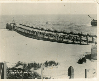
Postcard - The Entrance, Valentine Series, 1920c
One sepia copy 7 x 8.5 cm, also black and white copy 9 x 15 cm (Valentine Series)Small format postcard showing eastern pier and tip of western pier at entrance to Gippsland Lakes from ocean - Bass Strait at Lakes Entrance, Victoria. Side of kiosk on right hand side, beach in middle ground, post and barb wire fence lower foreground.The Piers Lakes Entrance waterways, piers -
 Lakes Entrance Historical Society
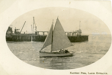
Postcard - Eastern Pier, 1910c
Second copy same imageSepia postcard in cameo image, showing small sailing boat in entrance to the Gippsland Lakes, at Lakes Entrance, Victoria, with wooden eastern pier behind machinery on pier, travelling steam crane on left, 6 - 7 people in boat.Eastern Pier Lakes Entrance waterways, piers, boats and boating -
 Lakes Entrance Historical Society
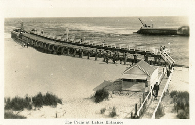
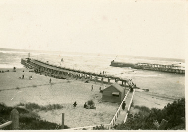
Postcard - Entrance Beach, 1920c
One other copy black and white 11.5 x 20 cmSepia postcard showing east and west piers and entrance from ocean - Bass Strait into Gippsland Lakes, at Lakes Entrance, Victoria. Several people on upper deck of eastern pier and on beach and boardwalk.The Piers at Lakes Entrancewaterways, piers, beaches, kiosk -
 Lakes Entrance Historical Society
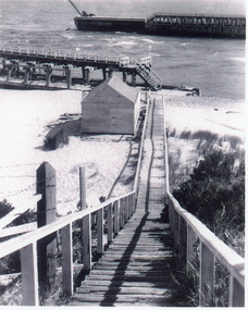
Photograph - Entrance Beach, 1917c
One other copy enlarged 25 x 17.5 cmBlack and white photograph showing tip of western pier and north end of eastern pier at entrance to Gippsland Lakes from ocean Bass Strait. Boardwalk and kiosk on beach, window of kiosk closed. Lakes Entrance Victoria waterways, restaurant, beaches, boardwalk -
 Lakes Entrance Historical Society
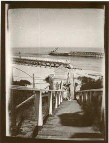
Photograph - The Entrance, 1920c
Black and white photograph showing entrance to Gippsland Lakes from ocean Bass Strait. People in 1920s style dress on boardwalk. Kiosk on beach closed. Vegetation either side of boardwalk. Lakes Entrance Victoria waterways, piers, kiosk -
 Lakes Entrance Historical Society
Photograph - The Entrance
Black and white photograph showing piers and entrance from ocean - Bass Strait. Concrete extensions completed, kiosk next to boardwalk. Appears to be cold day, few people about, wearing coats and sheltering behind tussocks, kiosk window half open.boardwalk, restaurant, waterways, beaches -
 Lakes Entrance Historical Society
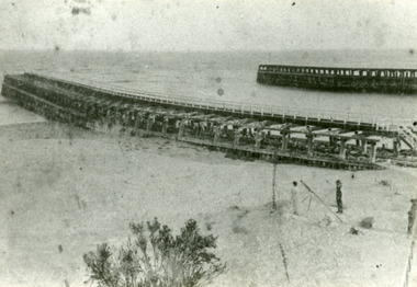
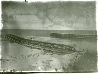
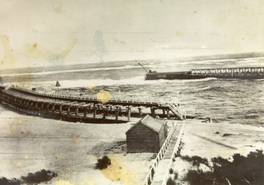
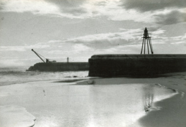
Photograph - Entrance Piers, 1917c
Black and white photograph showing concrete extensions to original piers at entrance to Gippsland Lakes from ocean Bass Strait. Eastern pier in foreground finished, western pier in background not finished, crane still in use. Beach in foreground. Lakes Entrance Victoriapiers, waterways -
 Lakes Entrance Historical Society
Photograph - Western Pier, 1918c
Black and white photograph showing piers and entrance to lakes from ocean Bass Strait. Western pier in back ground shows concrete extension to original wooden pier. Wooden eastern pier in foreground. Lakes Entrance Victoriapiers, waterways