Showing 576 items matching "yarra yarra district"
-
 Eltham District Historical Society Inc
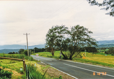
Photograph, Widened road reserve near Memorial Tower, Eltham-Yarra Glen Road, Kangaroo Ground, 6 December 1992, 06/12/1992
The Eltham Horse Trail: Research and Warrandyte to Kinglake: Survey of proposed route, December 1992: (2) Warrandyte to Kangaroo GroundColour photographeltham horse trail (1992 survey), kangaroo ground, eltham-yarra glen road, war memorial tower -
 Eltham District Historical Society Inc
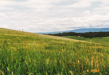
Photograph, Looking north from Eltham-Yarra Glen Road, Kangaroo Ground, 6 December 1992, 06/12/1992
The Eltham Horse Trail: Research and Warrandyte to Kinglake: Survey of proposed route, December 1992: (2) Warrandyte to Kangaroo Ground, trail route to be determined (1992)Four colour photographseltham horse trail (1992 survey), kangaroo ground, eltham-yarra glen road -
 Eltham District Historical Society Inc
Negative - Photograph, Carl Walter 1831-1907, Coffer dam in the Yarra River at Anderson's Creek, 1864
... Eltham District Historical Society Inc 728 Main Rd Eltham ...1864 photograph of the Coffer Dam in the River Yarra situated (approximately) opposite Whipstick Gully. Remains of bridge built in 1860(?) wrecked by 1863 flood in background. Reproduced page 29 of ‘Pioneers & Painters’ Gold was first discovered in this area at Andersons Creek (Warrandyte) in June 1851 by Louis Michel. Discoveries north of the Yarra did not occur until about 1854. Although it took some months for a true rush to develop it was not long before alluvial workings were being carried on in most of the Shire of Eltham. The last area in which gold was discovered was Kinglake. As the gold became harder to find, deep mining took over from alluvial diggings in the gullies. Perhaps the most extensive of the deep workings was the Diamond Creek Mine just outside the boundary of the Shire. This form of mining was continued into the 1930s. There are believed to be some mines in the area still capable of producing gold but present prices make working these uneconomical. Some gold is still found by weekend prospectors. Photo: Carl Walter 1831-1907 – inscribed on tent “C. Walter Photo” The State Library of Victoria holds over 150 photos by Carl Walter, most of which are portraits of Aboriginal natives including William Barak.This photo forms part of a collection of photographs gathered by the Shire of Eltham for their centenary project book,"Pioneers and Painters: 100 years of the Shire of Eltham" by Alan Marshall (1971). The collection of over 500 images is held in partnership between Eltham District Historical Society and Yarra Plenty Regional Library (Eltham Library) and is now formally known as 'The Shire of Eltham Pioneers Photograph Collection.' It is significant in being the first community sourced collection representing the places and people of the Shire's first one hundred years.Digital image 4 x 5 inch B&W Neg (2) Print 20 x 25 cmshire of eltham pioneers photograph collection, anderson's creek, coffer dam, floods, gold mining, other areas, pioneers and painters, warrandyte, warrandyte bridge, yarra river -
 Eltham District Historical Society Inc
Photograph, Heidelberg - River Yarra in flood at Heidelberg, 1934, 1934
... in partnership between Eltham District Historical Society and Yarra ...This photo forms part of a collection of photographs gathered by the Shire of Eltham for their centenary project book,"Pioneers and Painters: 100 years of the Shire of Eltham" by Alan Marshall (1971). The collection of over 500 images is held in partnership between Eltham District Historical Society and Yarra Plenty Regional Library (Eltham Library) and is now formally known as the 'The Shire of Eltham Pioneers Photograph Collection.' It is significant in being the first community sourced collection representing the places and people of the Shire's first one hundred years.Digital imagesepp, shire of eltham pioneers photograph collection, other areas, yarra river, floods -
 Eltham District Historical Society Inc
Negative - Photograph, Diamond Creek floodwater at Monash Bridge, Hurstbridge, Dec. 1934
... District Historical Society and Yarra Plenty Regional Library ...The historic 1934 flood of the Diamond Creek and Yarra River following the storms of 29-30 November set the levels for future planning with respect to flood water rise.This photo forms part of a collection of photographs gathered by the Shire of Eltham for their centenary project book,"Pioneers and Painters: 100 years of the Shire of Eltham" by Alan Marshall (1971). The collection of over 500 images is held in partnership between Eltham District Historical Society and Yarra Plenty Regional Library (Eltham Library) and is now formally known as the 'The Shire of Eltham Pioneers Photograph Collection.' It is significant in being the first community sourced collection representing the places and people of the Shire's first one hundred years.Digital image 4 x 5 inch B&W Negshire of eltham pioneers photograph collection, hurstbridge, 1934 flood, floods, monash bridge, diamond creek (creek) -
 Eltham District Historical Society Inc
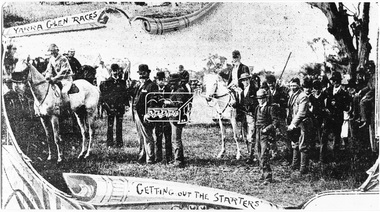
Photograph, Yarra Glen Races "Getting out the Starters" (reproduced from "The Leader", Jan. 6th, 1894, page 31)
... Eltham District Historical Society Inc 728 Main Rd Eltham ...Source: Mrs. E.W. Motschall (nee Marjorie Smith), Long Gully Road, Panton HillThis photo forms part of a collection of photographs gathered by the Shire of Eltham for their centenary project book,"Pioneers and Painters: 100 years of the Shire of Eltham" by Alan Marshall (1971). The collection of over 500 images is held in partnership between Eltham District Historical Society and Yarra Plenty Regional Library (Eltham Library) and is now formally known as the 'The Shire of Eltham Pioneers Photograph Collection.' It is significant in being the first community sourced collection representing the places and people of the Shire's first one hundred years.Digital imagesepp, shire of eltham pioneers photograph collection, yarra glen, cave hill, steels creek, yarra glen races -
 Eltham District Historical Society Inc
Folder, Birralee, 8 Yarra Braes Road, Eltham South
Morrison Kleeman Real Estate sales information material1 documents, 2 pages A4 gayle blackwood collection, houses, morrison kleeman real estate, birralee, yarra braes road, eltham south -
 Eltham District Historical Society Inc
Photograph, Peter Bassett-Smith, Upper Yarra Dam, Spring Tour, 22 Oct 1995, 22/10/1995
EXPLORING THE UPPER YARRA (Newsletter No. 105, November 1995, by Bettina Woodburn) We enjoyed the Spring Excursion, this year "Exploring the Upper Yarra" - in spite of the constant rain and the countryside under the cloud cover, especially in the valleys, being mainly shiny shades of green. The occasional fields of buttercups, clumps of arum lilies and splendid rhododendron and other flowering bushes became very special. The Cobb and Co coach was warm and a cosy retreat as we zig-zagged on the highways and byways to glimpse the Yarra River, upstream and down, its secret places, and particularly the many bridges. Russell excelled as 'Poet Laureate', reading from Dacre Smyth's book. This 1979 publication includes paintings of all the bridges along the river with poems and brief descriptions of each one. Some of the bridges are in out of the way places and are not very well known. We looked forward to hearing the poetry as much as seeing the ' constructions'…Big Pat (was he short or tall, lean or fat? He did win the two hundred pound reward for discovering gold and had the creek named after him), about the 'Eddies'?, and the disliked 'meccano' bridge in Warburton, etc. etc. The hot roast lunch in the old Reefton Hotel was also most welcome. It was easy to imagine it peopled by miners and early settlers. Starting by crossing the new (1974) concrete bridge at Warrandyte we headed through Wonga Park with views to the Christmas Hills and to the escarpment of the Yering Gorge, which causes flood waters to back up through the Yarra Glen plain, so avoiding disasters downstream. At the end of a long driveway we found the wooden, privately owned Henley Bridge (1935 after the 1934 floods). This facilitates access to different parts of Henley Farm and to Lilydale. Everard Park, named after Blanche Shallard's father, a State Member for 17 years, below the Highway Yarra crossing was in need of care. It is 10 miles from Yarra Glen by road but, as "Yarra Marra” canoeists well know, 32 winding miles down by water. After more delightful countryside scenes we joined the Warburton Highway at Woori Yallock. From the old Railway Station at Launching Place the Centennial Trail for walkers, cyclists and ' horse riders has replaced the rails. The line from Lilydale was opened in 1901, and the last diesel freight train ran to Warburton in 1965. It continued to rain as we had morning tea in Warburton in a shelter between footbridges. From here we continued upstream past the Bridge to O'Shannasy Lodge and Reservoir, Starvation Creek, and the Peninsular tunnel (miners dug it as at Pound Bend) which we visited (scrambling down those steps!) on our return after lunch. Our furthermost point was the Upper Yarra Dam Reserve (and vast catchment area). Finished in 1957 after ten years work and 100 years after Yan Yean, it supplies much of Melbourne's water. After crossing the 30m Launching Place Bridge to the Eltham side of the Yarra and Healesville, we saw in the distance the Yarra Glen Timber Trestle Bridge over the river flats "the longest for years in the land it was said!" Harry's dream of "better weather over the Divide" unfortunately didn't come true, but I'm sure we 36 members will retain happy memories of a day that was wet and green and filled with Bridges. Bettina Woodburn - October 1995 Record of the Society's history of activities - Spring 1995 excursionColour photographactivities, upper yarra dam, 1995, peter bassett-smith -
 Eltham District Historical Society Inc
Photograph, Peter Bassett-Smith, Upper Yarra Dam, Spring Tour, 22 Oct 1995, 22/10/1995
EXPLORING THE UPPER YARRA (Newsletter No. 105, November 1995, by Bettina Woodburn) We enjoyed the Spring Excursion, this year "Exploring the Upper Yarra" - in spite of the constant rain and the countryside under the cloud cover, especially in the valleys, being mainly shiny shades of green. The occasional fields of buttercups, clumps of arum lilies and splendid rhododendron and other flowering bushes became very special. The Cobb and Co coach was warm and a cosy retreat as we zig-zagged on the highways and byways to glimpse the Yarra River, upstream and down, its secret places, and particularly the many bridges. Russell excelled as 'Poet Laureate', reading from Dacre Smyth's book. This 1979 publication includes paintings of all the bridges along the river with poems and brief descriptions of each one. Some of the bridges are in out of the way places and are not very well known. We looked forward to hearing the poetry as much as seeing the ' constructions'…Big Pat (was he short or tall, lean or fat? He did win the two hundred pound reward for discovering gold and had the creek named after him), about the 'Eddies'?, and the disliked 'meccano' bridge in Warburton, etc. etc. The hot roast lunch in the old Reefton Hotel was also most welcome. It was easy to imagine it peopled by miners and early settlers. Starting by crossing the new (1974) concrete bridge at Warrandyte we headed through Wonga Park with views to the Christmas Hills and to the escarpment of the Yering Gorge, which causes flood waters to back up through the Yarra Glen plain, so avoiding disasters downstream. At the end of a long driveway we found the wooden, privately owned Henley Bridge (1935 after the 1934 floods). This facilitates access to different parts of Henley Farm and to Lilydale. Everard Park, named after Blanche Shallard's father, a State Member for 17 years, below the Highway Yarra crossing was in need of care. It is 10 miles from Yarra Glen by road but, as "Yarra Marra” canoeists well know, 32 winding miles down by water. After more delightful countryside scenes we joined the Warburton Highway at Woori Yallock. From the old Railway Station at Launching Place the Centennial Trail for walkers, cyclists and ' horse riders has replaced the rails. The line from Lilydale was opened in 1901, and the last diesel freight train ran to Warburton in 1965. It continued to rain as we had morning tea in Warburton in a shelter between footbridges. From here we continued upstream past the Bridge to O'Shannasy Lodge and Reservoir, Starvation Creek, and the Peninsular tunnel (miners dug it as at Pound Bend) which we visited (scrambling down those steps!) on our return after lunch. Our furthermost point was the Upper Yarra Dam Reserve (and vast catchment area). Finished in 1957 after ten years work and 100 years after Yan Yean, it supplies much of Melbourne's water. After crossing the 30m Launching Place Bridge to the Eltham side of the Yarra and Healesville, we saw in the distance the Yarra Glen Timber Trestle Bridge over the river flats "the longest for years in the land it was said!" Harry's dream of "better weather over the Divide" unfortunately didn't come true, but I'm sure we 36 members will retain happy memories of a day that was wet and green and filled with Bridges. Bettina Woodburn - October 1995 Record of the Society's history of activities - Spring 1995 excursionColour photographactivities, upper yarra dam, 1995 -
 Eltham District Historical Society Inc
Photograph, Birch Cottage, Eltham-Yarra Glen Road, c.1970, 1970
GC advised that when they first arrived in Eltham in the late 1960s, he would enjoy driving out to Yarra Glen. The Eltham-Yarra Glen road was unmade at the time. He passed this residence on the north side of the road. It was totally remote. GC found the juxtaposition of this little cottage with its surburban wire gate out in the remoteness of the landscape intriguing. Since then the road has been reconstructed and diverted away from the cottage which is now owned by Parks Victoria.Digital TIFF file Scan of 35mm Ilford HP4 black and white transparencyIlford HP4birch cottage, christmas hills, early settlers, edwin samuel birch, eltham-yarra glen road, honor mary birch, honor mary williams, john hill, watsons creek -
 Eltham District Historical Society Inc
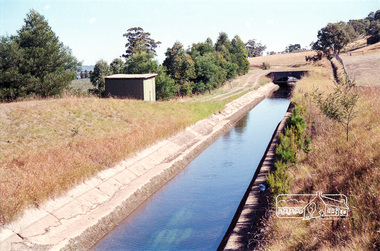
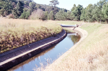
Photograph, Maroondah Aqueduct, Yarra Glen, 1991, 1991
Roll of 35mm colour negative film, 4 stripsKodak Gold 200-2 5096maroondah aqueduct, yarra glen -
 Eltham District Historical Society Inc
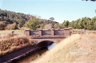
Photograph, Maroondah Aqueduct, Yarra Glen, 1991, 1991
Roll of 35mm colour negative film, 4 stripsKodak Gold 200-2 5096maroondah aqueduct, yarra glen -
 Eltham District Historical Society Inc
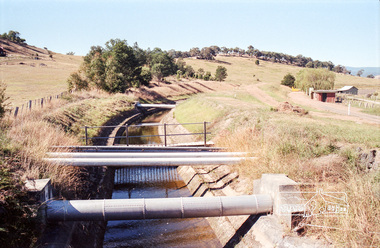
Photograph, Maroondah Aqueduct, Yarra Glen, 1991, 1991
Roll of 35mm colour negative film, 4 stripsKodak Gold 200-2 5096maroondah aqueduct, yarra glen -
 Eltham District Historical Society Inc
Photograph, Maroondah Aqueduct, Yarra Glen, 1991, 1991
Roll of 35mm colour negative film, 4 stripsKodak Gold 200-2 5096maroondah aqueduct, yarra glen -
 Eltham District Historical Society Inc
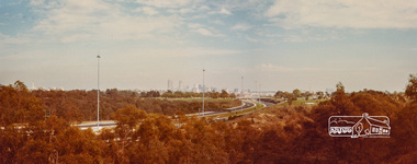
Negative - Photograph, Looking northeast from Eltham-Yarra Glen Road, Kangaroo Ground, 1998c
Roll of 35mm colour negative film, 8 strips and associated 10 x 15 cm colour printKodak Gold 100-5eltham-yarra glen road, kangaroo ground -
 Eltham District Historical Society Inc
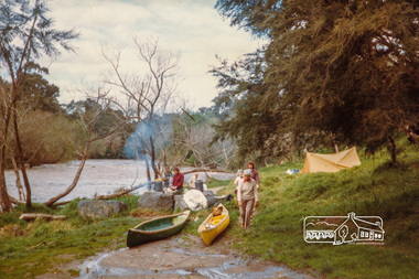
Photograph, Tent on Yarra River at Warrandyte
Originally contained in a 'magnetic' photo album of scenic photos of Yan Yean and Warrandyte believed to be donated by Mrs Eric Stephenson, Jingalong, 110 Ryans Road, Eltham, Vic. 3095; relocated to archival safe storage.Colour photographwarrandyte, yarra river -
 Eltham District Historical Society Inc
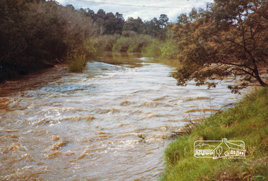
Photograph, High water, Yarra River at Templestowe
Originally contained in a 'magnetic' photo album of scenic photos of Yan Yean and Warrandyte believed to be donated by Mrs Eric Stephenson, Jingalong, 110 Ryans Road, Eltham, Vic. 3095; relocated to archival safe storage.Colour photographyarra river, templestowe -
 Eltham District Historical Society Inc
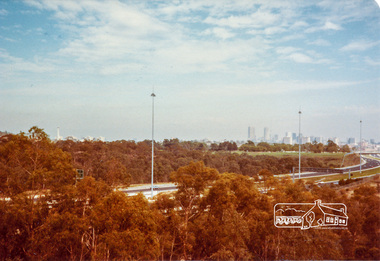
Photograph, Melbourne from Yarra Bend Park, Kew
Originally contained in a 'magnetic' photo album of scenic photos of Yan Yean and Warrandyte believed to be donated by Mrs Eric Stephenson, Jingalong, 110 Ryans Road, Eltham, Vic. 3095; relocated to archival safe storage.Colour photographkew, melbourne, yarra bend park -
 Eltham District Historical Society Inc
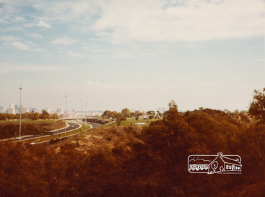
Photograph, Melbourne from Yarra Bend Park, Kew
Originally contained in a 'magnetic' photo album of scenic photos of Yan Yean and Warrandyte believed to be donated by Mrs Eric Stephenson, Jingalong, 110 Ryans Road, Eltham, Vic. 3095; relocated to archival safe storage.Colour photographkew, melbourne, yarra bend park -
 Eltham District Historical Society Inc
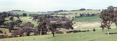
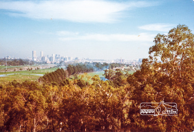
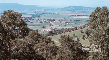
Photograph, Fred Mitchell, Yarra Glen Valley from lookout on Skyline Road, Yarra Glen, 1968, 1968
Digital copy of colour photographfred mitchell collection, 1968, skyline road, yarra glen -
 Eltham District Historical Society Inc
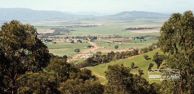
Photograph, Fred Mitchell, Yarra Glen Valley from lookout on Skyline Road, Yarra Glen, 1968, 1968
Digital copy of colour photographfred mitchell collection, 1968, skyline road, yarra glen -
 Eltham District Historical Society Inc
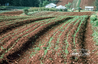
Photograph, Fred Mitchell, Market garden, Yarra Valley, 1980, 1980
Digital copy of colour photographfred mitchell collection, yarra valley, 1980, market gardens -
 Eltham District Historical Society Inc
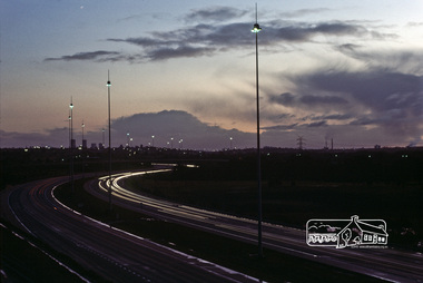
Photograph, Fred Mitchell, Yarra Valley, Bulleen, 1983, 1983
Digital copy of colour photographfred mitchell collection, 1983, yarra valley, bulleen