Showing 27535 items
matching yarra-river
-
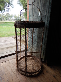 Parks Victoria - Days Mill and Farm
Container - Traps
Possibly used for catching freshwater crayfish or yabbies, nearby in the Goulburn River or other waterways. of critical significanceHOMEMADE WIRE TRAPS x 2. Made from chicken wire. Iron bands supported by green timber lengths. Wire handles with metal spike probably for securing trap to bank/ ground.fishing, food -
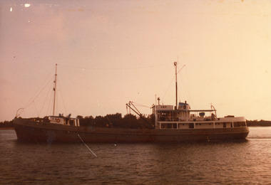 Lakes Entrance Regional Historical Society (operating as Lakes Entrance History Centre & Museum)
Photograph, 1980c
Skipper John Britton, Scott Hobson?, thought to be in mud in Tamar River, Tasm 2011Colour photograph of fishing boat Cowrie Bay which appears to be just outside Cunninghame Arm, the western side of the entrance and hummocks in background. Lakes Entrance Victoriafishing industry, ships and shipping, waterways, jetties, ocean -
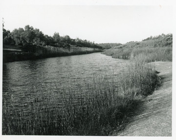 Lakes Entrance Regional Historical Society (operating as Lakes Entrance History Centre & Museum)
Photograph, Lakes Post Newspaper, 1993
The Warm Holes are the remnants of Reeves River, the original waterway of the natural entrance to the Gippsland Lakes.Black and white photograph of the fourth warm hole, looking eastward, Lakes Entrance, Victoria.roads and streets, waterways, islands, vegetation -
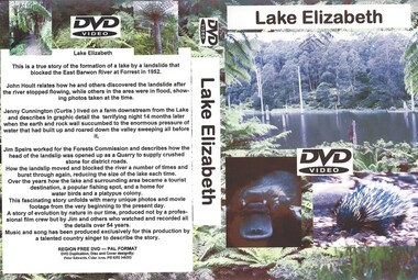 Otway Districts Historical Society
DVD, Lake Elizabeth, 2006
Lake Elizabeth was formed when a landslide slid into the valley damming the East Barwon River.Interviews with people who remember the formation of the Lake.30 Minute video of the creation of the lake in 1952lake elizabeth forrest east barwon -
 Brimbank City Council Art Collection
Reproduction black and white photograph, Flemington 1850
Photograph of re-enactment of the Australian landing at Gallipoli on Saltwater river. ANZAC day 1919Reproduction black and white photograph, 33 x 23 cm -
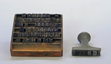 Orbost & District Historical Society
stamp holder and numbers, Victorian Government Railways, c. 1930s- 1980s
Used on the Orbost-Bairnsdale railway line which closed in 1987. The Bairnsdale-Orbost railway was opened in 1916 to serve the agricultural and timber industry. Because of the decline in traffic and heavy operating costs, the line was finally closed in August, 1987. Orbost Railway Station was opened on Monday 10 April 1916 as the terminus of the Orbost railway line, and closed in 1987. The station was located on the west side of the Snowy River despite the town of Orbost being on the east side of the river, in order to save on the costs of a bridge over the river, which at the time had highly variable levels This item is associated with the history of the Orbost-Bairnsdale railway line and therefore reflects the role that the rail line played in the social and economic history of Orbost.A stamp holder made of aluminium into which numbers and possibly letters can be inserted. Also a square shallow wooden box containing numbers which are used with the stamp. The numbers appear to be made of rubber.possibly V G R railway-history orbost-bairnsdale-railway -
 Orbost & District Historical Society
Victorian Railways pencil, Victorian Railways, c. 1960s-1980s
Used by Victorian Railways at stations on the Orbost-Bairnsdale line. The Bairnsdale-Orbost railway was opened in 1916 to serve the agricultural and timber industry. Because of the decline in traffic and heavy operating costs, the line was finally closed in August, 1987. Orbost Railway Station was opened on Monday 10 April 1916 as the terminus of the Orbost railway line, and closed in 1987. The station was located on the west side of the Snowy River despite the town of Orbost being on the east side of the river, in order to save on the costs of a bridge over the river, which at the time had highly variable levels. This item is associated with the history of the Orbost-Bairnsdale railway line and therefore reflects the role that the rail line played in the social and economic history of Orbost.A thick, hexagonal shaped pencil made of wood, painted dark blue, containing blue graphite marker.VICTORIA RAILWAYS written in gold lettering Emperor, Made in Australia railway-history victorian-railways orbost-bairnsdale-railway -
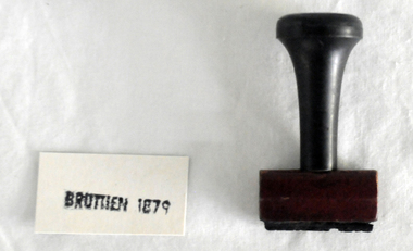 Orbost & District Historical Society
stamp, C 1960's
This stamp was used at the Orbost Railway Station. The Bairnsdale-Orbost railway was opened in 1916 to serve the agricultural and timber industry. Because of the decline in traffic and heavy operating costs, the line was finally closed in August, 1987. Orbost Railway Station was opened on Monday 10 April 1916 as the terminus of the Orbost railway line, and closed in 1987. The station was located on the west side of the Snowy River despite the town of Orbost being on the east side of the river, in order to save on the costs of a bridge over the river, which at the time had highly variable levels This item is associated with the history of the Orbost-Bairnsdale railway line and therefore reflects the role that the rail line played in the social and economic history of Orbost.A stamp with a black plastic handle. The bottom is wood and the stamp rubber. It has "BRUTHEN 1879" on it."BRUTHEN 1879"orbost-railway-station -
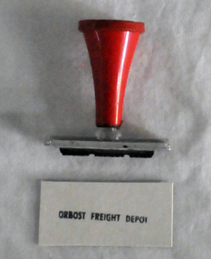 Orbost & District Historical Society
stamp, 1970's
This stamp was used at the Orbost Railway Station. The Bairnsdale-Orbost railway was opened in 1916 to serve the agricultural and timber industry. Because of the decline in traffic and heavy operating costs, the line was finally closed in August, 1987. Orbost Railway Station was opened on Monday 10 April 1916 as the terminus of the Orbost railway line, and closed in 1987. The station was located on the west side of the Snowy River despite the town of Orbost being on the east side of the river, in order to save on the costs of a bridge over the river, which at the time had highly variable levels, This item is associated with the history of the Orbost-Bairnsdale railway line and therefore reflects the role that the rail line played in the social and economic history of Orbost.A stamp with a red plastic handle and a white stamping face - "ORBOST FREIGHT DEPOT".VUESTAMP AUSTRALIAorbost-railway -
 Kiewa Valley Historical Society
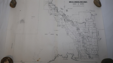
Map - Mullindolingong
Land owners of land in the Kiewa Valley in 1928The Kiewa Valley was farming country with families settling in the area prior to 1928 Two sheets the same: (one old with paper joined together and the other is a copy without any joins. 21 6 1928 dated Map of Mullindolingong / County of Bogong showing land owners along the Kiewa River and beyond.Produced by the Department of Lands and Survey, Melbournemullindolingong, kiewa valley, land owners, families of the kiewa valley -
 Federation University Historical Collection
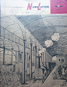
Magazine - Newsletter, Victorian Railways Newsletter, June 1967, 06/1957
Soft covered magazine of 16 pages. It includes an article of the Geelong Line centenary, and a photo of the original Geelong line laid with Barlow, or saddle-back rail; cement, Little River Station, , Renewing crossings, , memorial to railways returned servicement at the Ballarat NOrth Workkshops. victorian railwat, geelong railway centenary, cement, cp vans, railcrossings, trains -
 Glenelg Shire Council Cultural Collection
Souvenir - Souvenir Wine Glass, c. 1985
Wine glass, souvenir of Heywood's 150th 1835 - 1985. Gold rim on top, gold depiction of bullock dray, with 'Heywood 150th' above and '1835 - 1985' below, in gold. Opposite side of glass has history of the Heywood Fitzroy River bridge in gold print.souvenir, heywood, 150th anniversary, 1835 to 1985 -
Glenelg Shire Council Cultural Collection
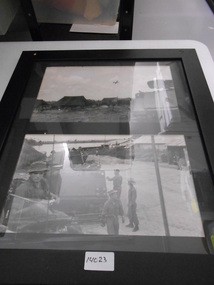
Photograph - Sheet of 2 contact prints - Various pastoral scenes, 1960-1970
Sheet of 2 contact prints from glass plate negatives. Top: Weatherboard house, verandah with iron lacework from roof, verandah roof striped. Several ladies and small children on verandah. Bottom: Five women standing on wooden jetty on river bank. -
 Warrnambool and District Historical Society Inc.
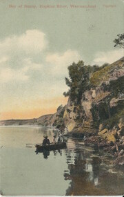
Cards, Post Cards Warrnambool, Early 20th century
These cards have been sent to Christina Lawrance (1889-1970). She was born in Williamstown, Victoria and married James Robertson in 1912. They lived in the Gundagai area of N.S.W. on a property named ‘Nargoon’ (sheep and cattle) and they had five children. One of the daughters, Margaret, married Jeffrey (Bill) Whitehead of ‘Goodwood’ near Hawkesdale and the cards have been passed on to us from a Whitehead descendant. It is not known who sent the cards to Christina Lawrance who would have been 16 or 17 at the time. These cards are of interest because they are of Warrnambool scenes and demonstrate the practice at the time (1906) of sending cards that had photographs of local scenes. The photographs, although printed in great numbers, are of historical interest today. The cards are also of interest because of the recipient’s connection with the Warrnambool area – Christina Lawrance is an important person in the family tree of the Whitehead families today. These are four colour post cards in green, yellow and black tonings. They have photographs of the Hopkins River, Warrnambool and the Hopkins Falls on one side. They all have a penny red Victorian stamp and were posted from Warrnambool in 1906. The address is handwritten in black ink. Addressed to: ‘Miss C. Lawrance, C/O Kirkpatricks Hotel, Mornington, Victoria’whitehead family of ‘goodwood’, christina robertson nee lawrance, history of warrnambool and district -
Bendigo Historical Society Inc.
Map - LYELL : COUNTY OF BENDIGO, 24-10-84
Map. Lyell, County of Bendigo, Eppalock, Sedgwick, Sutton Grange, Hawkestone, Kimbolton, Coliban River, Myrtle Creek. State School. Photo-Lithographed at the Department of Lands and Survey, Melbourne by J. Noune, 24-10-84. (number 71 in map cupboard 1)J. Nounemap, bendigo, lyell -
Bendigo Historical Society Inc.
Map - LYELL : COUNTY OF BENDIGO, 24-9-07
Map. Lyell, County of Bendigo, Sedgwick, Sutton Grange, Hawkestone, Kimbolton, Eppalock, Myrtle Creek, Coliban River. Photo-Lithographed at the Department of Lands and Survey, Melbourne by T.F. McGauran, 24-9-07, Price 1/-. (number 70 in map cupboard 1)T.F. McGauranmap, bendigo, lyell -
Bendigo Historical Society Inc.
Map - DERBY : COUNTY OF BENDIGO, 1-9-09
Map. Derby, County of Bendigo, Inglewood, Loddon River, Tarnagulla, Woodstock, Leichardt, Bridgewater, Bendigo to Inglewood Railway. Photo-Lithographed at the Department of Lands and Survey, Melbourne, by T.E. McGauran 1-9-09. Price 1/-. (number 55 in map cupboard 1)T.E. McGauranmap, bendigo, derby -
Bendigo Historical Society Inc.
Map - NOLAN, COUNTY OF BENDOGO, 7-5-30
Map, Nolan, County of Bendigo, Egerton; Elmore; Goornong. Campaspe River, Elmore Estate, By Authority: H.J.Green, Government Printer,Melbourne.Price 2/-.Drawn and Reproduced at the Dept. of Lands and Survey,Melbourne,Victoria.7-5-30. (number 1 in map cupboard 1)H.J.Green,Government Printermap, bendigo, nolan -
Port Melbourne Historical & Preservation Society
Flyer - Westgate Park, Melbourne and Metropolitan Board of Works, 1990s
Folded coloured flyer with stylised drawing of West Gate Bridge and a heron in black. Green stripe to represent the park and blue for the river. Group of buildings on left representing the city. The colour scheme continues in the folded pages . Maps of park and area, plus artists representation.parks and gardens, west gate bridge, westgate park, mmbw, melbourne and metropolitan board of works -
Bendigo Historical Society Inc.
Tool - INDIGENOUS STONE TOOL COLLECTION: STONE AXE HEAD, LODDON AREA
Dark brown stone axe head, semi circular in shape. Number 12 stuck on stone. Interpretive sign reads' Stone Age Implements, exhibits 11 - 15. All found on the banks of the Loddon River near Bridgewater, Victoria. Stone Axe Heads'first people, indigenous, loddon river, bridgewater -
 National Vietnam Veterans Museum (NVVM)
Photograph, APC's
Two times black and white Photograph of APC's and troops. Photo 1 - An unmanned APC sits unmanned near a tent camp. A C130 flys overhead. Photo 2- Two manned APC's on a village road nearby a river. ARVN and Australian troopers nearby.armoured personnel carrier, c-130 hercules, arvn, photograph -
Tatura Irrigation & Wartime Camps Museum
Packing Slip Envelope, pre 1990
Spencer Street Railway Station now known as Southern Cross.Regular size envelope, brown paper. Meant to hold packing slip. Has reinforced hole for tying to parcels. Wording indicates to be used at State Rivers and Water Supply Commission store yards at South Melbourne for Government carrier to Spencer Street Railway Station.To SRWSC Spencer St Railway Station per Government courier to SR & WSC store yard Brady Street South Melbourne. On rear are instructions to carrier.spencer street railway station, srwsc -
Lakes Entrance Regional Historical Society (operating as Lakes Entrance History Centre & Museum)
Book, Gippsland Heritage Journal No 11, 1991
Issue 11 of a series of Journals showcasing Gippsland history contains articles on Limestone Creek, Crooked River School, Inverloch, Port Albert, Wattle Bark Industry and dairy farming personalities sister Ellen Mc Carthy, Amos Brazier, John Lardner, Tomsettlers, schools, agriculture, industrial -
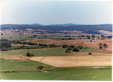 Lakes Entrance Regional Historical Society (operating as Lakes Entrance History Centre & Museum)
Photograph, Tambo Shire, 1994
Also second identical copyColour photograph of the Mossiface Flats, near Bruthen, shows paddocks of the rich river flats, timbered foothills in the distance, with mountain range behind. Some paddocks have been mown for grass hay. Farm buildings in foreground and background. Dam in foreground. Bruthen Victoriaanimals, agriculture, vegetation, topography -
 Kew Historical Society Inc
Photograph - Flood, Zig-Zag, Kew, 1924
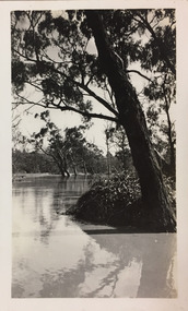
Henry Beater Christian (1886-1962) , was a descendant of one of the earliest settler families in Kew. Employed at the Kew Asylum as a 'public servant', he was a skilled amateur photographer, photographing numerous scenes in Kew and on his travels around Victoria. The majority of his photographs date from 1916 to 1929. His finest photographs are housed in two photograph albums. Digital copy of a photograph from page 5 of the 47-page photograph album containing 261 gelatinous silver images, loaned by Diane Washfold with permission given to digitise and hold a copy in our collection. This is a photograph of the river at Kew during a flood in January 1924."Flood / Zig-Zag Kew / 1.24"henry beater christian (1886-1962), landscape photography, kew (vic.) — yarra river, christian-washfold collection, photograph albums, floods -- yarra river -- kew (vic.) -
 Wodonga & District Historical Society Inc
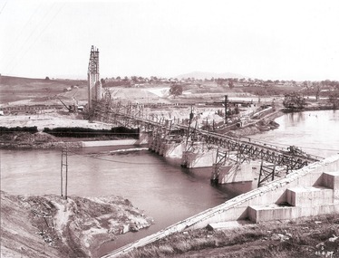
Album - Hume Reservoir Australia Album - General View of Works from New South Wales end, Looking Upstream, August 1927, 1927
This set of photos is from a leather bound album bearing the inscription "HUME RESERVOIR AUSTRALIA" plus 'The Rt. Hon. L. C. M. S. Amery, P. C., M .P.' all inscribed in gold. It was presented to The Rt. Hon. L. C. M. S. Amery, P. C., M. P, Secretary of State for Dominion Affairs on the occasion of his visit to the Hume Reservoir on 2nd November 1927. This album is of local and national significance as it documents the planning and development of the Hume Reservoir up to 1927. It was the largest water reservoir in the British Empire. The album records the pioneering engineering work that went into its construction.DEPARTMENT OF PUBLIC WORKS, N.S.W. RIVER MURRAY WATERS SCHEME. HUME RESERVOIR. 23. General view of works from the New South Wales end, looking downstream. The features are generally speaking the same as in the last view 22 (Record WHS 00716) in reverse.hume reservoir australia, river murray waters scheme, hume reservoir construction -
 National Vietnam Veterans Museum (NVVM)
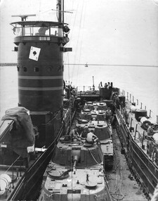
Photograph, Gibbons, Denis, Ace of Spades 1
Denis Gibbons (1937 – 2011) Trained with the Australian Army, before travelling to Vietnam in January 1966, Denis stayed with the 1st Australian Task Force in Nui Dat working as a photographer. For almost five years Gibbons toured with nine Australian infantry battalions, posting compelling war images from within many combat zones before being flown out in late November 1970 after sustaining injuries. The images held within the National Vietnam Veterans Museum make up the Gibbons Collection.A black and white photograph of the Australian Army Landing Craft the Vernon Sturdie or 'The Ace of Spades' as it makes its way up the Mekong River towards Long Binh to deliver American tanks to the Vietnamese Army. The Ace of Spades worked extensively in the Mekong Delta area.photograph, landing craft vernon sturdie, the ace of spades, mekong delta, long binh, gibbons collection catalogue, denis gibbons, photographer, vietnam war, vietnamese army -
 Eltham District Historical Society Inc
Photograph, Fay Bridge, Rosehill Homestead, EDHS Heritage Excursion, 6 July 2019
July Excursion July 6, 2019 - Exploring Lower Plenty The predominant feature of this walk in the Bonds Road area, Lower Plenty is the large number of magnificent old River Red Gums that line the route. These trees are of the spreading woodland form of this species indicating that they must have been originally growing in a reasonably open setting. The walk also includes parts of the historic Cleveland Estate and the homestead “Rosehill” established by pioneer farmer Henry Stooke. This area was the site of the first recorded European settlement in what was to become the Shire of Eltham when the Willis brothers arrived in the late 1830s. From the southern part of Cleveland Avenue there are extensive views across and along the Yarra Valley. An article on the history of this area was contained in Newsletter edition 201, November 2011. The walk will start at the at the corner of Bonds and Stawell Roads, Lower Plenty - EDHS Newsletter No. 246 June 2019fay bridge collection, 2019-07-06, blackburn bricks, eltham district historical society, heritage excursion, rosehill homestead, lower plenty -
 Eltham District Historical Society Inc
Book, Georgina Allen, Escape to Eltham: A report on the Lanes who left Limerick for Australia, 2013
ESCAPE TO ELTHAM traces the family of John and Anna Lane who lived in Shanagolden in County Limerick during the early and middle parts of the 1800s. They lived during a time of conflict and famine. This story follows the movements of their son, Richard, and daughter, Anne, who migrated to Australia. The marriage of Anne to Tobias Butler and Richard's life establishing his farm on the Yarra River in the 1850s are explored. Marriage, children, deaths and a murder in 1861 are changes forced on the family. Richard's son, Patrick, marries a young Bridget Carrucan but when the global recession of the 1890s decimates Patrick's businesses he heads to the arid Western Australian goldfields to 'make his fortune'. The large family follows and settles in Boulder where the behaviour of a couple of the boys gets them into scapes with the law. This story celebrates the tenacity of a family whose members left adversity in Ireland hoping for a kinder life in Australia.john lane, anna lane, richard lane, patrick lane, bridget carrucan -
 Eltham District Historical Society Inc
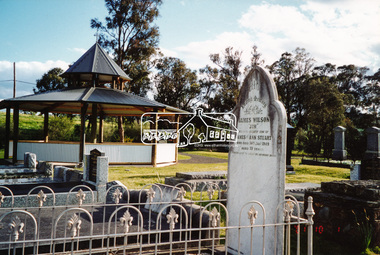
Photograph, A walk through the cemetery at Kangaroo Ground, Diana Bassett-Smith, 1 October 2001, 2001
The Kangaroo Ground Cemetery celebrated its 150th anniversary in 2001. Celebrations included the opening of a new rotunda on the 26 October 2001. Ths photo is a part of a brief collection of reminiscences by Diana Bassett-Smith of locals who are buried at Kangaroo Ground Cemetery along with 17 photographs following a visit on 1 October 2001. "One other headstone, that of James Wilson. It was a Wilson who had a nursery at the North Eastern end of Bourchiers Road on the land known as Tintagell alongside the Yarra. He grew trees, pines in particular, and supplied within the district and to the gardens of Melbourne. According to Jimmy Cook. The last of the warriors is between the gate and the river. And confirmed by Dorrie Bourchier that the original pines to what is now our property came from Wilson. The only one left now is by Passiona. Lightening claimed the one at the corner of our drive." Colour photograph printkangaroo ground cemetery, rotunda, james wilson