Showing 6955 items matching " central"
-
 Bendigo Historical Society Inc.
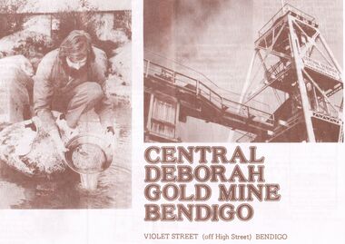
Document - JOAN O'SHEA COLLECTION: CENTRAL DEBORAH GOLD MINE BENDIGO, 26th November, 1984
Joan O'Shea Collection. Central Deborah Gold Mine Bendigo. Promotional material. Chronological History, Poppet legs and shaft, Change Room, Caretakers or rag pickers room, Drying room, first aid room, carbide light room, Underground, carpenters shed, ore bins and loading bays, stamper battery, wilfley table, berdan pans, laboratory, display room, boiler, stroke hold, winding engine, boiler feed pump, electric driven compressor, steam driven compressor, blacksmith's shop.Photograph Courtesy Philip Beer.mining, marketing, central deborah mine. -
 Bendigo Historical Society Inc.
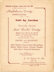
Document - IAN DYETT COLLECTION: AUCTION CATALOGUE - AMPHITHEATRE DREDGE
Auction catalogue with a cream cover and dark red printing for an auction held at the Amphitheatre Dredge, Amphitheatre on 5th and 6th February, 1958 of electrically Operated Steel Bucket Dredge. Lots include Houses and Buildings for Removal, Motor Vehicles, Tractors, Earth Moving Plant, Electric Motors, Pumps, Winches, Valuable Tools, Stores, Piping and Accessories by order of the Central Victoria Dredging Co. N. L. Contains descriptions of sale items and a number of prices have been written in. J. H. Curnow & Son were the Auctioneers.business, auctioneers, j h curnow & son pty ltd, ian dyett collection - auction catalogue - amphitheatre dredge, central victoria dredginh co n l, j h curnow & son pty ltd, prahran telegraph printing co pty ltd -
 Bendigo Historical Society Inc.
Document - Central Deborah Gold Mine Underground Project Opening, 1986
Parry CollectionCentral Deborah Gold Mine Underground Project Opening by Premier John Cain, featuring the City Club Dancers. The program is produced by the Bendigo Trust in conjunction with the City Family Hotel. Program: 1. Acknowledgements of sponsors. 2. The legend of Lady Deborah 3. Awakening of Deborah by the Victorian Police Band 4. Short history of the mine Also included is a gold embossed invitation and its envelope, to Mr and Mrs J. Parry from the Chairman of the Bendigo Trust Mr D. H. R. McLure and Directors.history, bendigo, j s parry collection, central deborah mine opening -
 Tennis Australia
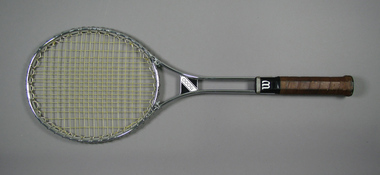
Racquet, Circa 1978
A Wilson 'T5000' metal tennis racquet, with double shaft; metal shaft bridge; black plastic shaft casing featuring 'W' logo and silver whipping. Model name printed on adhesive label fitted to shaft bridge. Handle wrapped with brown leather. Net anchored to metal wire wrapped around head frame. Black plastic butt cap with central hole & adhesive label featuring manufacturer name in silver. Materials: Metal, Plastic, Adhesive tape, Nylon, Adhesive label, Leathertennis -
 Kew Historical Society Inc
Document - Invitation to a Royal Review at Flemington, Sands & McDougall Ltd, 1901
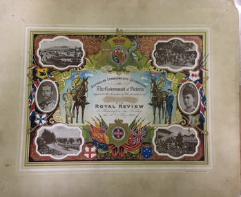
The correspondent of The Argus recorded that: "The Parliament of the Commonwealth was opened yesterday by the Duke, of Cornwall and York, under a Commission signed by Queen Victoria and subsequently endorsed by King Edward VII. The ceremony was marked by the splendour and solemn impressiveness which befitted its historic importance. ... To-day the Heir to the Throne will review some 15,000 Australian troops at Flemington. ... It is a function which, on a lesser scale, might have been arranged at any time for many years past; but it could never previously have conveyed the meaning it does now. Soldiering was popularly regarded as a pastime here until South Africa tried the mettle of our men. It is serious business from henceforth. Those who followed the nascent aspirations of the volunteer soldiery in Australia must be impressed at the rapidity of their fulfillment. ... The document design has artistic and aesthetic merit. While it is not rare, it is representative of the kinds of formal designs used for the Australian Commonwealth celebrations at the time of Federation, and is in excellent condition. Such items as this invitation have local, state and national historic significance as mementoes of a key moment in Australia's history. Locally, the invitation is part of a group of Federation-related items owned and displayed at 'Fairyland' by Mrs Grace Tabulo, and a rare survivor of that collection.An invitation, mounted on card to the Royal Review held at Flemington racecourse on Friday 10 May 1901, as part of the Government of Victoria's Australian Commonwealth Celebrations. The border is vividly decorated with flags, shields and a large coat of arms. The photographic images depict various scenes of Flemington in Melbourne, in addition to two separate portraits of the Duke and Duchess of Cornwall and York. Illustrations of military servicemen on foot and horseback flank the central block of text. The invitation was part of the 'Fairyland Collection assembled by Jim and Grace Tabulo. The name on the certificate was expunged.Printed: AUSTRALIAN COMMONWEALTH CELEBRATIONS/ The Government of Victoria/ requests the honour of the presence of/ [name deleted] / AT THE/ ROYAL REVIEW/ at Flemington on Friday/ the 10th of May 1901. Reverse: Mrs G. Tabulo, 57 Malmsbury St.federation events, royal review - 1901, federation -- invitations, grace tabulo -- fairyland -- 57 malmsbury street -- kew (vic.) -
 Kew Historical Society Inc
Map, MMBW, MMBW Plan No.67 Kew, 1900-1910
The Melbourne and Metropolitan Board of Works (MMBW) was established by an act of the Victorian Parliament in 1890 to prepare for and to implement a sewerage and water reticulation system across what was then inner Melbourne, its surrounding and middle distance suburbs, including Kew. The MMBW was disbanded in 1991.The map collection of the Kew Historical Society has at its core the historic maps assembled and originally stored in the City Engineer's Department of the City of Kew. These include maps in a number of scales. The vast majority of maps were produced by the MMBW in the first two decades of the twentieth century, and are solid working maps, backed by linen for durability. These maps are historically significant to Kew, the City of Boroondara and to the history of the development of state utilities in Victoria. A number of the Kew maps have additional details added by former municipal officers, including the levels reached by various floods. As these were working documents, information was added to them long after the period of their initial production and distribution.Early map of part of the Borough of Kew, created in the first decade of the twentieth century, at a scale 160 ft to 1 inch. The map covers what was then the north central part of Kew, bordered on its north by the Outer Circle Railway Spruzen and Beresford Avenues, in the west by Princess Street, in the south by High Street, and in the east by (about) Belford Road. The map shows the extent of urban development by that time, prominent institutions and the outlines of built structures in the municipality. Contour lines were added in ink to the map at a later stage.MELBOURNE AND METROPOLITAN BOARD OF WORKS / PLAN NO. 67 / KEW melbourne & metropolitan board of works, mmbw maps, mmbw plans, borough of kew, cartography -
 Kew Historical Society Inc
Map, MMBW, MMBW Plan No.68 Kew, 1900-1910
The Melbourne and Metropolitan Board of Works (MMBW) was established by an act of the Victorian Parliament in 1890 to prepare for and to implement a sewerage and water reticulation system across what was then inner Melbourne, its surrounding and middle distance suburbs, including Kew. The MMBW was disbanded in 1991.The map collection of the Kew Historical Society has at its core the historic maps assembled and originally stored in the City Engineer's Department of the City of Kew. These include maps in a number of scales. The vast majority of maps were produced by the MMBW in the first two decades of the twentieth century, and are solid working maps, backed by linen for durability. These maps are historically significant to Kew, the City of Boroondara and to the history of the development of state utilities in Victoria. A number of the Kew maps have additional details added by former municipal officers, including the levels reached by various floods. As these were working documents, information was added to them long after the period of their initial production and distribution.Early map of part of the Borough of Kew, created in the first decade of the twentieth century, at a scale 160 ft to 1 inch. The map covers what was then the north central part of Kew, bordered in the north by Oak Avenue, in the west by the Yarra River and Connor's Creek, in the south by Beresford and Carnegie Avenues, and in the east by Glass's Creek and Burke Road. The map shows the extent of urban development by that time, prominent institutions and the outlines of built structures in the municipality. Contour lines and the levels of historic floods were added in ink to the map at a later stage.MELBOURNE AND METROPOLITAN BOARD OF WORKS / PLAN NO. 68 / KEW melbourne & metropolitan board of works, mmbw maps, mmbw plans, borough of kew, cartography -
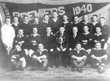 Surrey Hills Historical Society Collection
Photograph, Surrey Hills Church of Christ football team, 1940, 1940
In 1940 The Surrey Hills Church of Christ team played in A Grade of the Eastern Suburbs Protestant Churches Football Association. Other clubs competing that season were: Spring Road Methodist, Glendearg Grove Methodist, Burwood Protestant, St.Marys Church of England, Balwyn United, Box Hill Adelphian and Box Hill United. Alan Sneddon played in the team. The inauguration of the Association took place at a meeting held at Camberwell Methodist School Office on the 19 March 1923. The following churches were represented at this meeting: Auburn Presbyterian, Kew Presbyterian, Hawthorn Presbyterian, Camberwell Methodist, Canterbury Methodist and St Marks Church of England, Burke Road and Holy Trinity Church of England, Surrey Hills. From 1923 to 1992 there were at least 160 clubs / teams that competed through the various grades with many of these combining & /or changing names, as well as those that competed irregularly. Black and white photo of the 1940 Surrey Hills Church of Christ football team with the Eastern Suburbs Football Association premiers flag in the background. The team includes 18 players, an umpire and 3 club officials, the later are centrally seated and one holds the premiership cup.Black and white photo measuring L 20.4 cm x H 15.4 cm mounted on its original presentation folder, which is mounted on card. The photographer's details are beneath the photo on the original mount, partially obscured by the descriptive label. The script is indecipherable.On back of card in Jocelyn Hall's writing: "Have 5 of these studio photos. / One is marked 'ORIGINAL' / ( - safekeeping) / This is Centre copy".churches, espcfa, surrey hills church of christ, football, football clubs, sporting clubs, eastern suburbs protestant churches football association, alan sneddon -
University of Melbourne, Burnley Campus Archives
Plan, School of Primary Agriculture & Horticulture - Burnley, c. 1925-1926
Copy of plan photographed at the Public Records Office Victoria. Central Administration Correspondence Files 1912-1939 ITEM. VPRS 10163/P0003/2. Accomodation Burnley School Part 1. Traced from M.M.B.W. Plan No. 42. Scale 160 ft=1 in. Level Datum L.M.N. Hobson's Bay. Traced by C.E.B.W. 16.02.1926. Additional matter in red and green inserted by F.E.T.C. 09.02.1926. Note by J.J. Rae (Principal). Lists W.C.s (toilets). Shows 1891 Flood Line. Possibly dates from 1925.prov, school of primary agriculture and horticulture, burnely, j.j. rae -
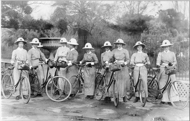 Royal District Nursing Service (now known as Bolton Clarke)
Photograph - Photograph, black and white, 1907
This photograph was taken four years after bicycles were purchased by the Melbourne District Nursing Society (MDNS) and is a record of the first mode of transport used by their Trained nurses, and a record of the change of head ware needed now bicycles were in use. The uniforms were grey with white collar, belt and cuffs and a red Maltese cross was in the centre of the pith helmet. Prior to the use of bicycles the trained nurses walked to their patients and had become exhausted, particularly in summer. The bicycles were a solution to this problem, and now they could visit more patients and the Society's areas (districts) could be extended. In February 1885, 50 years after Melbourne was founded, it was recognized that nursing care was needed for the sick poor in inner Melbourne. The Melbourne District Nursing Society (MDNS), the first such Society in Australia, was founded with one Trained nurse, called 'Nurse' in those days, and a second employed six months later. They worked in the now CBD, ie from Spencer Street to Spring Street and from Victoria Parade to Flinders Street. From its inception the Society was at the forefront of health care. They provided high quality nursing care; educated their patients in the curing and prevention of disease; teaching the importance of cleanliness and good nutrition, both by verbal instruction and demonstration, even supplying soup and milk when needed. At that time they walked the streets and lane ways amid the slums of inner Melbourne carrying their nursing bag containing lotion, ointments, powders, liniment, bandages, dressings, a case of spirits, and the Nurse's own clean apron, soap and small towel. They supplied equipment on loan, such as earthenware hot water bottles, splints, urinals, bed pans, bed cradles, feeding mugs, and air-cushions as well as providing blankets, clean bed linen, and nightdresses as necessary. Trained Midwives began home births in late 1893 taking midwifery bundles and providing clothes for the babe and mother as needed. This was arduous work, particularly in the heat of summer. Permission to use bicycles was given to the Nurses in 1898 and the Society decided to purchase their own in 1903. A business man offered ‘new free wheel’ bicycles at £13 each which included maintenance for one year. Bells and wooden frames were added, at a cost of £5 per frame, so the Nurses could carry extra equipment. Nurses’ bags were strapped to the handlebars. Soup was made for those in need 2-3 times a week and if patients could not arrange to have it collected the soup was delivered by the Nurses on their bicycles. The use of bicycles caused a change in uniform, with white pith helmets, and veils covering them and tied under their chin, now being used. The Nurses provided high quality nursing care to a range of people, often in destitute situations, some lying on rags on the floor as they had no bed, others with just a bed and maybe a thin blanket, a chair and nothing else. Their ages ranged from babes, children, adults to the elderly. The Nurses gave medications as ordered by a Doctor, dressed wounds e.g. to the injured, and surgical cases, and to those with leg ulcers; attended to patients with ‘surgical ailments’ such as ‘hip disease’; gave care to those with acute illnesses such as bronchitis, pleurisy, pneumonia, measles, and scarlet fever, as well as those with chronic illnesses such as consumption (tuberculosis), heart disease, arthritis, cancer, debility, neuritis and paralysis. Over the years the Nurses complained that their veils became wet in the rain and asked for a change of uniform but this did not occur until 1921. Bicycles continued to be used in inner areas until 1945. Black and white photo of a group of ten (one partially hidden at rear) Melbourne District Nursing Society (MDNS) trained nurses, with each standing with their bicycles in front of a spiked metal fence.The Nurses are wearing their MDNS uniform long grey frocks with white collar, cuffs and belt and white pith helmets with a central Maltese cross. Nursing bags are strapped to five of the bicycles. A large pedestal urn is seen to the left behind the fence between the 3rd and 4th nurse. Bushes and trees are seen in the background. melbourne district nursing society, mdns, nurses, uniforms, mdns transport, mdns equipment, rdns, royal district nursing service -
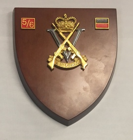 The 5th/6th Battalion Royal Victoria Regiment Historical Collection
Plaque - Presentation Plaque, 5/6 RVR
Presentation plaque made of varnished wood. Located centrally is a large gold and silver Royal Victorian Regiment badge. The badge is made up of crossed gold SLRs a queens crown and a banner with " Victoria" located in front of a large silver "V". Located in the top left corner of the plaque is a 20mm x 15mm gold bordered red square with the numbers "5/6" embossed on it. In the top right is a small 5th battalion Colour patch. This is made up of a black rectangle laying atop of red rectangle.5/6rvr, infantry, plaque, colour patch, hat badge, wark vc club -
City of Kingston
Photograph - Black and white, 17 January 1951
Moorabbin, Cheltenham and Highett are suburbs in the City of Kingston with a diverse mix of development and zoning. This 1954 image shows the market gardens, farms and paddocks of the Moorabbin and Cheltenham area. which have gradually been sub-divided into The Highett Gas Works is visible and Cheltenham Park and Victoria Golf Club.The suburbs of Cheltenham and Moorabbin were originally developed with extensive market gardens. Over time the district has been transformed with the farms and paddocks replaced by housing, factories and shopping centres. The Highett Gas Works on the Nepean Highway was a significant feature of the landscape and has now been demolished. and the site has undergone remediation.Aerial photograph of Cheltenham, Moorabbin and Highett within the City of Kingston. The area depicted in this 1951 aerial view includes Wickham Road, Highett (bottom right), Keys Road, Moorabbin (bottom left), Centre Dandenong Road Cheltenham (top left), Park Road, Cheltenham (top right), Nepean Highway (left section), Graham Road and Middleton Street, Highett (bottom right). Cheltenham Park and Victoria Golf Club are visible. Nepean Highway and the Frankston railway line run centrally through the image.White type: 1416-37 538 RUN239 LENS 5312" MELBOURNE METROPOLITAN 12150 17-1-51 ↆ M539 Black pencil: N [arrow]cheltenham, highett, highett gas works, market gardens -
 Glenelg Shire Council Cultural Collection
Print, Mary Macqueen, Nullabor 1-1-83, 1983
Print Council of Australia Members' Print Commission, 1983Abstracted views of a desert scene. A central road intersects image at a vertical diagonal. Faint outlines of houses and a WaterTower are scattered throughout the image. To the lefthand side a building can be seen with a veranda and several seating areas. To the righthand side there is another building and the numerals '1983' can be seen to the side of it. A railway crossing sign is positioned lower centre, at beginning of road. Kangaroos and trees can also be seen in the image. Dominant colour is a pinky red, with blue accents and grey shadows. Mounted in grey matt, in wooden frame. Front: Nullarbor (lower left of image) (ink) 35/100 (lower left) Nullarbor 1-1-83 (lower centre) Mary Macqueen 83 (lower right) (pencil) Back: (no inscriptions)nullabor, desert scene, female artists, female artist, abstract -
 Glenelg Shire Council Cultural Collection
Artwork, other, Ian Rankin, Low Tide - Cape Grant Area, 1990
Depiction of a beach with large boulders in the foreground. The boulders are covered in lichen and algae, and beach sweeps up towards centre right of image. The central third of painting shows the sea (continuing behind the boulders), depicted in blue with white highlights and dark blue shadows. It is edged in the background by a cliff face (painted in brown and grey). Sky is darker blue at top and lighter blue where it meets the horizon. Mounted in double matt (pale tan on faun) with decorative cut-out border, framed under glass in wooden frame.Front: Rankin '90 (lower right) (white paint) Back: 333 (upper left) (sticker) 1990- (upper left) (pencil). Low tide Cape Grant area September 1990 $350 Pastel Ian Rankin. 46 Hurd St Portland Vic 3305 Phone Portland 231465. Phone 055/231465.cape grant, seascape, beach -
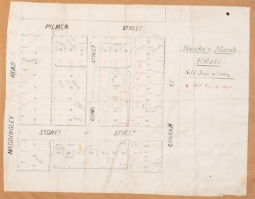 Bacchus Marsh & District Historical Society
Map, Bacchus Marsh Estate sold 30th June 1888 and sold 28 December 1895
Blocks of land in this area of Bacchus Marsh were sold in lots between 1888 and the late 1890s. This map shows sales made in 1888 and 1895.Single page map showing allotments of land bounded by Pilmer Street, Graham Street, Sydney Street and Maddingley Road (Grant Street) in Bacchus Marsh.The area is dissected by Como Street down the central area. 43 blocks of land are shown with the names of buyers or sellers in 1888 written in black in. Buyers or sellers for December 1895 are written in red ink. Part of a set of maps which are pasted into a bound volume containing 76 maps or plans in total. High resolution digital image stored on BMDHS computer network. bacchus marsh victoria maps, land sales bacchus marsh, pilmer street bacchus marsh, graham street bacchus marsh, sydney street bacchus marsh, como street bacchus marsh, maddingley road bacchus marsh, grant street bacchus marsh -
 Linton and District Historical Society Inc
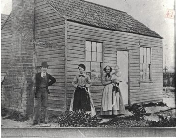
Photograph, Miner's Cottage, Woady Yaloak District
Black and white copy of original photograph which shows a timber cottage with two windows at the front, one each side of a fairly narrow central door. The house has no awning or verandah. It has a shingle roof, and a chimney on one side. A man, two women and a child are outside the front of the house. The man is wearing a waistcoat, tie, jacket and bowler hat, and he is holding a clarinet. The two women are wearing aprons and one of them is holding the child. The location of the house, date of the photograph and the identities of the people in it are unknown.Typed on a piece of paper attached to back of the photograph: "Early wooden miner's cottage, Woady Yaloak District".buildings, houses -
 Glenelg Shire Council Cultural Collection
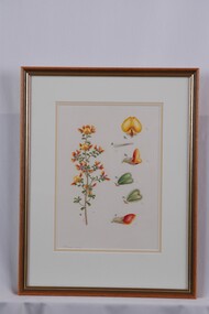
Drawing - Drawing, Botanical, Pultenaea Scabra (Rough Bush-Pea), n.d
Part of 'Woolcock Gallery Collection' Exhibited CEMA 1989.Drawings of a flowering plant stem with flower details. On left is a flowering stem, with a woody central stem, small heart-shaped leaves and yellow and orange pea flowers. To right are studies of leaves and flowers: (t-b) top view of flower (yellow); flower detail; side view of flower; top and underside views of leaves; side view of bud. Each view is labelled in pencil and in typed letters affixed to paper. Mounted in double matt (white on faun) in glazed wooden frame with gold detail.Front: Pultenaea scabra (lower left) (pencil) Back: 30 (upper left) (pen)collin woolcock, botanical, woolcock collection, cema, botanical drawings -
 Ballarat Tramway Museum
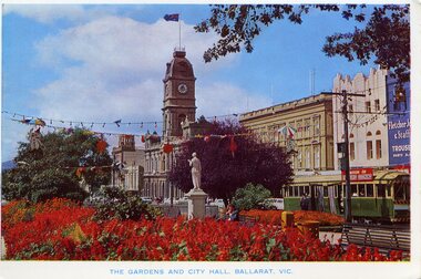
Postcard, Rose Stereograph Co, "The Gardens and City Hall. Ballarat Vic.", mid 1960's
Has a strong association with the Rose Stereograph Co, demonstrates the gardens displays in Ballarat c1960's and yields information about the streetscape at the time.Colour postcard print of the central median gardens, Sturt St, with the Town Hall in the background and bogie tram No. 37 on the South Side. Has festoon lighting and other street decorations (Begonia Festival?) in the view. In the background are Myers, the Town Hall and Fletcher Jones store. No. 37 has the destination of Sebastopol and a "Switch to Electric Cooking" roof advertisement. Title "The Gardens and City Hall. Ballarat Vic." Postcard - Rose Series Colorview No. 509. On rear is the rose of Rose Stereograph Co and information. Duplicate of Reg Item - 1025On reverse side - black ink stamp "E.G.Butland"trams, tramways, town hall, gardens, sturt st, begonia festival, tram 37 -
Bendigo Historical Society Inc.
Letter - MCCOLL, RANKIN AND STANISTREET COLLECTION:CAMERON SUTHERLAND SEWARD TO STANISTREET ESQ
Letter Cameron Sutherland Seward Pty Ltd., 26 May 1931 to J.J.Stanistreet Esq, Commonwealth Bank Buildings, Charing Cross, Bendigo re quotes from Mr. Bloomfield 'in connection with the Deborah, Monument Hill and Central Nell Gwynne Mines. Deborah Mine: horizontal steam driven air compressor, air receiver - price 45 pounds. Steam mining winches, Cornish boiler, Lancashire Jackass boiler, Cornish Flue Boiler (Roberts) funnels for boilers, exhaust tanks, quartz hoppers, poppet heads.bendigo, gold mining, mccoll rankin and stanistreet, bendigo, monument hill gold mine, deborah gold mine, central nell gwynne gold mine, g. seward, j.j. stanistreet, cameron, sutherland and seward pty ltd. -
 Bendigo Historical Society Inc.
Document - WINDMILL HILL - PRODUCTION STATISTICS
Handwritten copy of production statistics from Windmill Hill. Some of the Miners were: Sullivan and his sons, Lindsay and Taylor, Thorpe & Co and Mr Lansell. The mines mentioned are: Confidence Lease, Central Windmill, Cinderella Claim,Confidence Extended, Extended Hustlers, Carlisle, Garden Gully, Johnsons Reef, United Hustlers & Redan, North Johnsons and United Devonshire. Also a piece of paper (b) with Johnsons Group See Annals of Bendigo 1872. Page 140. Document from Albert Richardson Collection of mining history.gold, windmill hill, windmill hill, production statistics, sullivan and his sons, lindsay and taylor, thorpe & co and mr lansell, confidence lease, central windmill, cinderella claim, confidence extended, extended hustlers, carlisle, garden gully, johnsons reef, united hustlers & redan, north johnsons and united devonshire. a m s special edition 1/6/1899 page 47, annals of bendigo 1872 page 140, albert richardson -
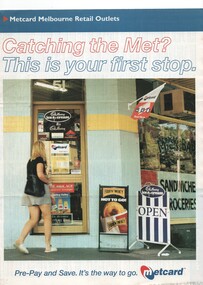 Melbourne Tram Museum
Pamphlet, VicTrip, "Catching the Met? - This is your first stop.", Apr. 1999
Pamphlet - four fold - special size - full colour titled "Catching the Met? - This is your first stop." giving the list of Metcard shops in central and suburban Melbourne, along with maps of the tram and train systems. The maps show both Yarra and Swanston trams with route numbers along with Bayside and Hillside trains and the various ticket zones at the time. The number of car parking spots at each station also shown. On the rear is general information about Metcard with ticket machines, and validators. List dated effective from April 1999.trams, tramways, maps, metcard, yarra trams, swanston trams, hillside trains, bayside trains, tickets -
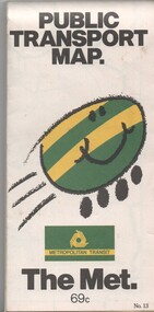 Melbourne Tram Museum
Map, Metropolitan Transit Authority (MTA), "Public Transport Map", c1984
Fold out map (36 sections 9 across x 4 deep), "Public Transport Map", coloured of Melbourne's Tram and Bus routes, route numbers, rail lines, detailed for the central part of Melbourne and the outer Metropolitan services. Includes description of tram and bus routes, private bus routes. On the front cover is The Met's Buzz symbol and their logo. Has contact details for bookings and lost property etc and how to use the map. Priced at 69c, issue No. 13 of c1984. Two copies held.trams, tramways, melbourne, map, tram & bus services, railways, the met, neighbourhood tickets -
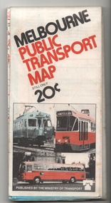 Melbourne Tram Museum
Map, Ministry of Transport, "Melbourne Public Transport Map", c1977
Fold out map (27 sections 9 across x 3 deep), coloured of Melbourne's Tram and Bus routes, route numbers, rail lines, detailed for the central part of Melbourne and insert section for Frankston. On rear description of routes, private bus routes and map of Melbourne metro lines. Has contact details for bookings and lost property etc. Priced 20c Dated 1977, says No. 6 on bottom of rear cover. Note shows route 59 being cut back to the highway.trams, tramways, melbourne, map, tram & bus services, railways, mmtb, minister for transport -
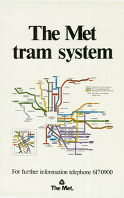 Melbourne Tram Museum
Poster, The Met, "The Met Tram System", mid 1990's
Poster - full colour on semi gloss paper titled "The Met Tram System" showing in a diagrammatic form the Melbourne tram routes, major street names, route numbers, principal suburbs, terminal names, central area (pre Docklands, post light rail to St Kilda and Port Melbourne) and ticket zones. Has The Met logo and the Public Transport Corporation names on the bottom. Mid 1990's, Batman Ave still shown. 2nd copy added 2-2-2019 and scanned, replaced image file.trams, tramways, melbourne, tramways, tram routes, map, posters -
 Bendigo Historical Society Inc.
Document - VICTORIA HILL - VICTORIA HILL HISTORY
Hand written notes and typed copy of the history of Victoria Hill area. Some of the mines from South to North: North Old Chum, Lansell's 'Big 180', Ballerstedt's Open - Cut, 20 Head Battery Stampers, The Victoria Quartz, Rae's Open - Cut, which has some colourful geographical features, Central Victoria (also known as the 'Midway'), Wittshiebe's 'Jeweller's Shop', Boldt's 5 Head Crushing Battery (site only), Advance Shaft, Hercules & Energetic. Notes prepared by Albert Richardson.mine, gold, victoria hill, victoria hill, victoria hill history, north old chum, john wybrandt, lansell's 'bit 180', t ballerstedt, wittschiebe, fortuna villa, geo lansell, a h q survey regiment, ballerstedt's open cut, victoria quartz (victoria reef quartz), rae's open cut, wm rae, gt central victoria (midway), adventure, wittshiebe's 'jeweller's shop', boldt's 5 head crushing battery, advance, cinderella, hercules & energetic, john brown knitwear factory, a richardson -
 Bacchus Marsh & District Historical Society
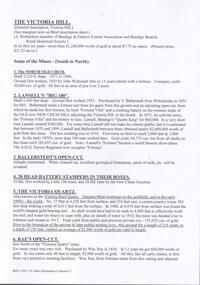
Photograph, Bacchus Marsh Rifle Club members 1883
A Rifle Association was formed in Bacchus Marsh in April 1868. In 1882 this Association was reformed as the Bacchus Marsh Rifle Club and given the number 4. This photograph was taken at the first range used by the club which was near the old Woolpack Inn on the Melbourne to Ballarat Road. Rifle Club members in this image are known to include, W. H. McFarlane, F. Lewin, W. Marshall, T. Heath, E. A. Jones, W. Meikle, J. Dodemaide, D. Murray, W. H. McFarlane Jnr., J. Young, W. Mahoney, W, Rae. The Bacchus Marsh Express newspaper of 6 October 1883 reported that this image was taken during a married versus single match on the 3rd October, 1883. The match was interrupted to allow the photograph to be taken. This resulted in the match finishing in the dusk with the win going to the married team. This image is one of a series of photographs taken by Melbourne based photographers Stevenson and McNicoll who visited Bacchus Marsh and its nearby districts between September and November 1883. Black and white photographic print copy of original sepia 'carte de visite' style unframed photograph on card with gold border framing photograph. Part of the original inscription can be seen on the front left side of the photograph, which is one of a set of images taken in and around Bacchus Marsh in 1883 by the photographers Stevenson and McNicoll. The image shows a group of nineteen men holding rifles standing on either side of a white target board, the central bullseye showing a number of hits. All are posed against a backdrop of hills.Printed On the front: Stevenson & McNicoll. Photo. 108 Elizabeth St. Melbourne. COPIES CAN BE OBTAINED AT ANY TIME. stevenson and mcnicoll 1883 photographs of bacchus marsh and district, bacchus marsh rifle club, rifle clubs -
 Linton and District Historical Society Inc
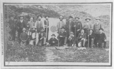
Photograph, R.S. Nelson, Grocers, Ironmongers
This image shows the undertaker's premises/general store run by R. S. Nelson (Snr.) from the early 1860s and is thought to have been taken in the 1880s. This building was modified considerably by successive generations of the Nelson family over the years (see Registration nos. 338, 2019-314, 2019-320, 2019-325, and photos on p.33 & p.34 of the 'Photographic History''). It is currently used as the LDHS Resource Centre. The people standing at the front of the shop are unidentified. This image was copied in 2020 from a facebook post by Marcia Penny, a descendant of Linton's Craine family. Information with the image on facebook said the original photograph had been in a McIntyre family album (the McIntyre family was connected to the Craine family by marriage).Digital copy of an original photograph and its mounting card. The photograph shows a group of eight men and three children standing beneath the verandah of a shop. A sign above the verandah reads "R.S. Nelson & Son / China and Paint / Glass, Oils", and lettering across the verandah reads "Grocers Ironmongers &c". The shop front has a central doorway, and two large windows, each with twelve wood-framed, square panes of glass. Three posts support the verandah. Above the doorway of the shop, lettering reads "Furnishing Undertakers".r. s. nelson (1833-1893), buildings, shops, undertakers -
 Bendigo Historical Society Inc.
Document - NEW CHUM LINE OF REEF - GOLD PRODUCTION ON THE NEW CHUM LINE OF REEF
Handwritten page containing the names of mines and the number of ounces of gold they produced. Mines mentioned are: Lansell's 222, Lazarus New Chum, Old Chum, New Chum & Victoria, North Old Chum, Lansell's Big 180, Victoria Quartz, Gt Central Victoria, Victoria Consols, South Adventure Group, Adventure, Advance, Try - Me - Well, Prince Alfred, Alfred Co, Lansell's 83 and Ironbark (no production figures). Note beside Alfred & Co - Land pegged by J R Evans in 1857.document, gold, new chum line of reef, gold production on the new chum line of reef, lansell's 222, lazarus new chum, old chum, new chum & victoria, north old chum, lansell's big 180, victoria quartz, gt central victoria, victoria consols, south adventure group, adventure, advance, try - me - well, prince alfred, alfred co, lansell's 83, ironbark, j r evans -
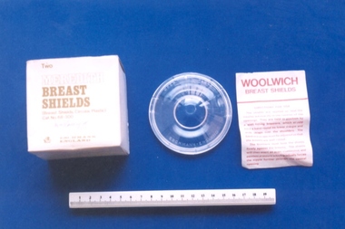 Royal Australian and New Zealand College of Obstetricians & Gynaecologists (RANZCOG)
Meredith nipple shields associated with Dr Ronald McKenzie Rome, Eschmann, England
These were intended for use during pregancy, worn as an aid for the correction of inverted or depressed nipples. Nipple shields will help some babies attach to the breasts, that are otherwise unable to. Shields are made of a fine, silicone material that sits over the areola and nipple. (Source: Mater Mother's Hospital, 'Engorgement and Breast milk Oversupply')Two nipple shields with original cardboard box and leaflet. Each nipple shield is plastic and consists of two parts which are separated by turning the top part anti-clockwise. The bottom part of each shield has a central opening 3cm in diameter. Box is cube shaped with olive green writing. Instruction leaflet is printed in red. Text imprinted on shields reads "OPEN [two way arrow] CLOSE"/"ESCHMANN ENGLAND". Text on lid reads "Two/MEREDITH/BREAST/SHIELDS" with some specifications.breast feeding -
 Bendigo Historical Society Inc.
Document - MCCOLL, RANKIN AND STANISTREET COLLECTION: DIVIDENDS AND SHAREBROKERS, 10th July, 1977
6 page handwritten document. Front page ' List of Directors and Sharebrokers' List of mines. Pages 2 and 3 - list of sharebrokers in Victoria. Page 4 - list of dividends (25th) to Monument Hill Consolidated. Page 5 - dividend Information for North Deborah, Central Nell Gwynne, Monument Hill Consolidated. Quartz Block Mine. Notes re mines are andwritten on back of Bendigo Historical Society typed documents - 'Musicale, July 10th. 1977 at Dudley House. (scrap paper?) Possibly written by Albert Richardson.mccoll rankin & stanistreet, shareholders report