Showing 9613 items
matching water-rates
-
 Wodonga & District Historical Society Inc
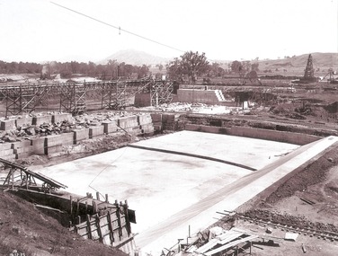
Album - Hume Reservoir Australia Album - Stilling pool opposite outlet section of dam, December 1925
This set of photos is from a leather bound album bearing the inscription "HUME RESERVOIR AUSTRALIA" plus 'The Rt. Hon. L. C. M. S. Amery, P. C., M .P.' all inscribed in gold. It was presented to The Rt. Hon. L. C. M. S. Amery, P. C., M. P, Secretary of State for Dominion Affairs on the occasion of his visit to the Hume Reservoir on 2nd November 1927. This album is of local and national significance as it documents the planning and development of the Hume Reservoir up to 1927. It was the largest water reservoir in the British Empire. The album records the pioneering engineering work that went into its construction.DEPARTMENT OF PUBLIC WORKS, N.S.W. RIVER MURRAY WATERS SCHEME. HUME RESERVOIR. 18. Stilling pool opposite outlet section of dam. New South Wales. December 1925 A stilling pool is a structure at the downstream side of a dam, designed to take away some of the energy from overtopping water flowing down the spillway, to reduce the risk of erosion of the ground near the dam and the dam itself.hume reservoir australia, river murray waters scheme, hume reservoir construction -
 Glenelg Shire Council Cultural Collection
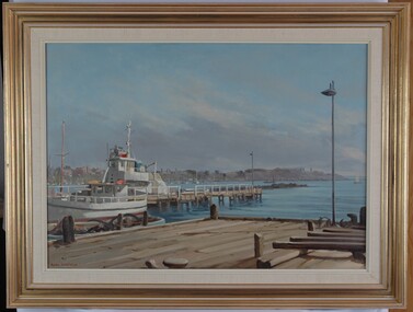
Painting, Whalers Point from Harbour Trust Dock, n.d
Port of Portland CollectionView of harbour and jetties from a dock. Dock is in foreground. A white fishing vessel is berthed at a jetty positioned near the dock. In background is a view of the foreshore with buildings. The water is pale blue with darker blue details. The sky is blue with grey wash depicting clouds near horizon line. Mounted in thick cream canvas mount, framed under glass in wooden gold painted frame.Front: Signature - Ramon Horsfield (lower left) (orange paint). Back: (no inscription)port of portland -
 Glenelg Shire Council Cultural Collection
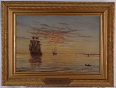
Painting, Port Phillip Bay (Sunset), n.d
UnknownScene of two sailing ships on a harbour at sunset. The ship on the left is in full sail, the ship on the right has furled sails. At front left is a flock of gulls and on front right is a figure in a row boat. At centre right is coastline with structures and several small boats. The sky has clouds reflecting the sunset in pink, yellow and indigo. These colours are reflected on the surface of the water. Framed in gilded wooden frame.Front: A.S. Murray (lower left) Port Phillip Bay (Sunset) (brass plate, l. centre of frame) Back: (no inscriptions) Conservation Centre, Melb. label.sea, seascape, maritime, sailing ships, sailing -
 Bendigo Historical Society Inc.
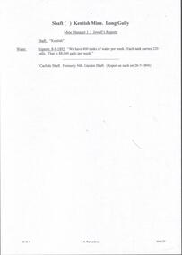
Document - MINING REPORTS - KENTISH MINE MANAGER'S REPORT
Here on the Garden Gully Line were Bell and Watson’s, the Cornish United, the Victory and George Lansell’s pride, the Pandora. Here too, was the enormously rich Kentish Mine from which its owner, J.B.Watson, was credited with taking some thirteen tons of gold, then worth £1,500,000. At this time, John Boyd Watson was well on the way to becoming not only the richest man in Sandhurst, but probably in the colony. (Extract from North West Victoria Historic Mine Sites, David Bannear, Heritage Victoria, 1991.)Handwritten extracts by Albert Richardson, with typed copy of same, from the Kentish Mine Manager, J. J. Jewell's Report. Extracts dated 1-11-1894 and 9-3-1894. Report mentions crushings and gold yield at the Old Carlisle Shaft and crushings and gold yield from The 'Central' mullock. (b) mentions the baling of water and the Carlisle Shaft, formerly Nth Garden Shaft.document, gold, mining reports, mining reports, kentish mine manager's report, j j jewell, old carlisle shaft, w griffiths & party, nth garden shaft, j cock & party, the 'central' -
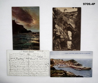 Bendigo Military Museum
Postcard - PHOTGRAPHIC POSTCARDS WW1, unknown
Items in the collection relating to C.J.C. McQuie MM, refer Cat No 9680P for his service details. All the cards are not complete sets sent. The writing is McQuie's. .1) At the top hand written is (2) in purple, page talks about Sept 5th, hospital & letters. .2) At the top hand written is (3) in purple, page talks about leave. .3).4) At the top hand written is (3) & (4) on respective cards, one follows the other in text, talks about being on leave and having a large collection of prints.Four Postcards undated, none addressed to or signed off. .1) Colour enhanced, Ilfracombe at sunset, text on the rear in purple, full page. .2) Sepia tone, Water Mouth, Briary, text on rear in purple, full page. .3) Colour enhanced, Ilfracombe, text on rear in black, full page. .4) Colour enhanced, Ilfracombe, text on rear in black, full page.postcards, photos, mcquie -
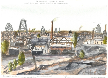 Bendigo Historical Society Inc.
Artwork - JOHN HALL COLLECTION: WATER COLOUR PAINTING: DUCHESS TRIBUTE MINE CALIFORNIA GULLY, 2013
JOHN HALL COLLECTION: Original WATER COLOUR PAINTING: Duchess Tribute Mine California Gully. Signed in bottom LH corner by John Hall. Dated 2013. Written in pencil at top Devonshire group of Mines. Snob's Hill and Mungo Mines in the background. Written on bottom edge Duchess Tribute, South Devonshire West United Devonshire, Phoenix, Duchess of Edinburgh, United Devonshire.John Hallartwork, water colour, gold mines -
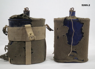 Bendigo Military Museum
Equipment - WATER BOTTLES
Equipment issued to all Army Soldiers as part of original kit. Kit belong to CAPTAIN Brian CLEREHAN VX91862. Enlisted 29 March 1943 age 26 years, discharged 17 July 1946 with the rank of Captain in 2nd New Guinea Infantry Battalion..1) One litre water bottle with cork lid, insulating felt cover. Cork attaches by string to the felt cover. And also in a cotton webbing carrier. Made up of vertical and horizontal straps wth a brass studs, 2 brass buckles to attach to shoulder straps .2) One litre blue enamelled bottle with attached cork lid and insulating felt cover. No webbing included .infantry, water bottle, 2nd new guinea infantry battalion -
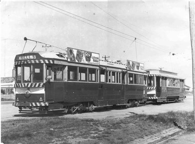 Ballarat Tramway Museum
Photograph - Black & White Photograph/s - set of 2, John Phillips, late 1960's
Black and White photograph of No. 41 and 21 at the Sebastopol terminus. No. 41 has the destination of "Bell St" (shown for the photographer?) and two Johnnie Walker roof advertisements. Photo taken late 1960's. Believed that the print and photo by John Phillips. .1 - Display copy mounted on heavy cardboard, with remnants of Velcro strips on the back, minor water damage, sticky tape from use. tramways, trams, sebastopol, tram 41, tram 21 -
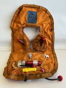 Moorabbin Air Museum
Clothing (item) - Qantas Life Jacket
Rear is inscribed with BACK/Derriere MK 8C/1 Patent No. 889158 9/70 SN279 -
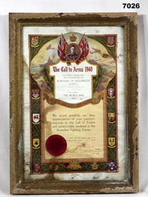 Bendigo Military Museum
Certificate - BOROUGH OF INGLEWOOD, FRAMED, Borough of Inglewood, 1940's
Keith Edwin Palmer V65246 enlisted in B Coy 38th Bn CMF on 17.3.1941 age 24years. Discharged rom the Army on 11.6.1945 with the rank of Sergeant. Certificate - paper, red and black print, illustrated in colour with scroll work, foliage, flags, King's Portrait. Shields of various countries and states and red seal. Damaged by water and dirt. Handwritten owner's name and signature on Certificate. Frame - timber, with gold colour stipple finish, many sections of paint missing. Glass front and cardboard backing. Sections of the certificate are adhered to the glass front.Handwritten in very faded black ink; "Sgt Keith Edwin Palmer/ 38th Battalion" "16th/ November/ 5/ E.E. Rochester" illegible signature. Certificate No. 55255.ww2, certificates, framed accessories -
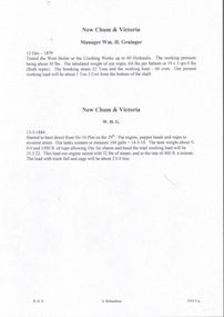 Bendigo Historical Society Inc.
Document - NEW CHUM & VICTORIA LINES OF REEF - NEW CHUM & VICTORIA MINE MANAGER'S REPORTS
Handwritten copies of four Mine Manager's reports for the New Chum & Victoria dated 13/12/1879, Manager Wm H Grainger, 13/3/1884, Manager W. H. G., 15/3/1886, and 21 /6/1886. Reports mention equipment, costs, and a new Winding Plant where they hauled water before allowing the men to descend. Notes on testing boilers.document, gold, new chum & victoria lines of reef, new chum & victoria mine manager's reports, wm h grainger -
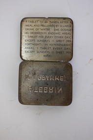 Dandenong/Cranbourne RSL Sub Branch
Atebrin Container
Atebrin was an anti-malarial supplied to Australian forces for use in tropical areas in WWII and Vietnam.This tin is representative of the experience of Australian service personnel serving in tropical areas throughout the 20th Century.Small green rectangular tin container. Embossed writing on the bottom. Hinged lid. Text inside the lid explaining the use of the contents. The tin is empty.ATEBRIN / (0.1 GRAMME) Tablet to be taken after a meal and followed by a large drink of water. The dosage (as ordered) in endemic areas, 1 tablet for every other day, except sundays (1 sheet per fortnight); in hyperendemic areas, 1 tablet every day, except sundays (1 sheet per week).malaria, atebrin, wwii, vietnam, medicine, treatment, tropical, new guinea, aif -
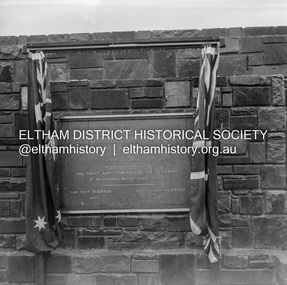
 Eltham District Historical Society Inc
Negative - Photograph, J.A. McDonald, Upper Yarra Dam, 26 Nov. 1957
Upper Yarra Reservoir Opened by His Excellency The Governor of Victoria General Sir Dallas Brooks K.C.B.., K.C.M.G., K.C.V.O., D.S.O., K.St.J. On 26th November, 1957 This tablet also commemortyaes the centenary Of Melbourne's water supply system Yan Yean Reservoir 1857 Upper Yarra Reservoir 1957Record of various Shire of Eltham infrastructure works undertaken during the period of 1952-1962 involving bridge and road reconstruction projects, sometimes with Eltham Shire Council Project Reference numbers quoted. It was during this period that a number of significant improvements were made to roads and new bridges constructed within the shire that remain in place as of present day (2022). In many situations, the photos provide a tangible visible record of infrastructure that existed throughout the early days of the Shire. The album was put together by or under the direction of the Shire Engineer, J.A. McDonald.infrastructure, shire of eltham, 1957-11-26, opening ceremony, plaques, sir dallas brooks, upper yarra dam, upper yarra reservoir -
 Eltham District Historical Society Inc
Negative - Photograph, J.A. McDonald, Upper Yarra Dam, 26 Nov. 1957
Upper Yarra Reservoir Opened by His Excellency The Governor of Victoria General Sir Dallas Brooks K.C.B.., K.C.M.G., K.C.V.O., D.S.O., K.St.J. On 26th November, 1957 This tablet also commemortyaes the centenary Of Melbourne's water supply system Yan Yean Reservoir 1857 Upper Yarra Reservoir 1957Record of various Shire of Eltham infrastructure works undertaken during the period of 1952-1962 involving bridge and road reconstruction projects, sometimes with Eltham Shire Council Project Reference numbers quoted. It was during this period that a number of significant improvements were made to roads and new bridges constructed within the shire that remain in place as of present day (2022). In many situations, the photos provide a tangible visible record of infrastructure that existed throughout the early days of the Shire. The album was put together by or under the direction of the Shire Engineer, J.A. McDonald.infrastructure, shire of eltham, 1957-11-26, opening ceremony, plaques, upper yarra dam, upper yarra reservoir -
 Greensborough Historical Society
Report, Examining Draughtsman's Report - Watts River Aqueduct, 20/07/1897
This Field Survey was commissioned by the Melbourne Board of Works and was used to position the Maroondah Aqueduct bridge north of Greensborough at its crossing point on the Plenty River. It incorporated the use of wrought iron water pipes and therefore is of lighter construction than other similar bridges in the district. It features a traverse of the Plenty RiverThe Maroondah Aqueduct bridge is a significant example of late 19th century engineering. A 4 page reproduction of an Office of Titles document. Copy of handwritten report includes maps.maroondah aqueduct, watts river aqueduct, bridge, greensborough, office of titles, 1897, wrought iron water pipes, plenty river, melbourne board of works -
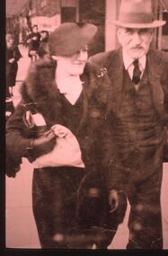 Halls Gap & Grampians Historical Society
Photograph - Transparency, 1920-1930s
Thomas Morgan and his daughter Nina(Mangel). The Morgan Family purchased Killarney/Grampian House in 1927. Thomas,his wife Sylvia and four children- John,Thomas,Dorothy and Nina ran Grampian House. It was the first guest house in Halls Gap to offer hot and cold running water.A street photographer's photo showing a lady dressed in a fur stole and a suit, she is also wearing a hat, and a man dressed in a three piece suit wearing a hatpeople, morgan -
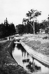 Eltham District Historical Society Inc
Photograph, Tom Prior, Maroondah Aqueduct, Research, Vic, c.1895
Built for opening in 1891 to take water from Maroondah to Reservoir. Part of a slide show presentation "Bridges & Waterways of the Shire" by Russell Yeoman to the 13 September 1989 Society meeting. The presentation included slides of historic photos from the Shire of Eltham Pioneers collections as well as several recent views.This photo forms part of a collection of photographs gathered by the Shire of Eltham for their centenary project book,"Pioneers and Painters: 100 years of the Shire of Eltham" by Alan Marshall (1971). The collection of over 500 images is held in partnership between Eltham District Historical Society and Yarra Plenty Regional Library (Eltham Library) and is now formally known as the 'The Shire of Eltham Pioneers Photograph Collection.' It is significant in being the first community sourced collection representing the places and people of the Shire's first one hundred years. The Reynolds family were early settlers in Research. The Reynolds/ Prior collection of photographs were taken by Tom Prior, the maternal uncle of Ivy Reynolds, around 1900 and the 60 photos in the album give a fine overview of many of the landmarks of Research and Eltham over 100 years ago. lvy lived in the family home for many years at 106 Thompson Cres Research. Ivy's father, Ernst Richard Reynolds and grandfather, Richard Reynolds, lived at the same address. Ivy's father Richard worked for Mr. Trail on his property in Research. Reynolds Road is named after the family. Mr Tom Prior (wife Eva) worked at the Melbourne zoo. He was very innovative and made his own camera, using the black cloth hood to exclude the light. The photographs are a reminder of the rural nature of Research and Eltham and its rich heritage.Digital image (Neg copy missing)shire of eltham pioneers photograph collection, research (vic.), maroondah aqueduct, aqueduct, reynolds prior collection -
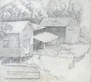 Federation University Historical Collection
Artwork: Sketch Books, David Alexander, Dr: Ballarat, 1971 to 2012
David Acrum Alexander was born c1925 and died in 2015. He practiced medicine in Ballarat but also had a keen interest in sketching and painting. The 52 books range from 1971 to 2012. They include rough outlines for characters, often with a comment re changes to be made. If a pencil sketch or water colour 52 artist's sketch books of varying sizes, spiral bound. Some are thematic in content; characters from novels, places, people Some comments are written and names of peopleDate of work written on covers and on some individual pages. Place name and those of characters from novels.david alexander, sketchbook, artists sketchbook -
 Bendigo Historical Society Inc.
Booklet - Axe Creek Rural Fire Brigade - 75th Anniversary 1912-1987, 1987
The Axe Creek Bush Fire Brigade was formed in 1912 with each landowner contributing 1/- per year. By 1920 the brigade had amassed equipment consisting of rakes, brooms, a 100 gallon water tank and a hand pump. In 1948 it's name changed to the Axe Creek Rural Fire Brigade.20-page soft blue cover booklet with logo on front cover. 'Axe Creek Rural Fire Brigade - 75th Anniversary 1912-1987 Printed by Sloans Printery, Bendigo and Published by the Axe Creek R.F.B. Committee. History of the Fire Brigade illustrated with B&W photos. Handwritten in ink on page 1 'Regards Craig Houlahan' and on page2 'Regards W Houlahan'axe creek, rural fire brigade -
Port Melbourne Historical & Preservation Society
Plan - Proposed Bayside development, Sep 1987
SCDC plans for the Bayside development were revised as investigations into water circulation in artifical canals/harbour were completed. This is the altered plan, with alterations drawn in red on the original proposal, for the EES hearing in September 1987. The EES hearing, scheduled for three days in September, ran for 57 sessions into February 1988.Large plan of original proposed Bayside development as submitted to council in 1987; as 502.01 but with alterations superimposed in red, It was this altered plan that was submitted at the enquiry into the Environmental Effects Statement in September.In blue: EES Variation September 1987:In red: markings to indicate alterations to land configurationtown planning - proposals shelved - bayside, sandridge city development co pty ltd, scdc -
 St Kilda Historical Society
Photograph - Photo map, 28/01/1951
One of a series of photo-maps produced for the Department of Crown Lands and Survey (1857-1983). For correlation with a current map, and access to other historical photo maps of Victoria, see the Historic Photo-Maps Index published by the Department of Environment, Land, Water and Planning at https://services.land.vic.gov.au/DELWPmaps/historical-photomaps/Black and white aerial photograph1424-45 SECRET 534 Run 18 Lens 12" Melbourne Metropolitan 12150 28.1.51 M639albert park, st kilda junction, st kilda pier, catani gardens, st kilda, prahran, albert park lake, 1951, middle park, st kilda beach, windsor -
 St Kilda Historical Society
Photograph - Photo map, 17/01/1951
One of a series of photo-maps produced for the Department of Crown Lands and Survey (1857-1983). For correlation with a current map, and access to other historical photo maps of Victoria, see the Historic Photo-Maps Index published by the Department of Environment, Land, Water and Planning at https://services.land.vic.gov.au/DELWPmaps/historical-photomaps/Black and white aerial photograph1414-21 538 Run 19 Lens 12" Melbourne Metropolitan 12150 17.1.51 M586st kilda, st kilda botanical gardens, peanut farm, elwood, 1951, point ormond, elwood canal, st kilda beach -
 St Kilda Historical Society
Photograph - Photo map, 28/01/1951
One of a series of photo-maps produced for the Department of Crown Lands and Survey (1857-1983). For correlation with a current map, and access to other historical photo maps of Victoria, see the Historic Photo-Maps Index published by the Department of Environment, Land, Water and Planning at https://services.land.vic.gov.au/DELWPmaps/historical-photomaps/Black and white aerial photograph1424-118 534 Run 20 Lens 12" Melbourne Metropolitan 12150 18.1.51M639elwood, point ormond, elwood park, elsternwick park, elwood beach, 1951 -
 St Kilda Historical Society
Photograph - Photo map, 17/01/1951
One of a series of photo-maps produced for the Department of Crown Lands and Survey (1857-1983). For correlation with a current map, and access to other historical photo maps of Victoria, see the Historic Photo-Maps Index published by the Department of Environment, Land, Water and Planning at https://services.land.vic.gov.au/DELWPmaps/historical-photomaps/Black and white aerial photograph1414-20 538 Run 19 Lens 12" Melbourne Metropolitan 12150 17.1.51 M586elwood, elsternwick, st kilda east, balaclava, ripponlea, 1951 -
 St Kilda Historical Society
Photograph - Photo map, 28/01/1951
One of a series of photo-maps produced for the Department of Crown Lands and Survey (1857-1983). For correlation with a current map, and access to other historical photo maps of Victoria, see the Historic Photo-Maps Index published by the Department of Environment, Land, Water and Planning at https://services.land.vic.gov.au/DELWPmaps/historical-photomaps/Black and white aerial photograph1424-44 534 Run 18 Lens 12" Melbourne Metropolitan 12150 28.1.51 M639 -
 St Kilda Historical Society
Photograph - Photo map, 28/01/1951
One of a series of photo-maps produced for the Department of Crown Lands and Survey (1857-1983). For correlation with a current map, and access to other historical photo maps of Victoria, see the Historic Photo-Maps Index published by the Department of Environment, Land, Water and Planning at https://services.land.vic.gov.au/DELWPmaps/historical-photomaps/Black and white aerial photograph1424-43 534 Run 18 Lens 12" Melbourne Metropolitan 12150 28.1.51 M639armadale, malvern, st kilda cemetery, caulfield north, st kilda east, 1951 -
 St Kilda Historical Society
Photograph - Photo map, 30/01/1960
One of a series of photo-maps produced for the Department of Crown Lands and Survey (1857-1983). For correlation with a current map, and access to other historical photo maps of Victoria, see the Historic Photo-Maps Index published by the Department of Environment, Land, Water and Planning at https://services.land.vic.gov.au/DELWPmaps/historical-photomaps/Black and white aerial photographVic 1093-62 Melbourne & Metropolitan Project Run 21 30.1.60 Lens 10" 8.200middle park, albert park, catani gardens, st kilda west, 1960 -
 St Kilda Historical Society
Photograph - Photo map, 30/01/1960
One of a series of photo-maps produced for the Department of Crown Lands and Survey (1857-1983). For correlation with a current map, and access to other historical photo maps of Victoria, see the Historic Photo-Maps Index published by the Department of Environment, Land, Water and Planning at https://services.land.vic.gov.au/DELWPmaps/historical-photomaps/Black and white aerial photographVic 1093-60 Melbourne & Metropolitan Project Run 21 30.1.60 Lens 10" 8.200st kilda, albert park, prahran, windsor, south yarra, 1960 -
 St Kilda Historical Society
Photograph - Photo map, 30/01/1960
One of a series of photo-maps produced for the Department of Crown Lands and Survey (1857-1983). For correlation with a current map, and access to other historical photo maps of Victoria, see the Historic Photo-Maps Index published by the Department of Environment, Land, Water and Planning at https://services.land.vic.gov.au/DELWPmaps/historical-photomaps/Black and white aerial photographVic 1092-36 Melbourne & Metropolitan Project Run 22 30.1.60 Lens 10" 8.200st kilda, st kilda pier, st kilda beach, catani gardens, 1960 -
 St Kilda Historical Society
Photograph - Photo map, 30/01/1960
One of a series of photo-maps produced for the Department of Crown Lands and Survey (1857-1983). For correlation with a current map, and access to other historical photo maps of Victoria, see the Historic Photo-Maps Index published by the Department of Environment, Land, Water and Planning at https://services.land.vic.gov.au/DELWPmaps/historical-photomaps/Black and white aerial photographVic 1092-38 Melbourne & Metropolitan Project Run 22 30.1.60 Lens 10" 8.200st kilda, st kilda beach, st kilda pier, catani gardens, 1960, st kilda botanical gardens, peanut farm