Showing 10846 items
matching maps
-
 Bendigo Historical Society Inc.
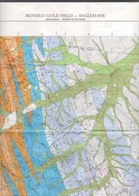
Map - STRUGNELL COLLECTION: GEOLOGICAL SURVEY OF VICTORIA, BENDIGO GOLD FIELD - EAGLEHAWK, 1992
Map, Geological Survey of Victoria, Bendigo Gold Field - Eaglehawk.Campaspe10 000/2.3; Victoria 1:10,000. Index of Shafts.Dept. of Manufacturing & Industry Developmentmap, bendigo, eaglehawk gold field -
 Bendigo Historical Society Inc.
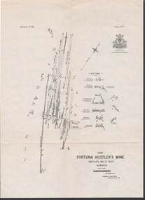
Map - STRUGNELL COLLECTION: HUSTLER'S LINE OF REEFS, BENDIGO, September 1913
Map, Hustler's Line of Reefs, Fortuna Hustler's Mine, Plan, Plate No.11(2).Bulletin No 33 Signed H.A.Whitelaw.Underground Survey Office, Bendigo.map, bendigo, fortuna hustler's mine -
 Port Melbourne Historical & Preservation Society
Map - Route of US Navy Great White Fleet, 2008
Large photocopy of map of the world with the route of the Great White Fleet (US Navy) 1908 marked in red and white tapearmed services - navy, great white fleet, us navy -
Port Melbourne Historical & Preservation Society
Map - Melbourne and suburbs, MMBW, 8 Dec 1909
MMBW map of Melbourne and suburbs - Record plan up to July 1st 1913 (scale 3/4" = 1 mile)engineering - board of works, calder e oliver, russwaul(?) -
 Churchill Island Heritage Farm
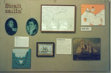
Photograph - Photograph of 'Strait sailin'' Visitor's Centre Display
Churchill Island Heritage Farm has a large photograph collection dating from the nineteenth century. Photograph of 'Strait sailin'' Visitor's Centre Display showing portraits of Matthew Flinders and George Bass with maps and informational text.Catalogue number on reverse in pencil.churchill island, photograph -
 Bendigo Historical Society Inc.
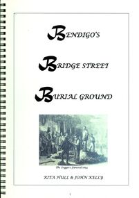
Book - BENDIGO'S BRIDGE STREET BURIAL GROUND
Bendigo's Bridge Street Burial Ground, 53 pages in a spring bound binder with black and white photographs, maps & illustrations.Rita Hull & John Kellybook, bendigo, cemeteries, bendigo-history-cemeteries -
 Bendigo Historical Society Inc.
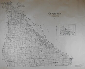
Map - JACK FLYNN COLLECTION: COUNTY OF GUNBOWER, 1935
Map; County of Gunbower. Sheet containing the whole of the County, showing parishes within. Scale 2 Miles to 1 inch.map, gunbower, parish plan, gunbower -
 Bendigo Historical Society Inc.
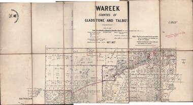
Map - JACK FLYNN COLLECTION: WAREEK, Examined 1918
Map: L.1053. Parish of Wareek, Counties of Gladstone and Talbot. Parish plan. Looks like half of the sheet is missing.Second Issue. Examined by S.F. Green. July 1918. William J. Swan, Draughtsman, August 1884. Photo-Lithographic Fac-Simile, W 36.map, gladstone, parish plan, wareek -
Bendigo Historical Society Inc.
Map - EPSOM ?, Circa 1880
Map: Parish plan showing an area Southwards from the parish of Huntly boundary, Covering Epsom,Ascot and White Hillsmap, bendigo, parish plan, epsom, ascot, white hills -
Bendigo Historical Society Inc.
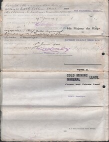
Document - MCCOLL, RANKIN AND STANISTREET COLLECTION: PROSPECTUS OF DEBORAH UNITED GOLD MINING COMPANY NL, DEBORAH REEF, 1940
Document: McColl, Rankin and Stanistreet: , grey booklet. Prospectus of Deborah United Gold Mining Company. Includes map of minesorganization, mining, deborah united gold mining company, mccoll, rankin and stanistreet: , deborah united gold mining company nl, deborah reef, prospectus -
 Bendigo Historical Society Inc.
Document - MCCOLL, RANKIN AND STANISTREET COLLECTION: NAPOLEON REEF GOLD MINING CO. N.L, 1938
5 Page Legal Document with map of lease area, 6 land application forms (see attached pdf for details).organization, business, industrial - mining, mccoll rankin & stanistreet, mining, gold mining, napoleon reef -
Bendigo Historical Society Inc.
Map - METCALFE, 30/10/1878
Map: Metcalfe, County of Dalhousie. Parish plan (also has a smaller addition glued onto the right hand side)map, dalhousie, parish plan, metcalfe -
 National Vietnam Veterans Museum (NVVM)
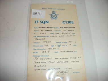
Card, 37 Squadron C130E
RAAF yellow card with blue printing. On the back is hand written information. World map (partial) in blue ink on the back.37 sqn raaf -
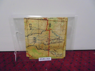 National Vietnam Veterans Museum (NVVM)
Map
A laminated coloured military map showing topography of areas around Nui Dat with divisional sections hand drawn in black.map, nui dat, mcphail collection -
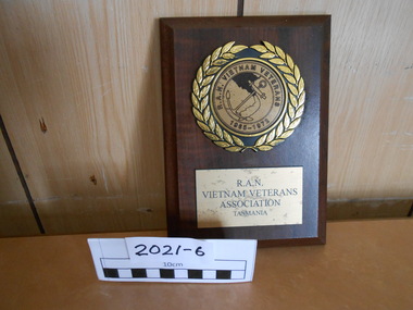 National Vietnam Veterans Museum (NVVM)
Plaque
A wooden shield with a round gold laurel with anchor and Vietnam map in the centre. Also R.A.N. Vietnam veterans 1965 - 1972On a plaque reads R.A.N. VIETNAM VETERANS ASSOCIATION TASMANIAshield, hmas cerberus, cerberus collection -
Clunes Museum
Map
Photocopy of map Underground Survey of mines at Clunes Clunes Goldfields Co. (two sheets joined) Port Phillip Co.Nilcartography, clunes mines, clunes goldfield co. -
Tatura Irrigation & Wartime Camps Museum
Stapled leaflets, Kathy and Conn Prestegar, The Winter Family, 1990
History of the Winter family as they settled the area.Photo copies of history of the Winter family with map of land selected and owned by the Winters. Leaflets in plastic cover. ( 9 pages). "From Kathy and Conn Prestegar." on front cover. -
Tatura Irrigation & Wartime Camps Museum
Book, Soldiering On, 1942
The stories were contributed by members of the Australian Army. They had been prepared in the field in brief hours off duty, often by the flickering light of a hurricane lamp in a black-out camp and sometimes within hearing of the front-line guns.Red hard cover with beige printing on front cover and spine. Text, black and white and coloured sketches, pictures and mapsww1, books, history, local -
Tatura Irrigation & Wartime Camps Museum
Book, Seedtime and Harvest in New Guinea by Pastor E.A. Jeriicho
Tells the story of Mission Personnel who were killed on a Japanese transport which was taking prisoners from Finschhafen to Hollandia in New Guinea.Soft cover book, tan coloured paper with brown writing and map of New Guinea on front cover. 160 pages.lutheran missionaries, missionaries in new guinea, missionary prisons of war, new guinea in ww2 -
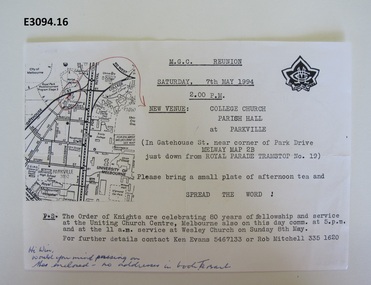 Uniting Church Archives - Synod of Victoria
Document - Invitation, MGC Renunion
This in an invitation for a Methodist Girls' Comradeship reunion to be held on Saturday 27 May 1994 at 2 pm at College Church parish hall, Parkville. Single sheet of white paper with black typewritten text, MGC badge and map. There is a handwritten message in blue ink at the bottom."Hi Win, Would you mind passing on the enclused - no address in the book. Ta Barb"methodist girls' comradeship, methodist order of knights, college church parkville, ken evans, rob mtichell, win mountford, barbara harrison -
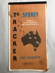 Robin Boyd Foundation
Map, Pic-touring Australia, Tracker to Sydney
Includes the blue mountains and Illawarra districts. beautiful simplified coloured maps. Price 7/6, so pre-decimalisationwalsh st library -
Lakes Entrance Regional Historical Society (operating as Lakes Entrance History Centre & Museum)
Book, Regional Coordination Group and Strategy Steering Committee, The East Gippsland Planning and Development Strategy, 1997
An outline of planning and proposed development by the East Gippsland, Victoria, Shire Council from 1997 to the year 2010. Maps included.township, land settlement, tourism -
Lakes Entrance Regional Historical Society (operating as Lakes Entrance History Centre & Museum)
Book, Mallacoota and District Historical Society, A Story of Mallacoota
A brief history of Mallacoota district, Victoria, from 1837 to the 1930's. Includes a time line, sketch maps and photographs.aboriginals, settlers, township, ships and shipping -
Lakes Entrance Regional Historical Society (operating as Lakes Entrance History Centre & Museum)
Book, Dyce, G.R, Combienbar The Valley of Contentment, 1982
An account of the early settlers of Combienbar, East Gippsland, Victoria - their struggles and achievements to 1945. Illustrated with photographs and includes map of the valley.settlers, agriculture, mines and mining -
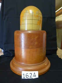 Stawell Historical Society Inc
Memorabilia - Realia, 1943
Lamp. Polished Wooden Base. World Map painted o Mercator's for projection. Timber from first Anglican Church.stawell, education -
Wangaratta Art Gallery
Textile, Patrick Snelling, 8.9, 0ct 2010 - Mar 2011
The textile traditions and aesthetics of Japan have always influenced my textile practice and I have created a construct that reflects the way this work has been developed and assembled. The grouping of hand and digitally printed textile hexagons, represent a meta language of patterns and techniques. There are classical Japanese motifs and very contemporary images that have been captured digitally from my visits to Tokyo and Kyoto. My combining the old and the new forms of textile printing, I am creating a traditional and contemporary conversation between processes. This work was started in October 2010, it was put aside for a few months and then I re-imagined it again with the tragic news coming out of Fukushima and Miyagi provinces.Wangaratta Art Gallery Collection. Winner of 2011 Wangaratta Contemporary Textile Award.Hexagon pieces of patterned fabric in varying shades of green, pink and yellow, which are arranged together to form a map of Japan.wangaratta art gallery, textile, wcta, patrick snelling -
Stawell Historical Society Inc
Map, Crowlands & Navarre Railway Construction Trust, VR Plan Showing Railway Construction District Crowlands to navarre Line 1916, 4 July 1916
Two (2) Very large Coloured Maps. Scale 40 Chains to 1 Inch. rail Line Drawn in RedShire of Kara Kara. Shire of Stawell Shire of Ararat 4 July 1916railways -
Whitehorse Historical Society Inc.
Document, Vermont pre 1890, 1985?
Short history of Vermont, pre 1890. Nunawading Historical Society competition, first prize, open section. With maps and photographs.Short history of Vermont, pre 1890. Nunawading Historical Society competition, first prize, open section. With maps and photographs.Short history of Vermont, pre 1890. Nunawading Historical Society competition, first prize, open section. With maps and photographs.vermont, nunawading -
Whitehorse Historical Society Inc.
Pamphlet, Heritage Walk
Pamphlet describing a walk around Blackburn Lake and giving some of the history of the lake and its surrounding area. Includes map.Pamphlet describing a walk around Blackburn Lake and giving some of the history of the lake and its surrounding area. Includes map.Pamphlet describing a walk around Blackburn Lake and giving some of the history of the lake and its surrounding area. Includes map.blackburn lake, adult deaf and dumb society, lake park, flower growing, heidelberg school -
Whitehorse Historical Society Inc.
Letter - Correspondence, Valuation of Abattoirs Paddock lots, 1932
Letter from Shire valuer to Cit of Box Hill re valuations of Abattoir Paddock lots, including map of lots.Letter from Shire valuer to Cit of Box Hill re valuations of Abattoir Paddock lots, including map of lots.Letter from Shire valuer to Cit of Box Hill re valuations of Abattoir Paddock lots, including map of lots.shire of blackburn and mitcham, city of box hill, abattoirs paddock, aspinall's estate, woodhouse grove, box hill north