Showing 13843 items matching "tasmanian-built"
-
 Bayside Gallery - Bayside City Council Art & Heritage Collection
Work on paper - ink and watercolour, Annette Meikle, Moysey Memorial, 1977
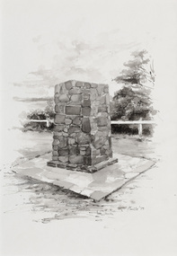
In 1977, artist Annette Meikle undertook a commission to illustrate a book recording stories of places and people in the Bayside area. It was published in 1978 as Sandringham Sketchbook, with text by Elizabeth Waters. The sketches were intended to record remaining examples of Bayside’s early architecture and environment, as well as reflect newer architectural changes. Meikle went on to donate 22 of these sketches to Bayside City Council in 2003. Erected in 1964, this stone cairn on Beach Road in Beaumaris marks the site of the wattle and daub cottage of James and Susannah Moysey. James, Susannah and their cousin Nicholas arrived in Victoria in 1844 and leased land on the cliff-top. They built a cottage, cleared the land for sheep and cattle and established vegetable gardens. They later purchased the land and named it Beaumaris Park, derived from the name of the Welsh coastal resort where Edward I built Beau Marais castle.Annette Meikle, Moysey Memorial 1977, ink and watercolour, 35 x 23.5 cm. Bayside City Council Art and Heritage Collection. Donated by the artist, 2003annette meikle, sandringham sketchbook, elizabeth waters, port phillip bay, moysey memorial, coastline, stone cairn, james and susannah moysey, beaumaris -
 Kew Historical Society Inc
Photograph, J E & B L Rogers, 'Swinton', Swinton Avenue, c.1960
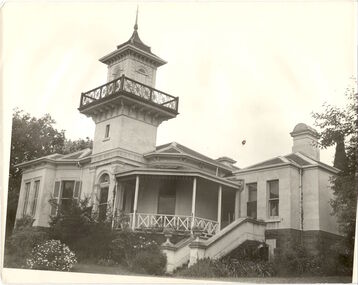
'The land on which 'Swinton'was later built was first purchased by John Bakewell in 1851 and later sold to Edmund Laskey Splatt in 1858. Splatt was a member of the first provisional committee of the National Bank of Australia in Melbourne and built the first house on the land naming it 'Laskey Villa'. By 1863 the house was occupied by Herbert Henty. The Johnson family connection with the property began with the marriage in 1858 of Annabella Johnson to David Syme, owner of the Áge' newspaper and owner of the adjacent property 'Blytheswood'. Annabella's brother, Francis Johnson, bought the villa in 1876 and renamed it 'Swinton' after his birthplace in Yorkshire. The property was later owned by the artistic Colquhoun family. The house is one of the earliest examples of the Italianate style in Victoria - the outstanding element being the tower with its cantilevered walkway and heavily bracketed pryamidal tower.' Source: Victorian Heritage RegisterThis work forms part of the collection assembled by the historian Dorothy Rogers, that was donated to the Kew Historical Society by her son John Rogers in 2015. The manuscripts, photographs, maps, and documents were sourced by her from both family and local collections or produced as references for her print publications. Many were directly used by Rogers in writing ‘Lovely Old Homes of Kew’ (1961) and 'A History of Kew' (1973), or the numerous articles on local history that she produced for suburban newspapers. Most of the photographs in the collection include detailed annotations in her hand. The Rogers Collection provides a comprehensive insight into the working habits of a historian in the 1960s and 1970s. Together it forms the largest privately-donated collection within the archives of the Kew Historical SocietySwinton in Kew and its tower. This side of the house faces the Yarra River.swinton, laskey villa, swinton avenue, kew, dorothy rogers -
 Kew Historical Society Inc
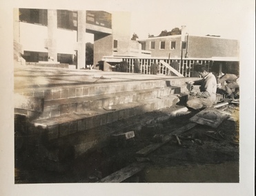
Photograph - Construction of the Kew Civic Centre, 1972
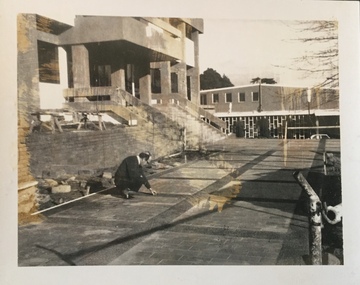
The Kew Civic Centre, as opposed to the adjacent Kew Civic Hall (see also Kew City Hall), was built to house a new Council Chamber and Council Offices in 1972. The Kew Library was to be located on the ground floor and accessed from the current carpark. This building replaced the former Town Hall in Walpole Street, Kew which had served as a town hall from 1865-1972. After the sale of the old Town Hall, the new Civic Centre was built to a design of the architects A K Lines, MacFarlane & Marshall. A fit-out of the building was still occurring when councillors and council officers moved into the building. In 1987, the Kew Library (and the Kew Historical Society) moved across the road to the reconfigured Civic Hall. The Civic Centre, pictured here, was ultimately sold to Trinity Grammar School following the amalgamation of Kew into the City of Boroondara.These four black and white photographs were taken by a photographer in the City Engineer's Department during the final construction phase. Each is dated and inscribed with a description.Laying of concrete tiles in the forecourt of the new Kew Civic Centre in 1972. The Civic Hall (now the Kew Library) is in the background. Annotated verso: "Civic Centre - Forecourt / 17.7.72"kew civic centre, kew civic offices, city of kew -- council chamber -
 Kew Historical Society Inc
Photograph - Construction of the Kew Civic Centre, 1972
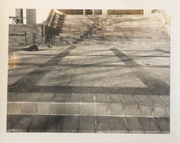
The Kew Civic Centre, as opposed to the adjacent Kew Civic Hall (see also Kew City Hall), was built to house a new Council Chamber and Council Offices in 1972. The Kew Library was to be located on the ground floor and accessed from the current carpark. This building replaced the former Town Hall in Walpole Street, Kew which had served as a town hall from 1865-1972. After the sale of the old Town Hall, the new Civic Centre was built to a design of the architects A K Lines, MacFarlane & Marshall. A fit-out of the building was still occurring when councillors and council officers moved into the building. In 1987, the Kew Library (and the Kew Historical Society) moved across the road to the reconfigured Civic Hall. The Civic Centre, pictured here, was ultimately sold to Trinity Grammar School following the amalgamation of Kew into the City of Boroondara.These four black and white photographs were taken by a photographer in the City Engineer's Department during the final construction phase. Each is dated and inscribed with a description.Forecourt of the new Kew Civic Centre in 1972.Annotated verso: "Civic Centre - Forecourt / 16.7.72"kew civic centre, kew civic offices, city of kew -- council chamber -
 Kew Historical Society Inc
Photograph - Construction of the Kew Civic Centre, 1972
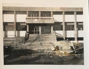
The Kew Civic Centre, as opposed to the adjacent Kew Civic Hall (see also Kew City Hall), was built to house a new Council Chamber and Council Offices in 1972. The Kew Library was to be located on the ground floor and accessed from the current carpark. This building replaced the former Town Hall in Walpole Street, Kew which had served as a town hall from 1865-1972. After the sale of the old Town Hall, the new Civic Centre was built to a design of the architects A K Lines, MacFarlane & Marshall. A fit-out of the building was still occurring when councillors and council officers moved into the building. In 1987, the Kew Library (and the Kew Historical Society) moved across the road to the reconfigured Civic Hall. The Civic Centre, pictured here, was ultimately sold to Trinity Grammar School following the amalgamation of Kew into the City of Boroondara.These four black and white photographs were taken by a photographer in the City Engineer's Department during the final construction phase. Each is dated and inscribed with a description.Tiling the steps leading from the forecourt to the new Kew Civic Centre in 1972.Annotated verso: "Civic Centre - Forecourt / 16.7.72"kew civic centre, kew civic offices, city of kew -- council chamber -
 Kew Historical Society Inc
Photograph - Construction of the Kew Civic Centre, 1972
The Kew Civic Centre, as opposed to the adjacent Kew Civic Hall (see also Kew City Hall), was built to house a new Council Chamber and Council Offices in 1972. The Kew Library was to be located on the ground floor and accessed from the current carpark. This building replaced the former Town Hall in Walpole Street, Kew which had served as a town hall from 1865-1972. After the sale of the old Town Hall, the new Civic Centre was built to a design of the architects A K Lines, MacFarlane & Marshall. A fit-out of the building was still occurring when councillors and council officers moved into the building. In 1987, the Kew Library (and the Kew Historical Society) moved across the road to the reconfigured Civic Hall. The Civic Centre, pictured here, was ultimately sold to Trinity Grammar School following the amalgamation of Kew into the City of Boroondara.These four black and white photographs were taken by a photographer in the City Engineer's Department during the final construction phase. Each is dated and inscribed with a description.Creating the forecourt to the new Kew Civic Centre in 1972.Annotated verso: "Civic Centre - Forecourt / 16.7.72"kew civic centre, kew civic offices, city of kew -- council chamber -
 Melbourne Legacy
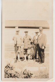
Photograph, Legacy Somers Camp, c1930
A black and white photo of a group of four men, most likely at Somers camp, probably in the 1930s. Second from left is Legatee Stan Savige. One man is holding rowing oars. It shows a building that had been built on Legatee Stan Savige's property. In the early years, Legacy organised outings to the property of Legacy founder, Legatee Stan Savige, who had a place in Balnarring close to the beach. Permanent camp buildings were built in 1930. In 1930 Lord Somers (Governor of Victoria) also started a camp at a nearby property and the area was renamed Somers. Legacy Somers Camps continued intermittently at Stan's property until it was decided in 1951 to make other arrangements for holidays. This photo was with a group of photos from around the 1930s from the early days of Legacy, including cricket team, football team, and camps at Balnarring/Somers (saved as 01915 to 01934).Legatee Savige's property at Balnarring became very important for Legacy providing outings and camps for junior legatees.Black and white photo of four men, including Stan Savige.Stamped on reverse with 'Kodak print' and 'X 657' in grey ink. Velox paper.legacy somers camp, savige property -
 Bacchus Marsh & District Historical Society
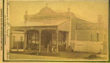
Photograph, Pearce Brothers Store Main Street Bacchus Marsh 1883
This store was built in 1881 and opened as a branch of Pearce Brothers main store which was further along in Main Street, Bacchus Marsh. The store in this image opened around early June 1881 and was described in the Bacchus Marsh Express as "quite above the usual standard of stores in towns of a similar or even much larger size. The building is most substantially built of brick, and measures 58 feet by 26 feet, with walls fourteen feet high inside. The interior is most elaborately fitted with shelves and glass cases covering both side walls and two ends formed by small offices separated from the main store by glass and wood panelled partitions, with a passage way between to the storeroom at the rear", Express, (Bacchus Marsh, 11 June, 1881, page 2). The building was designed by one of its proprietors T. G. Pearce and was entirely constructed by local contractors and workers.Small sepia unframed photograph on card with gold border framing photograph. Housed in the album, 'Photographs of Bacchus Marsh and District in 1883 by Stevenson and McNicoll'. The image depicts a general store with a double-front of windows. Goods such as spades, shovels, tubs and wringers are arrayed on the footpath in front of the store. At the front of the shop under a verandah stands a man, possibly one of the Pearce brothers who owned this business. Next to the store is a vacant block of land with a white picket fence. A sign erected above the fence advertises: “ Pearce Bros. Chaff. Hay & Oats. Produce. Dealer. “On the front: Stevenson & McNicoll. Photo. 108 Elizabeth St. Melbourne. COPIES CAN BE OBTAINED AT ANY TIME. On the back: LIGHT & TRUTH inscribed on a banner surmounted by a representation of the rising sun. Copies of this Portrait can be had at any time by sending the Name and Post Office Money Order or Stamps for the amount of order to STEVENSON & McNICOLL LATE BENSON & STEVENSON, Photographers. 108 Elizabeth Street, MELBOURNE. pearce family bacchus marsh, general stores bacchus marsh, shops bacchus marsh, pearce brothers general store bacchus marsh, stevenson and mcnicoll 1883 photographs of bacchus marsh and district -
 Glen Eira Historical Society
Album - Album page, Nithsdale now Five Way Hill, Kambrook Road, Circa 1972
This photograph is part of the Caulfield Historical Album 1972. This album was created in approximately 1972 as part of a project by the Caulfield Historical Society to assist in identifying buildings worthy of preservation. The album is related to a Survey the Caulfield Historical Society developed in collaboration with the National Trust of Australia (Victoria) and Caulfield City Council to identify historic buildings within the City of Caulfield that warranted the protection of a National Trust Classification. Principal photographer thought to be Trevor Hart, member of Caulfield Historical Society. Most photographs were taken between 1966-1972 with a small number of photographs being older and from unknown sources. All photographs are black and white except where stated, with 386 photographs over 198 pages. Glen Eira Heritage Management Plan (1996) by Andrew Ward and Associates - Vol 3 "Nithsdale", built for J.S. Crouchin 1858 and extended in 1885 with a tower and associated rooms, survives as testimony to the nineteenth century occupation of the vicinity of the Kambrook/Glen Eira Road intersection. Caulfield's Building Heritage by Dr Geulah Solomon, Vol 1 p49 records it as a small Victorian mansion home on bluestone foundations of Italianate style with a tower. Built for J S Chambers circa 1860, it was built in stages and then the land subdivided in the 1920s. Other owners include Adolph F Brockhoff (of Brockhoff Biscuits company). Names used besides Nithsdale have been Bundoora and Five Way Hill. Page 102 of Photograph Album with four photographs (three landscape and one portrait) of Nithsdale, now known as Five Way Hill. Three views of the tower and one of the house.Handwritten: "Nithsdale" now "Five Way Hill" Kambrook road [top right] / CNR KAMBROOK AND GLENEIRA ROADS [under bottom right photo] / 102 [bottom right]trevor hart, north caulfield, victorian, mid victorian, late victorian, tower, j.s. crouchin, 1850's, 1880's, italianate, rendered, five way hill, nithsdale, slate roof, plaster arches, ornamental columns, triangular pediment, ornamental parapet, cast iron balconies, kambrook road, glen eira road, t crouch, j s crouchin, mansions, j s chambers, bluestone foundations, land subdivision, adolph f brockhoff, bundoora, house names -
 Federation University Historical Collection
Booklet, Report on the Viability of Establishing a Post Secondary Education Facility Located at the Aradale Traininf Centre, Ararat, Victoria, 1993, 12/1993
Aradale is located 3 km from the centre of Ararat and covers approximately 101 hectares. It consistes of an impresive group of mainly heritage buildings of national significance surrounded by open farmland. Aradale was designed in 1864 in the Victorian Italianate style by John James Clark of the Public Works Department, Victoria. A three storey nurses quarters was built in the 1930s and the Forensic Psychaitry Centre was established in the 1980s. The design of asylums as a specific building type orginated in England in the mddle of the 19th century when it was decided that 'pauper lunatics' would be better cared for in a separate institution rather than being house within the workhouses. Some of the early purpose built asylums were based on the radiating principle of prisons but the arrangement of separat wings at right angles used in hospitals and whorkhouse design soon came to be seen as the most appropriate. The largest 19th century asylum in England was built at Colney Hatch. Kew, Beechworth and Ararat Asylums closely followed the Colney Hatch model. In victoria the population rose due to the gold rushes resulting in severe housing shortages, and additional pressure on asylums. The first asylum in Melbourne was established at Y arra Bend. In 1862 a new asylum was established at Kew. Ararat Asylum and Beechworth Asylum were designed in 1864. Ararat was opened on 19 October 1867, with Beechworth Asylum opening five days later. Soft covered bookletararat regional development board inc., aradale training centre, aradale, grano street ararat, alfred st ararat, ivar nelson, john christie, jon duggan, wes matthews, peter helfer, michael burke, john grant, asylum, lunatic asylum, colney hatch asylum, ararat asylum, fever tents, sunbury asylum, kew asylum, beechworth asylum, wine industry training -
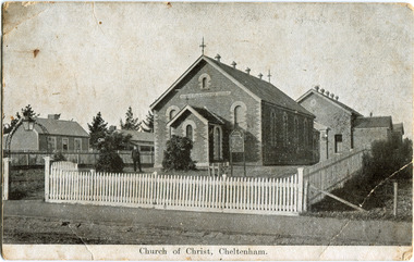 City of Moorabbin Historical Society (Operating the Box Cottage Museum)
Photograph - Black & White Postcard, Cheltenham Church of Christ 40th Anniversary Invitation, c1900
On his arrival from Scotland c 1857, James Keir commenced a communion service in his home on the Nepean Road. By 1859 the group-which included such other names as Allen, Brough, Cameron, Fairlam, Holdsworth, Le Page, Meeres, Monk, Organ, Penny, Perry, Potts, Sears and King-had built a small chapel near the corner of Wickham and Chesterville Roads. During 1858, a group had also begun meeting in the Charman family home on the corner of Charman and Balcombe Roads. Names associated with this group included Bodley, Charman, Fisher, Hayes, Hilliar, Judd, Moysey and Ruse. In 1860 they built a chapel on the corner of Charman Road and Patty Street. It was enlarged in 1866 and it became the meeting place of the two groups when they came together around 1870. They were able to buy land near the corner of Chesterville and Nepean Roads, and erected a new brick chapel on the site in 1878. This chapel, of course, continues to be an integral part of the life of the Southern Community Church and was one of the three worship venues for the 150th Anniversary celebration in 2007. The Southern Community Church was formed by the amalgamation of the Cheltenham, East Bentleigh and Hampton Street Churches of Christ in 1993, and a comprehensive new facility was designed and built to accommodate the ever-increasing activity of the amalgamated church. It was opened on 30th November 1997. ( Southern Community Church website 2019)c1878 - continuing The Church or Christ Cheltenham was one of the first places of worship established in Cheltenham by the early settlers. The settlers came together, in private homes at first, to support each other spiritually and physically and later built brick Churches for Sunday services and established social and sporting clubsBlack & White photograph as a postcard invitation to the 40th Anniversary of the Church of Christ corner Chesterville Rd and Nepean Highway Cheltenham ( ? 1900)Front Printed ; Church of Christ Cheltenham Back Printed ; POST CARD / One Penny Postage within Commonwealth / The address only to be written here/ One penny Stamp/ Sunday School Anniversary, / OCTOBER 27TH & OCTOBER 30TH / TO WHICH YOU ARE / CORDIALLY INVITED Handwritten in ink ; H.W. got the cramps in the pants. He took some pills then ran over the hills undatedearly settlers, bentleigh, mckinnon, parish of moorabbin, city of moorabbin, county of bourke, moorabbin roads board, shire of moorabbin, were j.b., o'shannassy john, king richard, charman stephen, highett william, ormond francis, maynard dennis, market gardeners, vineyards, orchards, keir james, lepage frank, lepage everest, holloway josiah, bruton henry, keys robert, judd clarence, fairlam percy, meeres william, southern community church, cheltenham, cheltenham church of christ -
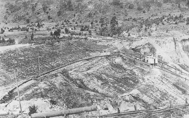
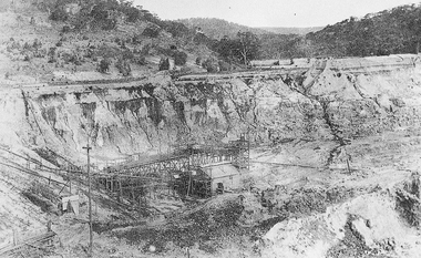
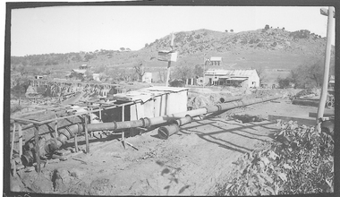 El Dorado Museum Association Inc.
Photograph (item) - Digital Image
Cocks Pioneer Electric Gold & Tin Mine Company was formed in 1899. The company's first power station, located at the eastern end of the valley began operating with its 340 Kilowatt steam-powered generator. By 1909, from 2,500,000 cubic yards worked, reported recovery was 17,284 ounces of gold and 224 tons of tin ore. By 1909, Cocks Pioneer’s power plant had become inadequate and uneconomical. The barge was floated downstream about a mile, but lost time caused the operations to cease. Following testing, a new mine was established by diverting Reid's Creek at a cost of £25,000. Settling dams were built, one of which held 1,935,900 cubic feet. Sold earth banks, built against a wall of stringy bark saplings constructed and laced with vertical props, were built. In 1914, the company was reformed as Cock’s Pioneer Gold and Tin Mines NL, another power station was constructed at the western end of the township, near the junction of Clear and Reid's Creeks. From 6,800,000 cubic yards of material processed, the returns were 64,397 ounces of gold and 855 ton of tin. Cocks Pioneer mine then moved the barge downs stream and continued sluicing. In 1929 Cocks Pioneer Electric Gold and Tin Mining Company ceased operations due to a drop in values. Cock’s Pioneer Gold and Tin Mines NL carried on large-scale hydraulic sluicing operations until 1941. mining, gold, tin, barge, sluicing, gold mining, tin mining, cocks pioneer, el dorado, eldorado -
 El Dorado Museum Association Inc.
Photograph (item) - Digital Image
Cocks Pioneer Electric Gold & Tin Mine Company was formed in 1899. The company's first power station, located at the eastern end of the valley began operating with its 340 Kilowatt steam-powered generator. By 1909, from 2,500,000 cubic yards worked, reported recovery was 17,284 ounces of gold and 224 tons of tin ore. By 1909, Cocks Pioneer’s power plant had become inadequate and uneconomical. The barge was floated downstream about a mile, but lost time caused the operations to cease. Following testing, a new mine was established by diverting Reid's Creek at a cost of £25 000. Settling dams were built, one of which held 1,935,900 cubic feet. Sold earth banks, built against a wall of stringy bark saplings constructed and laced with vertical props, were built. In 1914, the company was reformed as Cock’s Pioneer Gold and Tin Mines NL, another power station was constructed at the western end of the township, near the junction of Clear and Reid's Creeks. From 6,800,000 cubic yards of material processed, the returns were 64,397 ounces of gold and 855 ton of tin. Cocks Pioneer mine then moved the barge downs stream and continued sluicing. In 1929 Cocks Pioneer Electric Gold and Tin Mining Company ceased operations due to a drop in values. Cock’s Pioneer Gold and Tin Mines NL carried on large-scale hydraulic sluicing operations until 1941. gold, tin, mining, sluicing, gold mining, tin mining, cocks pioneer, el dorado, eldorado -
 El Dorado Museum Association Inc.
Photograph (item) - Digital Image
Cocks Pioneer Electric Gold & Tin Mine Company was formed in 1899. The company's first power station, located at the eastern end of the valley began operating with its 340 Kilowatt steam-powered generator. By 1909, from 2,500,000 cubic yards worked, reported recovery was 17,284 ounces of gold and 224 tons of tin ore. By 1909, Cocks Pioneer’s power plant had become inadequate and uneconomical. The barge was floated downstream about a mile, but lost time caused the operations to cease. Following testing, a new mine was established by diverting Reid's Creek at a cost of £25,000. Settling dams were built, one of which held 1,935,900 cubic feet. Sold earth banks, built against a wall of stringy bark saplings constructed and laced with vertical props, were built. In 1914, the company was reformed as Cock’s Pioneer Gold and Tin Mines NL, another power station was constructed at the western end of the township, near the junction of Clear and Reid's Creeks. From 6,800,000 cubic yards of material processed, the returns were 64,397 ounces of gold and 855 ton of tin. Cocks Pioneer mine then moved the barge downs stream and continued sluicing. In 1929 Cocks Pioneer Electric Gold and Tin Mining Company ceased operations due to a drop in values. Cock’s Pioneer Gold and Tin Mines NL carried on large-scale hydraulic sluicing operations until 1941. mines, mining, tin, gold, tin mining, gold mining, sluicing, cocks pioneer, el dorado, eldorado -
 El Dorado Museum Association Inc.
Photograph (item) - Digital Image
Cocks Pioneer Electric Gold & Tin Mine Company was formed in 1899. The company's first power station, located at the eastern end of the valley began operating with its 340 Kilowatt steam-powered generator. By 1909, from 2,500,000 cubic yards worked, reported recovery was 17,284 ounces of gold and 224 tons of tin ore. By 1909, Cocks Pioneer’s power plant had become inadequate and uneconomical. The barge was floated downstream about a mile, but lost time caused the operations to cease. Following testing, a new mine was established by diverting Reid's Creek at a cost of £25 000. Settling dams were built, one of which held 1,935,900 cubic feet. Sold earth banks, built against a wall of stringy bark saplings constructed and laced with vertical props, were built. In 1914, the company was reformed as Cock’s Pioneer Gold and Tin Mines NL, another power station was constructed at the western end of the township, near the junction of Clear and Reid's Creeks. From 6,800,000 cubic yards of material processed, the returns were 64,397 ounces of gold and 855 ton of tin. Cocks Pioneer mine then moved the barge downs stream and continued sluicing. In 1929 Cocks Pioneer Electric Gold and Tin Mining Company ceased operations due to a drop in values. Cock’s Pioneer Gold and Tin Mines NL carried on large-scale hydraulic sluicing operations until 1941. mining, mines, gold, tin, gold mining, tin mining, sluicing, cocks pioneer, el dorado, eldorado -
 El Dorado Museum Association Inc.
Photograph (item) - Digital Image
Cocks Pioneer Electric Gold & Tin Mine Company was formed in 1899. The company's first power station, located at the eastern end of the valley began operating with its 340 Kilowatt steam-powered generator. By 1909, from 2,500,000 cubic yards worked, reported recovery was 17,284 ounces of gold and 224 tons of tin ore. By 1909, Cocks Pioneer’s power plant had become inadequate and uneconomical. The barge was floated downstream about a mile, but lost time caused the operations to cease. Following testing, a new mine was established by diverting Reid's Creek at a cost of £25 000. Settling dams were built, one of which held 1,935,900 cubic feet. Sold earth banks, built against a wall of stringy bark saplings constructed and laced with vertical props, were built. In 1914, the company was reformed as Cock’s Pioneer Gold and Tin Mines NL, another power station was constructed at the western end of the township, near the junction of Clear and Reid's Creeks. From 6,800,000 cubic yards of material processed, the returns were 64,397 ounces of gold and 855 ton of tin. Cocks Pioneer mine then moved the barge downs stream and continued sluicing. In 1929 Cocks Pioneer Electric Gold and Tin Mining Company ceased operations due to a drop in values. Cock’s Pioneer Gold and Tin Mines NL carried on large-scale hydraulic sluicing operations until 1941. Handwritten across photograph: "PIONEER" - ELDORADO / F FOXCROFT PHOTO.mining, mines, gold, tin, gold mining, tin mining, sluicing, cocks pioneer, el dorado, eldorado -
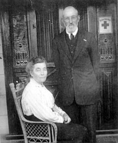 Surrey Hills Historical Society Collection
Photograph, Richard and Annie Bate at 'Camelford', 7 Norris Street, Surrey Hills, c1914/1915
Photo was taken in front of the front door of 'Camelford', 7 Norris Street. The presence of the red cross suggests that it was taken during the First World War. Two of the couples' surviving sons served in the war - Frederic George Bate (SERN 1945); Richard Alfred Bate (SERN 695); the third was rejected because he had lost a finger in an accident. Richard Bate came to Australia in 1868 from Cornwall - the house was named after the town there. He was a cabinetmaker and settled in Angaston, SA for a year before coming to Melbourne where he worked as a builder. He built ‘Avondale’, 176 Union Road (dem.) circa 1883 as a display home for the Davies family, subdividers of the first land auction in Surrey Hills. He built many houses including his retirement home at 7 Norris Street (demolished after 2000). In the 1880s Richard also built the Shire Hall in Station Street Box Hill, replaced in 1934 by the Box Hill Town Hall. Two of his sons were also carpenters. Richard died in 1937 aged 93 and his wife Annie Matilda died in 1935 aged 83; both are buried in Burwood Cemetery. House was rented out until probate was settled. Occupied in 2000 by Julie Ellis. REF: Letter to Julie Ellis from Jack Bate of Mildura, grandson of Richard and Annie Bate, dated 29/2/2000.A black and white photocopy of a photograph of a man dressed in a suit, standing beside a lady, seated, wearing a long sleeved, light coloured blouse and a long ankle length skirt. They are in front of a front door with lead light windows.mr richard bate, mrs annie bate, norris street, house names, camelford, avondale, union road, box hill shire hall, builders, ms julie ellis, davies family, annie matilda bate, richard alfred bate, frederic george bate, burwood cemetery, jack bate -
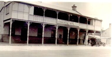 Port Fairy Historical Society Museum and Archives
Photograph
John J. Huntly appears to have been the only licensee of the Royal Oak Hotel, built in 1858. He was a Councillor of the Municipality of Belfast at the time and later became the Secretary of the newly formed Minhamite Shire in 1872. By 1861 D. Smith appears as the licensee of the now named Commercial Hotel. In 1877 it was offered for sale—the building described as “Built of bluestone with slate roof, having a frontage to Bank street of 106 feet, 6 inches. Accommodation consists of twelve bedrooms, eight sitting rooms, bathroom, bar and cellar and detached kitchen also of bluestones, with outside offices. Around this time beside its usual business the hotel had various rooms for visiting doctors and a dentist. Dr. Berncastle, who was associated with the Sydney Eye Infirmary, performed several operations there on those suffering from cataracts. It was the meeting place for the Port Fairy Freemasons, before their Lodge was built in James street, and all the local sporting clubs, at one time or another. The sign on the hotel states "Fitzgerald's Commercial Hotel" more research is being undertaken as to this owner or lessee. The veranda was added in 1900. The name Royal Oak was restored this century, but the name Commercial Hotel can still be seen in the leadlight window over the front entrance. The hotel has now been transformed into apartments and a restaurant called the Oak and Anchor Image of the hotel at an earlier timeBlack and white photograph of Two story bluestone painted commercial hotel with large verandah car at kerbhotel, building, bank street, john j huntly, d smith, royal oak, commercial, fitzgerald, kemp, oak and anchor -
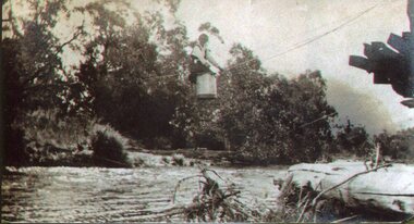
 Falls Creek Historical Society
Photograph - Harbour Bridge over Watchbed Creek
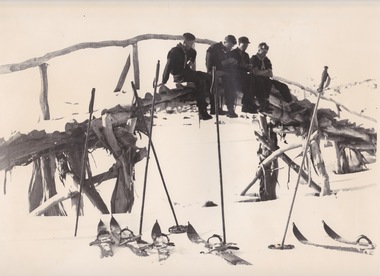
The late W.F. “Bill” Waters, Rover Commissioner of Victoria, was introduced to skiing in November 1930 at the International Scout Chalet at Kandersteg in Switzerland. He believed it would be a good activity for Victorian Rovers to be involved in to learn more about the Victorian Alps The first Rover ski trip to the Bogong High Plains was in the August of 1932 when a group of four crossed the High Plains from Omeo to Harrietville via Tawonga Huts, Cobungra Gap, Mt Loch and Mt Feathertop. In 1933 the Bogong Rover Crew was formed and in 1938 funds were collected and life memberships offered to raise funds to build a Rover Chalet for the purposes of skiing. During February and March1940, the Chalet was built at a cost of £700 using volunteer labour. It was the first ski lodge in the area and was built long before there was a road over Watchbed Creek. After the road to Rocky Valley was finished it was easier for the scouts to walk in from there instead of from Shannonvale. During the spring thaw the creek became almost impassable. Joe Holsten who was an SEC employee who worked with Martin Romuld out of Wilkinson’s Hut built a bridge across the creek made entirely from snow gums which he had to haul about 300 metres from the nearby hills. It became known as the Harbour Bridge as it arched over the water just like the Sydney Harbour Bridge.These images are significant because they depict an early bridge structure to enable easier travelling across the Bogong High Plains.Three black and white photos taken at the Harbour Bridge, Watchbed Creek.harbour bridge bogong high plains, watchbed creek, joe holsten -
 Eltham District Historical Society Inc
Photograph, Periwinkle House (1948); Bob and Ada Zull House (1970)
Images 9A and 9B 9A 'Periwinkle House' 1948 For Mr and Mrs J Holmes Built by Sonia Skipper, Horrie Judd, Tony Jackson and others Designed by Alistair Knox 9B Bob and Ada Zull house built 1970 Designed and built by Alistair Knox Floor laid by Ada Zull The Alistair Knox Collection The Alistair Knox Collection is a series of mounted enlarged photos of mud brick houses and related subjects. The collection is understood to have been put together by Alistair Knox although it is the work of several unacknowledged photographers. For some years it was held by the Building Department of the former Eltham Shire Council and was then passed to our Society for safekeeping. Some of the photos have been used in Knox's books and from time to time some of them have been part of various historical displays. As far as we know there has not been a public display of the whole collection which numbers about forty photographs. The collection has been copied on to slides for the purpose of this meeting and to be retained as part of the Society's pictorial collection. Alistair Knox 1912 - 1986 is acknowledged as the founder of Eltham's mud brick building movement. Many of the buildings shown in the collection are of his design and he was also involved with the construction of several of them. Others are the work of his contemporaries and associates such as Peter Glass, Gordon Ford, and John Harcourt. (EDHS Newsletter No. 145 July 2002)Handwritten notes in pencil re details of building, year of construction, owner, designer, builder, etcada zull, alistair knox, alistair knox design, bob and ada zull house, bob zull, horrie judd, houses, j holmes, mud brick construction, periwinkle house, sonia skipper, tony jackson, alistair knox collection -
 Flagstaff Hill Maritime Museum and Village
Uniform - Bicorn Hat and Hat Box, late 19th - early 20th century
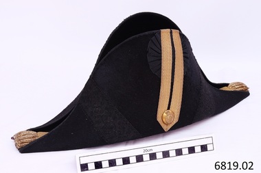
This hat and hat box was donated to Flagstaff Hill Maritime Village by the family of Doctor William Roy Angus, Surgeon and Oculist. It is part of the “W.R. Angus Collection” which includes historical medical equipment, surgical instruments and material once belonging to Dr Edward Ryan and Dr Thomas Francis Ryan, (both of Nhill, Victoria) as well as Dr Angus’ belongings. The Collection’s history spans the medical practices of the two Doctors Ryan, from 1885-1926 plus that of Dr Angus, up until 1969. McDade is the surname of Dr Angus’ daughter Berry (Berenice) McDade nee Angus. This had belonged to her father Dr William Roy Angus, Surgeon and Oculist (1901 –1970), who wore it on the ship T.S.S. LARGS BAY when travelling from Australia to Scotland for extended studies to be a “Fellow” of the Royal College of Surgeons in Edinburgh in 1929. This bicorn, cocked hat was worn with narrow points towards the front and back. It is decorated with flat gold braid or ‘lace’ with a geometrical design. Regimental lace was worn on the uniform and headdress of regimental officers in the 19th century. Gold lace chevrons were worn on coats to signify rank. Drummers and Foot Guards also wore regimental lace to distinguish them from other military personnel. In the late 19th century the English and Welsh infantry officers’ uniforms displayed a rose-pattern lace. The gold bullion and underlying crimson ‘eyes’ have been used to signify the rank of the owner. Crimson eyes were used for military personnel, and blue eyes were used for naval personnel. Different numbers and colours of the bullion and eyes may have been used to represent different military ranks. The Regulations specify nine tassels and eleven underlying eyes but there could have been variations. We have not yet identified the rank for this particular hat but hats such as this were part of the Australian and British naval uniforms in the early 20th century. The gold button’s emblem features a cross with five stars, a crown, and the motto “AUT PACE AUT BELLO,” which translates as “either in peace or in war.” Museum Victoria has a similar button and writes that buttons with this design were used by the Victorian Volunteers in the nineteenth century. The Australian War Memorial Curator of Military Heraldry advised Museum Victoria that these buttons dated from 1880 to 1892 and were worn by regular, unranked soldiers. Tasmanian Midshipman Alan Casey, who served the British and Australian Navy from 1919 to 1933 and retired as a Lieutenant Commander, owned a similar officer's bicorn hat. His hat and epaulettes are in the Tasmanian Maritime Museum's collection. The Australian War Memorial has a hat that is very similar in design, described as an “Artillery Staff Officer’s cocked had with plume, worn by Volunteer Artillery Staff in the Victorian Colonial Military Forces”. That hat is different in that it has a plume and the braid and button are silver. Berry MdDade, the donor, has used the hat many times as a dress-up hat but doesn’t know the origin of it. The hat seems to fit the design of the Staff Officers in Victorian Volunteers in Colonial times, but the button on this hat was used for unranked volunteers. Also, military uniforms usually have very clear manufacturer’s labels, as they are made by reputable companies under contract to the Defence Department. The manufacturer’s mark is not discernible on this hat. The origin, original wearer and use of this particular hat is unclear. The military bicorn cockade hat belonged to Dr William Roy Angus and is part of the W.R. Angus Collection. It is significant for still being located at the site connected to Doctor Angus being the last Port Medical Officer in Warrnambool. The collection of medical instruments and other equipment is culturally significant, as an historical example of medicine from late 19th to mid-20th century. Dr Angus assisted Dr Tom Ryan, a pioneer in the use of X-rays and in ocular surgery. Black bicorn cocked hat and case. It appears to be part of a 19th-century Colonial full-dress naval officer's uniform. The long, narrow crescent-shaped hat is made of beaver fabric and the crown is lined with crimson silk and finished with a hand-stitched leather sweatband. On one flat side is a pleated black silk, lace cockade woven in the pattern of oak leaves and acorns. The cockade is overlaid with a double row of gold lace braiding secure with a Victorian Volunteer’s gold button. Wide diagonal bands of black lace braid trim are on each side of the gold braiding. The other side of the hat is plain. The front and back points of the hat each have seven gold bullion tassels with nine underlying twists of crimson ‘eyes’. The fitted metal carry case has a catch and a plaque on one side. The button bears a crown and cross with five stars and a motto. Inside the hat is a white name tag with clear adhesive over it, with black printed text with the name “Mc Dade”. The hat is part of the W.R. Angus Collection.The hat has no maker’s marks although there is a darker colour in the centre where there could have been a label. Inside the hat is taped a printed label; “Mc DADE 801 1032” Button’s emblem- a cross with five stars, under a crown, all within a buckled belt with the motto “AUT PACE AUT BELLO” [either in peace or in war] The plaque on the case has no legible marks.flagstaff hill, warrnambool, shipwrecked coast, flagstaff hill maritime museum, maritime museum, shipwreck coast, flagstaff hill maritime village, great ocean road, dr w r angus, t.s.s. largs bay, berry mcdade, 19th century colonial military uniform, artillery staff officer’s cocked had, victorian volunteers, victorian colonial military forces, colonial militia, aut pace aut bello, cocked hat, cockade hat, bicorn hat, military bullion, oak leaves and acorns pattern, gold bullion tassels, military heraldry, w.r. angus collection., australian navy, british navy, uniform -
 Kiewa Valley Historical Society
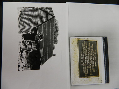
Wilkinson Lodge - copies of 6 photos, 1 plaque, 1 article
Wilkinson's Hut was built for the State Electricity Commission of Victoria in 1932 as a permanent residence for the snow research program manager, who was the resident engineer of the Kiewa Hydro Electric Scheme. The hut was sold in 1948 to the Ski Club of Victoria / Victorian Alpine Club and renamed Wilkinson Lodge. In 1958 it was sold to the Melbourne Bushwalkers Club. It was burnt down on 17th January 2004.Wilkinson Lodge was located at Wallace Gap on the Bogong High Plains and was the first S.E.C.V. permanent residence for the workers of the Kiewa Hydro Electric Scheme. It is also an early built lodge owned briefly 1946 - 1958 by the Ski Club of Victoria / Victorian Alpine Club and used by skiers before other lodges were built at Falls Creek. It was used by bushwalkers until it was burnt down thus in itself depicting part of the history of the area.5 pages of copies of photos of Wilkinson Lodge, 1 page of a copy of the destruction of Wilkinson Lodge (6 small photos), 1 page of a copy of a plaque titled 'This cottage' and 1 page of an article from the Border Mail (newspaper) dated 19th Jan. 2004.wilkinson hut; secv; ski club of victoria; melbourne bushwalkers club; fire -
 Kiewa Valley Historical Society
Photo - Tawonga Bridge.( Set of 2 photos)
Photo 1 - Rene Roper (Postmistress) crossing swollen Kiewa River on a milk can flying fox at Tawonga, during high winter waters Photo 2 - First Tawonga bridge was built in 1884- destroyed by floods in 1916. New bridge constructed 1923 and destroyed in 1953. Present concrete bridge constructed in 1986 and named Ryders BridgeBridge construction over Kiewa River at TawongaCopies of two original black and white photos. Photo 1 - Flying fox at site of Tawonga Bridge over the Kiewa River Photo 2 - Timber pile bridge over the Kiewa River at Tawongatawonga bridge, kiewa valley -
Glen Eira Historical Society
Newspaper - Stanlee Private Hospital, Hawthorn Road, 16, Caulfield North
Two documents about this address: 1/a photograph of refurbished hospice built in 1916, details of building, now three apartments, in advertisement for forthcoming auction. Dated 09/12/2009 in Melbourne Weekly Bayside. 2/Brief research notes by Claire Barton on 28/02/2012 from 1923 Sands and McDougalls for this property called Stanlee Private Hospital.hawthorn road, wanda road, hospitals, hornsey miss, johnson miss, moss miss, stanlee private hospital , caulfield north, flats, peer gary, estate agents -
Glen Eira Historical Society
Document - Kooyong Road, 110, Caulfield North
Copy of typed letter 27/05/1989 from Brighton Historical Society giving details of history/owners/tenants of 110 Kooyong Road, Caulfield North from 1840 to 1985. Accompanied by handwritten working notes naming owners/tenants of property 110 Kooyong Road, North Caulfield from 1936 to 1985. House was built in 1936.kooyong road, rosemont farm, howitt godfrey dr, settlers, caulfield north, howitt alfred, henderson garnet w., henderson m.m. miss, haskin joseph, anstee w.e., holst edward, bullock hilary, landells rosalind, land subdivision -
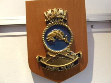 Waverley RSL Sub Branch
Plaque H.M.A.S. Otama, H.M.A.S. Otama
HMAS Otama (SS 72/SSG 72) was an Oberon class submarine of the Royal Australian Navy (RAN). Built in Scotland, the submarine was commissioned into the RAN in 1978; the last of the class to enter service. Otama remained in service until late 2000, when she was decommissioned and sold to a Victorian community group, who planned to preserve the submarine as a museum ship.Wooden Plaque 15cm x 13cm with insignia of H.M.A.S. Otama H.M.A.S. Otama -
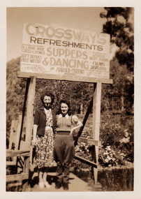 Marysville & District Historical Society
Photograph (Item) - Black and white photograph, 1948
A black and white photograph of two unknown ladies standing under the sign at The Crossways in Marysville. The Crossways was built in the early 1920s and is the oldest building in Marysville. The Crossways historic inn survived the 2009 Black Saturday bushfires thanks to the efforts of its c-owner Greg Cherry and, in the days after the fires, provided a much-needed refuge to the Marysville community and firefighters. A black and white photograph of two unknown ladies standing under the sign at The Crossways in Marysville.MARYSVILLE 1945marysville, victoria, australia, photograph, crossways, crossways cabaret, crossways historic inn, crossways country inn, accommodation, 2009 black saturday bushfires -
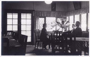 Marysville & District Historical Society
Photograph (Item) - Black and white photograph, Roy Liebig, 04-1949
A black and white photograph taken in a dining area in the Crossways Cabaret in April, 1949. The Crossways was built in the early 1920s and is the oldest building in Marysville. The Crossways historic inn survived the 2009 Black Saturday bushfires thanks to the efforts of its c-owner Greg Cherry and, in the days after the fires, provided a much-needed refuge to the Marysville community and firefighters. A black and white photograph taken in a dining area in the Crossways Cabaret in April, 1949.My wife Katie,/ does a little talking/ at the Crossways Cabaret./ Marysville Visit,/ April 1949.marysville, victoria, australia, photograph, the crossways cabaret, the crossways, crossways, crossways country inn, crossways historic inn, 2009 black saturday bushfires, accommodation, roy liebig -
 Phillip Island and District Historical Society Inc.
Photographs, Fuji Film, 2010
The original hospital was built in 1924 and the new building opened in 1962. It was closed after not being able to receive funding from State and Federal Governments. It's doors closed on January 31st 2008. A section of the hospital was run as a Nursing Home which opened in 1980. That too is closed. The "old" Cowes Medical Centre building is used for auxiliary medical services.Four coloured photographs of the Warley Hospital, Nursing Home and "old" Cowes Medical Centre, with a For Sale board showing "sold". warley hospital, carrol ryan -
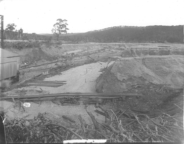
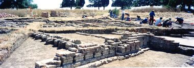 Greensborough Historical Society
Photograph - Photograph Collection, Jan Macdonald, Viewbank Homestead archaeological excavation 1999, 1999
In 1999, an archaeological dig was undertaken at the Viewbank Homestead site in Viewbank. This set of photographs was taken at the dig site in 1999. The house was built c1840 by James Williamson; it was later purchased by George Gear as a wedding gift to his daughter on her marriage to Dr Robert Martin. It became a grand mansion in the late 1800s but by the 1920s, it was stripped bare of materials and demolished in the 1920s. The archaeological dig was and insight into early life in the Viewbank HomesteadSet of 8 panoramic photos of archaeological dig and flyer for dig.viewbank homestead, banyule road viewbank, viewbank, archaeological digs