Showing 22200 items
matching parks
-
 Ballarat Heritage Services
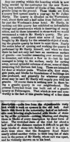
Newspaper - Newspaper article, Newsclipping Relating to Stonemason Julien Hardy
Julien Hardy was the first discoverer of gold at Happy Valley. A stonemason, he was born at Vire, Normandy, France. He established a stone quarry on the Melbourne Road, near Warrenheip (on the site now occupied by Shady Acres Caravan Park). From here, he quarried blocks that were used in the Ballarat Town Hall.Newsclippingjulien hardy, stonemason, gold, happy valley, shady acres, warrenheip, ballarat town hall -
 Ballarat Tramway Museum
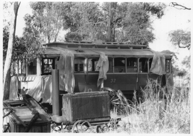
Photograph - Tram 32 Maryborough Park, late 1972
The photograph shows SEC Ballarat tram Nos. 32 on-site at the proposed Maryborough Chamber of Commerce "Wildlife" park. This did not proceed. The photo is most likely taken before a roof was placed over the tram. The date and Photographer are unknown. See item 6604 and 6632 for other photos. The tram was acquired by the BTPS in 1986.Yields information about tram 32 at the proposed Wildlife page.Black and White print on plain paper.tramcars, tram 32, maryborough, transporting trams -
 The Beechworth Burke Museum
Photograph, c1960
The photograph depicts a view across the water at Lake Sambell. The image dates from approximately 1960. The present day park and reserve occupies the site of the former Rocky Mountain Mining Company, an open-cut sluice mine that began operations in the mid-Nineteenth Century and operated until the early 1900s, through the peak of Victoria’s Gold Rush. It was converted into a park and leisure area in the 1920s. Lake Sambell was formally opened to the public on Friday 5th October 1928 and was opened by the Victorian Government’s Minister of Lands, Mr Bailey, as part of initiatives to boost the economies and development of country towns. The lake was named after Mr L.H. Sambell, a shire engineer and secretary of the Forward Beechworth Committee who was involved in promoting the transformation of the mining site and promoting plantation forestry and tourism as alternative industries. £300 to begin the process was provided by Mr J. McConvill, a former resident of Beechworth, who is remembered in a street name adjacent to the lake. Residents of Beechworth have worked to raise funds to improve the Lake Sambell reserve several times, such as efforts in the 1930s and 1940s to raise the banks several feet to deepen the water for swimming purposes. Fundraising campaigns include the ‘Ugly Man’ competition conducted on behalf of the Wallace Park-Lake Sambell Development Scheme. The latter competition was run by the Fire Brigade Bend’s team as part of a larger competition called the ‘Mile of Pennies’; it was won by Mr Len Knight of Beechworth’s Commercial Hotel. The ‘Mile of Pennies’ was conducted at a Carnival held on New Year’s Eve, 1947. It was proposed by the Beechworth and District Progress Association. As well as improving swimming facilities, funds were raised to install a caravan park facility near the lake. Funds were also donated by commercial entities, such as £250 received from Zwar Bros. Pty Ltd. The photograph is significant as it shows the level of development of Beechworth in the early to mid-Twentieth Century. Sepia rectangular photograph printed on matte photographic paperObverse: nil. Reverse: 3470 / Velox (paper mark)beechworth, beechworth lake, lake sambell, lake, beechworth and district progress association, forward beechworth committee, ugly man, mile of pennies, wallace park lake sambell development scheme, wallace park-lake sambell development scheme, zwar bros, zwar, l.h. sambell, j. mcconvill, minister of lands, commercial hotel, len knight, rocky mountain mining company, rocky mountain mining co, gold rush, redevelopment, transformation, community fundraising -
 The Beechworth Burke Museum
Photograph, c1960
The photographs in this set depict views across the water at Lake Sambell. The images date from approximately 1960. The present day park and reserve occupies the site of the former Rocky Mountain Mining Company, an open-cut sluice mine that began operations in the mid-19th Century and operated until the early 1900s, through the peak of Victoria’s Gold Rush. It was converted into a park and leisure area in the 1920s. Lake Sambell was formally opened to the public on Friday 5th October 1928 and was opened by the Victorian Government’s Minister of Lands, Mr Bailey, as part of initiatives to boost the economies and development of country towns. The lake was named after Mr L.H. Sambell, a shire engineer and secretary of the Forward Beechworth Committee who was involved in promoting the transformation of the mining site and promoting plantation forestry and tourism as alternative industries. £300 to begin the process was provided by Mr J. McConvill, a former resident of Beechworth, who is remembered in a street name adjacent to the lake. Residents of Beechworth have worked to raise funds to improve the Lake Sambell reserve several times, such as efforts in the 1930s and 1940s to raise the banks several feet to deepen the water for swimming purposes. Fundraising campaigns include the ‘Ugly Man’ competition conducted on behalf of the Wallace Park-Lake Sambell Development Scheme. The latter competition was run by the Fire Brigade Bend’s team as part of a larger competition called the ‘Mile of Pennies’; it was won by Mr Len Knight of Beechworth’s Commercial Hotel. The ‘Mile of Pennies’ was conducted at a Carnival held on New Year’s Eve, 1947. It was proposed by the Beechworth and District Progress Association. As well as improving swimming facilities, funds were raised to install a caravan park facility near the lake. Funds were also donated by commercial entities, such as £250 received from Zwar Bros. Pty Ltd.The photographs are significant as they show the level of development in Beechworth in the middle of the Twentieth Century. Four sepia and black and white rectangular photographs printed on matte photographic paper. 3469.1: Obverse: nil Reverse: 3469-1 3469.2: Obverse: nil Reverse: 3469-2 3469.3: Obverse: nil Reverse: 3469-3 3469.4: Obverse: nil Reverse: 3469-4beechworth, beechworth lake, lake sambell, lake, beechworth and district progress association, forward beechworth committee, ugly man, mile of pennies, wallace park lake sambell development scheme, wallace park-lake sambell development scheme, zwar bros, zwar, l.h. sambell, j. mcconvill, minister of lands, commercial hotel, len knight, rocky mountain mining company, rocky mountain mining co, gold rush, redevelopment, transformation, community fundraising -
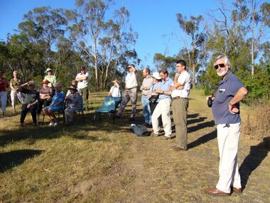
 Eltham District Historical Society Inc
Photograph, Dedication of Everard Memorial, Mt Everard, Kinglake National Park, 22 April, 2004, 22/04/2004
The Everard Memorial was officially dedicated on 22 April 2004 by Betty Lynch OAM, daughter of William Everard and sister of Blanche Shallard. Newsletter No. 156 May 2004 THE MT. EVERARD CONNECTION Mt Everard in the Kinglake National Park commemorates William Hugh Everard, State Member for Evelyn and father of our member Blanche Shallard who died some eighteen months ago. Doug and Gwen Orford represented the Society at the unveiling of an interpretive sign at Mt Everard. Doug has written this account of the event on 22nd April. We all travelled to Kinglake and met near the Fire Station where we were picked up by two buses provided by Parks Victoria to take us to the top of Mt Everard. There we enjoyed morning tea (needed to as we from·the first bus had to walk the last hill when the bus broke down) while we waited for the official party to arrive. While waiting we had a look at the open four sided interpretive feature donated by Mrs Betty Lynch OAM (sister of Blanche) in memory of their father Bill Everard who was the State Member for the area for many years and in recognition of Kinglake National Park's 75th birthday. The information display describes the Blue Ant Butterfly, the Coconut Ant and the Swamp Pea, all of which are indigenous to the area. The Chief Executive of Parks Victoria welcomed everyone on this warm windy day after which Betty explained how the blue ant butterfly cohabited with the ants and survived. The swamp pea is described as a rare indigenous plant to the area. She also spoke of her father's interest in the area. The Governor, John Landy, then spoke before he and Betty moved up to the display board and cut the red ribbon from around it.10 colour photographsbetty lynch, everard memorial, mt everard, kinglake national park, dedication, blanche shallard -
 Surrey Hills Historical Society Collection
Photograph, Grovedale Road Quarry in the 1920s - looking south, c1920
The quarry was part of John Butler Maling's property. He was one of the original settlers of the area and farmed the area between Weybridge Street and Whitehorse Road. Clay was quarried from part of this area and used to make the bricks used in the construction of his home, known as 'Ancyra'. This is still extant at the corner of Weybridge and James Streets. Maling grazed cows and used the quarry as a water source. He was the uncle of John Butler Maling, Mayor of Camberwell. He was married to Kate Conlon in 1882. They had 3 children: Silas Young, Alick and Zillah. Maling was born in c1829 in Shepreth, Cambridgeshire; he died in Surrey Hills on 9 October 1912 and is buried in Box Hill Cemetery - CE-*-0586. Mrs Kate Maling (born c1859 in Co Meath, Ireland) died at the property on 8 March 1921. She is buried in Brighton General Cemetery. Probate was valued at over 10,000 pounds and included other properties in Sandringham, Hawthorn and Macedon. At the time of her death the Surrey Hills property was described as being 23 acres with 2 brick houses, 1 cow, 2 heifers and 40 fowls or chickens. The property was subdivided after her death. The property was subdivided into 110 house blocks in c1923 - see Maling's Estate subdivision flyer on the State Library of Victoria's website. This shows that the Grovedale Park site had been acquired by Camberwell Council by this time. An attached newspaper clipping documents prices realised for a cross-section of blocks. The MMBW map of 1925, also on the SLV website, shows the outline of the clayhole / quarry. The quarry was filled in after several drownings or near drownings and the land is now occupied by a park and playground, known as Grovedale Road Park, maintained by the City of Boroondara. Beckett Park is sited on horizon to the left beyond the trees. This documents the landscape prior to close settlement and is material to early building and farming in the Surrey Hills area.Black and white photo of the quarry between Grovedale Road and James Street taken in the 1920s and looking south. In the foreground is an area of water with reeds in the LH corner. Beyond on the high banks there are single storey houses in the background and (?) some light poles. An object that looks like a tank on posts is in a cutting on the far bank.quarries, grovedale road, james street, clay quarries, farming, kate conlon, kate maling, john butler maling, ancyra -
 Wooragee Landcare Group
Photograph, 28th April 2004
This photograph was taken at Wooragee Hall on Wednesday the 28th of April 2004 called 'Queries about Quolls' and shows a Quoll Presentation by Andrew Murray at Mt Pilot, Chiltern Mt Pilot National Park. The photograph shows (L - R) Jerry Alexander, Unknown, Unknown, Mary Prowse, Tony Prowse. The event was hosted by the Wooragee Landcare Group and was led by Andrew Murray (of Parks Victoria), President of the South-East Forest Spotted-tailed Quoll Working Group and one of Victoria's leading authorities in quolls. As the name of the event would suggest, this session provided attendees with insight and general information on quolls, including the characteristics of quolls, the habitat of quolls and the techniques that can be used when searching for quolls which was part of a wider project aimed at protecting the endangered species of the tiger quoll, also known as the spotted-tailed quoll, an animal that once inhabited Mount Pilot-Chiltern National Park. This particular photo shows a group of attendees looking at a typical quoll nesting site in a rock crevice. According to an article included in the Wooragee Landcare group coordinators annual report 2004 and 2005 album (record 00001), Andrew Murray had been tasked to train a team of Department of Sustainability and Environment staff and volunteers from the local area (Beechworth and Wooragee) in the detection skills needed to establish whether the tiger quoll still inhabited the Mount Pilot-Chiltern National Park and had survived after a bush fire in 2003 had burned through the area where they would normally have been found. The Tiger Quoll is the largest of the quoll species. Largely resembling a cross between a possum and a cat, the quoll is distinctive due to the white spots that are often found all over its brown fur.This photograph is significant as it provides evidence of a project undertaken by the Wooragee Landcare Group to educate themselves and members of the public on the tiger quoll in the early 2000s in an attempt to better understand and protect the species. The Wooragee Landcare Group has been instrumental in the co-ordination of programs relating to biodiversity protection in the local area, providing great assistance to landholders.Landscape coloured photograph printed on gloss paperReverse: WAN NA 0ANA2N0 AN2 0 1636 / [PRINTED] (No.4) / 918wooragee, wooragee hall, wooragee landcare, wooragee landcare group, quoll, spotted-tailed quoll, tiger quoll, queries about quolls, south east forest spotted-tailed quoll working group, andrew murray quolls, mount pilot chiltern national park, quoll species, endangered quoll, andrew murray, beechworth, landcare group, mount pilot -
 Camperdown & District Historical Society
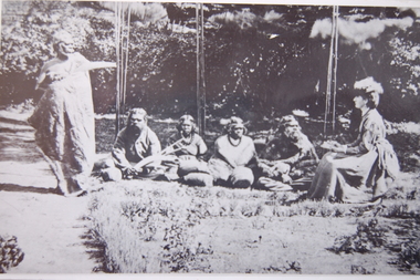
Photograph - Isabella Dawson with First Nations informants, c1865
Isabella Park Taylor, nee Dawson (1842-1929), friend of Western Victorian First Nations people, and student of their languages and customs. Isabella grew up at "Kangatong" (1844-1866) in the company of First Nations people and became fluent in their languages. With her father, James Dawson, she wrote the book "Australian Aborigines" (1881). Black and white photograph taken at "Kangatong", near Hawkesdale showing group of First Nations people in conversation with Isabella Dawson, seated on right with notebook in hand. Standing at left is Kaawirn Kuunawarn (also know as Hissing Swan and King David).James Dawson's daughter, Isabella, learning from the Aborigines on her father's station at "Kangatong" (From the original belonging to Miss M. Turner Shaw of S. Yarra. Copied by A.E. Jackson of Timboon.)cdhs, miss mary turner shaw, kaawirn kuunawarn, hissing swan, cdhsfirstnations -
 Camperdown & District Historical Society
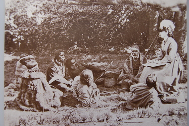
Photograph - Western District First Nations people with Isabella Dawson at 'Kangatong', c1865
Isabella Park Taylor, nee Dawson (1842-1929), friend of Western Victorian First Nations people, and student of their languages and customs. Isabella grew up at "Kangatong" (1844-1866) in the company of First Nations people and became fluent in their languages. With her father, James Dawson, she wrote the book "Australian Aborigines" (1881).Black and white photograph taken at "Kangatong", near Hawkesdale, of seven Western Victorian First Nations people all seated in conversation with Isabella Dawson, seated at right with notebook and pen in hand.cdhs, cdhsfirstnations -
 Warrnambool and District Historical Society Inc.
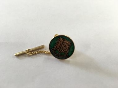
Ephemera - Badge, Warrnambool High School, c 1980
This is a Warrnambool High School badge . Warrnambool High School was established in 1907 and was housed in various locations around Warrnambool until 1961 when it moved into a purpose built building in Albert Park, Warrnambool . It merged with Warrnambool North Technical School to become Warrnambool College.in 1994..The badge is of superior quality and was probably given to visitors.This is retained as a memento of Warrnambool High School which was established over 100 years ago. A circular metal badge with gilt edging and the school emblem in black and gold on a green background.There is a stud clip at the back.and a a fob chain attached. WHS Nil Sine Labore Taiwan warrnambool high school, warrnambool, badge -
 Port of Echuca
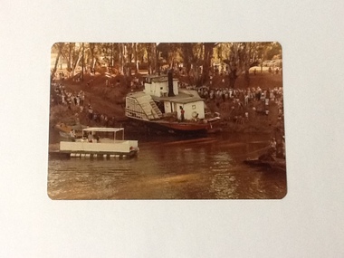
Colour Photograph, 04/03/1983
Colour photograph of P. S. Adelaide being encouraged down the soil ramp at Paddlewheel Park, onto the Murray river at Echuca. An outboard float is on the left with some spectators on it. Spectators line both sides of the ramp. Some kind of winching float is on the right. Part of photo sequence no. P000041; P000045; P000046; P000047; P000048.The re-floating of the P. S. Adelaide was a significant community social event evident by the number of spectators in the photograph. The community had invested a great deal of time and money into re-floating the paddlesteamer. The newspaper covered the event in detail with a number of action shots as the boat made its rear entry onto the Murray river.Colour photograph of P. S. Adelaide being encouraged down a soil ramp onto the river. An outboard float is on its left. Spectators line both sides of the ramp. Some kind of winching float is on the right.p. s. adelaide, echuca, re-floating p. s. adelaide -
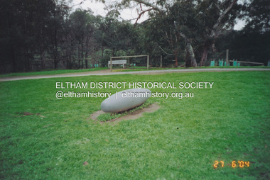 Eltham District Historical Society Inc
Photograph, Fay Bridge, Not Just a Pretty Place, Aleks Danko (2000), Lennister Farm, Eltham South, 27 June 2004
Not Just a Pretty Place, Aleks Danko (2000), Lennister Farm, Eltham South, c.2001 The sculpture was launched on 9th August 2000 by Cr Diane Bullen and welcomed by Annette Xiberras of the Wurundjeri community. Awarded the 2000 Nillumbik Art in Public Places Award and situated behind Lennister Farm near Yarra Parkfay bridge collection, 2004-06-27, aleks danko, art in public places, eltham south, lennister farm, not just a pretty place, public art -
 Greensborough Historical Society
Book, Nillumbik Shire Council, 1997 Community Guide Nillumbik, 1997_
Guide to services provided by Nillumbik Shire Council. Nillumbik Shire is located 25 kilometres north-east of Melbourne and the southern boundary is the Yarra River. The south of Nillumbik is predominantly urban, with commercial centres at Eltham and Diamond Creek. The north of the municipality includes significant natural features like Kinglake National Park and Sugarloaf ReservoirAnnual guide to services in Nillumbik. 64 pages. Cover is pale yellow with colour drawings. nillumbik shire council, handbooks -
 Greensborough Historical Society
Book, Nillumbik Shire Council, 1998 Community Guide Nillumbik, 1998_
Guide to services provided by Nillumbik Shire Council. Nillumbik Shire is located 25 kilometres north-east of Melbourne and the southern boundary is the Yarra River. The south of Nillumbik is predominantly urban, with commercial centres at Eltham and Diamond Creek. The north of the municipality includes significant natural features like Kinglake National Park and Sugarloaf ReservoirAnnual guide to services in Nillumbik 72 pages. Cover has white background and some 3-D artwork.nillumbik shire council, handbooks -
 Greensborough Historical Society
Book, Nillumbik Shire Council, 1999 Community Guide Nillumbik, 1999_
Guide to services provided by Nillumbik Shire Council. Nillumbik Shire is located 25 kilometres north-east of Melbourne and the southern boundary is the Yarra River. The south of Nillumbik is predominantly urban, with commercial centres at Eltham and Diamond Creek. The north of the municipality includes significant natural features like Kinglake National Park and Sugarloaf ReservoirAnnual guide to services in Nillumbik76 pages, illus. Cover has photographs of local people and title in white on orange background.nillumbik shire council, handbooks -
 Greensborough Historical Society
Book, Nillumbik Shire Council, Nillumbik Community Guide 2000/2001, 2000-2001
Guide to services provided by Nillumbik Shire Council. Nillumbik Shire is located 25 kilometres north-east of Melbourne and the southern boundary is the Yarra River. The south of Nillumbik is predominantly urban, with commercial centres at Eltham and Diamond Creek. The north of the municipality includes significant natural features like Kinglake National Park and Sugarloaf ReservoirAnnual guide to services in Nillumbik76 pages, black and white illustrations. Cover has a collage of local children with title in white on mid-blue background.nillumbik shire council, handbooks -
 Greensborough Historical Society
Photograph - Digital image, Happy Hollow plaque unveiling 1 and 2, 24/10/2006
Photograph of descendants of past owners of Happy Hollow preparing to unveil the commemorative plaque. Includes descendants of Charles Partington, John McLaughlin and Robert Emmett Whatmough. The land was later owned by Mrs Betty Bell and was purchased by Parks Victoria in 1994 to form part of the Plenty Gorge Parklands. This plaque was laid by Plenty Historical Society. Digital copy of colour photograph.happy hollow, robert emmett whatmough, charles partington, betty bell, parks victoria -
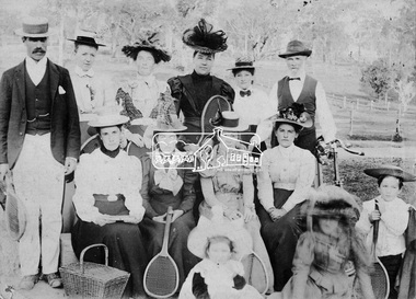 Eltham District Historical Society Inc
Photograph, Eltham tennis group
A group of nine women and two men (one holding a bike) and two children pose for a group photograph, some of whom are sitting. Five people hold tennis racquets and there is a picnic basket in the foreground. There are trees in the background. This group may or not be related to photos of the Eltham tennis courts located in what is now known as Wingrove Park.This photo forms part of a collection of photographs gathered by the Shire of Eltham for their centenary project book,"Pioneers and Painters: 100 years of the Shire of Eltham" by Alan Marshall (1971). The collection of over 500 images is held in partnership between Eltham District Historical Society and Yarra Plenty Regional Library (Eltham Library) and is now formally known as the 'The Shire of Eltham Pioneers Photograph Collection.' It is significant in being the first community sourced collection representing the places and people of the Shire's first one hundred years.Digital imagesepp, shire of eltham pioneers photograph collection, eltham, tennis, tennis players, wingrove park -
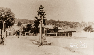 Eltham District Historical Society Inc
Photograph, Main Street, Greensborough, 1920s, 1920s
Looking towards the Plenty River from outside the current premises of the State Savings Bank. In the foreground is one of the old carbide street lamps. Behind the lamp is the drinking fountain erected as a memorial to Greensborough's Great War (First World War) Diggers. This memorial is now in the park in Henry Street, (Photo: Nillumbik Historical Society)Colour photograph copy originally located in a magnetic style album titled 'Greensborough Bypass 1990s 5' suffering significant degradation. No information contained in album or on reverse of photos except where noted. Relocated to archival photosafe storage.greensborough, main street -
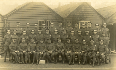 Federation University Historical Collection
Postcard, "A" Squad Cadets, St John's Wood Barracks, 1917
St John's Wood is a district of north-west London, in the City of Westminster, and at the north-west end of Regent's Park. The King's Troop, Royal Horse Artillery formerly resided at St John's Wood Barracks. The regiment moved to Woolwich on 6 February 2012; the barracks is to be demolished and developed as housing. (http://en.wikipedia.org/wiki/St_John's_Wood)A number of uniformed men pose for a photograph in front of a weatherboard building. The image is of the "A" Squad Cadets at St John's Wood Barracks, London.This card was purchased by an Australian soldier, probably Henry Smerdon Holmes, during World War One. Verso: "A" Squad Cadets. St John's Wood Barracks, London, 12th March 1917chatham family collection, chatham, world, war, world war one, world war 1, world war i, france, harry holmes, holmes, st john's wood -
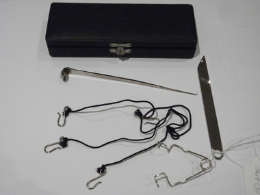 Royal Australian and New Zealand College of Obstetricians & Gynaecologists (RANZCOG)
Instrument case with unidentified instruments
Donated by Miss Beatrice May Devlin, items that belonged to her paternal grandfather, Dr Henry William Devlin who graduated in Medicine from Dublin and worked at the Rotunda hospital, Dublin. He immigrated to Australia and was the first doctor to practise in Parkes NSW.Please refer to supplementary file filed under Accession number 1995001Instrument case, small, containing small silver knife, a small silver ladel with a sharp probe at one end, a tweezeer like instument and string with three hook attachments. Looks unused, not gynaecological, nasal?dr henry william devlin -
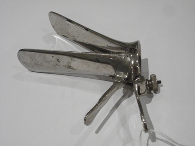 Royal Australian and New Zealand College of Obstetricians & Gynaecologists (RANZCOG)
Cusco's speculum used by Dr Henry William Devlin
Donated by Miss Beatrice May Devlin, items that belonged to her paternal grandfather, Dr Henry William Devlin who graduated in Medicine from Dublin and worked at the Rotunda hospital, Dublin. He immigrated to Australia and was the first doctor to practise in Parkes NSW.Please refer to supplementary file filed under Accession number 1995001Speculum, Cusco'. "10"stamped inot metal on base.dr henry william devlin -
 St Kilda Historical Society
Photograph, St Kilda Park Primary School Tower 2001 - images collection, 27 November 2001
The images show maintenance issues at St Kilda Park Primary School in 2001. The school was built in 1879. Former Governor General Sir Zelman Cowen, Archibald Prize-winning artist William Dargie, and test cricketers Bill Ponsford, Keith Miller and Ian Johnson, are among its well known former students.Colour photographsst kilda, st kilda park primary school, fitzroy street -
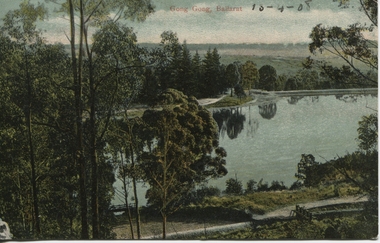 Ballarat Heritage Services
Photograph - Postcard, Gong Gong, Ballarat, 1908
Gong Gong was a locality in Ballarat East, near Fellmongers. A reservoir was built there. Situated only 10 minutes drive from the Ballarat CBD. In 2019 Gong Gong Reservoir Park is set in natural bush surrounds. There are scenics views, picnic and BBQ facilities with toilet facilities available on weekends. It is located along the Yarrowee River.photograph of Gong Gong reservoir 1908Gong Gong Ballarat - 13-4-1908 verso - note to Miss M I Wise, Gutheridge Parade, Salew. hewitt's yarrowee soap works, fellmongery, tannery, gong gong, mair street, daylesford road, o'deas, kinnane's, quin's, nestors -
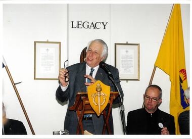 Melbourne Legacy
Photograph - Photo, Legacy meeting, 2002
Three photos of Sir Gus Nossal speaking at a Legacy Meeting in 2002. President Tony Parkes is seated on his left. Guests were invited speak at weekly Legacy luncheons. They came from a variety of backgrounds and spoke on many interesting and diverse topics. A register of guests was kept which can be seen at item 00837.A record that the speakers at Legacy meetings were from very different walks of life and the subjects spoken about were many and varied. Colour photo x 3 of Gus Nossal speaking at a Legacy function.speakers, legatee function -
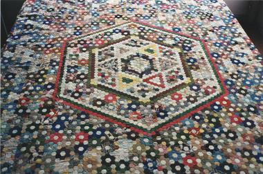 Kew Historical Society Inc
Decorative object - Large mid-Victorian silk patchwork quilt, 1850-1860
A silk patchwork quilt in a hexagons pattern originally owned by the Denbigh family of ‘Wimba’. The Denbigh family is recorded as living at ‘Park Villa’ ‘near Kew’ in 1856. John Denbigh was at this stage the superintendent of the local Baptist school. By 1869 they are listed as residing in Cotham Road. John Sharp Denbigh’s death in 1875 resulted in the sale of Wimba. This is an important early English silk hexagons quilt with outstanding technical workmanship, and is well-provenanced.The quilt is constructed in the popular hexagon pattern of silk off-cuts of an earlier period. Hexagon patchwork quilts were typically constructed of individual hexagons, which were formed using paper or card templates. Where these are visible, it would indicate that writing paper was used to form the templates. The quilt is unlined and has a green silk border, added at a later date. Early 19th Century patchwork quilts tended to use cotton to create the hexagons, whereas silk became the preferred medium mid-century. The quilt has been dated to the middle decades of the 19th century due to the colour range, and the exclusion of black silk hexagons. Most of the silk used in the quilt has a sheen, however there is some use of velvet in one or two larger hexagons. The exposed reverse of the quilt includes a large amount of very fine hand stitching.An unlined quilt was typically used as a summer spread. patchwork quilt, hexagon pattern, denbigh family, wimba, cotham road, kew, john denbigh, helen johnston, quilt, patchwork, textiles, migration to australia -
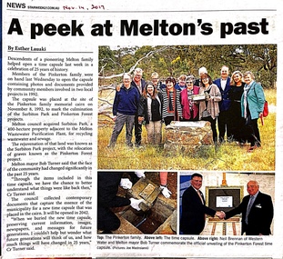 Melton City Libraries
Newspaper, A peek at Melton's past, 2017
Members of the Pinkerton family in November 2017 at the opening of the time capsule that was buried in 1992 to mark the rejuvenation of the land through the Surbiton Park and Pinkerton Forest projects. A time capsule was first buried in the memorial cairn marking the graves of members of the early settler family in 1931. A third time capsule was created in 2017, to be opened in 2042.Star Weekly article about the descendents of the Pinkerton familylocal identities, pioneer families -
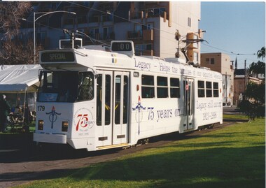 Melbourne Legacy
Photograph - Photo, Legacy Tram, 1998
Photo of a white tram painted to celebrate 75 years of Legacy work. As well as the 75 Legacy logo, it says "Legacy - Helps the families of our departed Veterans" and "75 years on ... Legacy still caring. 1923-1998" The tram is parked near a marquee, other photos show there were speeches and refreshments held there for the launch.A record of a way to promote Legacy during the anniversary in 1998.Colour photo of the launch of a tram painted to promote to Legacy's 75th Anniversary.legacy promotion, tram, 75th anniversary -
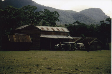 Halls Gap & Grampians Historical Society
Photograph - Coloured
The main building and chalets were built by E. C. Mitchell of Stawell. He was given a 99 year lease by the shire to build his holiday house at the site of Borough Huts. David and May Mitchell took over ownership of the house and chalets. The women in the photo are May and Isabel Mitchell and the man is David Mitchell. The chalets were called "Flappers Roost", "Bower of Innocence" and "Last Resort". The two copies of the photo are taken from slight closer in and are not as clear and do not show the entire third chalet.The photo shows a collection of old buildings. Two women are standing in front of a car and a man is standing a short distance from them. A second car is parked between the main building and the huts. The building to the far right of the photo is painted in a cream colour and has a tin chimney. The other buildings are three small huts or chalets. Gum trees and a mountain range can be seen directly behind the buildings.buildings, houses -
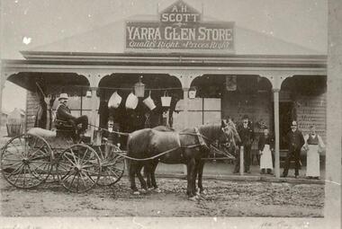 Yarra Glen & District Historical Society
Black and white photographs, A. H. Scott General Store Yarra Glen late 1890s
A.H.Scott Yarra Glen Store on the corner of Bell and King Streets in the late 1890s. Parked in front is a spring buggy with driver and two horses. On the buggy is a bag of produce. Five males are standing on the veranda one of whom is a policeman and two are store assistants. Buckets and tinware is hung from a line across the veranda. To the left hand side of the store, along King Street, can be seen two timber cottages.general store, buggy, a h scott, scott, yarra glen store, spring buggy, policeman, store assistants, tinware, cottages, timber cottages, workers cottages