Showing 9257 items matching " tree"
-
 Whitehorse Historical Society Inc.
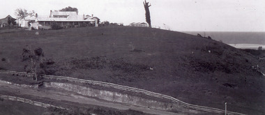
Article, A Bushland valley reclaimed
Article talking about the beginnings of Yarran Dheran, once used as a stone quarry and then a council tip. Nunawading Council and Blackburn & District Tree Preservation Society and local residents drew up plans to protect and restore what was left and create and reconstruct the rest of the bush gully.parks and reserves, yarran dheran, schwerkolt cottage, schwerkolt, albert, city of nunawading, blackburn and district tree preservation society -
 Whitehorse Historical Society Inc.
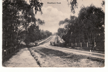
Postcard - Black and white postcard, Blackburn Road Circa 1908, C1914
Black and white postcard entitled 'Blackburn Road'. Scene shows bridge over unmade road and heavily treed sides. Looking north|Known as Halley's Bridge.|Demolished in 1965.|Blue stones from bridge used in garden of Lynette Letcher in Clovely Court Blackburn.blackburn road, blackburn, hooke, albert arthur, halley's bridge, bridges, letcher lynette -
 Southern Sherbrooke Historical Society Inc.
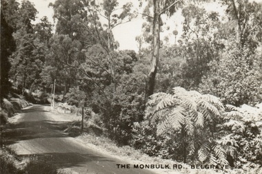
Postcard, The Monbulk Rd, Belgrave
Sepia-toned postcard showing Monbulk Rd, Belgrave, presumably heading towards Kallista. Road is unmade. Trees and ferns growing along side of the road. The ground slopes downhill from left to right. At a bend in the road a stretch of wooden barrier is visible near a gully. -
 Southern Sherbrooke Historical Society Inc.
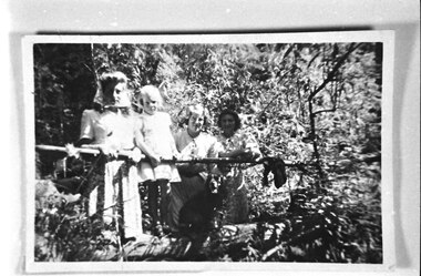
Photograph - Family at Fern Glade Track
Photograph of family group of four females (at least one of them a child) at Fern Glade Track near Mt. Morton, Belgrave Heights. The family appear to be holding on to a railing in a heavily treed area. Probably taken by Betty de Coite nee Woods or her parents. -
 Southern Sherbrooke Historical Society Inc.
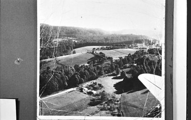
Photograph, Aerial view of Cotswold Valley
Aerial view of Cotswold Valley, Menzies Creek. B&W photos taken from light plane. Paddocks and treed areas are visible. Two houses are in the centre of the photo, presumably the Breen farmhouse on Jacksons Hill Road. The tip of the plane's left wing is also visible. -
 Southern Sherbrooke Historical Society Inc.
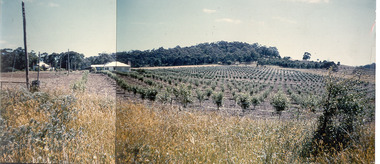
Photograph - Photo-colour- Montague apple orchard, 1954
Colour photograph of Bill and Stella Montague's original house with the orchard that was planted in 1952 in the foreground. The home of Alf and Marion Montague (Bill's parents) is on the left. A line on the left side indicates this is two photos stuck together to form a panorama. Trees in orchard appear to be quite young. -
 Bendigo Historical Society Inc.
Slide - DIGGERS & MINING: THE DIGGINGS - THE DIGGERS
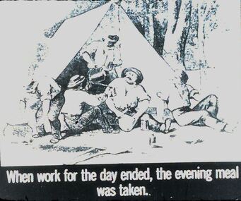
Diggers & Mining: The Digging - The Diggers. Slide depicts a dog and 5 men outside a tent with trees in the background. The slide reads; ‘When work for the day ended, the evening meal was taken'. Black and white side. Markings: 32 994.LIF:6. Used as a teaching aid.hanimounteducation, tertiary, goldfields -
 Bendigo Historical Society Inc.
Slide - DIGGERS & MINING. DIGGERS AND MINERS, c1800s
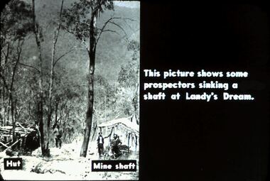
Diggers & Mining. Diggers and miners. Walhalla - Gold Town. This picture shows some prospectors sinking a shaft at Landy's Dream. Hut on left and mine shaft to the right. In this photo there are still many tall trees around. Markings: 11 995 WAL. Used as a teaching aid.hanimounteducation, tertiary, goldfields -
 8th/13th Victorian Mounted Rifles Regimental Collection
Photograph
In 1988, as part of a Defence of Mainland Australian policy, defence of facilities of strategic importance in northern Australia were allocated to Army Reserve units. ‘A’ Squadron was allocated the defence of Tindal Air Force base located 15 KM outside Katherine in Northern Territory. Consequently the Squadron deployed on Exercise ‘Northern Explorer’ to gain first-hand knowledge of operating conditions for mounted and dismounted patrolling in the area.Colour photograph of Captain C. Carrington, earing hat, and Sergeant Koschel of ' A ' Squadron 8/13 VMR during Exercise " Northern Explorer." Flood debris caught high in tree branches indicate water level during wet season on Ferguson River, Northern Territory. -
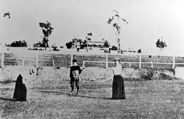 Surrey Hills Historical Society Collection
Photograph, Surrey Hills Golf Club eighth hole, 1902, 1902
Reproduced by permission of Mr John Arnold from his book: "The Riversdale Golf Club - a history, 1892-1977." Copyright to book: Riversdale Golf Club. Surrey Hills Golf Club operated from 1892-1908 then moved and became Riversdale Golf Club. The game was played across paddocks from Trafalgar Street, Mont Albert to Whitehorse Road and down Victoria Crescent to where Box Hill TAFE is now located in Elgar Road. There were problems with cows eating the tee flags! The clubhouse still exists as 30 Trafalgar Street. No 3 Beatty Street is in the background. The players are probably standing on what is now Zetland Road.This image is important not only for documentation of early sporting activities in the area but also for evidence of the pre-urban appearance of the landscape.Black and white photo with 2 ladies with golf clubs in the foreground and a lad (? caddy) with a golf bag under his arm. He is wearing a cap and 'plus fours'. The ladies are wearing long skirts, blouses and hats. Behind is a post-and-rail fence with a house and trees in the background.Caption: " Bottom: Putting out on the eighth hole, 1902."sports grounds, surrey hills golf club, riversdale golf club, clothing and dress, zetland road, surrey hills, john arnold -
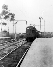 Surrey Hills Historical Society Collection
Photograph, Early electric train at Mont Albert Station, c1926, 1926
Date is approximate. Electric trains replaced steam locomotives in 1922. Mr William Holmes of 'Lugano', Mont Albert Road was in charge of the design and introduction of the electrification of the Melbourne rail system.Black and white photo of an early electric train approaching the platform at Mont Albert station. A couple of spindly eucalyptus trees can be seen beyond the picket fence marking the boundary of the platform.Black and white photo mounted on card; measures 16.3 cm x 23.4 cm.mont albert station, railways, trains, norman carter -
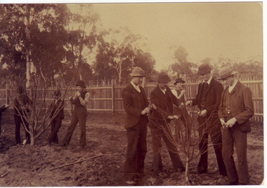 University of Melbourne, Burnley Campus Archives
Photograph - Sepia print, A.E. Bennett, Students Working in the Orchard, 1894-1990
Reproduced in "Green Grows Our Garden" by A. P. WinzenriedSepia photograph. Group of students holding secateurs surrounding 2 young apple trees. Note picket fence with barbed wire, later replaced with massive boxthorn hedge. Copy of sepia photograph in, "Prize Essays," Alfred E. Bennett, c.1894, p 108.students, apple trees, picket fence, barbed wire, prize essays, alfred e. bennett, boxthorn hedge, students working outside, green grows our garden, a p winzenried, secateurs, pruning -
 Lakes Entrance Historical Society
Photograph - Camping Park, Jemmeson Edie, 1928
This fully self contained camp park containing accommodation, general store, entertainment, Rotunda, petrol bowsers and community kitchen was the vision of Richard Bromby Whiter who commenced the project in 1927. Water for gardening and sewerage supplied by an underground boreSmall format black and white photograph of the entrance to the planned Lakes Camping Park fronting Roadknight Street. Shows homestead, cabin and tents, small tree in foreground, vehicle at side. Vera Wilson, later Vera Harbeck, standing outside entrance. Lakes Entrance Victoriatourism, recreation, camping, room display -
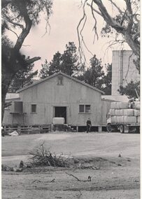 Linton and District Historical Society Inc
Photograph, Woolshed at Linton Park, 1983
Black and white photograph which has been mounted on white card. The photograph shows a corrugated iron woolshed, with a bale of wool sitting on the top of the entrance steps. A man is at the front to the woolshed, walking towards a truck loaded with wool bales. A grain silo and trees are in the background.linton park [agricultural property] -
University of Melbourne, Burnley Campus Archives
Newspaper - Newspaper Cutting, The Victorian Farmers Journal and Gardeners Chronicle, The New Gardens, 1861
Copy of article in "The Victorian Farmers Journal and Gardeners Chronicle" 26 October, 1861 p13 by 'Albany Country Gentlemen.' Description of the new Gardens of the Horticultural Society. Taxodium sempervirens donated by Mr Rule. Terraces in the ornamental garden already being planted up and trees planted.the victorian farmers journal and gardeners chronicle, victorian horticultural society, mr rule, taxodium sempervirens, californian redwood, terraces, planting -
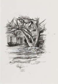
 Whitehorse Historical Society Inc.
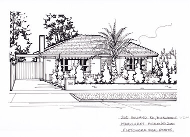
Artwork, other - Ink Line Drawing, 202 Holland Rd., Burwood E, 1994
A property illustration by Margaret Picken Commissioned by the real estate agency Fletchers Real Estate for the purpose of advertising 202 Holland Rd, Burwood East in 2001 Made by using Rotring ‘Rapidigraph’ drafting pens with Rotring ink on Rapidigraph polyester drafting film, double matte. Trained as a cartographic draftsman within the mining industry, Margaret Picken is an artist who worked producing property illustrations for real estate agencies in eastern suburbs of Victoria from 1983-2005. Retiring from the industry as technological changes favored coloured photography over illustrations, and commissioning companies over sole contractors.This artwork is of Historical Significance as a record of local domestic architecture.A black ink line drawing on drafters film by Margaret Picken, of 202 Holland Rd., Burwood East. A one story brick house, with a driveway leading to gated carport on the left. In the foreground is a low brick fence, and front lawn filled with hedges, and a large palm tree.202 Holland Rd., Burwood E. Margaret Picken © 2001 Fletchers Real Estatewhitehorse historical society, schwerkolt cottage, housing, architecture, margaret picken, burwood, house, garden, burwood east, palm tree -
 Linton and District Historical Society Inc
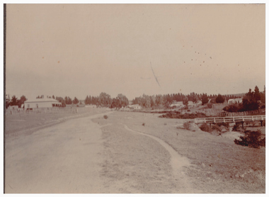
Photograph, Grey Street, Linton
Sepia photograph showing several houses along a dirt road open area with some trees, footbridge on RHS. Shire Engineer's house (formerly house owned by Hubert Adams, newspaper proprietor) is on corner of road to Devil's Kitchen. Glimpse of Murrell's Victoria Hotel in distance."Esther Cluff Linton".buildings, houses, shire of grenville engineer's house -
Glenelg Shire Council Cultural Collection
Photograph - Photograph - Framed of Henty landing re-enactment 1934, c. 1934
Framed black and white photo, Henty landing re-enactment 1934, during centenary celebrations. Six men in period costume, standing on beach, Union Jack flying from gum tree pole, dog in background. Photograph in deep, dark wooden carved frame.Back: Sticker: 'B. Vivian' -
 Tatura Irrigation & Wartime Camps Museum
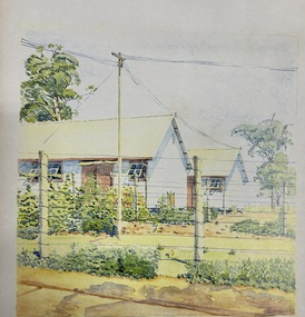
Painting - Painting - Water Colour, Camp 3, 1942
Original water colour painted by Glunkler an internee at Camp 3Hoefer Familywatecolour of camp 3. 2 half huts half obscured, 2 posts, 9 wire strand fence with an electric powerline. Tall gum tree left hand side, gardens. I. (Note : Glass windows had replaced fly wire by 1941 in the huts.) Glunkler 42painting, watercolour, huts, glunkler, hoefer family, camp 3, tatura, ww2 camp 3, illustrations -
 Lakes Entrance Historical Society
Photograph - Merrangbaur Hill, 1925c
Black and white photograph of Merrangbaur Hill, showing Merrangbaur House, and an old vine covered tree, which was a landmark for vessels at sea off the coast. Fenced off roadway at base of hill with water course alongside. Distant glimpse of surf and ocean. Lakes Entrance Victoriaguesthouses, roads and streets, topography, coast, fences -
 Bendigo Historical Society Inc.
Photograph - Napoleon Reef Gold Mine Battery Site, 1936
The Napoleon (BML) gold mine (1932) was located beside McDougall Road, Golden Gully, between Martin and Hattam Street. It had a depth of 921 feet. It was one of the latest and most lavish of Bendigo's mines. Plant and equipment were electrically driven. The four-compartment shaft, extra large by goldfield's standards, measured 17 feet 6 inches by 5 feet 2 inches and was cement lined below 900 feet instead of being red gum boxed as was the usual practice. The workshop was equipped to carry out all repairs for the equally lavish BML mines on the Nell Gwynne and Carshalton reefs. (The Gold Mines of Bendigo, Book 2, Arthur Victor Palmer)Significant to mining history of Bendigo.Black and white photograph. Image shows flat, open landscape with four large eucalypt trees in centre of image. Four men working with shovels on left hand side of image, one man with wheelbarrow and dog alongside. Wooden framed structure on right hand side. Written in pencil on back of photograph: ' Battery excavations started 22/9/36' and 'excavations started'.napoleon gold mine, napoleon reef gold mine -
 Federation University Historical Collection
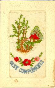
Postcard, Silk Embroidered World War One Postcard, c1917
Australian World War One Soldier memento. This postcard was possibly sent home from France during World War One, most probably from Harry Holmes of Ascot, Victoria. HENRY SMERDON (Harry) HOLMES was born in 1897 at the family property, ’Sauchieburn’, 17 km north of Ballarat, in the Ascot district. He was the youngest of four children. After finishing his education at St Patrick’s College, Ballarat, Henry joined the Holmes family farming interests. At the age of 18 he enlisted and served with AIF in Egypt, France and Belgium 1915-1918. Henry served at the famous battlegrounds of Ypes and Somme in the Australian Army 8th Battalion. He was a Driver with the 4th D.A.C. The postcard is of "The Ascot" boys. Includes [Samuel] Gordon Spittle, Henry [Harry] Holmes's first cousin, and other Ascot and Tourello lads and district connections: neighbours (including a Wrigley boy), Ascot State School classmates and football mates from Clunes / Creswick districts. (Research by Jane Dyer) Postcard with embroidered detail on white silk, with top flap. The central embroidery depicts two small soldiers dressed in brown outside a gate leading to house in a peaceful setting surrounded by trees. Below is a blue embroidered "Best Compliments" and red embroidered garland of red flowers.chatham family collection, chatham, world, war, world war one, world war 1, world war i, france, harry holmes, holmes, embroidery, postcard -
 Ballarat Tramway Museum
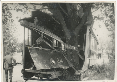
Photograph - Digital image, The Courier Ballarat, 1/12/1941
Digital image from the Wal Jack Ballarat Album of an accident involving Ballarat Tram No. 24 running away following a collision with a truck in Drummond St. South and hitting a tree at the corner of Dana St. on 1/12/1941. See also Reg Item 1348 for another photograph and more details. Wal's album notes "No. 24 crashed into tree result of a collision with a motor lorry, Intersection of Drummond and Dana Sts 1-2-41 (8am). Motorman T. Young unhurt. See image i2 for the rear of the photograph with extensive details - the print had been sent to Ken Magor by Wal. See image i3 for high res scan of album photograph. See image i4 for high res scan of negative - on a large format size neg.Yields information about the accident that involved a tram hitting a tree after being derailed and amount of damage done at the time.Set of digital images and a print on Velox paper.Written on rear in blue ink - "1-2-41" on Rear of print extensive details - see image i2trams, tramways, accidents, ballarat, drummond st, runaway, collision, tram 24 -
 Bayside Gallery - Bayside City Council Art & Heritage Collection
Work on paper - ink and watercolour, Annette Meikle, Chinese Elm - Corner Beach Road and Hampton Street, 1977
In 1977, artist Annette Meikle undertook a commission to illustrate a book recording stories of places and people in the Bayside area. It was published in 1978 as Sandringham Sketchbook, with text by Elizabeth Waters. The sketches were intended to record remaining examples of Bayside’s early architecture and environment, as well as reflect newer architectural changes. Meikle went on to donate 22 of these sketches to Bayside City Council in 2003. The Chinese Elm tree illustrated here marks the site of ‘Esmeralda’ which stood at at 312-314 Hampton Street, Hampton. It was a rambling house built in 1872 by Alfred William Harston and demolished in the 1970s. The elm is thought to be over 150 years old and was preserved by Council when flats were built on the site. It is recognised in the Significant Tree Register of Bayside City Council.Annette Meikle, Chinese Elm - Corner Beach Road and Hampton Street 1977, ink and watercolour, 33.8 x 23.7 cm. Bayside City Council Art and Heritage Collection. Donated by the artist, 2003annette meikle, sandringham sketchbook, elizabeth waters, chinese elm, esmeralda, alfred william harston, significant tree, historic house, hampton, hampton street -
 National Wool Museum
Acorn
Acorn and caps are from a 15 metre high Valonia oak tree (Quercus ithaburensis macrolepis) which was uprooted during a storm on Tuesday, 1st December 1987. The tree was planted in the Geelong Botanic Gardens by the first curator, Daniel Bunce, from an acorn shipped to Charles Ibbotson from Southern Europe in 1861. Ibbotson was the Chairman of the Management Committee of the Gardens and a woolbroker and merchant who founded the company Dalgety, Ibbotson and Co. with F.G. Dalgety in 1852. The acorns arrived in poor condition, but later established well. Very few Valonia Oaks were successfully propagated in Australia. Valonia oak caps were an important species which were used in the European tanning industry and Australian tanners were eager to grow the oak here.Five immature acorn caps from a Valonia oak, first planted in the Geelong Botanic Gardens in 1861 from acorns forwarded by Charles Ibbotson. Acorn and cap from a Valonia oak, first planted in the Geelong Botanic Gardens in 1861 from acorns provided by Charles Ibbotson. geelong botanic gardens dennys, lascelles limited city of greater geelong, tanning, valonia oak, ibbotson, mr a. charles, the heights, newtown, geelong. -
 Vision Australia
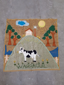
Image, Quilt squares
Vision Australia Foundation staff and clients were asked to make a square representing their base, which would be sewn together to represent the multi-faceted nature of the organisation. Unfortunately the patchwork wall hanging incorporating them was not made, however these squares were sent in: Warragul - sun and sunshine, clouds and water, a house on a hill with flowers around it, trees, water, people, a cow on a green hill that has daffodils and Pindari sewed upon it. Ballarat - Kelaston sown in same lettering as Ballarat, large fabric flowers with button centres, a mine head, a person panhandling, a person with a pickaxe. Warrnambool - sun and clouds over a seaside, a boat and whales in the water, a large fir tree and lighthouse. Hamilton - thick plaited stalks with fabric leaves and yellow pom poms as wattle. Digital imagevision australia foundation -
 Melbourne Legacy
Photograph - Legacy Week 2004, Event at the Shrine, 2004
An event at the Shrine of Remembrance Visitor Centre, the guests include some youths and Ron Barassi. Afterwards they posed for a photo in the Garden Courtyard. The president is George McKenzie. Ron Barassi participated in several Legacy events over the years. Ron was a a junior legatee after his father Ron Snr was killed in action at Tobruk in World War II, aged 27. From the film numbers see also 00686 and 00687. The Visitor Centre was completed in 2003 and provides unimpeded access for the elderly and disabled to the Sanctuary, the Crypt and the Galleries of Remembrance as well as open space for exhibitions and events. The courtyard has an olive tree as a centrepiece. This is the olive tree of peace that was planted by Legacy in 1973 to mark their golden jubilee. It was relocated to the new courtyard in 2002 when the Shrine was being redeveloped.A record of a ceremony at the Shrine for Legacy Week in 2004.Colour photo of the Legacy President George McKenzie with Ron Barassi and other dignitaries.Printed on the back "No.<10> Clarendon Photos 0556" which is the frame numbers and place of processing.legacy week, legacy promotion, george mckenzie -
 Glen Eira City Council History and Heritage Collection
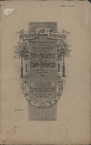
Booklet, D. W. Paterson Co. Pty. Ltd, "AVENUES OF HONOUR The Councils of the Municipalities of the CITY OF CAULFIELD TOWN OF BRIGHTON acting in conjunction PUBLIC DEMONSTRATION SAT 3rd AUG. 1918 AT 3oCLOCK SOUVENIR"
Souvenir Programme from the Councils of the Municipalities of the City of Caulfield and the Town of Brighton for a Public Demonstration to be held on Sat 3rd August 1918 at 3 o'clock for the proposed Avenues of Honour to be planted in memory of fallen WWI soldiers. One of two known copies, this copy has "Town Clerk" stamped in the upper corner, rhs.Commemorative booklet, grey cover with text printed on the grey textured paper and an image of four trees and a wreath. Image of a kookaburra on the back. Inside, 28 numbered pages with b/w text and photographic images including a transparent paper representation of the proposed Avenues of Honour on Brighton Road and Point Nepean Road. Souvenir programme for a Public Demonstration for the Avenues of Honour as detailed on the front. From Honour Roll Display 2019 interpretation panel - Brighton-Caulfield Avenue of Honour It is hard to imagine but a grand arboreal Avenue of Honour once lined parts of North Road, McMillan Street and Point Nepean Road (now Nepean Highway). The Avenue of Honour was a distinctly Australian phenomenon with hundreds being constructed throughout Australia during and following World War One, most of these in Victoria. Consisting of tree lined streets with each tree representing a solider, the Avenue of Honour signalled a more egalitarian approach to commemoration where rank was not a consideration. Arguably the most famous Avenue of Honour in Victoria still exists at Ballarat. Stretching for nearly 22 kilometres, the entrance to the Avenue is marked by the imposing Arch of Victory. Smaller in scale, the Brighton-Caulfield Avenue of Honour was dedicated to the ‘memory of (Brighton and Caulfield’s) kith and kin who came from (the) district and who died in the Great War’. A joint project between the neighbouring Councils, the idea was first reported in The Argus on 1 July 1918. Plans moved along quickly and on 3 August 1918 the Governor of Victoria Arthur Stanley planted the first Australian flowering gum. The next of kin were then invited to plant trees for lost sons, brothers, uncles, nephews and husbands. In all, over 400 trees were planted. Intensely personal, the Avenue also acted as a focus of grief and remembrance for the wider community. For many years, the annual civic Anzac Day service was held at the Avenue on Point Nepean Road, near Glen Huntly Road, Elsternwick. The service was moved to Caulfield Park upon the completion of the Cenotaph in 1930. Due to road widening and disease the last original tree was replaced in the 1980s, however a plaque in Caulfield Park records the Avenue’s plantation. Inkstamp upper corner rhs: "TOWN CLERK" -
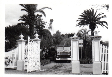 Williamstown Botanic Gardens- Hobsons Bay City Council
Photos - Cannons, 1970
The Armstrong Cannons were originally placed at Fort Gellibrand, located at the southernmost tip of the Williamstown peninsula. The Fort was developed during the 1850s as part of a defensive system for the city and port of Melbourne. The importance of the Fort batteries declined from the 1890s, when they were effectively replaced by new facilities at Queenscliff and Point Nepean, but they were still used for gunnery practice. Local residents, through the Williamstown Town Council, complained to the Acting Minister for Defence that the concussion from the guns damaged windows, walls and foundations of buildings. The Armstrong Cannons were moved from Fort Gellibrand to the Gardens in 1906. A primary source of evidence of the cannons being in the Gardens. The cannons are remembered fondly as play equipment for the local children. Many tales have been told of climbing over them and pretending to be shot out of them A collection of seven black and white photographs documenting the removal of the cannons from the Gardens Photo 1 (a) Black and white landscape image. View is looking through the main gates looking at the front of the truck, which has the name Walter Wright across the front bumper, the crane and canon. The gates and fence are painted a light colour, probably white. Photo 2 (b) Black and white landscape image. Back of loader with cannon on it. Man standing on top of the cannon bending over either tying or untying ropes. Trunk of a palm tree is on the left side of the photo with a top of a palm tree in the background. Photo 3 (c) Black and portrait white image. A cannon being loaded by the crane on to trailer. Palm tree is in the background and fronds from a palm tree can be seen in the right top corner. Photo 4 (d) Black and white landscape image. Side on view of a cannon on the truck parked outside the grounds of the Gardens. The logo of the name of the trucking company is on the door of the truck above the words ‘WALTER H WRIGHT / TRANSPORT PTY LTD / S SCHULZ ST WEST MELB’. A second cannon can be seen in the background. A bus is in the background on the middle right side of the image. Photo 5 (e) Black and white landscape image. Truck with cannon on the back leaving the ground of the Gardens. Tree on the right side of the image and power pole is behind the truck. The logo of the name of the trucking company is on the door of the truck above the words ‘WALTER H WRIGHT / TRANSPORT PTY LTD / S SCHULZ ST WEST MELB’. ‘WALTER WRIGHT’ is on the front bumper Photo 6 (f) Black and white landscape image. Cannon tied down on the back of the truck as it is being driven across the street. Three houses in the background and two cars, one is a Volkswagen Photo 7 (g) Black and white landscape image. Cannon on the back of the truck which is parked over the street from the Gardens. Three houses are in the background. Two trees bare of leaves. The front of a car in in the foreground – it has a sun visor and the steering wheel is a light colour.armstrong cannons, williamstown botanic gardens, hobsons bay city council, 1970, walter h wright / transport pty ltd -
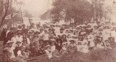 The Beechworth Burke Museum
Photograph, c. 1880
Taken in the 1880s, depicted is a large group of children and adults dressed in formal clothing picnicking upon the bank of Lake Kerferd. The five members of the group are holding union jack flags that have been hoisted upon portable flag poles. The group is seated by the lakeside in a grassed area beneath eucalyptus trees.This image was taken in the 1880s at Lake Kerferd. Lake Kerferd was created in 1862 to retain water for gold mining purposes from the Hurdle Swamp, and to additionally serve as Beechworth's main water supply. It was named after George Briscoe Kerferd, a Beechworth businessman and councillor, who later became the tenth Premier of Victoria.Sepia rectangular photograph printed on matte photographic paper mounted on boardentertainment album, picnic, lake kerferd, beechworth, burke museum, kerferd