Showing 757 items
matching 'mountain road
-
 Ringwood and District Historical Society
Literary work - Envelope, Packet: Letters and publicity - Ringwood area Publications
Letters about "25 Years of Paper" by E. Pullin; R.H.S.V. Newsletter - April 1984; "Mountain of Struggle" by John Lundy-Clarke -
 Ringwood and District Historical Society
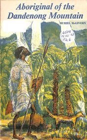
Book, Aboriginal of the Dandenong Mountain - Muriel McGivern
Story of the Aborigines whose hunting and cult sites lay about the foothills of the Dandenongs and the Upper Yarra River -
 Orbost & District Historical Society
black and white photograph, late 19th - early 20th century
This photograph was taken at the junction of the Snowy and Brodribb Rivers. The Snowy River starts in New South Wales on the slopes of Mt Kosciuszko, Australia’s highest mountain, in New South Wales. It flows into Bass Strait at Marlo in Victoria. The Brodribb River is a tributary of the Snowy which enters the estuary at Marlo. This is a pictorial record of a road in Marlo near Orbost in the late 19th-early 20th centuries. It also depicts the transport used at that time.A black / white photograph of four men in suits seated in a horse - drawn buggy on a dirt road alongside a creek or river. There appears to be another horse - drawn vehicle behind them.on back - "at the Brodribb - Snowy junction. this road was corduroy (packed logs of tea trees?)brodribb-river snowy-river marlo transport-horse-drawn -
 Ringwood and District Historical Society
Pamphlet, G.A. Green, Auction Sale Brochure - Garden Farms Estate, Ringwood, Victoria - 1919, 1919
... . Road shown as Bayswater Road to Bayswater became Mountain... Road Ringwood North melbourne Subdivison includes Canterbury ...Multi-fold brochure advertising public auction of one-acre, 2-acre, 5-acre and 8-acre allotments in Ringwood and Bayswater on Saturday 12th April, 1919. Brochure includes terms of sale, description of subdivision features and local facilities, and photographic images of the area.Subdivison includes Canterbury Road Heathmont, Armstrong Road Heathmont, Armstrong Road Bayswater, Bungalook Road Heathmont, Bungalook Road Bayswater, and Orchard Road Bayswater. Road shown as Bayswater Road to Bayswater became Mountain Highway Bayswater. Vendor: H.E.B.Armstrong, Auctioneers: Coghill & Haughton, 79 Swanston Street Melbourne, Telephone Central 2793, in conjunction with J.B. McAlpin, Ringwood, Opposite Station, Telephone Ringwood 7. (Map) Woodcock & McCormack, Civil Engineers Architects & Surveyors, 430 Little Collins Street, Melbourne, Phone 3241 Central. MOST OF THE MONEY COMES OUT OF THE LAND. And more money can be obtained from anb acre of fruit than from an acre of any other produce. But you do not have to grow fruit on Garden Farms Estate. You can go in for - Outer Suburban Home - Market Garden - Orchard - Pig Raising - Poultry Farm - Small Dairy Farm - Small Fruits - Floral Culture - Scent and Bee Farm - Or just for a Week-end Home. RINGWOOD - THE PLACE TO LIVE. The Beautiful Ringwood District has so many natural attractions, that half a Land Agent's work is done in just showing a prospective buyer round and about. Ringwood has a pull of its own that attracts folk, proved beyond doubt by its rapid development within the last decade (spite the war). First, it is high and healthy, picturesque and undulating, convenient of access, sufficiently close to the Metropolis for City and Business folk to live at Ringwood. Its development is solid, because most of its people are industrious husbandmen, real producers, who have turned idle hills into smiling gardens. These are the kind of real people to live amongst; ones who wear out their spades. The rapidly-developing town has excellent Stores, Trade and Repair Shops Churches, Banks, Telephone Exchange, Weekly General Market, Cool Stores, and good Private and State Schools, etc.; is Electrically lit, has Metropolitan Water Supply, and generally provides so that practically all shopping can be done locally. WHY RINGWOOD MUST GROW. Ringwood is a great centre and must be a greater. Two rapidly-developing railways junction here. The passengers from Ringwood Station cityward, in one year, number 250,000. Ringwood will be the terminus of the Outer Suburban Electric Eastern Railway. Its natural boundaries are the River Yarra on the North, Dandenong Creek on the South, the popular town of Croydon on the East, and the suburb of Mitcham on the West. This is a large territory that is steadily being converted from intense culture, and then it might be called (as regards its gardens) "The Devon Territory of Victoria." ARMSTRONG ROAD. This new road traverses Garden Farms Estate from its northern boundary on the main Canterbury Road, across Dandenong Creek, to its southern boundary on the main Bayswater Road, and will provide a long-desired additional link of communication between Bayswater and Ringwood. The 1-acre building sites on Bayswater Road are within 8 minutes' walk of the Bayswater Railway Station, and the Canterbury Road frontages are only 1-1/2 miles from Ringwood Station, and 1/2 mile from the Railway Station site of Canterbury Road; therefore, the whole Estate is easy of access and there should be a large demand for land so favourably placed. (Image) Cultivation Field - Potatoes on Lot 28 (Image) Picture of Bayswater Creek Flats. (Image) View from "Korumbeen" where Mr. Armstrong lived on Garden Farms Estate. Estate outlined in white ring. (Image) Site of New Bridge over Dandenong Creek. (Image) On one of the timbered lots adjoining railway. (Image) This Dandenong Creek traveres the Estate. (Image) Main Fern Tree Gully Line bisects the Estate. -
 Ringwood and District Historical Society
Photograph, Maroondah Highway Central, Ringwood. Main Street, looking west from Warrandyte Rd, c1924
Black and white photograph (2 copies- 1 large, 2 small) Typed below large photograph: "Main St looking west from Warrandyte Rd, c1924." Typed on back of one small photograph: "Coped from a circular for Mountain View Estate, J. Press, vendor, Second Av. Kew. In Mullum Rd, 90 yds from Oban Rd. Press, Rangeview & Mountview Avenues. Winnington just completed. 1924." -
 Ringwood and District Historical Society
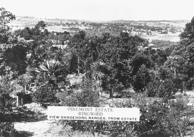
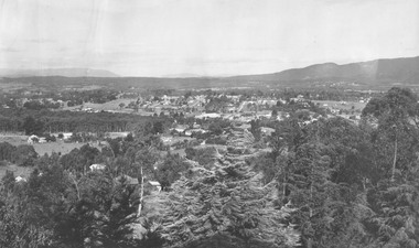
Photograph, Two images of view from Pinemont Estate, Loughnans Hill, looking east, c1930
Black and white photograph of view. Trees and bushes in foreground, orchards and mountains towards background. (2 copies)Typed on photograph, "Pinemont Estate, Ringwood. View Dandenong Ranges, from estate". Typed below photograph, "View from Loughnans Hill, looking east, c1930. Club Hotel can just be seen top right corner". -
 Ringwood and District Historical Society
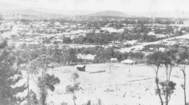
Photograph, View from Loughnan's Hill looking east c1930
Black and white photograph taken from vacant land on hill. Scene overlooks housing and trees. Mountains in background. (2 copies)Typed on photograph, "View looking east". Typed below photograph, "View from Loughnans Hill c1930. Maroondah Highway, Catholic church all top right corner". -
 Ringwood and District Historical Society
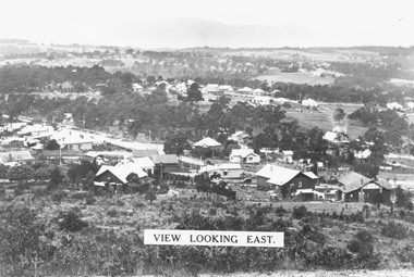
Photograph, View of Ringwood in 1912 taken from Loughnan's Hill
Black and white photograph looking across valley with small settlement. Mountains in background. (2 postcard copies and 2 enlargements). House in right foreground is in what is known now as Wildwood Grove. The dirt track above is Ringwood St. Field above is the football field with diagonal track coming out at Melbourne Street, later Eastland shopping complex. House on left is in Adelaide Street. Warrandyte Road is above it."Typed on back of one enlargement, "Copied from a postcard mailed in Ringwood, 1912, copied 1959. House in right foreground is in what is known now as Wildwood Grove. The dirt track above is Ringwood St. Field above is the present football field with diagonal track coming out at Melbourne Street. House on left is in Adelaide Street. Warrandyte Road is above it." House bottom RH side was still there in 1970 in Wildwood Grove (off Ringwood St). Ringwood Street lower centre to RH side. Field above Ringwood Street is the football field with diag. walk coming out at Melbourne Street. House on LH side in Adelaide Street. Warrandyte above it. Steam at LH from Bently's Steam Joinery at corner Main Street and Warrandyte Road. -
 Ringwood and District Historical Society
Photograph, A panorama of Ringwood from Mountain View Estate, Loughnan's Hill. (no date)
Typed below photograph, "A Panorama of Ringwood" and written on back of photograph, "Mountain View estate circular". -
 Ringwood and District Historical Society
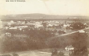
Photograph, Ringwood from Loughnans Hill. 1948
Black and white photograph taken from hill looking across valley towards settled area. Mountains in background. Catalogue card reads, "View from Loughnans Hill looking south east" -
 Ringwood and District Historical Society
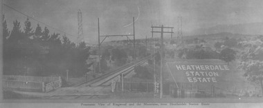
Photograph, View from where Heatherdale railway station is now situated, looking towards Ringwood - 2/2/1924. Land between Heatherdale Rd. and Madden St., sold 2nd Feb. 1924. J.B. McAlpin - agent"
Typed at bottom of photograph, "Panoramic view of Ringwood and the mountains, from Heatherdale Station Estate". Typed below photograph on mounting sheet, "View from where Heatherdale railway station is now looking towards Ringwood - 2/2/1924". "Between Heatherdale Rd. and Madden St., sold 2nd Feb. 1924. J.B. McAlpin - agent". -
 Ringwood and District Historical Society
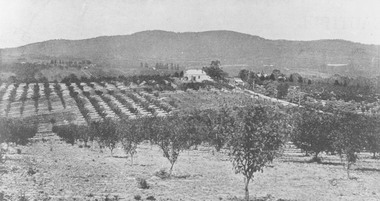
Photograph, View from Canterbury Road/Balfour Avenue area overlooking Martell's orchard, Heathmont, 1929
Black and white photograph of orchard. House in middle range, mountains in background. Photograph appears to be reproduced from subdivisional brochure. Note inserted in sleeve reads, "It has been pointed out that the mountains are to the east and the view is looking south. This therefore is not a 'straight' photograph. House still exists in Eden Avenue at October, 1996".(3 copies).Typed below photograph, "Panoramic view taken on the estate". "View overlooking Martell's orchard, Heathmont, 1929". Taken from corner Canterbury Rd. and Balfour Ave. looking south. Dandenong Creek just beyond house. Washusen Rd. on right". Written on back of one of the copies, "Heathmont Station Estate 1922". "Station Street, Lisgoold St. Canterbury Rd. Vivienne Cres. Balfour Ave." -
 Ringwood and District Historical Society
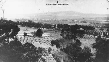
Photograph, View of Ringwood from Loughnans Hill. Pollards tank stand (centre) is on south side of Warrandyte Road. (Later location of Lauriston Crt.)
Black and white photograph looking down on orchards. House in centre of photograph, mountains in background. (3 copies)Written on back of one photograph, "Pollards tank stand" (centre) -
 Ringwood and District Historical Society
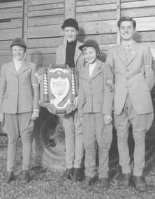
Photograph, The Mountain District Horse and Pony Club(undated)
Catalogue card reads, "The Mountain District Horse and Pony Club's winning team with the shield presented by the A.N.Z. Bank. From left: Judith Byrne, Helen Harvie, Marian Farmer, Campbell Sullivan". Note on back of photograph reads, "Annual two day competition of the Pony Clubs' Association of Victoria held at Frankston 21st and 22nd May. [no year stated]. -
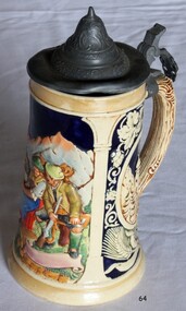 Flagstaff Hill Maritime Museum and Village
Ceramic - Beer Stein, Reinhold Merkelbach, 1945 to 1964
This mug was made by Reinhold Merkelbach. Reinhold Merkelbach was founded in 1845 by Wilhelm Merkelbach, a descendent of a long line of German potters, and the company eventually took the name of his son Wilhelm Reinhold Merkelbach, who left school early to get involved with the family business. The company became a major name in German ceramics, especially in the Jugendstil style. The company produced a large number of collectable beer steins in the late 18th and early 19th centuries, including a number of so-called “character steins.” In 1882, the firm began producing art pottery, which at that time was enjoying a revival and new appreciation in Europe in general and in Germany in particular. Reinhold Merkelbach produced ceramic objects both with and without pewter hardware but rarely altered its manufacturing techniques. Many of its products were destined for use at pubs, bars, or breweries as well as in the homes of Germany’s beer-drinking populace. It had a retail location in Munich and also sold products through its factory warehouse. In 1971, half of the company’s ownership was sold to W. Goebel KG and the firm’s name changed officially to Merkelbach Manufaktur GmbH & Co. KG. Goebel ultimately purchased the other half of the business before members of the Merkelbach family, along with a handful of collectors and former staff members, repurchased the factory in 1988. In 2007, Judith Merkelbach Engelmann decided to close the firm; demand for ceramics had been decreasing and the next generation of the family had no interest in maintaining the business. Luckily, Reinhold Merkelbach transferred its moulds to Töpferei Girmscheid Höhr-Grenzhausen to ensure that its best-known pieces of Jugendstil art pottery and steins would continue to be available to interested consumers and collectors.This beer stein was made around the mid-20th century by a popular German maker. It fits in with the context of maritime village life. At this current time, there is no particular connection with people, places and events. The German beer stein is made from ceramic ironstone. It has a bell-shaped hinged pewter lid with a leaf-shaped thumb lever. The lid has a pattern stamped on it. The design on the mug includes a woman in bright colours, a man holding a musket, and buildings in mountain settings. There are inscriptions on the mug. Marked "Made in Germany" "RM" "4070" (underside of mug) "05" to the side of mug flagstaff hill, warrnambool, shipwrecked coast, flagstaff hill maritime museum, maritime museum, shipwreck coast, flagstaff hill maritime village, great ocean road, beer stein, ceramic beer stein, reinhold merkelbach, drinking vessel -
 Marysville & District Historical Society
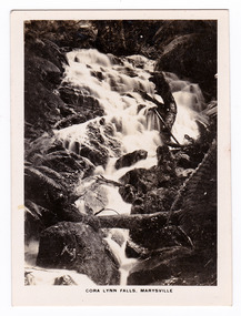
Photograph (item) - Black and white photograph, Rose Stereograph Company, Track to Cora Lynn Falls, Marysville, 1913-1967
An early black and white photograph of the track to the Cora Lynn Falls in Marysville, Victoria.An early black and white photograph of the track to the Cora Lynn Falls in Marysville in Victoria. These falls are located on the Marysville-Wood's Point Road. Cambarville is notable for its giant mountain ash (Eucalyptus regnans) trees within the Cumberland Memorial Scenic Reserve, and relics from former sawmills and gold mining. The Big Culvert is located nearby on the Marysville - Woods Point Road, which was historically part of the Yarra Track. Cambarville was established as a timber mill town in the 1940s. Timber mill owners A Cameron and FJ Barton named Cambarville. They established the mill to salvage timber from trees destroyed in the 1939 bushfires. Cambarville was impacted by the 2009 Black Saturday bushfires and any remaining structures were destroyed. The photograph was also used to produce the Rose Series postcard P. 4958.marysville, victoria, photograph, cora lynn falls, waterfalls, p. 4958, rose series postcard, rose stereograph company, souvenir, cambarville, marysville-wood's point road, eucalyptus regnans, cumberland memorial scenic reserve, mining, big culvert, yarra track, a cameron, fj barton, 1939 bushfires, 2009 black saturday bushfires, timber mills -
 Marysville & District Historical Society
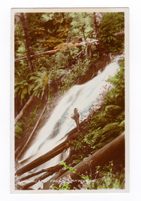
Photograph (item) - Black and white photograph, Rose Stereograph Company, Cora Lynn Falls, Marysville, 1913-1967
An early black and white photograph of the Cora Lynn Falls near Marysville in Victoria.An early black and white photograph of the Cora Lynn Falls near Marysville in Victoria. These falls are located on the Marysville-Wood's Point Road. Cambarville is notable for its giant mountain ash (Eucalyptus regnans) trees within the Cumberland Memorial Scenic Reserve, and relics from former sawmills and gold mining. The Big Culvert is located nearby on the Marysville - Woods Point Road, which was historically part of the Yarra Track. Cambarville was established as a timber mill town in the 1940s. Timber mill owners A Cameron and FJ Barton named Cambarville. They established the mill to salvage timber from trees destroyed in the 1939 bushfires. Cambarville was impacted by the 2009 Black Saturday bushfires and any remaining structures were destroyed. The photograph was also used to produce the Rose Series postcard P. 4947.marysville, victoria, photograph, cora lynn falls, waterfalls, rose series postcard, rose stereograph company, souvenir, cambarville, marysville-wood's point road, eucalyptus regnans, cumberland memorial scenic reserve, mining, big culvert, yarra track, a cameron, fj barton, 1939 bushfires, 2009 black saturday bushfires, timber mills, p. 4947 -
 Marysville & District Historical Society
Photograph (item) - Colour tinted photograph, Valentine Publishing Co. Pty. Ltd, The Road to Cumberland Valley, Marysville. No. 1, 1923-1963
... drays, and wagons. Today this sealed mountain road is a popular ...An early colour tinted photograph of the intersection of the Buxton Marysville Road and the Marysville-Wood's Point Road.An early photograph of the Buxton Marysville Road and the Marysville-Wood's Point Road intersection. The Marysville-Buxton Road joins the Maroondah Highway which leads to Alexandra. The Marysville-Woods Point Road was originally part of the Yarra Track, constructed in the early 1860s to provide access between Healesville and the Woods Point Goldfields. Despite the steep terrain and engineering difficulties, the Yarra Track soon became a busy route used by pack horses, horse-drawn drays, and wagons. Today this sealed mountain road is a popular scenic drive between Marysville and Warburton. On the right of the photograph can be seen 'The Crossways Hotel' which is circa 1920 and one of the oldest buildings still standing in Marysville. 'The Crossways Hotel' survived the 2009 Black Saturday bushfires, through the efforts of the owner using buckets of water from the nearby Steavenson River. In the background can be seen the Poontawan Guest House which later became the Marysville Chalet Guest House which was on the site of the original Steavenson's Hotel. That guest house no longer exists and the Christ Church stands on the land where the guest house once stood. This photograph was published by the Valentine Publishing Co Pty. Ltd as a souvenir of Marysville.marysville, victoria, marysville chalet guest house, crossways hotel, christ church marysville, poontawan guest house, steavenson's hotel, valentine publishing co, souvenir, yarra track, wood's point road, mining, buxton-marysville road, marysville-wood's point road, maroondah highway, alexandra -
 Marysville & District Historical Society
Photograph (item) - Colour tinted photograph, Valentine Publishing Co. Pty. Ltd, Cumberland Falls, Marysville. No.3, 1923-1963
An early colour tinted photograph of the Cumberland Falls near Marysville in Victoria. This photograph was published by the Valentine Publishing Co Pty. Ltd. as a souvenir of Marysville.An early colour tinted photograph of the Cumberland Falls near Marysville in Victoria. These falls are located on the Marysville-Wood's Point Road. Cambarville is notable for its giant mountain ash (Eucalyptus regnans) trees within the Cumberland Memorial Scenic Reserve, and relics from former sawmills and gold mining. The Big Culvert is located nearby on the Marysville-Woods Point Road, which was historically part of the Yarra Track. Cambarville was established as a timber mill town in the 1940s. Timber mill owners A Cameron and FJ Barton named Cambarville. They established the mill to salvage timber from trees destroyed in the 1939 bushfires. Cambarville was impacted by the 2009 Black Saturday bushfires and any remaining structures were destroyed.cumberland falls, waterfalls, marysville, victoria, valentine publishing co, souvenir, a cameron, fj barton, cambarville, marysville-wood's point road, eucalyptus regnans, big culvert, yarra track, timber milling, 1939 bushfires, black saturday bushfires -
 Marysville & District Historical Society
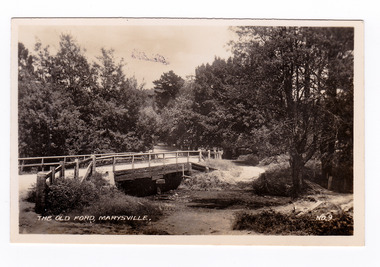
Photograph (item) - Black and white photograph, Valentine Publishing Co. Pty. Ltd, The Old Ford, Marysville No.9, 1923-1963
... this sealed mountain road is a popular scenic drive between Marysville ...An early black and white photograph of the old ford in Marysville, Victoria.An early photograph of the bridge at the end of the main street in Marysville which is near the Buxton-Marysville Road and the Marysville-Wood's Point Road intersection. The Marysville-Buxton Road joins the Maroondah Highway which leads to Alexandra. The Marysville-Woods Point Road was originally part of the Yarra Track, constructed in the early 1860s to provide access between Healesville and the Woods Point Goldfields. Despite the steep terrain and engineering difficulties, the Yarra Track soon became a busy route used by pack horses, horse-drawn drays, and wagons. Today this sealed mountain road is a popular scenic drive between Marysville and Warburton. This photograph was published by the Valentine Publishing Co Pty. Ltd as a souvenir of Marysville.marysville, victoria, valentine publishing co, souvenir, buxton-marysville road, marysville-wood's point road, maroondah highway, alexandra, yarra track, mining -
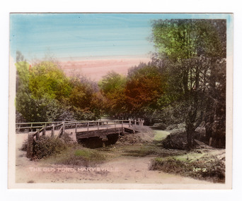 Marysville & District Historical Society
Photograph (item) - Colour tinted photograph, Valentine Publishing Co. Pty. Ltd, The Old Ford, Marysville No.9, 1923-1963
... , and wagons. Today this sealed mountain road is a popular scenic drive ...An early colour tinted photograph of the old ford in Marysville, Victoria. This photograph was published by the Valentine Publishing Co Pty. Ltd. as a souvenir of Marysville.An early photograph of the bridge at the end of the main street in Marysville which is near the Buxton-Marysville Road and the Marysville-Wood's Point Road intersection. The Marysville-Buxton Road joins the Maroondah Highway which leads to Alexandra. The Marysville-Woods Point Road was originally part of the Yarra Track, constructed in the early 1860s to provide access between Healesville and the Woods Point Goldfields. Despite the steep terrain and engineering difficulties, the Yarra Track soon became a busy route used by pack horses, horse-drawn drays, and wagons. Today this sealed mountain road is a popular scenic drive between Marysville and Warburton. This photograph was published by the Valentine Publishing Co Pty. Ltd as a souvenir of Marysville.marysville, victoria, valentine publishing co, souvenir, buxton-marysville road, marysville-wood's point road, maroondah highway, alexandra, yarra track, mining -
 Marysville & District Historical Society
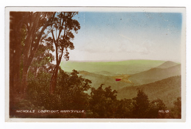
Photograph (item) - Colour tinted photograph, Valentine Publishing Co. Pty. Ltd, Nicoll's Lookout, Marysville No.10, 1923-1963
... , and wagons. Today this sealed mountain road is a popular scenic drive ...An early colour tinted photograph of Nicholl's Look-out near Marysville in Victoria. This photograph was published by the Valentine Publishing Co Pty. Ltd. as a souvenir of Marysville.An early colour tinted photograph of Nicholl's Look-out near Marysville in Victoria. This lookout is situated on the Marysville-Wood's Point Road. The Marysville-Woods Point Road was originally part of the Yarra Track, constructed in the early 1860s to provide access between Healesville and the Woods Point Goldfields. Despite the steep terrain and engineering difficulties, the Yarra Track soon became a busy route used by pack horses, horse-drawn drays, and wagons. Today this sealed mountain road is a popular scenic drive between Marysville and Warburton. This photograph was published by the Valentine Publishing Co Pty. Ltd. as a souvenir of Marysville.marysville, victoria, valentine publishing co, souvenir, nicholl's look-out, mining, yarra track -
 Marysville & District Historical Society
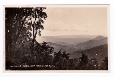
Photograph (item) - Black and white photograph, Valentine Publishing Co. Pty. Ltd, Nicoll's Lookout, Marysville No.10, 1923-1963
... drays, and wagons. Today this sealed mountain road is a popular ...An early black and white photograph of Nicholl's Look-out near Marysville in Victoria.An early black and white photograph of Nicholl's Look-out near Marysville in Victoria. This lookout is situated on the Marysville-Wood's Point Road. The Marysville-Woods Point Road was originally part of the Yarra Track, constructed in the early 1860s to provide access between Healesville and the Woods Point Goldfields. Despite the steep terrain and engineering difficulties, the Yarra Track soon became a busy route used by pack horses, horse-drawn drays, and wagons. Today this sealed mountain road is a popular scenic drive between Marysville and Warburton. This photograph was published by the Valentine Publishing Co Pty. Ltd. as a souvenir of Marysville.marysville, victoria, valentine publishing co, souvenir, nicholl's look-out, mining, yarra track -
 Marysville & District Historical Society
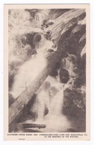
Postcard (item) - Black and white postcard, Rose Stereograph Company, Cumberland-Cora Lynn Trip, Marysville, Vic. At the Meeting of the Waters, 1913-1967
A postcard in a series produced by the Rose Stereograph Company in Victoria, Australia.A black and white photograph of the Cora-Lynn waterfalls at the Meeting of the Waters near the Cumberland Creek. These falls are located on the Marysville-Wood's Point Road. Cambarville is notable for its giant mountain ash (Eucalyptus regnans) trees within the Cumberland Memorial Scenic Reserve, and relics from former sawmills and gold mining. The Big Culvert is located nearby on the Marysville-Woods Point Road, which was historically part of the Yarra Track. Cambarville was established as a timber mill town in the 1940s. Timber mill owners A Cameron and FJ Barton named Cambarville. They established the mill to salvage timber from trees destroyed in the 1939 bushfires. Cambarville was impacted by the 2009 Black Saturday bushfires and any remaining structures were destroyed. This postcard was produced by the Rose Stereograph Company as a souvenir of Marysville.POST CARD. Correspondence/ Addresscora lynn falls, waterfalls, cumberland valley, cumberland creek, marysville, victoria, southern cross series, 4938, postcard, souvenir, meeting of the waters, marysville-wood's point road, cambarville, eucalyptus regnans, big culvert, cumberland memorial scenic reserve, a cameron, fj barton, 1939 bushfires, 2009 black saturday bushfires, rose stereograph company -
 Marysville & District Historical Society
Postcard (item) - Black and white postcard, Valentine Publishing Co. Pty. Ltd, View From Jock's Lookout, Marysville. V. 21, 1923-1963
... is situated on the Marysville-Wood's Point Road. The Marysville-Woods ...An early black and white photograph of the view from Jock's Lookout of Marysville in Victoria. An early black and white photograph of the view from Jock's Lookout of Marysville in Victoria. Jock's Lookout is situated on the Marysville-Wood's Point Road. The Marysville-Woods Point Road was originally part of the Yarra Track, constructed in the early 1860s to provide access between Healesville and the Woods Point Goldfields. Despite the steep terrain and engineering difficulties, the Yarra Track soon became a busy route used by pack horses, horse-drawn drays, and wagons. Today this sealed mountain road is a popular scenic drive between Marysville and Warburton. This postcard was published by the Valentine Publishing Co. Pty. Ltd. as a souvenir of Marysville.VALENTINE'S/ POST CARD/ A GENUINE PHOTOGRAPHjock's lookout, marysville, victoria, postcard, valentine publishing co, souvenir, marysville-wood's point road, yarra track, mining, warburton -
 Marysville & District Historical Society
Postcard (item) - Black and white postcard, Valentine Publishing Co. Pty. Ltd, View From Jock's Lookout, Marysville. V. 21, 1923-1963
... is situated on the Marysville-Wood's Point Road. The Marysville-Woods ...An early black and white photograph of the view from Jock's Lookout of Marysville in Victoria.An early black and white photograph of the view from Jock's Lookout of Marysville in Victoria. Jock's Lookout is situated on the Marysville-Wood's Point Road. The Marysville-Woods Point Road was originally part of the Yarra Track, constructed in the early 1860s to provide access between Healesville and the Woods Point Goldfields. Despite the steep terrain and engineering difficulties, the Yarra Track soon became a busy route used by pack horses, horse-drawn drays, and wagons. Today this sealed mountain road is a popular scenic drive between Marysville and Warburton. This postcard was published by the Valentine Publishing Co. Pty. Ltd. as a souvenir of Marysville.VALENTINE'S/ POST CARD/ A GENUINE PHOTOGRAPHjock's lookout, marysville, victoria, postcard, valentine publishing co, souvenir, marysville-wood's point road, yarra track, mining, warburton -
 Marysville & District Historical Society
Postcard (item) - Black and white postcard, Valentine Publishing Co. Pty. Ltd, View From Nicholl's Lookout, Marysville. V. 43, 1923-1963
... this sealed mountain road is a popular scenic drive between Marysville ...An early black and white photograph of the view of Marysville in Victoria taken from Nicholl's Lookout.An early black and white photograph of the view of Marysville in Victoria taken from Nicholl's Lookout. This lookout is situated on the Marysville-Wood's Point Road. The Marysville-Woods Point Road was originally part of the Yarra Track, constructed in the early 1860s to provide access between Healesville and the Woods Point Goldfields. Despite the steep terrain and engineering difficulties, the Yarra Track soon became a busy route used by pack horses, horse-drawn drays, and wagons. Today this sealed mountain road is a popular scenic drive between Marysville and Warburton. This postcard was published by the Valentine Publishing Co Pty. Ltd. as a souvenir of Marysville.VALENTINE'S/ POST CARD/ A GENUINE PHOTOGRAPHmarysville, nicholl's lookout, victoria, postcard, valentine publishing co, souvenir -
 Marysville & District Historical Society
Photograph (item) - Black and white photograph, Valentine Publishing Co. Pty. Ltd, Camberville Township, Near Marysville. V. 35, 1923-1963
An early black and white photograph of the township of Cambarville near Marysville in Victoria.An early black and white photograph of the township of Cambarville near Marysville in Victoria. Cambarville is notable for its giant mountain ash (Eucalyptus regnans) trees within the Cumberland Memorial Scenic Reserve, and relics from former sawmills and gold mining. The Big Culvert is located nearby on the Marysville-Woods Point Road, which was historically part of the Yarra Track. Cambarville was established as a timber mill town in the 1940s. Timber mill owners A Cameron and FJ Barton named Cambarville. They established the mill to salvage timber from trees destroyed in the 1939 bushfires. Cambarville was impacted by the 2009 Black Saturday bushfires and any remaining structures were destroyed. This photograph was produced by Valentine Publishing Co as a souvenir of Marysville.marysville, victoria, photograph, valentine publishing co, souvenir, cambarville, cumberland valley, cumberland scenic reserve, big culvert, marysville-wood's point road, yarra track, a cameron, fj barton, 1939 bushfires, 2009 black saturday bushfires -
 Marysville & District Historical Society
Photograph (item) - Black and white photograph, Valentine Publishing Co. Pty. Ltd, Camberville Township, Near Marysville. V. 35, 1923-1963
An early black and white photograph of the township of Cambarville near Marysville in Victoria.An early black and white photograph of the township of Camberville near Marysville in Victoria. Cambarville is notable for its giant mountain ash (Eucalyptus regnans) trees within the Cumberland Memorial Scenic Reserve, and relics from former sawmills and gold mining. The Big Culvert is located nearby on the Marysville-Woods Point Road, which was historically part of the Yarra Track. Cambarville was established as a timber mill town in the 1940s. Timber mill owners A Cameron and FJ Barton named Cambarville. They established the mill to salvage timber from trees destroyed in the 1939 bushfires. Cambarville was impacted by the 2009 Black Saturday bushfires and any remaining structures were destroyed. This photograph was produced by Valentine Publishing Co as a souvenir of Marysville.marysville, victoria, photograph, valentine publishing co, souvenir, cambarville, cumberland valley, cumberland scenic reserve, big culvert, marysville-wood's point road, yarra track, a cameron, fj barton, 1939 bushfires, 2009 black saturday bushfires -
 Marysville & District Historical Society
Photograph (item) - Black and white photograph, Murray Views, Murray Views No. 47. Nicholl's Lookout, Marysville, Vic, Post 1929
... is situated on the Marysville-Wood's Point Road. The Marysville-Woods ...An early black and white photograph of the view of Marysville taken from Nicholl's Lookout.An early black and white photograph of the view of Marysville taken from Nicholl's Lookout. Nicholl's Lookout is situated on the Marysville-Wood's Point Road. The Marysville-Woods Point Road was originally part of the Yarra Track, constructed in the early 1860s to provide access between Healesville and the Woods Point Goldfields. Despite the steep terrain and engineering difficulties, the Yarra Track soon became a busy route used by pack horses, horse-drawn drays, and wagons. Today this sealed mountain road is a popular scenic drive between Marysville and Warburton. This photograph was produced by Murray Views in Gympie, Queensland as a souvenir of Marysville. nicholl's lookout, marysville, victoria, photograph, murray views, souvenir, marysville-wood's point road, yarra track, mining, warburton