Showing 815 items matching " aerial views"
-
 Glenelg Shire Council Cultural Collection
Photograph - Photograph - Aerial view of CSR Softwoods plant, Portland, c. 1974
... Photograph - Aerial view of CSR Softwoods plant, Portland.... Photograph Photograph - Aerial view of CSR Softwoods plant, Portland ...Port of Portland CollectionFront: (no inscriptions) Back: (no inscriptions)port of portland archives, aerial photography, portland harbour -
 Montmorency–Eltham RSL Sub Branch
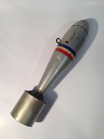
Weapon - Bomb, Aerial Practice
The 11 Pound Practice Bomb was used in Australia to train air crews both during and after WW2. When the bomb hit the ground it produced a smoke cloud so that the aircrew could see where their bomb had landed. There was only a small explosive charge in them. Cylindrical, finned steel bomb weighing approx. 11lb painted silver with three stripes (blue, yellow, red) painted around the mid-section. One attachment point/loop. Cast iron nose. None. -
 Phillip Island and District Historical Society Inc.
Photograph, Bryant West
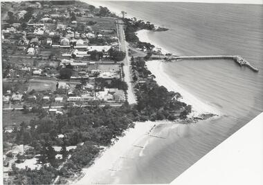
... aerial view of cowes phillip island... foreshore foreshore jetty cowes aerial view of cowes phillip island ...One of a collection of over 400 Photographs in an Album commenced in 1960 and presented to the Phillip Island & Westernport Historical Society by the Shire of Phillip IslandAerial photograph of Cowes, Foreshore and Jetty looking west.local history, photography, photographs, cowes jetty foreshore, foreshore jetty cowes, aerial view of cowes phillip island, john jenner, bryant west -
 Phillip Island and District Historical Society Inc.
Photograph, Bryant West
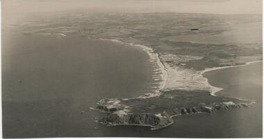
... aerial view of cape woolamai... woolamai aerial view of cape woolamai john jenner bryant west ...One of a collection of over 400 photographs in an album commenced in 1960 and presented to the Phillip Island & Westernport Historical Society by the Shire of Phillip Island.Aerial Photograph of Cape Woolamai looking north-west.local history, photography, photographs, coastline, cape woolamai, aerial view of cape woolamai, john jenner, bryant west -
 Phillip Island and District Historical Society Inc.
Photograph
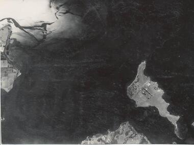
... Churchill Island Aerial view... photograph coastline islands Churchill Island Aerial view John Jenner ...One of a collection of over 400 photographs in an album commenced in 1960 and presented to the Phillip Island & Westernport Historical Society by the Shire of Phillip IslandAerial photograph of Churchill Island taken in 1939.local history, photography, churchill island, black & white photograph, coastline, islands, churchill island aerial view, john jenner, bryant west -
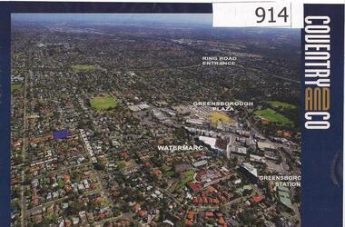 Greensborough Historical Society
Photograph, Diamond Valley Leader, Greensborough: Aerial photograph, 21/05/2013
... and Greensborough Plaza marked. An aerial view of Greensborough ...This advertisement for a property at 95 Alexandra Street Greensborough includes several aerial photographs of Greensborough with the Ring Road, Watermarc and Greensborough Plaza marked.An aerial view of Greensborough and surrounding areas in 2013.Colour advertisement including aerial photograph of Greensborough.alexandra street, greensborough plaza, watermarc -
Glenelg Shire Council Cultural Collection
Photograph - Photograph - View of port and facilities, c. 1974
Port of Portland Authority archives.Front: (no inscriptions) Back: (no inscriptions)port of portland archives -
Glenelg Shire Council Cultural Collection
Photograph - Photograph - View of port, c. 1973
Port of Portland Authority archives.Front: (no inscriptions) Back: (no inscriptions)port of portland archives -
Glenelg Shire Council Cultural Collection
Photograph - Photograph - View of Portland and foreshore, 21/03/1972
Port of Portland Authority archives.Front: (no inscriptions) Back: (no inscriptions)port of portland archives -
Glenelg Shire Council Cultural Collection
Photograph - Photograph - Aerial view of Battery Point and silos, 05/03/1971
... Photograph - Aerial view of Battery Point and silos.... Photograph Photograph - Aerial view of Battery Point and silos ...Port of Portland Authority archivesFront: (no inscriptions) Back: (no inscriptions)port of portland archives -
Glenelg Shire Council Cultural Collection
Photograph - Photograph - Aerial view of the Port of Portland from the south-west, c. 1967
... Photograph - Aerial view of the Port of Portland from the... development of silos. Photograph Photograph - Aerial view of the Port ...Port of Portland Authority archives.Front: (no inscriptions) Back: Area available for silo extension and storageport of portland archives -
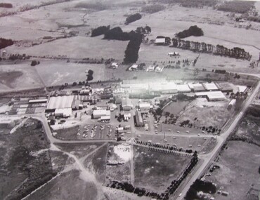
![Photograph - Digital image, Loyola Seminary 1 [aerial view] 1934, 1934_](/media/collectors/4f729f5697f83e03086015b8/items/54b9e7f82162f10918709419/item-media/54b9e8272162f109187096d4/item-fit-380x285.jpg) Greensborough Historical Society
Greensborough Historical SocietyPhotograph - Digital image, Loyola Seminary 1 [aerial view] 1934, 1934_
... Loyola Seminary 1 [aerial view] 1934... [aerial view] 1934 Photograph - Digital image ...Part of a collection of photographs of the Jesuit Seminary in Grimshaw Street Watsonia. Opened in 1934, this was a house of formation and study for the Society of Jesus. Loyola College (established 1980), now occupies the site and purchased the original building in 2002.Digital copy of black and white photograph.loyola seminary watsonia, loyola college -
![Photograph - Digital image, Loyola Seminary 7 [Aerial view with Surrounding Area] 1934, 1934_](/media/collectors/4f729f5697f83e03086015b8/items/54b9eba92162f1091870c075/item-media/54b9ebf22162f1091870c374/item-fit-380x285.jpg) Greensborough Historical Society
Greensborough Historical SocietyPhotograph - Digital image, Loyola Seminary 7 [Aerial view with Surrounding Area] 1934, 1934_
... Loyola Seminary 7 [Aerial view with Surrounding Area] 1934... [Aerial view with Surrounding Area] 1934 Photograph - Digital ...Part of a collection of photographs of the Jesuit Seminary in Grimshaw Street Watsonia. Opened in 1934, this was a house of formation and study for the Society of Jesus. Loyola College (established 1980), now occupies the site and purchased the original building in 2002.Digital copy of black and white photograph.loyola seminary watsonia, loyola college -
 Greensborough Historical Society
Aerial Photograph, Flintoff land - View from above, 1945_
... of 1945 aerial survey of Greensborough area Flintoff land - View ...Section of the 1945 Greensborough aerial survey, focusing on the land belonging to the Flintoff familyPhotocopy of section of 1945 aerial survey of Greensborough area"Flintoff land to west of Diamond Creek Rd" written in pencil on backflintoff family, aerial photograph -
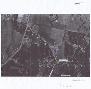 Greensborough Historical Society
Aerial Photograph, Greenhills Aerial View, 1945_
... Greenhills Aerial View... Aerial View Aerial Photograph ...Section from the 1945 aerial survey of Greensborough, including part of Diamond Creek Road, Greenhill Road, Crest Street and Albion Crescent.Photocopy of part of 1945 aerial survey. Some streets have been marked.greenhills -
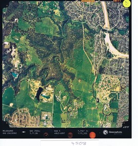 Greensborough Historical Society
Aerial photograph, Qascophoto, Greensborough, 03/11/1986
Aerial survey of Plenty Gorge Park area, including Greensborough by-pass construction and Metropolitan Ring Road reservation.An historical view of developing GreensboroughColour aerial photograph QAS 2504c run 5 3/11/86 1:15,500 by Qascophotoplenty gorge park, greensborough bypass, metropolitan ring road -
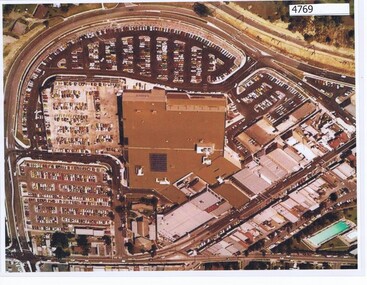 Greensborough Historical Society
Aerial Photograph, Greensborough Plaza Aerial View, 1979c
... Greensborough Plaza Aerial View... of aerial survey, laminated Greensborough Plaza Aerial View Aerial ...Early aerial photograph of Greensborough Plaza, 1970.Colour photocopy of aerial survey, laminatedgreensborough plaza -
 Glenelg Shire Council Cultural Collection
Photograph - Photograph - Aerial View of Thomas Borthwicks & Sons Meatworks, n.d
... Photograph - Aerial View of Thomas Borthwicks & Sons... Photograph - Aerial View of Thomas Borthwicks & Sons Meatworks ...On Display at History House.Framed, black and white aerial photograph of Thomas Borthwick & Sons Meatworks PortlandBack: Reg. No 58 -
Glenelg Shire Council Cultural Collection
Photograph - Photograph - Aerial view of CSR Softwoods plant, Portland, c. 1974
... Photograph - Aerial view of CSR Softwoods plant, Portland.... Photograph Photograph - Aerial view of CSR Softwoods plant, Portland ...Port of Portland CollectionUnframed, black and white aerial photograph, taken from the N.W., of C.S.R. Softwoods plant, Darts Road Portland under construction, various wool stores; skin sheds at Thomas Borthwick & Sons abattoir.Front: (no inscriptions) Back: (no inscriptions)port of portland archives, aerial photography, portland harbour -
Glenelg Shire Council Cultural Collection
Photograph - Photograph - aerial view of train track between Heywood and Rennick, 03/05/1952
... Photograph - aerial view of train track between Heywood and... vertical strip on image Photograph Photograph - aerial view ...Black and white aerial photographs (aerial survey record print) of the railway line between Heywood and Rennick (S.A. border) Taken for Victorian Railways, May 1952. Some photos have annotations later added to the front of the image in penVictorian Railways aerial survey record print of the railway line between Heywood and Rennick (S.A. border) Black and white, white vertical strip on imageFront: Annotations in red ink added at a later date Back: 'Heywood - Rennick 21579 - 19842 279m 57c ' - all black ink. Purple VR aerial survey stamp. '3 May 1952' - black stampvictorian railways, train track, transport, travel -
Glenelg Shire Council Cultural Collection
Photograph - Photograph - aerial view of railway between Heywood and Rennick, 03/05/1952
... Photograph - aerial view of railway between Heywood and... - aerial view of railway between Heywood and Rennick ...Black and white aerial photographs (aerial survey record print) of the railway line between Heywood and Rennick (S.A. border) Taken for Victorian Railways, May 1952. Some photos have annotations later added to the front of the image in penVictorian Railways aerial survey record print of the railway line between Heywood and Rennick (S.A. border) Black and white, white vertical strip on imageBack: 'Heywood - Rennick 21389 - 19660 261m 3c ' - all black ink. Purple VR aerial survey stamp. '3 May 1952' - black stampvictorian railways, train track, transport -
Glenelg Shire Council Cultural Collection
Photograph - aerial view of train track between Heywood and Rennick, 03/05/1952
... aerial view of train track between Heywood and Rennick... vertical strip on image Photograph aerial view of train track ...Black and white aerial photographs (aerial survey record print) of the railway line between Heywood and Rennick (S.A. border) Taken for Victorian Railways, May 1952. Some photos have annotations later added to the front of the image in penVictorian Railways aerial survey record print of the railway line between Heywood and Rennick (S.A. border) Black and white, white vertical strip on imageFront: Annotations in red ink added at a later date Back: 'Heywood - Rennick 21578 - 19841 279m 49c Rennick ' - all black ink. Purple VR aerial survey stamp. '3 May 1952' - black stampvictorian railways, train track, travel, transport -
Glenelg Shire Council Cultural Collection
Photograph - Photograph - aerial view of railway line between Heywood and Rennick, 03/05/1952
... Photograph - aerial view of railway line between Heywood... on image Photograph Photograph - aerial view of railway line ...Victorian Railways aerial survey record print of the railway line between Heywood and Rennick (S.A. border) Black and white, white vertical strip on imageBack: 'Heywood - Rennick 21450 - 19721 266m 72 c' - all black ink. White sticker, black print 'Marp' Purple VR aerial survey stamp. '3 May 1952' - black stampvictorian railways, aerial photography -
Glenelg Shire Council Cultural Collection
Photograph - Photograph - aerial view of the train track between Heywood and Rennick, 03/05/1952
... Photograph - aerial view of the train track between Heywood... Photograph - aerial view of the train track between Heywood ...Black and white aerial photographs (aerial survey record print) of the railway line between Heywood and Rennick (S.A. border) Taken for Victorian Railways, May 1952. Some photos have annotations later added to the front of the image in penVictorian Railways aerial survey record print of the railway line between Heywood and Rennick (S.A. border) Black and white, white vertical strip on imageFront: Annotations in red ink added at a later date Back: 'Heywood - Rennick 21577 - 19840 279m 41c ' - all black ink. White sticker, black print 'Rennick' Purple VR aerial survey stamp. '3 May 1952' - black stampvictorian railways, travel, train, transport -
Glenelg Shire Council Cultural Collection
Photograph - Photograph - aerial view of train track between Heywood and Rennick, 03/05/1952
... Photograph - aerial view of train track between Heywood and... - aerial view of train track between Heywood and Rennick ...Black and white aerial photographs (aerial survey record print) of the railway line between Heywood and Rennick (S.A. border) Taken for Victorian Railways, May 1952. Some photos have annotations later added to the front of the image in penVictorian Railways aerial survey record print of the railway line between Heywood and Rennick (S.A. border) Black and white, white vertical strip on imageBack: 'Heywood - Rennick 21453 - 19724 267m 19c ' - all black ink. Purple VR aerial survey stamp. '3 May 1952' - black stampvictorian railways, train track, transport, travel -
Glenelg Shire Council Cultural Collection
Photograph - Photograph - aerial view of Portland coast, c. 1954
... Photograph - aerial view of Portland coast... Photograph Photograph - aerial view of Portland coast ...Black and white aerial photograph of coastline around Portland. Black border, scale all sides, 5 rows of 3 't' at regular intervals. Ocean, land with lakesFront: '820 -8' - handwritten, white, lower border 'RUN 5' 'PORTLAND', printed, white, lower borderaerial photography, central portland, portland harbour, south west coastline -
Glenelg Shire Council Cultural Collection
Photograph - Photograph - aerial view of Portland coastline, c. 1954
... Photograph - aerial view of Portland coastline... Photograph Photograph - aerial view of Portland coastline ...Black and white aerial photograph of coastline around Portland. Black border, scale all sides, 5 rows of 3 't' at regular intervals. Buildings visible most areas of photoFront: '607 -107' -- handwritten, white, lower border 'RUN 5' 'PORTLAND', printed, white, lower border -
Glenelg Shire Council Cultural Collection
Photograph - Photograph - aerial view of Portland, c. 1954
... Photograph - aerial view of Portland... Photograph - aerial view of Portland ...Black and white aerial photograph of coastline around Portland. Black border, scale all sides, 5 rows of 3 't' at regular intervals. Ocean on left, land on rightFront: '607 - 54 ' - handwritten, white, border 'RUN 7' 'PORTLAND', printed, white, borderaerial photography, central portland, portland harbour, south west coastline -
Glenelg Shire Council Cultural Collection
Photograph - Photograph - aerial view of Portland coastline, c. 1954
... Photograph - aerial view of Portland coastline... - aerial view of Portland coastline ...Black and white aerial photograph of coastline around Portland. Black border, scale all sides, 5 rows of 3 't' at regular intervals. Mostly ocean, small area of land top left. See Other Information.Front: '820 - 47' - handwritten, white, border 'RUN 6' 'PORTLAND', printed, white, borderport of portland archives, aerial photography, portland harbour, south west coastline -
Glenelg Shire Council Cultural Collection
Photograph - Photograph - aerial view of Portland, c. 1954
... Photograph - aerial view of Portland..., further left than 8472 Photograph Photograph - aerial view ...Black and white aerial photograph of coastline around Portland. Black border, scale all sides, 5 rows of 3 't' at regular intervals. Half ocean, half land, separated by beach, further left than 8472Front: '607 - 91 ' - handwritten, white, border 'RUN - 6 PORTLAND', printed, white, borderaerial photography, central portland, portland harbour, south west coastline