Showing 558 items
matching kew gardens
-
 Surrey Hills Historical Society Collection
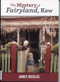
Book, The mystery of fairyland, Kew, 2017
Mrs Grace Tabulo built up a fairyland of figures depicting well-known children's stories and nursery rhymes in her garden at 57 Malmsbury Street, Kew. Many children visited and the property was especially popular on New Year's Eve. paperback, H 21 cm; 109 pagesgrace tabulo, 1877-1965 ---family, fairyland cottage, malmsbury street, kew, james nicolas, james tabulo -
 Surrey Hills Historical Society Collection
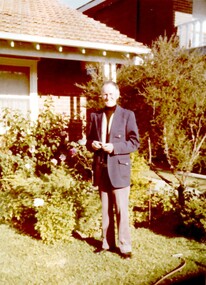
Photograph, John Reaburn outside his home, 92 Belford Road, Kew
John Colin Reaburn, also known as Jack, (1899 -1987) was an accountant by profession and an early contributor to the historical collection. He was also an active member of the Surrey Hills Progress Association. According to his grandson Peter Reaburn, this photo was taken outside John's home at 92 Belford Road, Kew where his son Robert John (1930-) spent his childhood and youth.John Reaburn was a key figure in the establishment of the Surrey Hills history collection.A coloured photograph of a man standing in a front garden. He is wearing a navy sports coat, light coloured trousers, and a black skivvy.surrey hills, history collection, surrey hills state school, accountant, 1978, clothing and dress, mr john colin reaburn, mr john reaburn, mr jack reaburn, 92 belford road kew -
 Surrey Hills Historical Society Collection
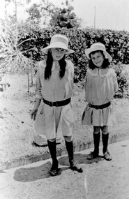
Photograph, Pat and Ruth Cornell, c1914
Patience (Pat) and Ruth Cornell, c1914 - 2 of the daughters of Frank Cornell and his wife Blanche Annie Parsons Cornell. Frank Cornell was first listed in Surrey Hills in 1906 at (6) Lorne Parade. In 1908 the listing gives his occupation as a clerk. He was born in 1869 in Richmond, Victoria and died 15 April 1917 in Surrey Hills. Blanche Annie Parsons Cornell (nee Bracher) was born in 1869 in Hokitika, New Zealand; she died on 21 January 1940. Children were: Gilbert Frank Cornell (b1894, Hawthorn; d1908, at Frankston beach, an accidental drowning) Ruth Amelia Cornell (b 1899, Kew; d 29 May 1977, Kew) Lorna Amy Cornell (b 1906, Surrey Hills; d unknown) Patience Blanche Cornell (b1907, Surrey Hills; d unknown. Frank and wife Blanche are buried in Box Hill Cemetery - CE-*-1058. Ruth Amelia married David Ellis, c1922 in Surrey Hills. David was a dentist who practised in Surrey Hills for many years; practice located in Windsor Crescent. Patience (Pat) Blanche married Norman Henry Brewer (1893–1975) in 1931 in Surrey Hills. Frank became a director of Buckleys & Nunn. The photo was taken in the garden of Felix Lloyd, Managing Director of Buckleys and Nunn. His home was in St Johns Avenue and was bought by Ormiston Girls School.A black and white photograph of two young girls dressed alike in long sleeved cotton dresses with large lace collars and a belt just below their waists. They are also wearing sun hats and knee-high dark coloured socks.(miss) ruth cornell, (miss) pat cornell, 1914, clothing and dress, uniforms, (mr) felix lloyd, buckley and nunn, st. johns avenue, surrey hills, ormiston girls school, (mr) frank cornell, (miss) patience cornell, (mrs) blanche annie parsons cornell -
 Port Fairy Historical Society Museum and Archives
Photograph
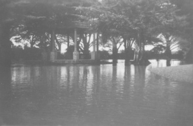
Showing the flood waters of 1946 around the Band Rotunda in the botanical gardens. Funding for the construction of the Rotunda was bequeathed in the Will of local resident Mrs Annie Williams, who was born in Daylesford in 1872 and died in Kew in 1930. Annie’s Will stipulated that the remaining value of her Estate be spent on erecting a Bandstand in the Port Fairy Botanical Gardens dedicated to the memory of her brother Hugh, a stretcher bearer in WW1 and who died in 1921 after being discharged with health issues, her husband Henry, and herself naturally. There is a plaque dedicated to Annie on the Bandstand She requested that the Bandstand be a replica of the one at Daylesford but by 1933 the value of her Estate had diminished to £76.4/8 which was insufficient to cover a similar design and the Borough Councillors felt it would be too extravagant for the Port Fairy Botanical Gardens. Local builder J.J.McLaren’s tender of £71.15/- was accepted and the octagonal concrete pillared construction was completed with the use of sustenance labour the following year. The Bandstand was opened in December, 1934 with a performance by the Port Fairy Band and local residents enjoying the entertainment and a picnic. In 1934 it was reported that there was some fuss in Council because of the whereabouts of the sum of approximately £3/- , being the amount left over from the build. After some months of debate, in which the Councillors suggested that the Engineer had used the money inappropriately, and to which he responded that the build had cost more than the quote, the matter seems to have ended there An image of the flood waters in the botanical gardens in 1946Black and white photograph of Flood water around rotunda in the gardensflood, river, botanical gardens, port fairy, moyne river, rotunda, bandstand -
 University of Melbourne, Burnley Campus Archives
Work on paper (item) - Student Work, Jude Johns, Kuti Residence Garden Design, August 2015
... at 539 High Street, Kew. Kuti Residence Garden Design Work ...It was likely made as an assignment for HORT90035, 'Landscape Construction and Graphics,' a subject at Burnley Horticultural College coordinated by Andrew Laidlaw. This is due to the fact that it was found amongst other student work submitted for this subject. assignment, landscaping, burnley -
 Port Fairy Historical Society Museum and Archives
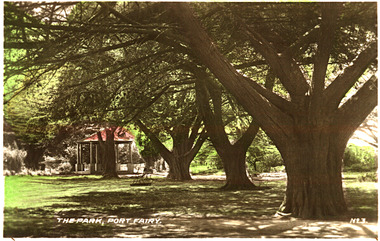
Postcard, The Park Port Fairy
Funding for the construction of the Rotunda was bequeathed in the Will of local resident Mrs Annie Williams, who was born in Daylesford in 1872 and died in Kew in 1930. Annie’s Will stipulated that the remaining value of her Estate be spent on erecting a Bandstand in the Port Fairy Botanical Gardens dedicated to the memory of her brother Hugh, a stretcher bearer in WW1 and who died in 1921 after being discharged with health issues, her husband Henry, and herself naturally. There is a plaque dedicated to Annie on the Bandstand She requested that the Bandstand be a replica of the one at Daylesford but by 1933 the value of her Estate had diminished to £76.4/8 which was insufficient to cover a similar design and the Borough Councillors felt it would be too extravagant for the Port Fairy Botanical Gardens. Local builder J.J.McLaren’s tender of £71.15/- was accepted and the octagonal concrete pillared construction was completed with the use of sustenance labour the following year. The Bandstand was opened in December, 1934 with a performance by the Port Fairy Band and local residents enjoying the entertainment and a picnic. In 1934 it was reported that there was some fuss in Council because of the whereabouts of the sum of approximately £3/- , being the amount left over from the build. After some months of debate, in which the Councillors suggested that the Engineer had used the money inappropriately, and to which he responded that the build had cost more than the quote, the matter seems to have ended there Coloured photograph (hand tinted) of the stand of cypress trees leading to the rotundaThe Park, Port Fairy - No. 3botanical, garden, cypress, tree, rotunda -
 Port Fairy Historical Society Museum and Archives
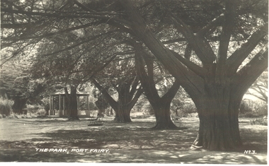
Postcard, "The Park", Port Fairy
Funding for the construction of the Rotunda was bequeathed in the Will of local resident Mrs Annie Williams, who was born in Daylesford in 1872 and died in Kew in 1930. Annie’s Will stipulated that the remaining value of her Estate be spent on erecting a Bandstand in the Port Fairy Botanical Gardens dedicated to the memory of her brother Hugh, a stretcher bearer in WW1 and who died in 1921 after being discharged with health issues, her husband Henry, and herself naturally. There is a plaque dedicated to Annie on the Bandstand She requested that the Bandstand be a replica of the one at Daylesford but by 1933 the value of her Estate had diminished to £76.4/8 which was insufficient to cover a similar design and the Borough Councillors felt it would be too extravagant for the Port Fairy Botanical Gardens. Local builder J.J.McLaren’s tender of £71.15/- was accepted and the octagonal concrete pillared construction was completed with the use of sustenance labour the following year. The Bandstand was opened in December, 1934 with a performance by the Port Fairy Band and local residents enjoying the entertainment and a picnic. In 1934 it was reported that there was some fuss in Council because of the whereabouts of the sum of approximately £3/- , being the amount left over from the build. After some months of debate, in which the Councillors suggested that the Engineer had used the money inappropriately, and to which he responded that the build had cost more than the quote, the matter seems to have ended there Black and white photograph of the stand of cypress trees with the rotunda in the backgroundThe Park Port Fairy - No 3botanical, garden, trees, rotunda, path -
 Port Fairy Historical Society Museum and Archives
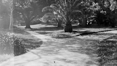
Photograph
Funding for the construction of the Rotunda was bequeathed in the Will of local resident Mrs Annie Williams, who was born in Daylesford in 1872 and died in Kew in 1930. Annie’s Will stipulated that the remaining value of her Estate be spent on erecting a Bandstand in the Port Fairy Botanical Gardens dedicated to the memory of her brother Hugh, a stretcher bearer in WW1 and who died in 1921 after being discharged with health issues, her husband Henry, and herself naturally. There is a plaque dedicated to Annie on the Bandstand She requested that the Bandstand be a replica of the one at Daylesford but by 1933 the value of her Estate had diminished to £76.4/8 which was insufficient to cover a similar design and the Borough Councillors felt it would be too extravagant for the Port Fairy Botanical Gardens. Local builder J.J.McLaren’s tender of £71.15/- was accepted and the octagonal concrete pillared construction was completed with the use of sustenance labour the following year. The Bandstand was opened in December, 1934 with a performance by the Port Fairy Band and local residents enjoying the entertainment and a picnic. In 1934 it was reported that there was some fuss in Council because of the whereabouts of the sum of approximately £3/- , being the amount left over from the build. After some months of debate, in which the Councillors suggested that the Engineer had used the money inappropriately, and to which he responded that the build had cost more than the quote, the matter seems to have ended there Black and white photograph of gardens with dividing paths and palm treebotanical, rotunda, gardens, trees, bandstand -
 Hawthorn Historical Society
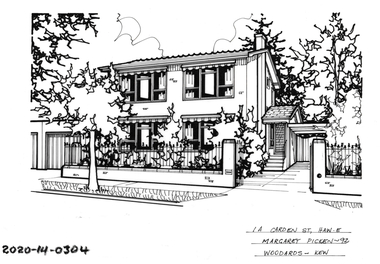
Drawing - Property Illustration, 1A Garden Street, Hawthorn East
'After training as a Cartographic Draftsman within the mining industry, I worked as a property illustrator for real estate firms in the eastern suburbs of Melbourne for 23 years from 1983. I initially photographed houses with a Polaroid camera and made a 'thumbnail' sketch while there. The photos were used to scale off a sketch in pencil and then that sketch was overlaid with drafting film and the 'pen and ink' completed. The pens I used were the Rotring ‘Rapidigraph’ drafting pens. The ink was also made by Rotring (German).The film was ‘Rapidraw’, polyester drafting film, double matte. It takes a very fine line and doesn’t bleed. As well as house sketches, there were often floor plans and site plans ordered. Aerial sketches were ordered when the property needed an overall view.' (Margaret Picken, 2020)This property illustration is one of a series created by Margaret Picken for a range of real estate agents in Melbourne between c. 1983 and c. 2006. Each work is signed and dated by the artist.Gift of Margaret Picken, 2020Pen and ink property illustration on drafting film of 1A Garden Street, Hawthorn East by Margaret Picken.1A Garden St, Haw E, Margaret Picken '92. Woodards - Kew. artist - margaret picken 1950- -
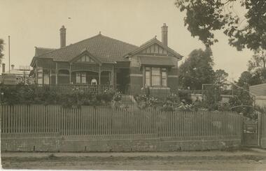 Bendigo Historical Society Inc.
Postcard - ROY AND DORIS KELLY COLLECTION: VERCLAU, 1900-1920
Postcard, B&W image of a tiled roof, brick house behind a picket fence and front lawn and flower garden. A woman stands on the front verandah and a man stands to the right of the steps up to the house. Front gate from a footpath at lower right. On the back handwritten in ink ' 1916-1917 Season's Greetings from "Verclau" Also an oval shaped stamp inside reads 'A Aberline 138 Glenferrie Rd Glenferrie' 'Verclau' is the name of the house in Stevenson St, Kew, Melbourne. According to a press death notice a family called GUY was living there in 1917.postcard, photograph, postcard, verclau, house, stevenson st, kew -
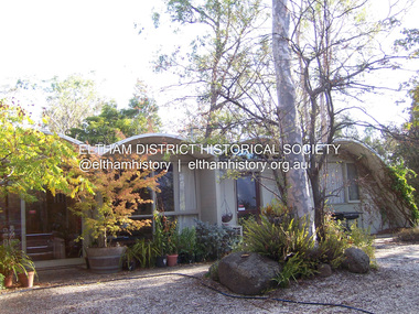
 Eltham District Historical Society Inc
Photograph - Digital Photograph, Marguerite Marshall, Former home of Professor William MacMahon Ball, York Street, Eltham, 24 May 2007
Situated at the eastern end of York Street, Eltham, 'Shinrone', the former home of Professor William (Mac) MacMahon Ball was one of the first in the Shire of Eltham to incorporate mud-brick. Professor MacMahon Ball, a political scientist, writer, broadcaster and diplomat and family moved to York Street, Eltham in 1945 into a timber cottage built around the 1890s and in poor repair. Mac asked Alistair Knox to renovate the home and he expanded the living area and added verandahs. In 1948 Montsalvat artist and sculptor Sonia Skipper supervised the building of most of the mud-brick studio. Neighbour Gordon Ford made the mud-bricks. Mac also asked John Harcourt, who had worked with him as a journalist in shortwave broadcasting, to build a pise (rammed earth) and stone addition to the largely timber house. Harcourt built two bedrooms - including an attic bedroom - a balcony with a shower and toilet, a nd a fireplace and chimney of local stone. Published: Nillumbik Now and Then / Marguerite Marshall 2008; photographs Alan King with Marguerite Marshall.; p141 At the eastern tip of York Street, Eltham, stands Shinrone, the former home of one of Australia’s intellectual leaders. Professor William Macmahon Ball, was one of the first to bring Asia as a foreign policy issue to the Australian public.1 He was a political scientist, writer, broadcaster and diplomat. The house was one of the first in Eltham Shire to incorporate mud-brick,2 because of the acute shortage of building materials after World War Two. Its novice builders later become leaders in Eltham’s built and garden design. Mac (as he was usually called), who was the son of a Church of England minister, was born in Casterton, Victoria in 1901 and died in 1986. In 1945 he helped establish the United Nations, as political consultant to the Australian Delegation at the San Francisco Conference.3 Then in 1946 Mac was appointed British Commonwealth Representative on the Allied Council for Japan, which is recorded in detail in his diary.4 In 1948 Mac led an Australian Government Goodwill Mission to South East Asia. However, Mac was perhaps most successful as an academic and public speaker.5 He was a commentator on the Australian Broadcasting Commission, from the early 1930s to the early 1960s. He was also Controller of the Short-Wave Broadcasting Unit during World War Two, which later became Radio Australia. From 1923 he taught at The University of Melbourne, then became foundation Professor of Political Science in 1949 and was Chair until his retirement in 1968.6 In 1942, as the government expected a Japanese invasion, Mac’s wife Katrine and their only child Jenny, moved from Kew to Eltham as temporary evacuees. However Mac and Katrine lived in Eltham for almost the rest of their lives. After staying with friends, they rented a house in Reynolds Road, where, as it was wartime, they needed to keep horses for transport and a cow and poultry for milk and eggs. In 1945 the family moved to the house at York Street, which was then a timber cottage, built around the 1890s and in poor repair. The underground well, cellar and part of the garden are all that remain of what stood on the original 18 acre (7.3ha) allotment. Thanks largely to Katrine’s hard work, the house was gradually renovated and extended. The long rambling house was partially built by several young neighbours, who were inspired by the cheap mud-brick and stone building style of Montsalvat, the Eltham artists’ colony. Mac asked Alistair Knox to renovate Shinrone, named after an Irish village near Katrine’s family home. Knox later popularised the mud-brick style of house construction, for which Eltham became known. He expanded the living area and added verandas. In 1948 Montsalvat artist and sculptor Sonia Skipper supervised the building of most of the mud-brick studio. Another neighbour, Gordon Ford, who was to have a major influence on the Australian garden style, made the mud-bricks. Mac also asked John Harcourt, who had worked with him as a journalist in short-wave broadcasting, to build a pisé (rammed earth) and stone addition to the largely timber house. Harcourt built two bedrooms – including an attic bedroom – a balcony with a shower and toilet, and a fireplace and chimney of local sandstone. With pioneering work naturally came mistakes, including one particularly dramatic incident when Harcourt was building walls with unsupported sections. Jenny Ellis, Mac’s daughter, remembers being awakened from sleep by a thundering shudder. The wall of her room had fallen down – fortunately away from her! In 1950 artist Peter Glass – another neighbour and later landscape designer – built Katrine a mud-brick pottery. As a result, the house features at one end Harcourt’s characteristic steep gable roof, while at the other the flatter construction characteristic of Knox. Mac referred to the home as the Eltham ‘experimental building site’.7 Surprisingly, the combination works, perhaps partly because it has the warm inviting feel of timber, mud-brick and stone.This collection of almost 130 photos about places and people within the Shire of Nillumbik, an urban and rural municipality in Melbourne's north, contributes to an understanding of the history of the Shire. Published in 2008 immediately prior to the Black Saturday bushfires of February 7, 2009, it documents sites that were impacted, and in some cases destroyed by the fires. It includes photographs taken especially for the publication, creating a unique time capsule representing the Shire in the early 21st century. It remains the most recent comprehenesive publication devoted to the Shire's history connecting local residents to the past. nillumbik now and then (marshall-king) collection, eltham, alistair knox, gordon ford, john harcourt, mudbrick construction, pise construction, professor macmahon ball, shinrone, sonia skipper, york street -
 Eltham District Historical Society Inc
Photograph - Digital Photograph, Marguerite Marshall, Rice House, 69 Ryans Road, Eltham, 27 March 2007
Built in 1953, the Rice House was leading Melbourne architect Kevin Borland's first commssion and was one of two houses of its kind. The design of the shell-like structure was inspired by the Arch of Ctesiphon, built in the second century south of Baghdad. Cement with a waterproofing agent was applied in layers to a form of regularly spaced timber arches covered in hessian. This ctesiphon system was developed in the United Kingdom by engineer J.H. de Waller in 1947. Commissioned in 1951 by Harrie and Lorna Rice, after Harrie, then an art student, met Borland at The Age Small Homes Service. Borland suggested they buy land in Eltham because at that time it was the only council in Melbourne that would grant a permit for such an innovative house. Covered under Victorian Heritage. Published: Nillumbik Now and Then / Marguerite Marshall 2008; photographs Alan King with Marguerite Marshall.; p157 Inspired by an ancient arch in Iraq, a house stands on top of a hill in a private position, off Ryans Road, Eltham. One of only two houses of its kind, it was leading Melbourne architect Kevin Borland’s first commissioned house, which he built in 1953. The shell-like structure, partially screened by giant trees and cacti, was inspired by the Arch of Ctesiphon south of Baghdad, built in the second century.1 Cement with a waterproofing agent was applied in layers to a form of regularly spaced timber arches tightly covered by hessian. This ctesiphon system was developed in the United Kingdom by engineer J H de Waller in 1947. This house was the first of three such structures built in Victoria, of which only one other remains, although substantially altered.2 It is the Wood House and supermarket, at the corner of Cleveland Road and High Street Road, Ashwood, designed by Robin Boyd in 1952. The Rice House demonstrates Kevin Borland’s innovative and experimental work. It is an outstanding example of the post-war period of experimentation in domestic architecture in Melbourne – by Robin Boyd, Kevin Borland and others – for The Age Small Homes Service from 1947 to 1953. This was partly an expression of late-Modernism and also necessitated by the post-war shortage of building materials. In Eltham, the post-war shortage of building materials largely resulted in mud-brick houses. Examples of Borland’s public work include contributions to the Olympic Swimming Pool in Melbourne and the Preshil Junior School in Kew. After more than 50 years of living in the house, Harrie and Lorna Rice still love it. Facing north-east with large windows overlooking the garden and two courtyards, it is well lit and benefits from a through breeze. The couple commissioned the extraordinary house after Harrie, then an art student, met Borland in 1951 at The Age Small Homes Service. Harrie was so impressed by the recently graduated Borland’s enthusiasm, that he asked him to design them an interesting house for a low budget.3 The unusual design presented several hurdles for the young couple before they could construct it. Borland suggested that they buy land in Eltham, because at that time it had the only council in Melbourne that would allow such an innovative house. Another hurdle was to gain finance for this remarkable house. The State Savings Bank Manager refused finance on the grounds that it was ‘unliveable’ and a ‘disgrace’. Fortunately, through a family connection, the couple borrowed money from the National Bank. But they discovered years later, that the bank’s evaluation stated the two ‘concrete sheds’ were of no value!4 The house built in off-white concrete, consists of two sections. The main house has four arches supported by brick and concrete walls that create a series of inter-connected rooms. Inside, the ceiling follows the roofline. Originally this section was only ten square metres, because of building restrictions at the time. But in 1973 Borland added two rooms and a carport. The second structure of two arches was originally a garage and a studio for art teacher Harrie Rice. To accommodate the growing family, in the mid 1950s, Borland converted the second structure into two children’s bedrooms, a kitchenette, a bathroom and a living room. The two structures were originally linked by a covered way of suspended draped-concrete, but this collapsed in the 1980s. The design has several maintenance problems. Cracks developed where two halves of the shells were joined. Then the material sprayed over the cracks became brittle, causing leaks. Fortunately Harrie found another material he could use. The valleys between the arches collect water, requiring annual painting with a waterproof material to prevent leaking. Lorna framed the house with native and exotic plants, which provide privacy and as a bonus, the garden attracted the rare Eltham Copper Butterfly.This collection of almost 130 photos about places and people within the Shire of Nillumbik, an urban and rural municipality in Melbourne's north, contributes to an understanding of the history of the Shire. Published in 2008 immediately prior to the Black Saturday bushfires of February 7, 2009, it documents sites that were impacted, and in some cases destroyed by the fires. It includes photographs taken especially for the publication, creating a unique time capsule representing the Shire in the early 21st century. It remains the most recent comprehenesive publication devoted to the Shire's history connecting local residents to the past. nillumbik now and then (marshall-king) collection, eltham, rice house, ryans road -
 Melbourne Tram Museum
Album - Charles Craig - part 1 of 2, 1950s to 1970s
Photo - see pdf file for further information. Number Brief Description CC1 S178 at Elsternwick level crossing track works CC2 Building East Preston Depot 1955 CC3 Camberwell depot – post WW2 – lots of trams and a black cat CC4 W2 584 and SW6 958 northbound – Chapel St and Brighton Road CC5 W2 357 – southbound, Chapel St Brighton Road CC6 Pascoe Vale Road, Raceday working – note the signal CC7 The Preston Workshops - The Argus, post WW2, 223, 647 et al CC8 923 or is it 922 being built at Preston – The Argus photo - CC8A 832 being positioned onto trucks at Preston after an overhaul – Argus Photo – see also CC306 CC9 Footscray depot` CC10 W5 797 in St Kilda Road during track works – 1950s CC11 W2 457 at Kew Post Office CC12 Wellington Parade – W2 432, 492 and 337 – special event CC13 Swan St line up of trams – football? Or other special event – Sinclair’s bus on the right side. CC14 W2 630 being washed at a depot – The Argus photo CC15 Royal Park line at Flemington Road – W2 355 and W5 786 CC16 Nicholson St track construction from a tram cab CC17 T181 on tour at Gordon St CC18 T181 on Maribyrnong Bridge CC19 Ditto at River St just off bridge CC20 As for CC18 CC21 At Raleigh Rd CC22 T181 at Footscray depot CC23 Track construction, Nicholson, just north of Gertrude CC24 Commissioning overhead Bourke St tram 988 CC25 Queens Parade – 997 and 994 CC26 Swapping trolley wheel to skid – commissioning CC27 Track construction in Gertrude St CC28 985 in Queens Parade running special CC29 997 in Queens Parade CC30 1033 at North Fitzroy – AETA Special CC31 Bourke St at Elizabeth St – has passengers on board CC32 W6 985, 996 Queens Parade, Mk 3 bus 333 CC33 As above CC34 Showing construction at Nicholson & Gertrude – Bourke St CC35 W2 223 on Burnley temporary bridge – VR track expansion CC36 W5 823 – ditto CC37 Tram on old bridge prior to removal CC38 W2 433 on temporary bridge with new bridge beams and old track CC39 Looking down showing temporary single track – Swan St CC40 Tait train passing under tram bridge CC41 SW6 on single line – off loading CC42 W2 547 at City Road Junction CC43 City Road Jtn – 1969 – 596 and 771 CC44 City Road Jtn – 1969 – 596 and 771 (same as CC45 438 in Flinders St CC46 355 somewhere CC47 552 somewhere CC47A 364 at Preston Workshops? CC48 W2 334 on Traverser – Preston Workshops CC49 Wellington pade – large line up of trams, c1950 925, and 611 CC50 W2 493 Franklin st – advertising for Savings Certificates CC51 Possibly 551 with advertising for fund raising for Blind institute CC52 249 at Hawthorn – Riversdale Junction – with a Tally Ho and Village Fair Aux. board CC53 MMTB Postcard of 511 CC54 Wattle Park terminus with Single line warning sign CC55 Wattle Park Duplication CC56 36 at Domain Junction – 833 CC57 36 at Domain Junction CC58 36 at Domain Junction with 810 and 833 CC59 36 in Swanston by Flinders St Station CC60 36 in Spencer St at A’Beckett CC61 36 crossing Collins St CC62 36 crossing Collins St CC63 36 northbound in St Kilda Road with Shrine in background CC64 36 northbound in Swanston St at Flinders St CC65 Postcard – Ballarat 36 in Domain Road CC66 Postcard - Stampshow – Hawthorn Horse tram CC67 Postcard - Stampshow – Peace cable tram CC68 Postcard - 1041 and cable car set 1 at Preston CC69 Postcard - Colins & Elizabeth – greetings from old Melbourne CC70 Postcard - Cable car set at Preston CC71 Postcard - Twentyman’s cable cars CC72 Postcard - Nu-color-vue – horse tram 256 CC73 Cable car set – Market & Flinders CC74 Cable trams at Twentymans’ in their shed CC75 Cable tram track at Bourke & Spencer prior to removal CC76 Cable tram bogie at Preston Workshops – used as a dolly CC77 Cable trams at Twentymans’ CC78 Postcard - Valentines – Bourke looking west from Swanston CC79 Postcard - Rose 3938 – Bourke at Swanston – the Leviathan building CC80 Postcard - Valentines – Elizabeth St looking south from Collins – No. 19 CC81 Postcard - Rose P4765 – Bourke St Melbourne CC82 Postcard - Rose 4090 – cable tram passing Parliament house CC83 Postcard - Valentines – GPO Elizabeth St CC84 Interior of cable trailer with clothing on a set CC85 Elizabeth St looking north CC86 Cigarette card - Collins St No. 41- WD HO Wills CC87 Postcard - Rialto building with cable set CC88 Postcard - Valentines - Swanston at Flinders looking north CC89 CC90 Q 150 Hanna St – dated on rear CC91 176 turning – photo ex Alan Jungworth CC92 161 on Princes Bridge – minimum fare 4d sign and Inspector CC93 459 at Point Ormond CC94 158 at Gordon St – side on view CC95 X 217 in Swanston St CC96 X 217 in Swanston St with an East Brighton destination CC97 T177 CC98 T177 Peel St – no destination roll – being transferred? CC99 X1 462 in Glenhuntly Road to Point Ormond CC100 X1 462 in Glenhuntly Road to Elsternwick Rly Station CC101 X1 462 in Glenhuntly Road to Point Ormond CC102 Q 150 Hanna St CC103 190 at Camberwell Depot CC104 T182 at Footscray CC105 X1 466 and W2 at Footscray CC106 190 at Camberwell Depot CC107 X1 467 Barkly St Footscray CC108 X2 679 turning into William St from La Trobe St CC109 X2 677 Glenhuntly Road with Point Ormond Destination CC110 Postcard T180 CC111 Postcard format – X1 467 on a truck – see also CC178 CC112 Postcard format – X1 467 at Wantirna South CC113 Q200 and SW6 896 at Thornbury – has labels on rear CC114 T177, Ballarat Road – has labels on rear CC115 T178 at Point Ormond CC116 Postcard X1 465 and 466 CC117 Postcard – X2 676 CC118 Postcard – TMSV X2 217 CC119 810 on temporary bridging – 24-12-67 CC120 W2 575 – Queens Parade junction in, still temporary bridging, substation under construction CC121 Forming Queens Parade Junction base slab CC122 W2 596 prior to tramway works – all tracks still in position CC123 It’s a mass of reinforcing – bridging being formed CC124 Looking north with substation being built CC125 Looking east with some rather tight curves, Wellington St still in use CC126 SW6 958 ex Wellington St with all tracks and signal box and buildings. CC127 Victoria Pde at Gisborne looking east – at least 4 cars CC128 SW6 893? With dash canopy lights and SW6 862 and a man with a newspaper CC129 SW6 894 on the S curves, with tram in Wellington St CC130 Similar photo CC131 W2 564 turning into Wellington St – the concrete tracks are not that old CC132 W2 552 running out of Wellington St CC133 W5 732 from Fitzroy St into St Kilda Road with next iteration in position – very wonky CC134 W5 764 turning into Fitzroy St CC135 SW6 947 turning from Wellington St CC136 W2 586 running out of High St CC137 W2 500 turning into Wellington St CC138 W2 543 in Wellington St inbound CC139 L103 with St Kilda Junction destination, and a tower truck on right CC140 Workmen – new track in Queensway in use CC141 Ditto CC142 L103 in Queensway, and another car in bound CC143 Looking east along Wellington St which has been taken out of use. Also a MMTB Roller CC144 W5 824 and a W2 and all types of wobbly temporary track CC145 W2 354 to High St CC146 Sw6 947 on the S bends CC147 W2 500 looking north – tram on the S bends CC148 SW6 896 leaving the S bend CC149 W2 357 and a MMTB City bus with trees/gardens on the side CC150 W5 817 Elliot Ave – see also CC302 CC151 W2 552 – note the large trolley bridge CC152 W2 550 at depot or workshops CC153 1B truck CC154 SW2 432 CC155 W2 155 at Glenhuntly CC156 SW6 937 on AETA tour? CC157 X2 677 on Footscray service – Ballarat Rd? CC158 W2 641 – High St Kew? CC159 SW6 847 – Power St Hawthorn CC160 Simpson St – big line up CC161 W2 546 truck No. 1? CC162 W2s at Glenhuntly depot CC163 No. 15 truck under 899 CC164 206 and other junk at Preston Workshops CC165 W in Swanston St Melbourne – Rose series card CC166 Y1 613 Batman Ave?? or William St at Collins CC167 Tram plans CC168 X 217 Swanston St – see also 95 and 96 CC169 217 in Swanston St – same as 95 CC169A 192 in St Kilda Road at Princes bridge CC170 192 in St Kilda Road at Princes bridge CC171 Bendigo 3 arriving Malvern depot – being unloaded CC172 Ditto CC173 T180 at a depot CC174 X1 463 wheel set CC175 C30 – dog car side view – close up CC176 C30 dog car CC177 206 and 30 at Preston Workshops CC178 X1 467 on a truck – see CC111 also CC179 42 CC180 42 at a depot, no destination box CC181 W2 556 1A type truck CC182 Flinders St Station – Rose Series CC183 W7 1035 Spring – Nicholson St CC184 W7 1022 MMTB Post Card CC185 Adelaide 178 – has on rear – R. Lilburn 4/82 CC186 Adelaide 175 – has on rear – R. Lilburn 4/82 CC187 Y1 610 on AETA tour CC188 Y1 610 on AETA tour with large group – Point Ormond CC189 AETA display – has GH55-32 in pencil on rear CC190 AETA display – has GH55-29 in pencil on rear CC191 Y1 610 on AETA tour with large group – Point Ormond CC192 VR 53 at Footscray CC193 VR cars 40 and 34 at Elwood wash dock CC194 W7 1024 as the 1970 Christmas tram CC195 Geelong – loading a set of 22E trucks CC196 Geelong 10 and 23 running an AETA special CC197 Geelong – AETA special CC198 Geelong 7 at Junction CC199 Geelong 10, in the city CC200 Geelong 33 with Belmont destination CC201 Geelong 15 Eastern Park destination 29-3-1948 CC202 Geelong 23 at Railway Station – 29-3-1948 CC203 Geelong 23 at Railway Station – 29-3-1948 CC204 Geelong – loading a bogie tram CC205 Geelong – loading a bogie tram CC206 Geelong 40 – loaded on truck CC207 Geelong 40 – on jacks CC208 Geelong 40 on jacks – 19 behind CC209 Geelong 38 with two workers on either side CC210 – 214 Australian Historic Tramways stamp folder and set CC215 Bendigo 17 at depot – has dup JBS on rear CC216 Bendigo 20, 29 bogie and straight sill car at Charing Cross CC217 Bendigo one man bogie Pall Mall CC218 Bendigo – Bogie 23, other cars and welding truck at depot CC219 Bendigo 7 with Quarry Hill destination CC220 Bendigo 21 with Lake Weerona destination CC221 ESCo 18 Ballarat CC222 Ballarat bogie 22 on AETA special CC223 Ditto CC224 Ballarat 34 at Stones Corner – R Lilburn CC225 Ballarat 15 in Bridge St – R Lilburn CC226 Ballarat 40 at Gardens – R Lilburn CC227 Ballarat 37 running out of depot – R Lilburn CC228 Postcard – Valentines – Sturt St with loaded horse tram trailer CC229 AETA Geelong tram tour ticket – 29-3-1948 CC230 Postcard – Geelong – Valentine 2114 – T&G building CC231 Postcard – PMTT ! – High St Malvern CC232 Postcard – Empire – Glenferrie Road, Malvern at Wattletree Rd CC233 Postcard Y469, MMTB CC234 Postcard Z2 Spring St CC235 Postcard – Z1 MMTB CC236 Postcard – Stamp Show W1 431 CC237 Postcard – Stamp show B2005 CC238 Postcard – Stamp show W6 982 CC239 Postcard – Valentines 1264 – Johnstone Park with tram in distance CC240 Postcard – Rose 10711 – Swanston and Lonsdale – Hospital and W232 CC241 Postcard – Rose 4827 – Fitzroy St St Kilda W2 362 and 548 CC242 Postcard – Valentines – 939 – St Kilda War Memorial, W and a R? CC243 Postcard – Valentines – 572 – St Kilda War Memorial, W 413 and 140? CC244 Postcard – Valentines – 938 – Uper and Lower Esplanade – L 104 CC245 Postcard – St Kilda Rd at Princes Bridge Y1 and W CC246 Postcard – Biscay BG82 – W5 814 - CC247 Postcard – Biscay 796112 – Bourke St looking west CC248 Postcard – Biscay 796109 – Bourke St looking east CC249 Postcard – Biscay 2AUS58 – Z5 Bourke St CC250 Postcard – Biscay BG 249 – Swanston St CC251 Postcard – National View – St Kilda Rd – shrine and Prince Henrys W2 405 CC252 Postcard – Nu color vue – 11 ML 156 – St Kilda Rd CC253 Postcard – Nu color vue – 11 ML 153 – Swanston St CC254 Postcard – Nu Color vue – Collins St 442 CC255 Postcard – Pitt card – Adelaide – H 364 at Victoria St CC256 Postcard – SPER L/P 154 CC257 Postcard – BTMS – 550 CC258 Postcard – SPER – Brisbane 295 CC259 Adelaide 131 at Burnside – has R Lilburn on card, c1911 CC260 Adelaide 194 CC261 Adelaide 235, with two crew, The News photo CC262 Rockhampton, outside post office – has source of photo details CC263 Sydney – 2086 and 2062 arriving Circular Quay CC264 Sydney – P class – Pitt St? CC265 Sydney – 1610 at Circular Quay CC266 Brisbane 99 and 468 CC267 Sydney with bridge behind CC268 Steam tram Paramatta Park – 103 CC269 Sydney – Museum Station =- Elizabeth St CC270 Sydney – weed burner 137S at a loop Demonstrates the work of Charles Craig in photography and collection of prints.Assembled album in a black presentation folder of 270 photographs from the Charles Craig Collection - 86 sleeves - part 1 of 2. All photographs have been scanned and placed on the Museum's G drive. A list of all photographs with details where possible has been compiled. Victorian Provincial, Launceston, Hobart and Sydney tram photos have been transferred to other Museums, image files retained.melbourne, tramways, tramcars, trams, charles craig, st kilda junction, trackworks -
University of Melbourne, Burnley Campus Archives
Map, Yarra 2500, 1983-1988
Photocopies of set of maps, Melbourne and Metropolitan Board of Works. Scale 1:2500. (1) Municipalities of Brunswick 213 Coburg 217 Northcote 218 Broadmeadows 237 Whittlesea 239 and Preston225. Yarra 2500/07.16-07.22. (2) Municipalities of Fitzroy 205 Collingwood 206 Kew 215 Northcote 218 Brunswick 213 Coburg 217 Preston 225. Yarra 2500/08.12-08.17. (3) Municipalities of Collingwood 206 Kew 215 Northcote 218 Yarra 2500/09.12-09.13. (4) Municipalities of Eltham 238 Yarra 2500/18.21. Plus some extra copies. Used when planning Native Garden Woodland Section. 25 sheetscoburg, northcote, broadmeadows, melbourne and metropolitan board of works, collingwood, eltham, kew, whittlesea, brunswick, preston -
 Kew Historical Society Inc
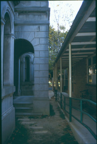
Slide - Hospital wing and Villa Alba entrance porch, 2001
Built for William and Anna-Maria Greenlaw in the early 1880s, and with interiors decorated by the Paterson Bros, Villa Alba remained in private ownership until 1949. From 1950, the house was owned by a number of institutions. By 1984, the Villa Alba Preservation Society had been formed, and three years later, the Mount Royal Hospital granted a 25-year lease to Kew Council. In 2004, the title to Villa Alba was passed by the Victorian Government to The Villa Alba Museum Incorporated. Digital copy of a olour 35mm slide, framed in a plastic mount, of the entrance to Villa Alba, 44 Walmer Street, Kew, 3101, in 2001. The transparency shows the grey rendered entry, viewed from the east, looking west. At this stage a wing of the hospital abutted the portico. The hospital wing was subsequently demolished and a Victorian era garden reinstated based on an original plan."Villa Alba 2001 / Les Littlechild photo"villa alba museum, mount royal hospital, historic houses -- kew (vic.), victorian architecture -- melbourne (vic.) -
 Kew Historical Society Inc
Slide - Hospital wing and Villa Alba entrance porch, 1987–2001
Built for William and Anna-Maria Greenlaw in the early 1880s, and with interiors decorated by the Paterson Bros, Villa Alba remained in private ownership until 1949. From 1950, the house was owned by a number of institutions. By 1984, the Villa Alba Preservation Society had been formed, and three years later, the Mount Royal Hospital granted a 25-year lease to Kew Council. In 2004, the title to Villa Alba was passed by the Victorian Government to The Villa Alba Museum Incorporated. Digital copy of a oolour 35mm slide, framed in a plastic mount, of the entrance to Villa Alba, 44 Walmer Street, Kew, 3101. The transparency shows the grey rendered tower, viewed from the east, looking west. At this stage a wing of the hospital abutted the south facade. The hospital wing was subsequently demolished and a Victorian era garden reinstated based on an original plan."Villa Alba exterior"villa alba museum, historic houses -- kew (vic.), victorian architecture -- melbourne (vic.), mount royal hospital -
 Kew Historical Society Inc
Slide - Hospital wing and Villa Alba's south-facing facade, 1987–2001
Built for William and Anna-Maria Greenlaw in the early 1880s, and with interiors decorated by the Paterson Bros, Villa Alba remained in private ownership until 1949. From 1950, the house was owned by a number of institutions. By 1984, the Villa Alba Preservation Society had been formed, and three years later, the Mount Royal Hospital granted a 25-year lease to Kew Council. In 2004, the title to Villa Alba was passed by the Victorian Government to The Villa Alba Museum Incorporated. Digital copy of a olour 35mm slide, framed in a plastic mount, of the entrance to Villa Alba, 44 Walmer Street, Kew, 3101. The transparency shows the grey rendered portico, viewed from the west, looking east. At this stage a wing of the hospital abutted the portico. The hospital wing was subsequently demolished and a Victorian era garden reinstated based on an original plan."Villa Alba ext"villa alba museum, historic houses -- kew (vic.), victorian architecture -- melbourne (vic.), mount royal hospital -
 Kew Historical Society Inc
Slide - Hospital wing and Villa Alba's south-facing facade, 1987–2001
Built for William and Anna-Maria Greenlaw in the early 1880s, and with interiors decorated by the Paterson Bros, Villa Alba remained in private ownership until 1949. From 1950, the house was owned by a number of institutions. By 1984, the Villa Alba Preservation Society had been formed, and three years later, the Mount Royal Hospital granted a 25-year lease to Kew Council. In 2004, the title to Villa Alba was passed by the Victorian Government to The Villa Alba Museum Incorporated. Digital copy of a olour 35mm slide, framed in a plastic mount, of the entrance to Villa Alba, 44 Walmer Street, Kew, 3101. The transparency shows the grey rendered portico, viewed from the east, looking west. At this stage a wing of the hospital abutted the portico. The hospital wing was subsequently demolished and a Victorian era garden reinstated based on an original plan."Villa Alba ext"villa alba museum, historic houses -- kew (vic.), victorian architecture -- melbourne (vic.), mount royal hospital -
 Kew Historical Society Inc
Slide - Rear of Villa Alba with adjacent hospital wing, 1987–2001
Built for William and Anna-Maria Greenlaw in the early 1880s, and with interiors decorated by the Paterson Bros, Villa Alba remained in private ownership until 1949. From 1950, the house was owned by a number of institutions. By 1984, the Villa Alba Preservation Society had been formed, and three years later, the Mount Royal Hospital granted a 25-year lease to Kew Council. In 2004, the title to Villa Alba was passed by the Victorian Government to The Villa Alba Museum Incorporated. Digital copy of a olour 35mm slide, framed in a plastic mount, of the portico of Villa Alba, 44 Walmer Street, Kew, 3101. The transparency shows the grey rendered rear of the building, viewed from the east, looking west. A two storey wing of the Mount Royal Hospital, facing Nolan Avenue is at the right. The slide shows a set of wire gates separating the east garden of Villa Alba from the main house."Villa Alba"villa alba museum, mount royal hospital, historic houses -- kew (vic.), victorian architecture -- melbourne (vic.) -
 Kew Historical Society Inc
Slide - Hospital wing and Villa Alba portico, 1987–2001
Built for William and Anna-Maria Greenlaw in the early 1880s, and with interiors decorated by the Paterson Bros, Villa Alba remained in private ownership until 1949. From 1950, the house was owned by a number of institutions. By 1984, the Villa Alba Preservation Society had been formed, and three years later, the Mount Royal Hospital granted a 25-year lease to Kew Council. In 2004, the title to Villa Alba was passed by the Victorian Government to The Villa Alba Museum Incorporated. Digital copy of a oolour 35mm slide, framed in a plastic mount, of the entrance to Villa Alba, 44 Walmer Street, Kew, 3101. The transparency shows the grey rendered portico, viewed from the west, looking east. At this stage a wing of the hospital abutted the portico. The hospital wing was subsequently demolished and a Victorian era garden reinstated based on an original plan."Villa Alba ext"villa alba museum, historic houses -- kew (vic.), victorian architecture -- melbourne (vic.), mount royal hospital -
 Bendigo Historical Society Inc.
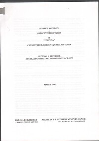
Document - Pompeii Fountain & Adjacent Structures at "Fortuna"
Fortuna Villa was initially commenced as a modest single storey home in 1861 next to the 180 Mine by Theodore Ballerstedt, who sold the mine and house to George Lansell in 1869. Lansell already owned the adjacent Fortuna Mine, and through deeper mining techniques greatly expanded the mine's operation, his personal wealth, and the house and grounds. Lansell was soon known as the 'Quartz King', Australia's first gold mining millionaire and credited as the driving force behind much of Bendigo's prosperity. He continuously added to and expanded the villa, decorating it extravagantly with the finest of artworks and materials, into a sprawling mansion with extensive landscaped grounds, to create a house and grounds of a size and grandeur with few rivals in Australia. After his death in 1907, his second wife Edith carried on with improvements, creating a house and grounds developed over 50 years. The attached mine also contributes to its significance, being one of the richest mines in Bendigo, and at one stage probably the deepest gold mine in the world at 3176 feet. The 1875 crushing works are attached directly to the mansion, and the mine's tailings and settling ponds (turned into ornamental lakes) represent a direct link between George Lansell's wealth and its source. Fortuna was compulsorily acquired by the Commonwealth in 1942 as the Cartographic Headquarters of the Australian Survey Corps during World War II, and many ancillary structures were added while preserving the main house and ornamental grounds. Victorian Heritage Database Report https://vhd.heritagecouncil.vic.gov.au/places/68334/download-reportConservation report for the Pompeii Fountain & Adjacent Structures at "Fortuna" Chum Street, Golden Square, Victoria. Prepared for Fortuna Historical Committee. March 1996.Halina Eckersley, Architect & Conservation Planner, Kewpompeii fountain, greenhouse, fortuna lake, gardens -
 Wangaratta RSL Sub Branch
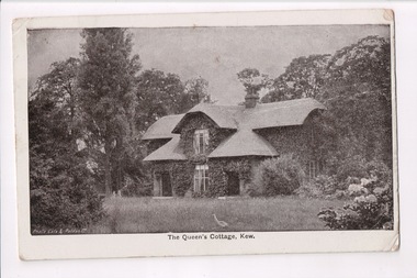
Postcard, 1917
From the album of WWI soldier William West (1268) of the 29 Infantry Battalion, 5th Pioneers Battalion. This collection of postcards, photographs and clippings were sent between William and his family and loved ones during the years he was on active service. See also 207 and 220. Postcard with a black and white photograph of a cottage in a garden settingFront "the Queen's cottage, Kew"album, photo album, newspaper clippings, postcard, wwi, photograph, kew, the queen's cottage -
 Ballarat Heritage Services
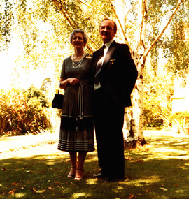
Photograph - digital copy, Jack and Kathllen Gervasoni Mayor and Mayoress of Kew 1979-80 at Chellowdene, 1979
Chellowdene was an architect designed triple fronted 1950s brick dwelling with an Edna Walling garden at 37 Wills Street, Kew. It was demolished by the subsequent owner.Copy of a colour photograph showing City of Kew Mayor John H. Gervasoni and Mayoress Kathleen Gervasoni in the front of their Kew property 'Chellowdene', 37 Wills Street, Kew. mayor, mayoral, portrait, kew, gervasoni, john, jack, k, mayoress, chellowdene, wills, kew mayors, wills street kew -
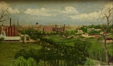 Kew Historical Society Inc
Painting - Panoramic View of Kew and Abbotsford from the garden of Rockingham, V Maloney, 1952
The extensive formal landscaped gardens of Rockingham had been created in the 1860s, and by the 1950s remained bordered to the south by the Barkers Road cutting, and to the north by Blytheswood, the neighbouring Syme family property, By 1940, the Syme family were no longer the occupiers of Rockingham. John Herbert Syme had died in October 1939, and by August the following year, his wife had made the house and garden available, rent free to the Red Cross as a convalescent home for Australian soldiers injured in the Second World War. At the time, the house was described as containing twenty rooms, including a ballroom and a billiards room, with a garden of eight acres overlooking the Yarra. The task of renovating the house to conform to its new function as a convalescent home took a year, finally opening in August 1941. Community support for Rockingham was widespread and included the decision by the National Gallery of Victoria to loan pictures from its collection to decorate the walls. Calls were made for women around Victoria to donate fruit and vegetables from their gardens, which the railways agreed to freight for free. Other local support included the work by a team of boys to establish a three-acre vegetable garden within the formal terraced gardens. From the beginning, occupational therapy formed a key component of the rehabilitation of psychologically injured soldiers. This is confirmed by contemporary newspaper accounts of weaving, ironwork, leatherwork, basketry and gardening by patients. Numerous photographs, held by the Australian War Memorial (AWM) and the State Library of Victoria (SLV), record the importance of these rehabilitation activities. The painting of the view across the river to Abbotsford may have been painted in one of these occupational therapy sessions. For many decades it hung in the occupational therapy room. It must have been on view following the sale of Rockingham by the Syme family to the Red Cross in 1955, and subsequently, until the house was demolished and its grounds finally subdivided in 1977.View of Abbotsford from the garden of Rockingham (1952) was created by V Maloney. The vantage point of the artist was the garden of Rockingham, one of two mansions overlooking the Yarra owned by the Syme family. The artwork depicts a number of sites - especially factories - that have since been demolished.Signed by the artist, lower right "V Maloney"rockingham red cross convalescent home, hospitals - kew (vic), rosemary lade, art therapy -
 Melbourne Tram Museum
Ephemera - Timetable, Melbourne & Metropolitan Tramways Board (MMTB), Set of 14 MMTB Bus timetables, Jul. 1969
All July 1969 - no route numbers shown. .1 - Box Hill - Heidelberg - Templestowe .2 - East Kew - Box Hill - Doncaster .3 - Deer Park - Sunshine Park - Sunshine - Footscray - City .4 - Fishermen's Bend - City .5 - Williamstown Rd - Footscray Railway Stn - Ballarat Rd .6 - Garden City - City .7 - La Trobe University - Northland - West Heidelberg - City .8 - Box Hill - North Blackburn .9 - Bulleen - North Kew - City .10 - Clifton Hill - Elsternwick .11 - Box Hill - East Doncaster - Mitcham - Ringwood .12 - Deer Park - Sunshine Park - Sunshine - Footscray - City - Saturdays and Sundays - printed on pink paper. 13 - Warrandyte - Donvale Post Office - City 14 - Warrandyte - Park Orchards, Ringwood.Yields information about MMTB Bus services July 1969Set of 14 MMTB Bus timetables, folded sheets, providing timetables for specific routes, day of week giving information on tram times at specific time points, route map, sections and fares and organisation address - 616 Little Collins St. Melbourne.trams, tramways, timetables, tickets, bus services, fares, mmtb -
 Melbourne Tram Museum
Ephemera - Timetable/s, Public Transport Victoria (PTV), Set of 25 digital timetables, 2018
Set of 25 digital timetables generally applicable from 20-05-2018 following the introduction of more frequent services on many routes. Image files are htd2860iRx - x being the route number. Route 1 - East Coburg - South Melbourne Beach Route 3 and 3A - Melbourne University - East Malvern - and via St Kilda Beach Route 5 - Melbourne University - Malvern Route 6 - Melbourne University - Glen Iris Route 8 - Moreland - Toorak Route 11 - West Preston - Victoria Harbour Docklands Route 12 - Victoria Gardens - St Kilda Route 16 - Melbourne University - Kew Via St Kilda Route 19 - North Coburg - Flinders St Route 30 - St Vincent's Plaza - Etihad Stadium Docklands Route 35 - City Circle Route 48 - North Balwyn - Victoria Harbour Docklands Route 55 - West Coburg - Domain Interchange Route 57 - West Maribyrnong - Flinders St Route 59 - Airport West - Flinders St Route 64 - East Brighton - Melbourne University Route 67 - Carnegie - Melbourne University Route 70 - Wattle Park - Waterfront City Docklands Route 72 - Camberwell - Melbourne University Route 75 - Vermont South - Etihad Stadium Docklands Route 78 - North Richmond - Balaclava via Prahran Route 82 - Footscray - Moonee Ponds Route 86 - Bundoora RMIT - Waterfront City Docklands Route 96 - East Brunswick - St Kilda Beach Route 109 - Box Hill - Port Melbournetrams, tramways, timetables, yarra trams, route 1, route 3, route 5, route 6, route 8, route 11, route 12, route 16, route 19, route 30, route 35, route 48, route 55, route 57, route 59, route 64, route 67, route 70, route 72, route 75, route 78, route 82, route 86, route 96, route 109 -
 Melbourne Tram Museum
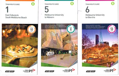
Ephemera - Tram Route Guides, Public Transport Victoria (PTV), "Tram Route Guide", Feb. 2016
Set of 18 Tram Route Guides, published during 2016. Each comprises a vertical DL folded sheet, full colour for the nominated routes, with Yarra Trams and PTV logos, listing the stops, interchanges with bus and other tram services, ticketing zones, estimated frequencies with adverts for Night tram services, TramTracker and Myki tickets. .1 - Route 1 - East Coburg to South Melbourne Beach .2 - Route 5 - Melbourne University to Malvern .3 - Route 6 - Melbourne University to Glen Iris .4 - Route 8 - Moreland to Toorak .5 -Route 57 - West Maribyrnong to Flinders St Station (2 copies) .6 - Route 70 - Wattle Park to Waterfront City Docklands .7 - Route 72 - Melbourne University to Camberwell .8 - Route 75 - Vermont South to Etihad Stadium / Bourke St Docklands .9 - Route 82 - Footscray to Moonee Ponds .10 - Route 19 - North Coburg to Flinders St Station .11 - Route 55 - West Coburg to Domain Interchange (two copies held) .12 - Route 59 - Airport West to Flinders St Station .13 - Route 30 - St Vincent's Plaza to Ethida Stadium Docklands .14 - Route 12 - Victoria Gardens to St Kilda / Fitzroy St .15 - Route 64 - Melbourne University to East Brighton .16 - Route 78 - North Richmond to Balaclava (via Prahran) .17 - Route 86 - Bundoora (RMIT) to Waterfront City Docklands .18 - Route 96 - East Brunswick to St Kilda Beach .19 - Route 11 - West Preston to Victoria Harbour Docklands ,20 - Route 16 - Melbourne University to Kew via St Kilda .21 - Route 48 - North Balwyn to Victoria Harbour Docklands .22 - Route 67 - Melbourne University to Carnegie .23 - Route 109 - Box Hill to Port Melbourne See Reg Item 2396 for 2012, 2939 for 2015 and 2940 for 2014 versions Items .13 to .18 added 2/9/18Item 11 has the "5" changed to "8" in Texta - see history of object.trams, tramways, timetables, maps, route 1, route 5, route 6, route 8, route 11, route 16, route 132, route 19, route 30, route 48, route 55, route 57, route 59, route 64, route 67, route 70, route 72, route 75, route 78, route 82, route 86, route 96, route 109, east coburg, west coburg, airport west, north coburg, south melbourne, malvern, glen iris, moreland, toorak, west maribyrnong, wattle park, docklands, camberwell, vermont south, footscray, moonee ponds, st vincent's plaza, victoria gardens, east brighton, north richmond, balaclava, bundoora, east brunswick, west preston, kew, north balwyn, carnegie, box hill -
 Melbourne Tram Museum
Ephemera - Timetable/s, Public Transport Victoria (PTV), Set of 25 digital timetables - Yarra Trams, 2016
Set of 25 digital timetables generally applicable 2016 to 13/4/2017. Similar timetables ran during 13/4/2017 and 1/5/2017 over the Easter Holiday period up to when Route 58 (from route 8 and route 55) introduced and route 6 modified - see Reg item 2212 for details. List major stops only. All downloaded from the PTV website 9-4-17 as pdf files. Image files are htd2211iRx - x being the route number. Route 1 - East Coburg - South Melbourne Beach Route 3 and 3A - Melbourne University - East Malvern - and via St Kilda Beach Route 5 - Melbourne University - Malvern Route 6 - Melbourne University - Glen Iris Route 8 - Moreland - Toorak Route 11 - West Preston - Victoria Harbour Docklands Route 12 - Victoria Gardens - St Kilda Route 16 - Melbourne University - Kew Via St Kilda Route 19 - North Coburg - Flinders St Route 30 - St Vincent's Plaza - Etihad Stadium Docklands Route 35 - City Circle Route 48 - North Balwyn - Victoria Harbour Docklands Route 55 - West Coburg - Domain Interchange Route 57 - West Maribyrnong - Flinders St Route 59 - Airport West - Flinders St Route 64 - East Brighton - Melbourne University Route 67 - Carnegie - Melbourne University Route 70 - Wattle Park - Waterfront City Docklands Route 72 - Camberwell - Melbourne University Route 75 - Vermont South - Etihad Stadium Docklands Route 78 - North Richmond - Balaclava via Prahran Route 82 - Footscray - Moonee Ponds Route 86 - Bundoora RMIT - Waterfront City Docklands Route 96 - East Brunswick - St Kilda Beach Route 109 - Box Hill - Port Melbournetrams, tramways, timetables, yarra trams, route 1, route 3, route 5, route 6, route 8, route 11, route 12, route 16, route 19, route 30, route 35, route 48, route 55, route 57, route 59, route 64, route 67, route 70, route 72, route 75, route 78, route 82, route 86, route 96, route 109 -
 Melbourne Tram Museum
Ephemera - Timetable/s, Public Transport Victoria (PTV), Set of 24 digital timetables - Yarra trams, 2016
Set of 24 digital timetables generally applicable 1/4/2017 to end 2017 Introduced when Route 58 (from route 8 and route 55) amalgamated and route 6 modified - see Reg item 2212 for details. All downloaded from the PTV website 9-4-17 as pdf files, except for routes 6 and 58 which had not been published as of that date. Timetables list major stops. Routes 6 and 58 files added 6-6-2017. Image files are htd2213iRx - x being the route number. Route 1 - East Coburg - South Melbourne Beach Route 3 and 3A - Melbourne University - East Malvern - and via St Kilda Beach Route 5 - Melbourne University - Malvern Route 6 - Moreland - Glen Iris Route 11 - West Preston - Victoria Harbour Docklands Route 12 - Victoria Gardens - St Kilda Route 16 - Melbourne University - Kew Via St Kilda Route 19 - North Coburg - Flinders St Route 30 - St Vincent's Plaza - Etihad Stadium Docklands Route 35 - City Circle Route 48 - North Balwyn - Victoria Harbour Docklands Route 57 - West Maribyrnong - Flinders St Route 58 - Toorak - West Coburg via William St. Route 59 - Airport West - Flinders St Route 64 - East Brighton - Melbourne University Route 67 - Carnegie - Melbourne University Route 70 - Wattle Park - Waterfront City Docklands Route 72 - Camberwell - Melbourne University Route 75 - Vermont South - Etihad Stadium Docklands Route 78 - North Richmond - Balaclava via Prahran Route 82 - Footscray - Moonee Ponds Route 86 - Bundoora RMIT - Waterfront City Docklands Route 96 - East Brunswick - St Kilda Beach Route 109 - Box Hill - Port Melbournetrams, tramways, timetables, yarra trams, route 1, route 3, route 5, route 6, route 11, route 12, route 16, route 19, route 30, route 35, route 48, route 57, route 58, route 59, route 64, route 67, route 70, route 72, route 75, route 78, route 82, route 86, route 96, route 109 -
 Melbourne Tram Museum
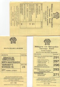
Ephemera - Timetable/s, Melbourne & Metropolitan Tramways Board (MMTB), "MMTB Bus Timetables", 1981 - 1984
Timetables for specific routes, day of week giving information on tram times at specific time points, route map, sections and fares and organisation address - 616 Little Collins St. Melbourne. All printed on yellow paper. .1 - Timetable for Box Hill via Shoppingtown and Templestowe, Doncaster bus services, dated July 1981 - routes 291, 297, 296, 293 and 271. .2 - Services via Templestowe, North Balwyn and Kew, Warrandyte and Newmans Rd - routes 276, 278 and 279 - July 1982 .3 - Services via East Doncaster, North Balwyn, Kew, Warrandyte, City, Shoppingtown - routes 277, 280, 281 and 268 - dated Jan. 1983 .4 - ditto as above, including Park Orchards and Donvale - routes 265, 262, 261, 260, 266 and 264 - dated Feb. 1983 .5 - North Altona - City Route 232 - April 1984 - issued by Metropolitan Transit with their logo. 6 - Garden City, Port Melbourne - City - Sept 1982 - routes 201, 202 7 - Sunshine - Footscray - City - Routes 230 and 231 - Jan. 1982 8 - North Altona - City - MMTB logo, route 232 - Nov. 1982 9 - East Kew, Box Hill, Doncaster - Express bus - Box Hill to City - routes 284, 270, 300 - April 1982 10 - Ringwood - Warrandyte, Park Orchards, Mitcham - routes 313, 31, 315 and 316 - Jan. 1983Yields information about MMTB Bus services early 1980s and 1 The Met badged item.Set of 9 MMTB and 1 MTA Bus timetables, folded sheets, 8 sections.trams, tramways, mmtb, timetables, melbourne, fares, east kew, box hill, doncaster, north altona, route 232, route 201, route 202, route 220, route 231, route 284, route 270, route 300, route 313, route 314, route 315, route 316