Showing 11589 items matching " map"
-
 Greensborough Historical Society
Map, Municipality of Heidelberg Plan No. 481, 23/9/1949
Central area of Greensborough, South boundary Grimshaw Street, showing river and buildings in green and gradients in red. Adjoins Map No. 480 to West.Black & white map with features in red and green. Scale: 160 feet to 1 inch.greensborough, grimshaw street greensborough -
 Federation University Historical Collection
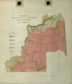
Plan - Map, Mines Department, Parish of Narmbool and part of Cargerie, County of Grant, 1892, 06/1992
This map shows the position of the homestead on the Narmbool Pre-emptive Right, volcanic craters, stock reserve, quarry and geological eras,Geological map showing Narmbool and part of Cargerie in the County of Grant in five colours, predominantly pink.narmbool, cargerie, narmbool pre-emptive right, williamson's creek, leigh river, green hill, collyer's hill, volcano, crater, krause, ferdinand krause -
 Bendigo Military Museum
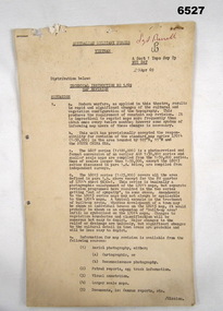
Administrative record - Australian Military Forces Vietnam - Technical Instruction 1/69 - Map Revision, Major EP Constantine, Nui Dat, Vietnam, 29 Apr 1969
This is a Technical Instruction to formalise the Map Revision process at the Royal Australian Survey Corps, A Sect 1 Topo Svy Tp, NUI Dat, Vietnam in 1969. This Instruction details the methods to be used to manage the updating of the current theatre mapping to ensure map users are advised of the latest map changes, either additions or deletions from when the original map was produced.11 x foolscap pages of typed text and diagrams, stapled and two hole punched. Paper dis-colouredHand written top right hand corner in red "Sgt Birrell"royal australian survey corps, rasvy, fortuna, army survey regiment, army svy regt, asr, australian force vietnam -
 Albert Park-South Melbourne Rowing Club
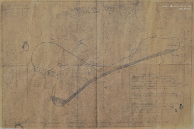
Map, Albert Park Lake, Post-1957
A dyeline-type map of Albert Park Lake and buildings.ALBERT PARK LAKE / 1" = 320 / TIME RESTRICTIONS / SPEEDBOATS HAVE FULL USE OF THE HATCHED AREA AT THE FOLLOWING TIMES / SUNDAYS - 12 NOON - 5.30PM RACE DAYS. / 2.30PM - 3.30PM ALL OTHER DAYS / TUESDAYS & THURSDAYS - 2.00PM - 4.00PM / SATURDAYS - 8.00AM - 11.00AM / ROWING - CONFINED TO WESTERN BANK / UNRESTRICTED TIME EXCEPT IN SPEEDBOAT AREA / YACHTS, HIRE BOATS - UNRESTRICTED TIME & AREA EXCEPT IN SPEEDBOAT AREA. / (CARE TO BE TAKEN IN ROWING AREA / IF POSSIBLE KEEP CLEAR) / RESTRICTED TIMES & AREAS FOR LAKE USEalbert park lake, rowing, apsm rowing club, map, albert park rowing club, south melbourne rowing club -
 Dandenong/Cranbourne RSL Sub Branch
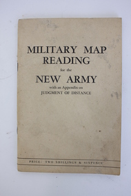
Booklet, Robertson & Mullens Ltd et al, Miltary Map Reading for the New Army with an Appendix on Judgment of Distance, 1941
Beige booklet bound with two staples. White pages within with black illustrations and type. 64 pages.Front: "MILITARY MAP / READING / for the / NEW ARMY / with an Appendix on / JUDGMENT OF DISTANCE / PRICE: TWO SHILLINGS & SIXPENCE"military map reading, orientation, navigation -
 Ballarat Heritage Services
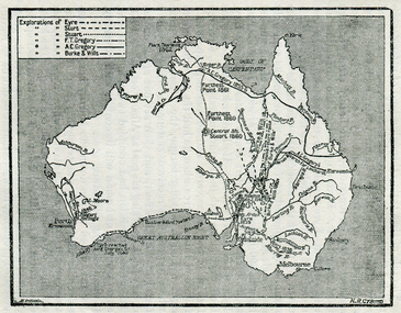
Map, Exploration of Eyre, Sturt, Stuart, Gregory, Burke, and Wills
Copy of a map from 'A Short History of Australia' by Ernest Scott.map, explorers, exploration, burke and wills, sturt, stuart, gregory, melbourne, perth, sydney, mitchell river, a.c. gregory, darling river, lachlan river, mt stuart, murray river -
 National Vietnam Veterans Museum (NVVM)
Booklet, British Army, Manual of Map Reading: Air Photo Reading and Field Sketching, Part 1: Map Reading, 1955 (Copy 1), 1955
A red coloured cover with black information. There are signs of possible water damage down the right hand side of the booklet. At the top figth hand reads WO Code No. 8868. Down the spine of the book reads Manual of Map Reading: Air Photo Reading and Field Sketching : 1map reading, air photo reading, manual -
 National Vietnam Veterans Museum (NVVM)
Booklet, British Army, Manual of Map Reading: Air Photo Reading and Field Sketching, Part 1: Map Reading, 1955 (Copy 2), 1955
A red coloured cover with black information. There are signs of possible water damage down the right hand side of the booklet. At the top figth hand reads WO Code No. 8868. Down the spine of the book reads Manual of Map Reading: Air Photo Reading and Field Sketching : 1map reading, air photo reading, manual -
 Warrnambool and District Historical Society Inc.
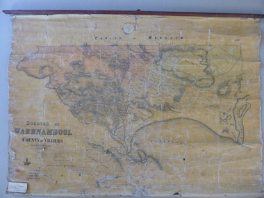
Mao, Borough of Warrnambool, County of Villiers, 1873
This is an early map of the Borough of Warrnambool (1872/3) showing the central town area of Warrnambool and the surrounding district. Reserves, public buildings and some businesses are marked. The map was photolithographed by John Noone, a Melbourne artist and photographer who claimed in 1858 to have the oldest-existing photographic studio in Melbourne. Photolithography was a process first developed in Melbourne. For several years Noone was the official photographer for the Victorian Crown Lands Office and for the Victorian Public Library and Museum. The map has the stamp of the seller of the map – Charles Hider, the well-known stationer and bookseller in Timor Street, Warrnambool. The owner of the map, Henry George Marfell, (1883-1962) was the son of John and Mary Ann Marfell. The Marfells were well-known in Warrnambool as grain merchants and managers of the Warrnambool Co-Operative Milling Company. It is surmised from the writing on the Marfell label that this map was at some stage given by Henry Marfell to the old Warrnambool MuseumThis map of early Warrnambool is of considerable significance, firstly because its original state and early date (1873) make it of antiquarian and historical interest. Also the connection with the names, Charles Hider and Henry Marfell and the old Museum gives it added provenance and interest.This is a wax paper map mounted on cloth. At the top it is attached by nails to a piece of wood and at the top it has a cloth ring for hanging the map. The map is in black shadings on a yellow background. The map is badly creased and coming away from the cloth at the edges and at other various points. There is some red or pink marking or staining on the township area of the map (originally the sold lands on this map were coloured in brown and the reserves, buildings, etc in pink). On the left hand corner there is a piece of paper glued on with some handwriting in ink (Marfell). There is also the stamp of the seller of the map – Charles Hider, stationer and bookseller, of Timor Street Warrnambool‘Early Map of W’bool, H.G. Marfell’ history of warrnambool, charles hider, henry marfell -
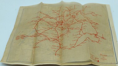 Ringwood RSL Sub-Branch
Booklet, Paris map
Map of Paris and info booklet for Englishmen and Americans and toilet guide -
 Eltham District Historical Society Inc
Slide - Photograph, Old map of Diamond Creek catchment, c.Sep. 1989
Part of a slide show presentation "Bridges & Waterways of the Shire" by Russell Yeoman to the 13 September 1989 Society meeting. The presentation included slides of historic photos from the Shire of Eltham Pioneers collections as well as several recent views.35mm colour positive transparency (1 of 33) Mount - Agfa CS System grey 8 dotsProcess Date Sep 1989diamond creek catchment, map -
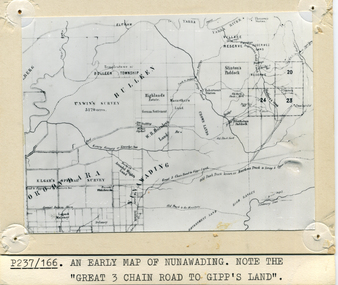 Whitehorse Historical Society Inc.
Photograph - B/W Photograph, Map of Nunawading
Black and white photo of early sub-division of Nunawading.|NOTE:- Great 3 Chain Road to Gipp's Land.nunawading, map -
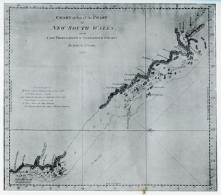 Ballarat Heritage Services
Photograph - Map, Portion of Captain James Cook's Chart of New South Wales, 1770, 1770
Copy of a map from 'A Short HIstory of Australia' by Ernest Scott.map, explorers, exploration, voyages, captain james cook, new south wales coast -
 Victorian Aboriginal Corporation for Languages
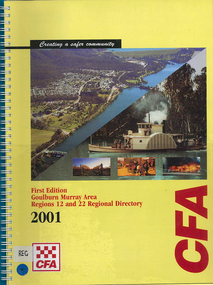
Map, Country Fire Authority, Goulburn Murray Area regions 12 and 22 regional directory, 2001
mapsgoulburn river, fire protection districts, northern victoria -
 Victorian Aboriginal Corporation for Languages
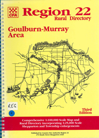
Map, Country Fire Authority, Region 22 rural directory Goulburn-Murray area, 1997
mapsgoulburn region, fire protection, emergency services, victorian maps, directories -
 Victorian Aboriginal Corporation for Languages
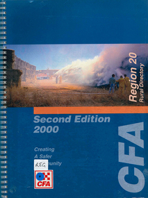
Map, Country Fire Authority, Region 20 rural directory, 2000
mapskerang, regional maps, atlas, fire protection -
 Victorian Aboriginal Corporation for Languages
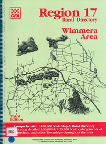
Map, Country Fire Authority, Region 17 rural directory : Wimmera area, 1997
mapshorsham, wimmera, west wimmera, hindmarsh, yarramback, grampians, fire protection, emergency services, victorian regional maps -
 Victorian Aboriginal Corporation for Languages
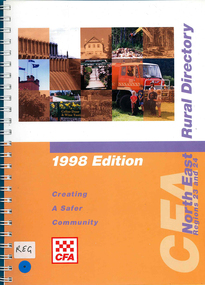
Map, Country Fire Authority, Regions 23 and 24 north east rural directory, 1998
mapswodonga, albury, wangaratta, benalla, maps, victoria, fire protection -
 Victorian Aboriginal Corporation for Languages
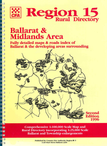
Map, Country Fire Authority, Region 15 rural directory : Ballarat &? Midlands Area : fully detailed maps &? roads index of Ballarat &? the developing areas surrounding, 1996
mapsballarat, fire protection, victorian regional maps, emergency services -
 Victorian Aboriginal Corporation for Languages
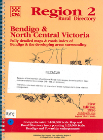
Map, Country Fire Authority, Region 2 rural directory : Bendigo &? North Central Victoria: fully detailed maps &? roads index of Bendigo &? the developing areas surrounding, 1996
mapsbendigo, loddon, fire protection, victorian regional maps, directories -
 Victorian Aboriginal Corporation for Languages
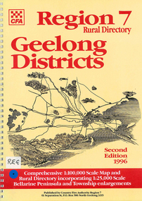
Map, Country Fire Authority, Region 7 rural directory Geelong districts, 1996
Shows roads, railway, power lines, buildings and emergency locations. Lists property owners.mapsgeelong, regional victoria, fire protection -
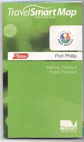 Melbourne Tram Museum
Document, Ministry of Transport, "Travel Smart Map - Port Phillip", 2010
Gives extensive details of walking cycling Public Transport in Port Phillip. Printed 2010. Yields information about Port Phillip transport and other services in 2010Map - pocket - 28 fold - showing walking, cycling and public transport in the City of Port Phillip, using a Melway Map base along with public transport information, Metcard, cycling and walking groups.tramways, melbourne, tram services, bus services, railways, port phillip, cyclists -
 Ringwood and District Historical Society
Pamphlets, Vic Roads, Pamphlets about Ringwood Bypass development, and one map. 1991-96, 1991-1996
Pamphlets about Ringwood Bypass development. Qty 6. With one map. -
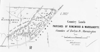 Ringwood and District Historical Society
Photograph, Early map of parishes of Ringwood and Warrandyte in Counties of Evelyn and Mornington - c.1868, 1868
Copy of an early map of parishes of Ringwood and Warrandyte, Counties if Evelyn and MorningtonWritten on backing sheet, "c1868. Vol. 5, Fol.13/1224". -
National Vietnam Veterans Museum (NVVM)
Audio - Audio, CD, Coral/Balmoral Map for NVVM
Package contains 1 Audio, CD of the map; paperwork pertaining to the battlevietnam war, 1961-1975 - battlefields - balmoral, vietnam war, 1961-1975 - battlefields - coral -
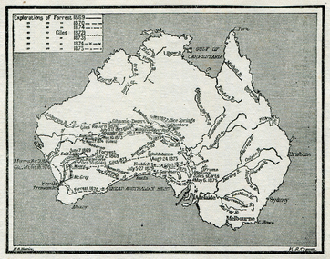 Ballarat Heritage Services
Map, Exploration of Eyre, Sturt, Stuart, Gregory, Burke, and Wills
Copy of a map from 'A Short History of Australia' by Ernest Scott.map, explorers, exploration, stuart, gregory, melbourne, perth, sydney, darling river, murray river, adelaide, albany, fitzroy river, flinders river, brisbane, great australian bight, gulf of carpentaria, mount grey, forrest -
 Lara RSL Sub Branch
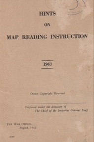
Booklet, Hints of Map Reading Instruction 1943, 00/08/43
Used to instruct the serviceman how to read and question learnt material about map reading. The map as a plan, as a reference point, a measurement of distance, a relief and direction in any situation Paper Booklet with 24 pages that have faded to a beige colour A5 in size ReservedFront page has the name of the booklet with added date 1943. Crown Copyright. Prepared under the direction of the Imperial General Staff The War Office August 1943 22307booklet, map instruction, 1943 -
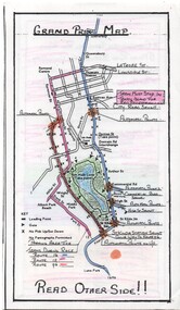 Melbourne Tram Museum
Map, Yarra Trams, "Grand Prix Map", 1996
Laminated sheet - to fit into a pocket - prepared by Greg Rodgers for Camberwell Depot drivers using Park St Kilda Grand Prix services - give details of automatic points, safety notes, details of St Kilda Road points, and what Camberwell drivers are to do. Greg Rodgers advised 5-11-2016, made for the first Grand Prix 1996.trams, tramways, camberwell depot, grand prix, map, public transport, park st st kilda -
 The 5th/6th Battalion Royal Victoria Regiment Historical Collection
Booklet - Book, Map Reading No. 13 1942, 1942
Military guide to map readingBook made of yellowed paper with black print. It is bound by two staples and has three holes punched into the left side for storage in a ring binder. There is a crease that runs from the bottom left to the top right of the cover.wark vc club, military manuals, ww2, regimental property -
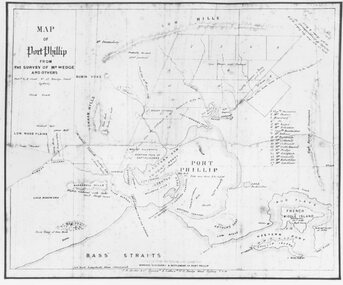 Ringwood and District Historical Society
Photograph, Map of Melbourne & Vicinity - 1853. Survey of Port Phillip. Plan in Bonwick's "Settlement of Port Phillip"
Catalogue card reads, 'Map of Melbourne & Vicinity - 1853. Survey of Port Phillip. Plan in Bonwick's "Settlement of Port Phillip"'.