Showing 1087 items matching " navigation"
-
 Lakes Entrance Historical Society
Photograph, Lakes Post Newspaper, 1999
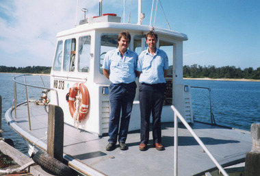
Lakes Post newspaper article re the sand transfer system, 14 April, 1999Colour photograph of two officers named, left to right, Brett Greer and Shane Clark standing on a vessel owned by Gippsland Ports, named Latrobe. Lakes Entrance Victorianavigation, waterfront, buildings -
 Lakes Entrance Historical Society
Book, Hughes, Thea Stanley, Matthew Flinders, 1985
An account of the life, explorations and achievements of Matthew Flinders. Written for students. Contains bibliography.explorers, navigation, bibliography -
 Lakes Entrance Historical Society
Photograph - The Entrance, 1950c
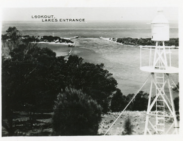
Also postcard 7 x 10.5, similar image,Black and white photograph of the entrance, taken from lookout on Jemmys Point, shows signal light adjacent to lookout, people on slope in front of signal, New Works cottages on hummocks, ocean horizon in distance. Lakes Entrance VictoriaThe Entrance from Jemmy's Pointwaterways, ocean, navigation -
 Lakes Entrance Historical Society
Photograph - Jemmys Point, 1925
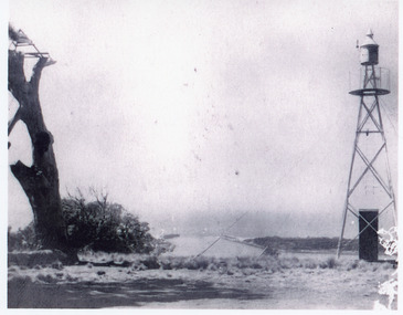
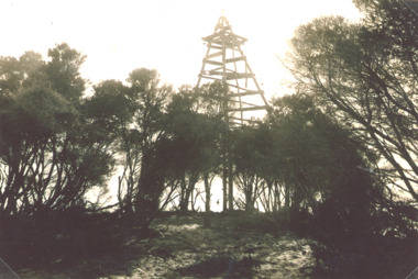
Plus 1 x black and white small format photograph 6.5 x 6.5 taken from lookout, has signal light only|Plus 3 x small format postcards 6.5 x 8.5 taken from lookout, signal light quite distinct, with inscription Lookout Lakes EntranceBlack and white photograph of the entrance, taken from Jemmys Point between the old lookout tree and the signal light. Lakes Entrance Victoria coast, navigation, waterways -
 Lakes Entrance Historical Society
Photograph - Jemmys Point Light Lakes Entrance, 1926
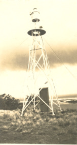
Black and white photograph of light on Jemmys Point Lakes Entrance. Plus five other photos - .2 photo of Bullock Island and the entrance, .3 Bullock Island Footbridge, .4 Rigby and Snake Islands, .5 Rigby Island Reeves Channelnavigation, waterways, gippsland lakes -
 Lakes Entrance Historical Society
Photograph - Timber Beacon Gippsland Lakes, Vacinity of Raymond Island Victoria, 1900 c
On back of original Raymond Island Tambo River in distance. This survey lookout has been washed away, seawater has killed vegetation and allowed erosionBlack and white photograph of a timber beacon on land in Gippsland Lakes in vacinity of Raymond Island Victoriaboats and boating, navigation, waterways -
 Lakes Entrance Historical Society
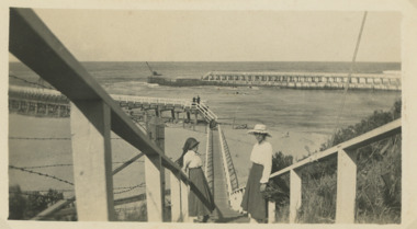
Photograph, Flagstaff to Eastern Pier, Lakes Entrance Victoria, 1920 Easter
Sepia photograph taken top of steps leading down from Flagstaff to Eastern Pier walkway two women on steps, crane on end of Western Pier Lakes Entrance Victoria. Also same photo in black and white topography, waterways, navigation -
 Lakes Entrance Historical Society
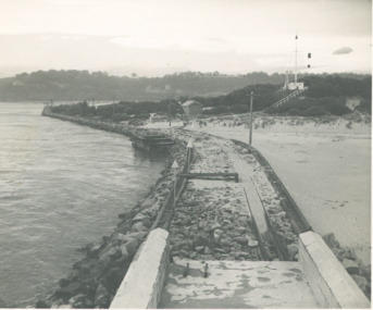
Photograph - Flagstaff above the entrance channel at Lakes Entrance Victoria c1952, L Carpenter, 1/11/1952 12:00:00 AM
Black and white photograph of the eastern pier taken from the light at the southern end looking towards the entrance to Cunninghame Arm and showing the flagstaff above the entrance channel at Lakes Entrance Victoria c1952 .. Also a black and white photograph showing both entrance piers taken from the beach near the eastern pier Lakes Entrance piers, navigation, waterways -
Lakes Entrance Historical Society
Booklet - Broadbents Motor Route Map Booklet
Booklet containing maps and information re routes, mileage, hotels, garages between Sydney and Melbourne via Princes HighwayBooklet containing maps and information 124 pagesnon-fictionBooklet containing maps and information re routes, mileage, hotels, garages between Sydney and Melbourne via Princes Highwaynavigation, accommodation, travel -
 Flagstaff Hill Maritime Museum and Village
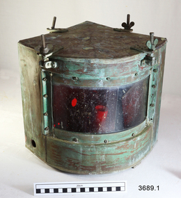
Functional object - Navigation Side Lamp, early 20th century
This pair of navigational lamps or lights was fitted to the vessel S.S. Rowitta when it was renovated to become a display passenger ferry at Flagstaff Hill Maritime Village from 1976-2015. Navigation lamps are used to indicate a vessel’s position and direction of travel to other vessels nearby. This system of coloured lamps is standardised throughout the world for all marine vessels, red is for port and green for starboard, (red is for the boats right hand side). These navigation lamps were not the original fittings for this vessel but had come from a similar vessel of the same era of the early 1900’s. The history of the lamp fittings at this time is unknown. SS ROWITTA: - The 1909 steam ferry, SS Rowitta, was installed as an exhibit at Flagstaff Hill in 1975 and was enjoyed by many visitors for 40 years. Rowitta was a timber steam ferry built in Hobart in 1909 using planks of Huon and Karri wood. She was a favourite of sightseeing passengers along Tasmania’s Tamar and Derwent rivers for 30 years. Rowitta was also known as Tarkarri and Sorrento and had worked as a coastal trading vessel between Devonport and Melbourne, and Melbourne Queenscliff and Sorrento. In 1974 Rowitta was purchased by Flagstaff Hilt to convert into a representation of the Speculant, a historic and locally significant sailing ship listed on the Victorian Heritage Database. (The Speculant was built in Scotland in 1895 and traded timber between the United Kingdom and Russia. Warrnambool’s P J McGennan & Co. then bought the vessel to trade pine timber from New Zealand to Victorian ports and cargo to Melbourne. She was the largest ship registered with Warrnambool as her home port, playing a key role in the early 1900s in the Port of Warrnambool. In 1911, on her way to Melbourne, she was wrecked near Cape Otway. None of the nine crew lost their lives.) The promised funds for converting Rowitta into the Speculant were no longer available, so she was restored back to her original configuration. She represented the importance of coastal traders to transport, trade and communication in Australia times before rail and motor vehicles. Sadly, in 2015 the time had come to demolish the Rowitta due to her excessive deterioration and the high cost of on-going repairs. She had given over 100 years of service and pleasure to those who knew her. These lamps are an historical example of navigational equipment used in the early 20th century, adhering to a navigational standard that is worldwide, and a design similar to what is still being used today. They were used on the display vessel at Flagstaff Hill Maritime Village as an aid to maritime education. The Rowitta represents the importance of coastal traders to transport, trade and communication along the coast of Victoria, between states, and in Australia before rail and motor vehicles. The vessel was an example of a ferry built in the early 20th century that served many different roles over its lifetime of over 100 years. Two side navigation ship's lamps, quarter circle shaped metal boxes with glass window and removable lid. The lid attaches to the box using four brackets, wingnuts and screws that swing down out of the way. The window of double-thickness glass is inserted on the curved side of the box and attached by screws around the frame. The inner glass panel is coloured according to the lamp’s use; port is red and starboard green. The port lamp has a round hole cut into each of the two straight sides and an electrical fitting inside. The starboard lamp also has a hole in each straight side (one with a threaded fitting). Its lid has an additional cross bar on top that has a circular space in the centre, nuts and screws fit through holes in the ends and a folding handle is attached across the centre space. The lamps were once fitted onto the vessel Rowitta. The starboard lamp has an inscription stamped into the metal. Impressed on 3689.2; “STARBOARD PATT 8025” flagstaff hill, warrnambool, flagstaff hill maritime museum, maritime museum, flagstaff hill maritime village, navigation lamp, navigation light, navigation equipment, starboard patt 8025, ship’s fitting, rowitta, tarkarri, speculant, purdon & featherstone of hobart, passenger ferry 1909, vessel, display rowitta, display passenger ferry, sorrento -
 Bendigo Military Museum
Equipment - FLYING INSTRUMENTS, AIR NAVIGATION
Flying instruments used by Flight Lieutenant Ian A. Lyons. Part of the Flight Lieutenant Ian A. 'Joe' Lyons MBE Collection. See Catalogue No. 5374P for his service record.Rectangular padded and sectioned wooden box containing seventeen brass, stainless steel and plastic air navigation instruments. The box is covered in black leatherette and hinged with small brass hinges. A silver coloured clasp secures the box closed. A metal plate is pinned to the middle of the lid.equipment, flying instruments, air navigation, flight lieutenant ian a. lyons -
 Lakes Entrance Historical Society
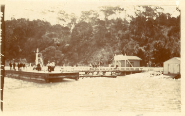
Photograph - Kalimna Jetty, 1930c
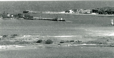
Black and white photograph of Kalimna Jetty. It shows a substantial jetty and landing, storage shed and boat shed, navigation light on end of jetty, many people on jetty, perhaps waiting for arrival of passenger steamer, in background steep cliffs bordering shoreline. Lakes Entrance Victoriawaterways, topography, jetties -
 Lakes Entrance Historical Society
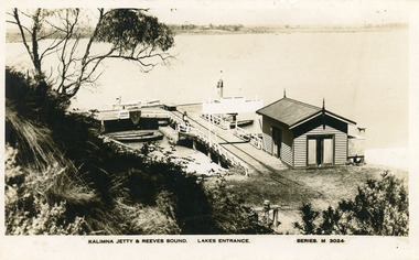
Postcard - Kalimna Jetty, Valentine Series, 1930c
Also Black and white copy print 15 x 25Black and white postcard of Kalimna Jetty. It shows a substantial timber jetty with rail line and goods trolley, storage shed with square water tank. Passenger launch and four rowing boats moored at jetty. Navigation light towards end of jetty. Lakes Entrance VictoriaKalimna Jetty and Reeves Sound Lakes Entrance Series M 3024 jetties, waterways, boats and boating -
 City of Moorabbin Historical Society (Operating the Box Cottage Museum)
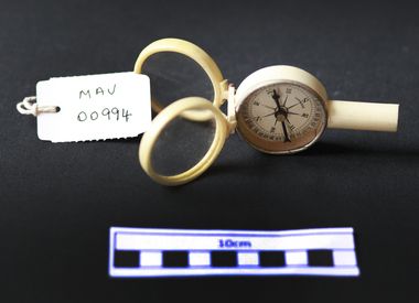
Tools, Compass, 20thC
A compass is an instrument used for navigation and orientation that shows direction relative to the geographic cardinal directions, or "points". -
Moorabbin Air Museum
Manual (Item) - Technical Manual Illustrated Parts Breakdown Electrical System Aircraft: Bandeirante T.O.Emb110 P1-4
Description: Radio communications Navigation Systems EMB 110P1 Publisher: Embraer Level of Importance: World. RAAF -
 Port Fairy Historical Society Museum and Archives
Photograph, S.S. Casino moored at Casino wharf, Port Fairy
S.S. Casino flagship of the Belfast & Koroit Steam Navigation Company, Purchased 1882. Built in Dundee, ScotlandFirst ship purchased by the Belfast & Koroit Steam Navigation Company in 1882Photographship, boat, sea, river, port fairy, s s casino, belfast & koroit steam navigation company -
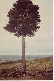 Clunes Museum
Photograph, LONE PINE
AVIATION NAVIGATIONAL AID? POINT DEPICTING THE TOP OF MOUNT BECKWITH - GOOD TALKING POINT FOR VISITORS AND LOCALSTINTED COLURED PHOTOGRAPH LONE PINE STANDING ON TOP OF MOUNT BECKWORTH.MOUNT BECKWORTH PINE TREEphotographs, lone pine, mt beckworth -
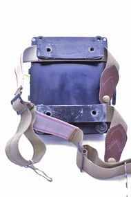 Montmorency–Eltham RSL Sub Branch
Equipment - Navigational Computer
Rectangular calculating instrument with (1) 'hinged lid' fitted with circular rotating dial for setting/reading altitude, speed, distance and temperature, (2) notebook inside lid, (3) circular dial with perspex cover, beneath which is (4) graph chart, moveable up-and-down by means of rotating knob on side of device. Curved brackets and elasticized straps on back for strapping onto pilot's leg.R.A.A.F. Ident. No. G6B/145 Serial No. WG/2233 COMPUTER NAVIGATIONAL Mk. III D. (Other inscriptions including instructions for use and scales for various measurements) "AB" hand written on strap (owner's initials?) -
Port Fairy Historical Society Museum and Archives
Photograph
Pt Fairy Wharf Fish Train 1942 .Belfast and Koroit Steam Navigation Company office on the left of the photographblack and white photograph of train shunting a wagon to the wharftransport, rail, road, gipps street, wharf, train -
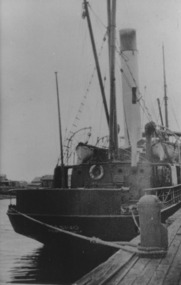
 Lakes Entrance Historical Society
Photograph - The Entrance, 1920c
Copied from photograph in possession of J WhadcoatBlack and white photograph showing stone piers at entrance to Gippsland Lakes from ocean - Bass Strait. Eastern pier on left, dune and western pier on right. Cranes and some work sheds on left. Navigation light on tip of Bullock Island on extreme right. Lakes Entrance Victoriajetties, waterways, topography, township -
 Rutherglen Historical Society
Book, Kath Bentley et al, River of Islands: Charts of the River Murray Yarrawonga Weir to Hume Dam, November 1983
Book contains information and sketch maps to aid in the navigation of the Murray River, with advice on hazards to look for as these will change over time.74 page A4 book with a drawing of a boat on the Murray River on the coverAutographed on the title page by the authors: "9-1-84 Leon Bentley | Kath Bentley"murray river, boating, river navigation, boating safety -
 Flagstaff Hill Maritime Museum and Village
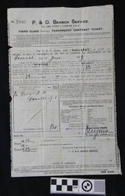
Document - Ticket, voyage, P & O Branch Service, P & O, Australia via The Cape Service, Bef.3rd June 1929
The bearer of this ticket was George Thomas Henry Phillpot, who was only 17 years old when he sailed on the S.S. Ballarat (II), built in 1921. (The first S.S. Ballarat was built in 1911 and sunk after being hit by a torpedo in 1917 while serving during WWI). George relates his trip from England to Australia, summarised as follows: He caught a bus from Bolton to Manchester, in the north west U.K., then the train from Manchester to London and the boat train to Tilbury Docks (near Gravesend). On the morning of June 7th 1929, the ship S.S. Ballarat sailed down the Thames estuary and into the English Channel. The next port of call was Southampton, UK, to take on board some technical equipment. The S.S. Ballarat then sailed through the Bay of Biscay. Instead of taking the customary route around the Cape of Good Hope, this trip, on her maiden voyage, was through the Suez Canal. She sailed through the Straits of Gibraltar, into the Mediterranean Sea and on to Malta, where George and others paid a local boat owner to take them ashore for a short time. They then sailed to Port Said, stopping to load cargo, then at night through the Suez Canal. They woke up early the next morning to watch the locals working on the banks of the canal. The excessive heat on board the ship caused much illness. As they travelled through the Red Sea, the heat and the smell of oil also caused sickness. On they went through the Arabian Sea to Colombo, the capital of Sri Lanka (which at that time was called Ceylon). A Navigation Slip, donated together with this ticket, shows the coordinates for a location 16 miles from Colombo. They again went ashore for a meal at four-pence a head and a bottle of lemonade for a penny. George and another passenger walked to the slums area and were shocked at the state of it compared to Britain’s slums. They then sailed via the Indian Ocean to Fremantle, stopping again for goods to be unloaded. While ashore, they played a game of soccer against the ship’s crew. Then on to Port Adelaide via the Great Australian Bight. Here they shopped for suitable clothing under the advice of some Australian passengers. They then arrived at Port of Melbourne on July 20th 1929, and two days later (on George’s mother’s birthday). George left for Warrnambool. He received his Citizenship Award in 1971. He conducted an electrical retail business in Liebig Street for many years. His son William became principal of the accounting business Sinclair and Wilson, on the retirement of Bill Sinclair, and was actively involved in support of many community organisations. His daughter-in-law, Glenys Phillpot, is actively involved in the Warrnambool community and local government. George was one of 3 orphans on the S.S. Ballarat. (The daughter and son-in-law of one of the other orphans also live in Warrnambool.) Herbert B.G. Larkin, whose rubber-stamped name appears on the ticket, later migrated to Australia and passed away in NSW in 1944. Of Historical Significance, this ticket is for the ship’s maiden voyage via the Suez Canal route (previously the ship travelled via the Cape of Good Hope). It is also the only existing ticket for the "S.S. Ballarat"(3rd) in our collection. Socially, it shows the fare, luggage restrictions, conditions and weekly provisions for a third-class passenger’s voyage from London to Melbourne, which has research potential. This ticket is also of significance to the Local Community, giving the background of the ancestor of a local family. It was also of Personal Significance to the bearer as he kept and preserved it in his possession for at least 46 years before donating it to our museum, together with a Navigation Slip, a map and a summary of his journey to Australia.Third Class steerage Passenger’s Contract Ticket, accompanied by the Navigation Slip, for passage on board the P & O line’s steamer, S.S. Ballarat, to Australia via the Cape Service, from Port of London to Port of Melbourne. The ticket contract is printed on both sides of a thin paper page. The documents have been completed by hand, and the pages have creases as though they have been folded. Details include the date of sailing, amount paid, and the signature of the P & O Branch Service’s representative. The contract ticket lists weekly provisions for the voyage, a disclaimer of the shipping company, a list of dangerous goods not to be carried on board, and fines. The page has straight edges, top and bottom, and perforated edges on the sides; some perforation holes are complete. A small fleur de lies is printed along the inside of each perforation, forming a decorative left and right border. Stamps and inscriptions are on the contract ticket and navigation slip, which also has a black and white photo of a steam ship.The ticket has been stamped in black, No. ‘1040’. Handwritten details are in black pen and ink. Date of departure: ‘Seventh June [192]9’ for the cost of,’33’ [poind], and the sum of ‘33’ pounds is acknowledged as received. ‘Mr George T.H. PHILLPOT’, the age is written as ‘17’, equal to the status of ‘1’ adult, the total number of persons is ‘One’. The fare is handwritten in pen £’33’ and the total £’33’. It has a purple stamp ‘HERBT. B G LARKIN’ and a crossed out stamp ‘FREDERICK WHITE, A handwritten signature ‘_Seymore’. Under the signature, the date is stamped ‘3 JUNE 1929’.warrnambool, shipwrecked coast, flagstaff hill, flagstaff hill maritime museum, maritime museum, shipwreck coast, flagstaff hill maritime village, s.s.ballarat, phillpot, 7 june 1929, george phillpot, george t.h. phillpot, third class passenger, steerage passenger, herbert b g larkin, ticket, voyage, p & o, australia via the cape, cape of good hope, suez canal, passengers’ contract ticket, navigation slip, s.s. ballarat, steamship, 1929, 3-6-1929, 7-6-1929, third-class, steerage, port of london, port of melboune, 33 pounds, george thomas henry phillpot, herbt. b g larkin, _seymore, bolton, manchester, english channel, southampton, bay of biscay, straits of gibraltar, maritia, port said, arabian sea, colombo, sri lanka, ceylon, indian ocean, fremantle, port adelaide, citizenship, 1971, herbert b.g. larkin, s.s. ballarat ii, -
 4th/19th Prince of Wales's Light Horse Regiment Unit History Room
Functional object - Sun Compass
This type of kit was used by the Regiment for vehicular cross country navigation. The crew commander would stand in front of the vehicle with a prismatic compass and guide the driver to align the vehicle on the back bearing of the required direction of travel. The discs were set for time of day and the required bearing and the driver would watch the compass and steer so that the shadow of the gnome was on the arrow. The compass would be re-set about every half hour to adjust for rotation of the Earth. In featureless country navigation was by dead reckoning by direction travelled by compass and distance travelled from the vehicle odometer. Armoured vehicles are now equipped with GPS navigation aids rendering the sun compass obsolete Type of equipment used by the Regiment on exercisesMetal construction. One fixed and one rotatable aluminium disc with a vertical steel gnome at the centre. The lower disc is marked with bearings in mils, the upper with time of day. There is a rotatable aluminium arrow under the 2 discs. A 33 mm dia spirit level is fixed to the top disc.On spirit level "GENERAL #847"daytime use only, navigation aid -
 Orbost & District Historical Society
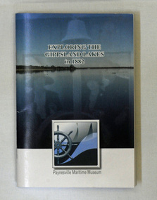
book, Exploring the Gippsland Lakes 1882, January 2010
The original book was published in Melbourne by M.L. Hutchinson, 1881. This edition was specially compiled for the Lakes Navigation Company by J. Blackwood Howie.A small book - Exploring the Gippsland Lakes 1882. this is a republication of a C 1882 book titled Tourists and Sportsman's Guide to the Gippsland Lakes and Surrounding Country. This pocket reading republishes a story from 1882 that was aimed at promoting tourism to the Gippsland Lakes. It starts with a train trip from Melbourne to Sale and then boards a steamer to experience the Gippsland Lakes. The book was published by Paynesville Maritime Museum in January 2010. It was compiled by J. Howie Blackwood.gippsland-lakes travel tourism-east-gippsland -
 Flagstaff Hill Maritime Museum and Village
Functional object - Ship's Wheel Hub, 1886-1908
The Falls of Halladale was an iron-hulled, four-masted barque, used as a bulk carrier of general cargo. She left New York in August 1908 bound for Melbourne and Sydney. In her hold was general cargo consisting of roofing tiles, barb wire, stoves, oil, and benzene as well as many other manufactured items. After three months at sea and close to her destination, a navigational error caused the Falls of Halladale to be wrecked on a reef off the Peterborough headland on the 15th of November, 1908. The captain and 29 crew members survived, but her cargo was largely lost, despite two salvage attempts in 1908-09 and 1910. The Court of Marine Inquiry in Melbourne ruled that the foundering of the ship was entirely due to Captain David Wood Thomson's navigational error, not too technical failure of the Clyde-built ship. The Falls of Halladale was built in1886 by Russell & Co., at Greenock shipyards on the River Clyde, Scotland for Wright, Breakenridge & Co of Glasgow. She was one of several designs of Falls Line of ships named after waterfalls in Scotland. The company had been founded between 1870- 1873 as a partnership between Joseph Russell, Anderson Rodger, and William Todd Lithgow. During the period 1882-92 Russell & Co. standardised designs, which sped up their building process so much that they were able to build 271 ships during that time. The Falls of Halladale had a sturdy construction built to carry maximum cargo and able to maintain full sail in heavy gales, one of the last of the 'windjammers' that sailed the Trade Route. She and her sister ship, the Falls of Garry, were the first ships in the world to include fore and aft lifting bridges. Previous to this, heavily loaded vessels could have heavy seas break along the full length of the deck, causing serious injury or even death to those on deck. The new, raised catwalk-type decking allowed the crew to move above the deck in stormy conditions. The Falls of Halladale shipwreck is listed on the Victorian Heritage (No. S255). She was one of the last ships to sail the Trade Routes from Europe and the Americas. Also of significance is that the vessel was one of the first ships to have fore and aft lifting bridges as a significant safety feature still in use on modern vessels today. The subject model is an example of an International Cargo Ship used during the 19th and early 20th centuries to transport goods around the world and representing aspects of Victoria’s shipping industry. Wagon wheel hub with spoke butts. Holes for hardware fittings are visible. Recovered from the wreck of the Falls of Halladale. Noneflagstaff hill, warrnambool, flagstaff-hill, flagstaff-hill-maritime-museum, shipwreck-coast, flagstaff-hill-maritime-village, wheel hub, falls of halladale, russell & co., wreck artifact, cart wheel, ship's wheel, navigation, ship's wheel hub -
 Flagstaff Hill Maritime Museum and Village
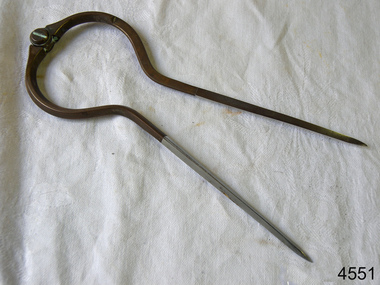
Dividers, Early 20th Century
Dividers are used by navigators to measure the distance between two points on a map or chart. Each point of the divider is places on a map point, then the distance between the points of the divider is measured against the scale of the chart or map. This helps determine the ship's path of travel, the distance travelled and the current location.Not very significant as not associated with any historical event or person, same pattern of dividers is available today from many retail outlets. Also item was probably made around 1940s to 1950sDividers; brass navigator's dividers with fine, stainless steel points. Made in Britain by W & H C (inscription). This navigational tool is used by a ship's navigator to mark the ship's position. Each end point of the divider is placed on a position on a chart or map, then the length between the points of the divider is measured on the chart's scale.Inscribed "British Made" and "W & H C". flagstaff hill, warrnambool, shipwrecked-coast, flagstaff-hill, flagstaff-hill-maritime-museum, maritime-museum, shipwreck-coast, flagstaff-hill-maritime-village, navigational dividers, navigational tool, dividers made by w & hc, w & hc britain -
 Vision Australia
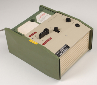
Equipment - Object, Specto Ltd, Clarke and Smith talking book machine with tapete
In 1965 the Clarke & Smith Talking Book Cassette Cartridge made it's debut at the Olympia Show. Popularly known as a 'tapete', it weighed considerably less than the earlier book cassette cartridges and allowed for up to 6 tracks (13 hours recording time) to be played.Clarke and Smith talking book cassette cartridge player consisting of plastic rectangular case with buttons for navigational controls, light green front and top of machine and darker green on sides, power cord and 5 buttons. Also includes tapete "Words for murder perhaps" by Edward Candy and ready by Stanley Pritchard.Clarke & Smith Track change Play -- Off Volume Phones This equipment remains the property of the Braille & Talking Book Library, 31-51 Commercial Road, South Yarra, 3141. Phone: (03) 267 6022 Dyna Tape labels: J21075 Play Rewindaudio equipment, clarke and smith -
 Nhill Aviation Heritage Centre
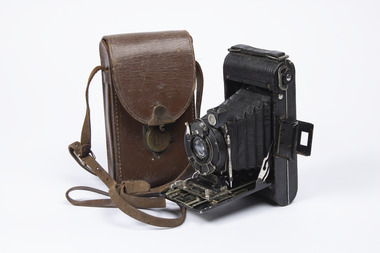
Memorabilia - Camera and case, No.1 Pocket Kodak Special, 1922 to 1931
This camera belonged to Stan Guilfoyle who was a wireless operator air gunner (WAG) here at Nhill Air Navigation School, December 1943.This item is of great significance being here at the air school during it's operation. Some of the photos in Kevin O'Reilly's book In Just Five Years were taken with this camera. Folding Kodak Camera, metal casing with paper concertina folding body and lens assembly, comes with leather carry case. Has various lens adjusters and a scribing pin attached.Kodamatic, No.1 Pocket Kodak Special, Made in USA by Kodak Company Rochester NY, 26980camera, kodak, guilfoyle, stan guilfoyle, wag, -
Moorabbin Air Museum
Manual (Item) - Overhaul & Repair Manual For Wirraway
Description: 44 pages. Published by Delco Electronics. Published May 1977. Carousel Navigation System Pilot's Guide. Level of Importance: World. -
Moorabbin Air Museum
Manual (Item) - Armstrong-Whitworth Argosy 650 Series Illustrated Parts Catalogue Volume 5, AW. 650 Aircraft Manual
Topics include flight controls, fuel, hydraulics, ice and rain protection, instruments, landing gear, lights, navigation, oxygen, and water/waste.