Showing 10609 items
matching sites
-
 Federation University Historical Collection
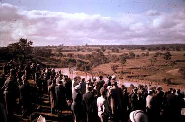
Video Presentation, Alan Keeley, The Eureka Stockade Site by Jack Harvey, 1993, 19/10/1993
MP4 File of a presentation by Jack Harvey on the Site of the Eureka Stockade. ballarat, eureka stockade, eureka stockade site, jack harvey, alan keeley -
Glenelg Shire Council Cultural Collection
Photograph - Photograph - Lee Breakwater, Portland, n.d
Port of Portland Authority Archivesport of portland archives, tanker berth, construction -
Glenelg Shire Council Cultural Collection
Slide - Slide - Cashmore Airport, Portland, 1980s
portland airport, cashmore airport, construction, air travel -
 Bendigo Historical Society Inc.
Slide - DAVID MCDONALD COLLECTION: EPPALOCK. CONSTRUCTION, c1960
Eppalock. Construction. Viewing the opening . Markings: Eppalock Dam SiteKodakcivil engineering, water supply, eppalock -
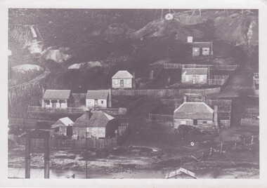 Clunes Museum
Photograph
BLACK AND WHITE PHOTGRAPH OF MINERS' COTTAGES NEAR A MINE SITElocal history, photography, photographs, mining -
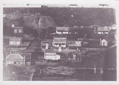 Clunes Museum
Photograph
BLACK AND WHITE PHOTOGRAPH OF MINERS' COTTAGES NEAR A MINE SITElocal history, photography, photographs, mining -
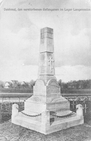 Stawell Historical Society Inc
Photograph, War memorial at Langensalza sent by Ray Membrey
Photograph of the War Memorial at Langensalza. The post card was sent by Ray Membrey from the P.O.W. camp 3.7.1917. Post card of War Memorial at Langensalza set in a grave site.Denkmal, den versiorbenen Gefangenen lm Larger Langensaiza Written on the back of the post card. "3 July 1917 I am doing well. Raymond addressed to Mrs. Membrey Skene St Stawell Victoria Australia." stawell ww1 -
 Rutherglen Historical Society
Document, 13/02/1998
When operational, the Gold Battery used cyanide in its processing processes. The land surrounding it required remediation before it could be handed over to Indigo Shire for public use. The land has since been planted with pasture and native plants. The Gold Battery has been restored to working condition, and can be viewed by collecting a ticket from the Rutherglen Wine Experience and Visitor Information Centre.Photocopy of letter relating to remediation works on the Gold Battery site.gold battery, gold processing, land remediation -
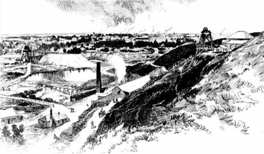 Ballarat Heritage Services
Photograph - Image - Black and White, Ballarat From Black Hill, 1888, 1888
Image of a mining site on Black Hill, with the township of Ballarat in the background. black hill, mining, poppett head, black hill flat -
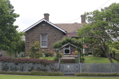 Ballarat Heritage Services
Digital photograph, Lisa Gervasoni, Bluestone House, Portland, 2016, 30/12/2016
Photograph of a bluestone house near the site of the former Immigration Depot.portland, heritage, bay, water, beach, bridgewater -
![Vehicle - HMAS Lonsdale [HMVS], Built in 1884](/media/collectors/4f729f7e97f83e03086018d1/items/4fd575aa2162ef0ecc023165/item-media/613b16c26b487cd5e2ab7cba/item-fit-380x285.jpg) Queenscliffe Maritime Museum
Queenscliffe Maritime MuseumVehicle - HMAS Lonsdale [HMVS], Built in 1884
Transported to Victoria as deck cargo aboard s.s. Port Darwin. This vessel was ordered by Government of Victoria and was only used in training exercises in Port Philip and had become outmoded by the time the Royal Australian Navy was formed in 1911.Buried by sand in the grounds of the Queenscliffe Maritime Museum. There is no known record of how the "Lonsdale" ended abandoned on the beach at Queenscliff. Originally the land where the QMM is situated was the foreshore at the back of the houses in Beach Street, Queenscliff. There were two Torpedo boats built in 1884, the Lonsdale and the Nepean.Site of the buried remains of the Torpedo Boat HMAS Lonsdale [HMVS]hmas lonsdale, hmvs lonsdale, victorian navy, port phillip, royal australian navy -
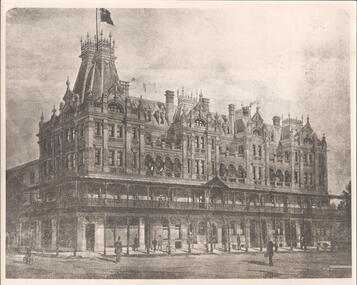 Bendigo Historical Society Inc.
Photograph - SHAMROCK HOTEL COLLECTION: PHOTOGRAPH. SHAMROCK HOTEL
Photograph. Shamrock Hotel - third building on the site. Two Copies -
 Stawell Historical Society Inc
Photograph, Sloane's & Scotchmans United Quartz Mining Company Remains with collapsed Poppet Head and Engine Mounts
Sloane's & Scotchman Mining Co remains with collapsed Poppet Head and Engine Mounts.Derelict mine site with engine housing brickwork and Mullock heap. mining -
University of Melbourne, Burnley Campus Archives
Plan - Photocopy, Burnley Site, c.1940
Part B. Photocopy of plan of site with proposed changes marked on it.burnley -
 University of Melbourne, Burnley Campus Archives
Photograph - Black and white print, Commercial Photographic Co Pty. Ltd, Administration Building, c. 1949
2 copies. Administration Building completed, site cleared but no planting. On reverse, "Commercial Photographic Co Pty. Ltd. 217 Queensberry Street, Carlton, Melbourne, N.3 FJ5266 When ordering further prints please quote No K.370-7."administration building, completion -
 Melton City Libraries
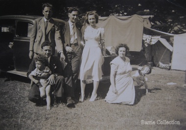
Photograph, Edna and Bon's family camp trip at Apollo Bay, 1948
Wendy Barrie's memories of Apollo Bay The camping trips were a yearly event after the harvest had finished. The trip down to the beach was a much-anticipated event heading out through Parwan and to Geelong leaving behind the hot and dusty plains and our parents relieved to have the hard work of harvesting left behind. The Otways in the distance were reached with great anticipation, Mum in the car and Dad in the Truck ahead of us anxiously winding through the narrow roads and negotiating the hairpin bends and breathing in the cool fresh air of the forest, and keeping an eye out of the log trucks that might come sweeping the corner. The tree ferns with their dripping moisture and the giant trees and the unmistakeable small of the eucalypts. Great excitement was when we caught our first view of the sea from the highest point of the road and then is was the cautious drive the sea level to the sight of the blue ocean with the white of the waves crashing on the rocks and the pristine sand. The water from the Wild Dog and Skenes creek trickling onto the ocean. The tree ferns with their dripping moisture and the giant trees and the unmistakeable smell of the eucalypts. The return journey was usually taken on the Great Ocean Road, it was considered safer to be on the inside of the road. In the early days it was very narrow and passing oncoming cars was taken very cautiously. Landslides and floods sometimes meant we would take the inland route. One year the bridges were washed away and bailey bridges were erected to keep the road open. Rock falls off the cliffs were common Stops on the way home gave us our last chance for our feet in the sand and a swim in the ocean. By the time we reached the hill at Angle Sea the vast blue ocean was behind us and we trekked back through Geelong- Bacchus road and the plains of stubble and the dry grass, and sometimes evidence of burnt patches from a bush fire. The closest we came to a pool at home was the concrete sheep trough at the gate to the work sheds. It was filled with bore water pumped from the nearby windmill. Edna, Bon and their family members at their camp site in Apollo Baylocal identities -
Clunes Museum
Plaque - PRINTING PLATE, Stoney Creek School, map of Australia made by students with stones
METAL PRINTING PLATE WITH IMAGE OF THE SITE OF STONEY CREEK SCHOOLlocal history, documents, newpaper, publishing, schools, stoney creek -
Canterbury History Group
Ephemera - A lady in waiting, {2004}
Real estate advertisement for the sale by auction of 37 Alexandra Avenue, Canterbury on 21 February {2004}. Includes coloured photograph of the exterior of the house and floor and site plans.canterbury, alexandra avenue, lead lights, verandahs, californian bungalows -
Canterbury History Group
Ephemera - "Braemar" 15 Wentworth Avenue Canterbury, [2002]
Real estate advertisement for the sale by auction of "Braemar" 15 Wentworth Avenue Canterbury on Saturday 23 November [2002]. Includes a coloured photograph of the exterior of the house and floor and site planscanterbury, wentworth avenue, golden mile, californian bungalows -
Federation University Historical Collection
Book - Report, Former Ballarat Brewery Conservation Analysis, 1994, 1994
The former Ballarat Brewery site was purchased by the Ballarat School of Mines in 1993 who commissioned the conservation management plan. It has closed as a brewery in 1989 and the plant and fittings auctioned. The buildings were demolished and a new educational facility known as the brewery Complex was built, using some elements of the former brewery in its design. 124 page report copied onto A4 white paper, with additional appendices and definitions. Contents include brewing in Australia, site history, Tulloch & McLaren Royal Standarg Brewery, Henry Caselli, Ballarat Brewing Company, Physical Survey and comparitive analysis.ballarat school of mines, henry richards caselli, henry caselli, chimney, ballarat brewery, carlton and united breweries, tulloch and mclaren, henry r caselli, ballarat brewing company, cub, brewing tower, brew tower, boiler and engine room, cooling tower -
 Federation University Historical Collection
Plan, Ballarat School of Mines Building Development, 11/04/1964
With the development of tertiary education in the 1960s and 1970s the Ballarat School of Mines asked Coburn and Associates to design new buildings for the Ballarat School of Mines site, utilising the Ballarat Gaol site. The plans did not proceed, with the Mount Helen Campus being created instead. For information on Herbert L. Coburn go to http://guerin.ballarat.edu.au/curator/honour-roll/honourroll_Coburn,%20H.L.shtmlThree copies of plans by Coburn and Associates, with hand applied colour. The plans relate to a proposed development of the Ballarat School of Mines. .1) - shows the Ballarat School of Mines site, with proposed new buildings. It also shows buildings along Dana Street including the Ballarat Club, as well as White Flat. .2) View of proposed Library and Union Building .3) View of proposed Engineering Buildinguniversity of ballarat, ballarat school of mines, architect, herbert coburn, herbert l coburn, coburn and associates, architectural plans -
 Bendigo Historical Society Inc.
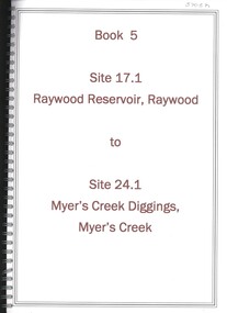
Book - RAYWOOD RESERVOIR RAYWOOD TO MYER'S CREEK DIGGINGS MYER'S CREEK, 1992
Book 5 - Site 17.1 to Raywood Reservoir, Raywood to Site 24.1, Myer's Creek Diggings, Myer's Creek. Significance reports prepared for North Central Goldfields Project: Bendigo Goldfield .David Bannearbendigo, mining, goldfields report, bendigo, gold, goldfields, history, report -
Bendigo Historical Society Inc.
Photograph - ELMORE FIELD DAYS
Elmore Field Days were first held in 1964.Aerial photograph of Elmore Field Days site. Undated but possibly 1969-1970. Image shows exhibitor stands, roadways and parked vehicles. Oh LH side of image is a water course, an anabranch of the Campaspe River. Site is now a camping reserve as the Elmore Field Days is now (2022) held at a nearby site.event, agriculture, elmore field days -
University of Melbourne, Burnley Campus Archives
Plan, 36 Railway Ave, Armadale, 1991-1997
Sets of plans for a Residential Garden produced by students for an assignment. (1) Tracing paper and paper copies site plan sketch. (2) Janine Bugg - Assessment Preliminary Plan, Concept Plan, Site Inventory and Analysis, Site Elevation A, Section Elevation B dated 26.05.1994. (3) Carmen Skrobonja - Assessment Main Plan & Section Elevation, Concept Plan dated 31.05.1991. (4) G. Mutimer - Preliminary Plan, Section Elevation, May 1994. (5) Melissa King - Assessment, Site Inventory & Analysis, Site Concept Plan, Preliminary Main Plan, Section Elevation, May 1997. (6) Jim Despotellis - Site Inventory & Analysis, Concept Plan, Preliminary landscape Design, 25.04.1994 - 15.05.1995. (Also see B11.0775.) (7) 33 Railway Ave (sic), Colour photographs pasted on paper. (8) Marli Draper - Site Inventory and Analysis, Concept Plan, Preliminary Plan, Perspective Feature Bed. (Also see B11.0773). (9) Cowan (Creations) - Site Inventory and Analysis, Concept Plan, Preliminary Plan, Assessment, 30.05.1994. (10) McRae (Designs) - Site Inventory and Analysis, Preliminary Main Plan, Concept Plan, Section View to Tussock Grass and Eucalyptus, 30.05.1997 - 01.06.1997. (11) Leah Syme - Site Inventory and Analysis.armadale, janine bugg, carmen skrobonja, melissa king, jim despotellis, marli draper, leah syme, g. mutimer, students, assignments -
 City of Moorabbin Historical Society (Operating the Box Cottage Museum)
Photograph - Photograph, 1908 Excavation commences for the Melbourne Benevolent Society, Cheltenham, 1908 Excavation commences for the Melbourne Benevolent Society, Cheltenham, 1908
Excavating prior to the building of Melbourne Benevolent Society in Cheltenham. The Centre had begun life in 1850 in Melbourne, as the Victoria Benevolent Asylum to "relieve the aged, infirm, disabled and destitute poor of all creeds and nations and to minister to them the comfort of religion" It outgrew its North Melbourne premises so was located to a new site at Warrigal Road, Cheltenham. The foundation stone was laid in 1909, and the main buildings were completed in 1911. In 1970 the benevolent Asylum was re-named Kingston Centre. The photograph is black and white. It's a photo depicting the excavation prior to the building of Melbourne Benevolent Society in Cheltenham. The photograph shows eleven workers at the excavation site. There are two horses with carriages and a large excavating machine to the right of the photograph. benevolent asylum, benevolent society, cheltenham, train, machinery, men, society, horses, kingston centre -
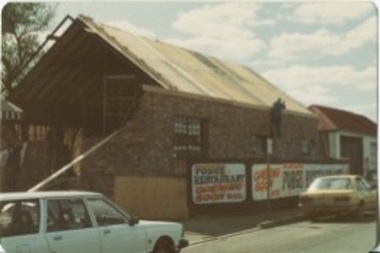 Kilmore Historical Society
Photograph, 69 Sydney Street, 1982
13cm x 9cm coloured photograph of the construction site where the old forge was at 69 Sydney Street. The brickwork is almost complete and the so is the roofing. There are fences around the construction site advertising "Forge Restaurant Coming Soon B.Y.O" and "Coming Soon Forge Restaurant B.Y.O". Now is the site of the Kilmore Palace Chinese Food.restaurants, construction sites, construction -
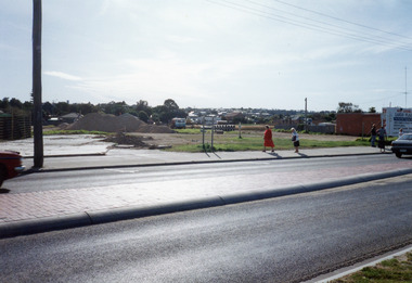 Lakes Entrance Regional Historical Society (operating as Lakes Entrance History Centre & Museum)
Photograph - Safeway Supermarket, Holding M, 1994
Date made May 1994Colour photograph of the old Carnival site, Esplanade, showing preliminary work on site of Safeway Supermarket. Pile of sand and soil, tip truck and pile of large diameter pipes on site. Five people on footpath beside highway which has tiled traffic island division. Township houses in the background. Lakes Entrance Victoriatownship, transport, retail trade -
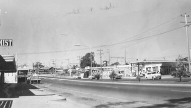 Ringwood and District Historical Society
Photograph, Maroondah Highway west, Ringwood- 1965. Easterly view towards Esso petrol station and cool stores on opposite corners of Wantirna Road
Black and white photographWritten beneath photograph, "1965 - Looking east to old cool store site." Written on rear of backing sheet, "1965. Cool store site, corner Maroondah Highway and Wantirna Road". -
 Kew Historical Society Inc
Photograph - Denmark Street, Kew, 1972
The Engineer's Department of the former City of Kew had an extensive collection of photograph of sites in Kew requiring documentation to inform public works. It also kept images of engineering practice in other parts of Melbourne, and overseas, that could be used as models for local activity. Many of these photographs (and plans) were donated to our collection in the 1980s. A number of the photographs are annotated, either on the image itself or on the reverse.This photograph, and others sourced from the City Engineer's Department of the former City of Kew, qualifies as an important record of local streets, public works, street beautification, and engineering techniques of the period. Original black and white photographic positive of automobiles and buildings in Denmark Street, Kew, immediately before the road enters Kew Junction. On the left is McKeon Motors and a retailer of Insulwool, while in the distance is the pharmacy on the corner of High Street and Princess Street (later demolished during the widening of Kew Junction). Notable are the bluestone guttering and what appears to be vacant land on the apex of the triangle of land bounded by High Street South, Denmark Street and Barkers Road. This site was the original location of O'Shaughnessy's 'Kew Hotel', and after the destruction by fire of the latter, the location of a service station. [It is now the site of the Cresco Reserve].Annotation verso: "Indicating the existence of a vehicular entrance at Denmark St abuttal of No.188 High St prior to reconstruction of channeling &c 1972."denmark street -- kew (vic.), kew junction, luestone gutters, mckeon motors, insulwool -
Lakes Entrance Regional Historical Society (operating as Lakes Entrance History Centre & Museum)
Photograph, M Holding, 2006
Also a colour photograph of Telstra building enclosed by security fence and shrubs Barkes Avenue 04283.1 size 10 x 15 cmColour photograph of R S L Anzac site in Barkes Avenue showing small brick building and cleared grounds enclosed by security fence site of earlier guesthouse Lakes Entrance Victoriabusinesses, township