Showing 659 items matching " survey plan"
-
 University of Melbourne, Burnley Campus Archives
Photograph - Black and white print, Alfred Lynch, Plan of the Experimental Gardens, 1861-1991
Colour and black and white photographs of the original plan for the Ornamental Garden and Orchard in the Survey Paddock by Alfred Lynch in 1860 for the Horticultural Society of Victoria. See B92.630.experimental gardens, alfred lynch, plan, burnley gardens, ornamental garden, orchard, survey paddock, horticultural society of victoria, hsv -
 University of Melbourne, Burnley Campus Archives
Plan, Burnley Gardens. City of Richmond. Parish of Jika Jika - County of Bourke, 1927
Part-coloured plan showing drainage, sewerage drains, taps and waterstops. Area bounded by Swan St. To N, Yarra River on E and Richmond Park on SW side. Contour lines of orchard depicted, laying pens and yards. Coloured area depicts pavilion with surrounding garden and paths layout pencilled in. Photo-Lithograph by Dept. of Lands & Survey, Melbourne by W. Butsonsewerage, drainage, lithograph, pavilion -
 University of Melbourne, Burnley Campus Archives
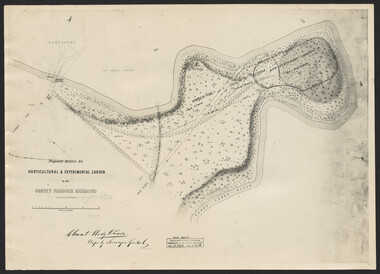
Photograph, Clement Hodgkinson, Proposed Reserve for Horticultural & Experimental Garden in the Survey Paddock, Richmond, 1862-1948
Photograph dated 7.12.48 of plan by Clement Hodgkinson, Deputy Surveyor General. Gazetted 1/8/62, handwritten on it in pencil.clement hodgkinson -
 University of Melbourne, Burnley Campus Archives
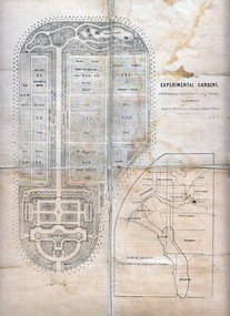
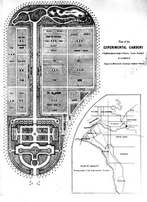
Plan, Alfred Lynch, Plan of the Experimental Gardens of the Horticultural Society of Victoria. Survey Paddock. Richmond, 1861
... of the Horticultural Society of Victoria. Survey Paddock. Richmond Plan Alfred ...Subsequently the area was not fully developed in this manner following flooding in 1863. Some remnants remain.Plan on paper with cloth backing. Inscription, "Designed by Alfred Lynch. Landscape Gardener, Prahran. Printed by De Guchy & Leigh." An inset plan shows position of Experimental Gardens related to the City of Melbourne and Bay. Plan shows layout and plantings of the designated area - fruit, vegetables: the conservatory, nursery, exhibition buildings. This plan was owned by E.E. Pescott. Inscription on cover, "Burnley. E.E.P.." "Ed. E. Pescott." Subsequently the area was not developed in this manner. See inscription on copy made for Centenary Exhibition B92.633. Other copies given to College by N. Lothian (graduated 1934). Jim Sanders, a friend of his, gave them to Dr. G. Moore in 1991. A larger copy, inscribed on reverse, '1861', 'Early proposals for Horticultural Gardens for Horticultural Society of Victoria (now Royal). The lithograph was included as an insert in the Farmers Journal and Gardeners Chronicle 21 June, 1862. It is only in one of the copies held by the State Library of Victoria. 1 large and 1 small photographs of plan. Several photocopies of the plan.Inscription, "Designed by Alfred Lynch. Landscape Gardener, Prahran. Printed by De Gruchy & Leigh." / Inscription on cover, "Burnley. E.E.P.." "Ed. E. Pescott."alfred lynch, experimental gardens, conservatory, nursery, e.e. pescott, n. lothian, jim sanders, dr. g. moore, horticultural socoety of victoria -
 University of Melbourne, Burnley Campus Archives
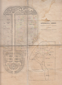
Plan, Plan of the Experimental Gardens of the Horticultural Society of Victoria. Survey Paddock. Richmond, c.1860-1862
... society of victoria plan Copy of Plan B92.0632 laminated for use ...Copy of Plan B92.0632 laminated for use in the Centenary Exhibition of 1991 at Burnley College.experimental gardens, horticultural society of victoria, plan -
 University of Melbourne, Burnley Campus Archives
Plan, Rainforest Garden Development VCAH Burnley, 1990-1992
Some of these plans were held in P. Tulk's office, used by Honours Student, Linda Hipwell in 1999. (1a) Rough sketch on tracing paper. (1) Rainforest Project drawn by G. Olive, rough sketch pen and pencil on paper. (2) 1 tracing paper and 2 paper copies, Rainforest Garden Development Plant Schedule Key by type of plant. (3) Blueprint of Rainforest Garden Development, plant names beside plants, note to P. Tulk from J. Kellow. (4) Native Garden Burnley VCAH Hort Eng. II. Surveying by Gail, John, Rebecca, Sean, Tim (Students). g. olive, phil tulk, linda hipwell, vcah, students, rainforest, gardens -
 University of Melbourne, Burnley Campus Archives
Plan, Yarra 500/045.043 Municipalities of Prahran 211 and Richmond 207, 1979
Melbourne and Metropolitan Board of Works Series 1:500. Map prepared by the Survey Division, MMBW January 1979. Scale 1:500. Area surrounding Heyington Station and St. Kevin's Junior Schoolmelbourne and metropolitan board of works, prahran, richmond -
 University of Melbourne, Burnley Campus Archives
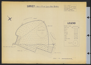
Plan, Survey: Site 1 - Front Lawn, Main Building, 1985
Plan of Front Lawn area with legend. V.C.A.H - Burnley Horticultural Engineering Surveying Exercise dated 10.09.1985. Group Members: T. Allworth, M. Appleby, B Barker (Student: Mary Appleby). Scale 1:100.vcah, lawns -
University of Melbourne, Burnley Campus Archives
Plan, Kirsten Strutt, Central Gardens Hawthorn, 1996
Plans by Kirsten Strutt (student) for Hawthorn City Council. Scale 1:500. (1) Site Analysis September 1986. (2) Tree Survey October 1986 Drawing No 2.kirsten strutt, hawthorn, gardens, central gardens hawthorn -
University of Melbourne, Burnley Campus Archives
Plan, [Historical Maps of Richmond Park], 1862-2000
(1) Proposed reserve for Horticultural & Experimental Garden in the Survey paddock Richmond. R.19A (1865). Shows Swan Street Extension. Gazettals 1877, 1887. (2) As (1). Half of map only Annotation by A. Purchas, 9 October, 1862. (3) Plan of Richmond park. A.L. Martin Authorised Surveyor, 31st August, 1872. [Dept. of lands & Survey Melbourne, J. Noone, 6th September 1872.] Map in 4 sheets. (4) Richmond Park. Surveyed by Geo. Black, Authorised Surveyor 13.8.91 (2 copies). (5) [Richmond Park] Shows road alignments gazetted 1871 & 1881 (part copy only - Neg. 18375). (6) City of Richmond Parish of Jika Jika County of Bourke. Department of lands & Survey, 1919 (annotations i.e. Melb. City Link, Amrad, etc. to 1994.) (7) Burnley gardens, 2000. Produced by P. Tulk, Institute of Land & Food Resources, Burnley College, 2000 (re area proposed for heritage listing.)richmond park, survey paddock -
University of Melbourne, Burnley Campus Archives
Plan, Plan of the Zoological and Acclimatisation Society of Victoria, Royal Park, Melbourne, c. 1884
Copy of plan held at the State Library of Victoria surveyed by G. Purchas, possibly 1884. Possibly based on the winning competition entry by Alfred Lynch 1861 (See B17.0076). Also see B18.0030 Plan drawn by Caroline Le Souef.caroline le souef, alfred lynch, zoological and acclimatisation society of victoria, royal park, g. purchas -
University of Melbourne, Burnley Campus Archives
Map, Plan of Early Melbourne Showing Original Crown Allotments, c. 1852
... , and a portion of Prahran Compiled from the Government Plans and Private... the Government Plans and Private Survey by William Green.' (2 copies, one ...Copy of 'Map of the City of Melbourne, and its Extension, together with Collingwood, Richmond, Hawthorne, the Emerald Hill, and a portion of Prahran Compiled from the Government Plans and Private Survey by William Green.' (2 copies, one enlarged)melbourne, william green, richmond, hawthorne, collingwood -
University of Melbourne, Burnley Campus Archives
Plan, Royal Horticultural Society's Garden
Changed boundaries of the site burnley gardens, survey paddock, flood, lynch design, richmond park, yarra river -
![Plan, University of Melbourne Burnley Campus Institute of Land and Food Resources Formerly known as the Royal Horticultural Gardens Burnley [sic], 2001](/media/collectors/52f2d90c9821f4163875a333/items/6145823c174069677c22f6e6/item-media/65ef8feeb2201fddf6999498/item-fit-380x285.jpg) University of Melbourne, Burnley Campus Archives
University of Melbourne, Burnley Campus ArchivesPlan, University of Melbourne Burnley Campus Institute of Land and Food Resources Formerly known as the Royal Horticultural Gardens Burnley [sic], 2001
site plan, buildings, planrs -
Canterbury History Group
Document - School Project: A history of 137 Mont Albert Road, Canterbury, Rush, Anne-Marie
... since it was built in 1890. includes 2 pages of plans.... includes 2 pages of plans of Elgar's Special Survey Document School ...A research paper for the Australian History option describing the history of 137 Mont Albert Road, Canterbury. The writer looks at the lives of various owners, particularly Henry Elgar and Richard Quittenton, and how the house has changed since it was built in 1890. includes 2 pages of plans of Elgar's Special Surveycanterbury, mont albert road, "haslemere", quittenton> richard, elgar> henry, elgar's special survey, boroondara estate -
Tarnagulla History Archive
Set of Maps (Mining & Local Area), various
David Gordon Collection. A set of mining documents, maps and plans: 1. Dunolly Deep Leads - showing location and names of deep lead gold deposits in region around Dunolly including at Tarnagulla and Newbridge. Geological Survey of Victoria, Department of Minerals and Energy. Bulletin No. 62, Map No. 4 Dunolly (770 x 485 mm). 2. Poseidon Lead (Facsimile) 3. Nick O Time Lead (Facsimile) 4. Happy Go Lucky Mine prospectus and plan (colour copy) 5. Jones Creek GM Co. (Raven & Gourlay's) Waanyarra - Prospectus (colour copy) 6. Poseidon Area Plan (colour copy) and Poseidon Area map (B&W copy). 7. Cross-section diagram of Spread Eagle Reef 8. New Birthday Gold Mine - area map (colour copy) and mine cross-section ( (colour copy). 9. Cross section of Poverty Reef, by Department of Mines (B&W copy, 2 parts on A2 paper) 10. Time-Lease Graph for Watts Reef, Specimen Reef, Stony Reef, Poverty Reef (second page in detail), created by Eric WIlkinson for Ref Mining NL, 1995 11. 1859 Plan of the Gold Workings & Township of Sandy Creek, Shewing the Mining Leases, Extended Claims & Machinery by R.J. McMillan, Mining Surveyor (B&W copy) 12. Longitundinal and Transverse Vertical Sections of Poverty Reef, Sandy Creek 1859, by R.J. McMillan, Mining Surveyor (B&W copy) 13. Tarnagulla Locality Plan (B&W copy) 14. Universal Grid Reference Map (Topographic) for Laanecoorie North (2 copies) 15. Universal Grid Reference Map (Topographic) for Inglewood South 16. Poverty Reef, Plan showing shafts and early tenements, created by Eric WIlkinson for Ref Mining NL, 1995 17. Locality Map of mining leases in Tarnagulla 18. Plan and Elevation of part of Poverty Reef, Sandy Creek, showing the claims and positions of the shaft. by R.J. McMillan, Mining Surveyor (Facsimile, composed of taped together components) 19.Plan and Elevation of part of Poverty Reef, Sandy Creek, showing the claims and positions of the shaft. by R.J. McMillan, Mining Surveyor (Facsimile, composed of taped together components) -
 Wodonga & District Historical Society Inc
Map - Boorgunyah - "The Town that never was"
At the height of the river trade, there was a town surveyed and laid out, and streets were named. This town was to house the workers at the river port of Red Bank when the paddle steamers plied the Murray River as far as Albury, carrying produce such as wool and wheat to the various towns along the river in the 1800s. As the river trade died away, this town never went ahead – one might say, “The town that never was.” A lone gum tree stands on the site today.This item is significant because it documents plans which were made for the early development of Wodonga.A black an white map depicting the proposed location of the township. The map is based on a sketch and is not to scale,early wodonga, boorgunyah - "the town that never was", wodonga heritage -
 Melbourne Legacy
Document, Topic 1 - "How wide the beam?": Introductory statistical paper
1973 comprehensive statistical survey of likely numbers of Legatees, widows and children projected for 15 years, by W.K. Roberts, an Actuary at AMP, Melbourne. This was commissioned in order to consider the future of Legacy at a meeting in Hobart on March 24, 1973. The paper is identified as Appendix E, but the document it is appended to is missing. For the first time figures included the post 1945 conflicts, making the decline in child numbers more gradual, increasing the widow numbers more steeply, and predicting that Legatee numbers would be maintained until 1983 with the caveat that their capacity would change as they aged. Pinned to the printed survey is an anonymous handwritten note giving the number of children in residence at Harelands, Stanhope and Blamey House in 1972-4.Part of the history of Melbourne Legacy's involvement with residential care for children, indicating their awareness of the need to plan for the future.01666.1 White printed double sided sheets, black on white. 01666.2 Yellow copy paper with handwritten text in blue ink. residences, review, blamey house, harelands, stanhope -
 Whitehorse Historical Society Inc.
Manual - Government (Lands Dept), Royal Historical Society of Victoria, The Lands Manual - A Finding Guide to Victorian Land Records 1836 - 1983, March 1989
The manual documents the archives of the Department of Crown Lands and Survey (Lands Department) between 1836 to 1983 and explains how they can be used for historical research.The manual documents the archives of the Department of Crown Lands and Survey (Lands Department) and explains how they can be used for historical research.The manual documents the archives of the Department of Crown Lands and Survey (Lands Department) between 1836 to 1983 and explains how they can be used for historical research.crown lands, victoria. department of crown lands and survey -
 Bendigo Historical Society Inc.
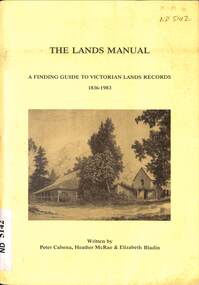
Document - LANDS OFFICE, - INDEX TO CROWN LANDS SURVEYED AND SOLD IN THE DISTRICT OF SANDHURST
Document: Buff hard cover book, with fawn coloured binding on spine (later addition to mend spine?) On front cover drawn in black pen ' PLANS' and 'Index Book' On spine written in black ink ' plans index book'. Contains index of parishes in front of journal with 470 pages indexed to parishes. Double page entries: LH side page: town, suburban or country lands, total lands surveyed. Date of survey. RH page: allotment, section, particulars, no. page. Entries are not dated.Lands Officeland sales, lands office, land surveyed , land sold, bendigo, sandhurst -
 Bacchus Marsh & District Historical Society
Map, Plan of land purchased by the Bacchus Marsh Shire Council from Mr. T. Low for a deviation of the Melbourne to Ballarat main road. 1877
The date of this plan is 1877 and the land indicted on it required for a road deviation is shaded in blue. It adjoins the Korkuperrimul Creek on one side which indicates the land is located just a few kilometers to the west of Bacchus Marsh. Single page map showing a portion of land purchased by the Bacchus Marsh Shire from Mr Thomas Low for the purpose of a road deviation. Land held by David Robertson is also shown on the map. Scale: 2 chains to 1 inch. Part of a set of maps which are pasted into a bound volume containing 76 maps or plans in total. High resolution digital image stored on BMDHS computer network. Surveyed by W. E. Standfield, Shire Engineer, Bacchus Marsh, 12/4/77bacchus marsh roads and streets, melbourne to ballarat road -
 Bacchus Marsh & District Historical Society
Map, Village allotments, Parish of Myrniong, County of Bourke
... Parish Plan Myrniong Parish Maps Surveyed by John Hardy, Surveyor ...Myrniong is a village 9 kilometers west of Bacchus Marsh. Prior to 1863 the area was known as Blow's Flat. This map which was produced in 1903 and according to the catalogue record of this map held at the State Library of Victoria was based on an earlier map created in 1861. The early layout of streets for the village of Myrniong can be seen on this map. The streets shown are, Main Street, Hardy Street, Blow Street, Myrniong Street, Shuter Street, and Blackwood Street. An area marked as a reserve for a school can be seen between Hardy Street and Main Street.A single page paper map. A cadastral parish map of Myrniong in Victoria, showing numbered land allotments. Photo-lithographed at the Department of Lands & Survey, Melbourne, in 1903. Based on an original map created in 1861. The map is pasted into a bound volume containing 76 maps or plans in total. High resolution digital image stored on BMDHS computer network. Surveyed by John Hardy, Surveyor ; photo-lithographed at the Department of Lands & Survey, Melbourne by T.F. McGauran, 24.12.03myrniong parish plan, myrniong parish maps -
 Bacchus Marsh & District Historical Society
Map, Parwan Parish Map, County of Grant, 1909
A single page paper map showing the map for the Parish of Parwan in the County of Grant. A cadastral map showing parish boundaries and land ownership. The map is pasted into a bound volume containing 76 maps or plans in total. High resolution digital image stored on BMDHS computer network. Photo-lithographed at the Department of Lands and Survey, Melbourne by T.F. McGauran, 7.7.09. bacchus marsh region parish plans, parwan parish maps, parwan parish plan -
 Bacchus Marsh & District Historical Society
Map, Trentham Parish Map 1905 Copy 1
A single page paper map showing the map for the Parish of Trentham in the Counties of Dalhousie and Bourke. A cadastral map showing parish boundaries and land ownership. The map is pasted into a bound volume containing 76 maps or plans in total. High resolution digital image stored on BMDHS computer network. Photo-lithographed at the Department of Lands and Survey, Melbourne by T.F. McGauran 22.3.05 trentham parish maps, trentham parish plan, bacchus marsh region parish plans -
 Bacchus Marsh & District Historical Society
Map, Coimadai Parish Map, County of Bourke. Circa 1890s-1900s
The cadastral Parish of Coimadai, a subdivision of the County of Bourke, lies directly north of the township of Bacchus Marsh. The date of this map is uncertain. T.F. McGauran the person who made a photo-lithographic copy of the map was in charge of photo-lithography at the Victorian Department of Lands and Survey in the late 19th century until about 1910.A single page paper map showing the map for the Parish of Coimadai in the County of Bourke. A cadastral map showing parish boundaries and land ownership. A rectangle shaped area is missing from the centre of the map due to a tear or deliberate excision. The map is pasted into a bound volume containing 76 maps or plans in total. High resolution digital image stored on BMDHS computer network. Photo-lithographed at the Department of Lands and Survey, Melbourne by T.F. McGauran 26.8.[??] NOTE. Photo litho from L.P showing temporary surveys and occupation of land prepared for departmental use onlybacchus marsh region parish plans, coimadai parish maps, coimadai parish plan -
 Bacchus Marsh & District Historical Society
Map, Blackwood Parish Map, County of Bourke, 1892
A single page paper map showing the map for the Parish of Blackwood in the County of Bourke. A cadastral map showing parish boundaries and land ownership. The map is pasted into a bound volume containing 76 maps or plans in total. High resolution digital image stored on BMDHS computer network. Photo-lithographed at the Department of Lands and Survey, Melbourne by T.F. McGauran 14.7.92bacchus marsh region parish plans, blackwood parish plan, blackwood parish maps -
 Bacchus Marsh & District Historical Society
Map, Blackwood Parish Map, County of Bourke, 1905
A single page paper map showing the map for the Parish of Blackwood in the County of Bourke. A cadastral map showing parish boundaries and land ownership. The map is pasted into a bound volume containing 76 maps or plans in total. High resolution digital image stored on BMDHS computer network. Photo-lithographed at the Department of Lands and Survey, Melbourne by T.F. McGauran 21.7.05bacchus marsh region parish plans, blackwood parish plan, blackwood parish maps -
 Department of Energy, Environment and Climate Action
Coloured mapping inks and pens
Coloured ink used to mark lines of paper maps. Could be used in pen or as a "wash" to colour areas with a soft sable hair paint brush Strict cartographic guidance was provided by the FCV’s 1947 publication - “Handbook of Conventional Signs and Symbols for Use in Forest Mapping and Plan Drawing”. It was slow and exacting work but very rewarding.Pelikan coloured inks in small glass bottlesPelikan forests commission victoria (fcv), mapping, forest measurement, surveying -
 Bacchus Marsh & District Historical Society
Map, Myrniong Parish Map, County of Bourke, 1882
A single page paper map showing the map for the Parish of Myrniong in the County of Bourke. A cadastral map showing parish boundaries and land ownership. The map is pasted into a bound volume containing 76 maps or plans in total. High resolution digital image stored on BMDHS computer network. Photo-lithographed at the Department of Lands and Survey, Melbourne by J. Noone, 17.7.82myrniong parish plan, myrniong parish maps, bacchus marsh region parish plans -
 Bacchus Marsh & District Historical Society
Map, Parish of Yangardook, County of Bourke 1876
The parish of Yangardook lies directly north of the township of Melton. The locality of Toolern Vale lies in the centre of this parish. A single page paper map showing the plan for the Parish of Yangardook in the in the County of Bourke. Scale 40 chains to 1 inch. The map is pasted into a bound volume containing 76 maps or plans in total. High resolution digital image stored on BMDHS computer network. Photo lithographed at the Department of Lands and Survey, Melbourne by J. Noone, 1.8.76yangardook parish maps, toolern vale victoria maps