Showing 528 items
matching technical information
-
 Flagstaff Hill Maritime Museum and Village
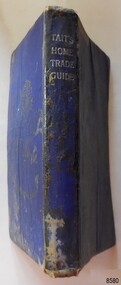
Book - Technical Reference, James Tait, Extra Master and Author et al, Tait's Home Trade Guide to the Board of Trade Examinations for Mates and Masters, 1943
The book includes navigational information, tables and maps, diagrams and formulas. It was written for Examiners and Students studying for their nautical Mates and Masters marine qualifications— notes have been handwritten inside the front and back covers. Notes in point form: 1. I have seen the back of a torpedo EBoat or UBoat in my starboard side 2. I _ _ _ to - - - - - - - - - Port side 3. at a distance ----------- 4. Enemy surface vessel in sight __________ 5. suspicious vessel in sight 6. enemy (undecipherable) 7. I have cut a _ _ _ adrift with my _ _ 8. FI_ _ WISE _ _ _ 9. STARWISE 0. OPEN FIREThis relatively rare book provided up-to-date navigational information during World War II. It was to be used by Examiners to assess whether students qualified to be a Ship's Mate or Ship's Master. The contents of the book were based on maritime knowledge gained over centuries. It is an aid to understanding the navigational methods of the time and the changes and improvements in more recent history.Title: Tait's Home Trade Guide: to the Board of Trade Examinations for Mates and Masters Author: James Tait, Extra Master Publisher: Brown, Son and Ferguson, Ltd. Glasgow, Great Britain Date: Revised Edition 1943 Further Information: Fourteenth Edition 1941, Reprinted Edition 1943. Revised and brought up to date by Captain H. T. Jefferys, Extra Master Printed by Nautical Press, Brown, Son & Ferguson, Limited, 52-58 Darnley Street, Glasgow Hardcover, small book, royal blue cover, silver embossed text on spine. Textbook for Mariners. Includes tables and maps, diagrams and formulas, and navigational information. The inside covers of this book contain handwritten calculations, diagrams and notes that refer to navigation. Notes inside the back cover refer to an enemy vessel and OPEN FIRE.Spint, in silver embossing "TAIT'S HOME TRADE GUIDE" Handwritten inside the back cover "R.A.D. / MOORE / PT. WELCH" Included with the text inside the back cover "Gascoyne" "506" and "RCM"flagstaff hill, warrnambool, shipwrecked coast, flagstaff hill maritime museum, maritime museum, shipwreck coast, flagstaff hill maritime village, great ocean road, james tait, brown, son and ferguson limited, torpedo, open fire, pt welch, vessel gascoyne, e-boat, u-boat, marine technology, world war ii, wwii, ww2, navigation exams, ship's mate, ship's master, wwii textbook, nautical textbook, navigational textbook, examination textbook, world war ii textbook, 1943 nautical textbook -
 Bendigo Military Museum
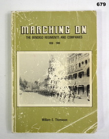
Book, William E Thomason, Marching On - The Bendigo Regiments and Companies 1858-1958
Information on author on back cover: "Born in Bendigo", "lived at St Just Point", "educated at the Long Gully State School and the Bendigo Technical College" "trade milk and cream tester", "served with the Royal Australian Naval Sick Berth Service" and joined the then Bendigo District Ambulance Service in January 1951.Softcover cardboard, black and white print on front, spine and back. Black and white photos on front and back on light olive green background. Quarto bound. 194 pages, plain, illustrated, black and white photos.RSL stamp on front end paper.books, local military history -
 National Vietnam Veterans Museum (NVVM)
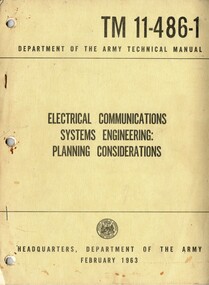
Manual, United States Army, Electrical Communications Systems Engineering: Planning Considerations, 1963
A dark cream coloured cardboad cover with black information on the front. Top right hand corner reads RM 11-4861-1 and under this Department of the Army Technical Manual. The name of the manual is in the middle and at the botton is the insignia of the United States of America War Office with Headquarters, Department of the Army February 1963. There are three punch holes down the left hand side and two metal staples.united states - armed forces - service manuals, department of the army, electrical communications systems engineering, technical manual -
 Bendigo Military Museum
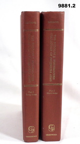
Book - REFERENCE, WEAPONS, Milwauke Public Museum, By order of the Board of Trustees, "THE RUDOLPH J. NUNNEMACHER COLLECTION OF PROJECTILE ARMS", Original print 1928, Reprint 1970
From the Title pages; 1. "The/ Rudolph J Nunnemacher Collection/ of/ Projectile Arms/ Part 1/ LONG ARMS". 2. "The/ Rudolph J. Nunnemacher Collection/ of/ Projectile Arms/ Part II/ SHORT ARMS".1. & 2. Hard cover book. Covers - cardboard, dark orange buckram. Gold colour print on spines. 1. 414 pages, cut, plain, off white colour paper. 'Long Arms', illustrated black and white photographs and technical drawings. Front end paper - handwritten information. 2. 1016 pages, cut, plain, off white colour paper. 'Short Arms', illustrated black and white photographs and drawings.1. Handwritten information - grey lead pencil "$20-".publications, books, reference guide, history, weapons -
 Bendigo Military Museum
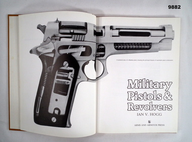
Book - REFERENCE, PISTOLS, REVOLVERS, Ian V Hogg, 'MILITARY PISTOLS & REVOLVERS', 1987
Hard cover book; Cover - cardboard, brown colour buckram, gold colour print on spine. 128 pages - cut, plain, white colour paper. Illustrated black and white photographs and technical drawings. Front end paper - handwritten information. Handwritten information - black ink pen "25/-"publications, books, reference guide, history, firearms -
 Bendigo Military Museum
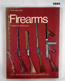
Book - REFERENCE, FIREARMS, Frederick WILKINSON, "FIREARMS", 1974, This edition 1977
Information from front cover; "FIREARMS/ OVER 100 Illustrations of the gunsmith's art".Hard cover book with dust cover. Hard cover - cardboard, red colour paper, white colour print on front and spine. Illustrated - colour photograph of five firearms. Dust cover - paper, description as above for colour, print and illustration. 80 pages, cut, plain, white colour paper. Illustrated black and white and colour photographs, drawings and technical drawings. Front end paper - handwritten information.Handwritten information - blue ink pen, "To Wayne/ Happy Christmas & Happy New Year/ From John and Frances Christmas 1978." Grey lead pencil - "$35"publications, books, reference guide, history, firearms -
 National Vietnam Veterans Museum (NVVM)
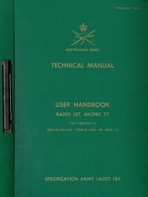
Manual, Australian Army, Australian Army: Technical Manual: User Handbook, Radio Set, AN/PRC 77 (Copy 1)
A green plastic cover with gold information on the front. Top right hand corner reads 7610-66-027-7622. Under the Australian Army insigia reads Technical Manual with the rest of the details under this. The manual is held together by a metal slide.australia - armed forces - service manuals, technical manual, user handbook, radio set an/prc-77 -
 National Vietnam Veterans Museum (NVVM)
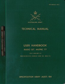
Manual, Australian Army, Australian Army: Technical Manual: User Handbook, Radio Set, AN/PRC 77 (Copy 2)
A green plastic cover with gold information on the front. Top right hand corner reads 7610-66-027-7622. Under the Australian Army insigia reads Technical Manual with the rest of the details under this. The manual is held together by a metal slide.australia - armed forces - service manuals, technical manual, user handbook, radio set an/prc-77 -
 Melbourne Tram Museum
Article, Mal Rowe, "The Birney Safety Car and its use in Australia", 9/1967
The article written by Mal Rowe, looks at the history of the Birney tram in the USA, one-man operations, safety, equipment, costs, accidents, numbers of trams or cars built, and their decline. Looks at the two cars in Melbourne (X class) and the development by the MMTB of the X1 and X2 class cars. Notes their use in other Australian cities - Adelaide, Geelong and Bendigo. Has a table showing their technical details and references. Article printed in the TMSV Running Journal Oct. 1967.Yields information about the Birney Safety car and its use in Melbourne and Australia.Manila folder, with 7 ruled hand written ruled sheets stapled into the folder.tramways, birney trams, tramcars, x class, x1 class, x2 class -
 National Vietnam Veterans Museum (NVVM)
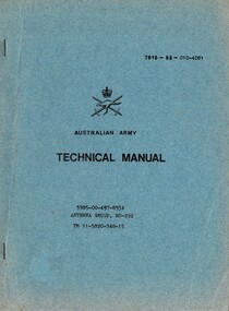
Manual, Australian Army, Australian Army: Technical manual: 5985-00-497-8554 Antenna Group, RC-292 TM 11-5820-348-15, 1966
A blue coloured cardboard cover with black information on the front. Top reads 7610-66-010-4081. The is the Australian Army Insignia with Austrealian Army under it. Technical Manual and further down the cover reads 5985-00-497-8554 Antenna Group, RC-292, TM 11-5820-348-15. The manual is held together with two metal staples down the left hand sideaustralia - armed forces - service manuals, technical manual, antenna group rc-292, australian army -
 Melbourne Tram Museum
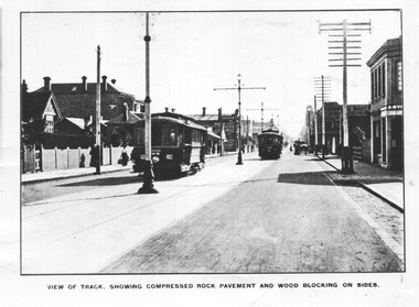
Photograph - PMTT High St Malvern, 1910-1916
Photo probably from a technical journal with the title "View of Track showing compressed rock pavement and wood blocking on sides. Shows two trams in the view. Numbers are blurred.Yields information the assembly of PMTT Tramcars in 1910 at their Malvern Depot.Black and white photograph with notes on the rear.In ink "Prahran & Malvern Tramways Trust. Looking west in High St not far east of Chapel Street between 1910 - 16 when the centre poles were removed. PWD"tramcars, tramways, pmtt, high st, track -
 National Vietnam Veterans Museum (NVVM)
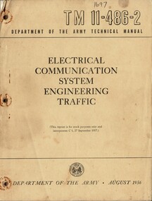
Manual, United States Army, Electrical Communication System Engineering Traffic, 1956
A brownish coloured cardboard cover with black information on the front. Top right hand reads T M 11-486-2 and under this reads Department Of The Army Technical Manual. At the bottom of the cover is the insignia of the United States of Americal War Office with the Department Of The Army . August 1956. There are three punch hles down the left had side and there is evidence that the manual was held together with some form of metal as there are rust areas around the holes. The manual is held together with one rusty staple at the top left hand corner. The manual is stored in a plastic bag.united states - armed forces - service manuals, electrical communications systems engineering, technical manual, department of the army, united states war office -
 Bendigo Historical Society Inc.
Document - LONG GULLY HISTORY GROUP COLLECTION: SOME HISTORICAL INFORMATION
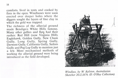
BHS Collection12 photocopied pages. Page four has acknowledgements, Page five mentions Pen-Portraist by Raly Wallace and Kevin Vallence, Page 14 mentions some rich areas: White Hills, Red Hill (now Virginia Hill), Eaglehawk, Golden Gully, New Chum Gully, Long Gully, Spring Gully, Derwent Gully, California Gully, Sailors Gully and Peg Leg Gully. There are two sketches on the page: Windless, by W. Ralston, Australasian Sketcher 20/12/1879 (D O'Hoy Collection) and a sketch of some miners in a tent with some mining equipment in front of it. There are two men in front of a fire at the front of the tent. Page 16 has a sketch of an old brick house with iron lace on the veranda and a picket fence at the front. Page 17 mentions the school and some Friendly Societies and Church. Page 22 mentions Quartz Mining. There is a Lithograph of a Quartz outcrop, New Chum Gully 1852 by George Rowe and a View of Surface Workings 1861, a Batchelder Photo. Page 23 mentions Edward Nucella Emmett, a pioneer gold digger who became involved in many important public issues. Page 25 mentions Company Mining and Crushing. It has a sketch of a Primitive Quart Crusher. Page 37 Mentions Richard Pope, a Miner who tramped from job to job in Bendigo and eventually followed the rush to Broken Hill. Page 38 mentions the Eaglehawk Brass Band and Friendly Societies in Eaglehawk. Page 39 is headed Miner's Cottage. It mentions stone miners' cottages. Page 40 has a sketch of a Georgian Style Sandstone Cottage Harvey Town. Page 41 mentions men sweeping the road to get gold, Bull Family grocery shop and a blacksmith. Page 42 is headed St. Augustine's. Page 43 has a sketch of St. Augustine's Church. Page 59 is headed Bendigo Amalgamated Goldfields (B.A.G.) Edward Clarence Dyason was largely behind a new company set up in 1917 to work the Bendigo field in an entirely new way. (B.A.G.) wished to take over all existing mining companies, and place them under a single management structure.bendigo, history, long gully history group, the long gully history group - some historical information, mr l hooley, mr l bennetts, mr w watson, mr w heraud, mr d m davies, mr w perry, mr h harvey, mr a llewellyn, mr e oates, chook temple by mr alan llewellyn, mr f cusack, tracey ipsen, ray wallace, bendigo field naturalists' club, eaglehawk tree lovers' society, bendigo historical society, university of melbourne, kevin vallence, monash university, bendigo technical college, south australian writer's fellowship, windlass, w ralston, australasian sketcher 20.12.1879, d o'hoy, mechanics institute, california gully school, bell topper hill, i.o.r. (rechabites), cobden tent, refuge tent, sutton tent, m.u.i.o.o.f.'s loyal darling, bible christian church, california hill wesleyan methodist church, saint jude's anglican church, quartz mining, e n emmett, jonathan harris, haris' claim, j hustler, george rowe, batchelder, la trobe library, cave, amos, new chum line of reef, edward nucella emmett, bendigo city council, all saints, william westgarth, latham and watson, hustler's line of reef, bell and irons, ballerstedt and son, young and company, nicholas and bassit, ensor, thomas carpenter, quartz crusher, goldfields and mineral districts of victoria, richard pope, daniel webster mine, isaac dyason, old chum mine, north old chum mine, young chum mine, george lansell, lazarus, silicosis of the lungs, eaglehawk brass band, victoria hotel, mr williams, eaglehawk branch of the australian natives association, loyal catherine lodge, mr james, odd fellows in the loyal catherine lodge branch no 4935, richard harvey, thomas harvey, moonta copper mines, harvey town, national trust of australia, eaglehawk tree lovers society, saint mungo's methodist church, clark's beehive battery, world war 1, kee-young, lady barkly hotel, prankhurst, bull family, cousin jack, st augustine's, myers, nicholls, john o'brien, around the boree log, the rev dean hayes, st kilian's, bendigo amalgamated goldfields (b.a.g.), edward clarence dyason, r h s abbott, hercules and energetic, south new moon, new chum goldfields, central red white and blue consolidated, brown john, the life and times of long gully, bendigo press, val white, megan snoop -
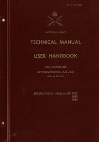 National Vietnam Veterans Museum (NVVM)
Booklet, Australian Army, Australian Army: Technical Manual, User Handbook: Tent, Extendable Accommodation, 14ft x 14ft. (8340-66-037-1659), 1972
A burgandy plastic cover with gold information on the front. Top right hand corner reads 7610-66-037-3220. Under the Australian Army insignia is the details of the booklet. There are two punch holes down the left hand side of t he booklet. The booklet is loose and stored on a plastic cover.australia - armed forces - service manuals, user handbook, tent, accommodation -
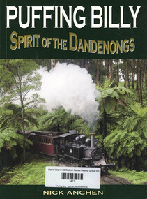 Narre Warren and District Family History Group
Book, Nick Anchen, Puffing Billy : spirit of the Dandenongs, 2017
The Puffing Billy Railway is a genuine living museum, part of the original Victorian Railways branch line which operated for fifty three years between Upper Ferntree Gully and Gembrook. The quaint little train became in institution of the Dandenongs, and the closure of the line in 1954 caused a public outcry. The salvation and continuing operation of Australia’s best-loved steam train is one of the great Australian stories. The history, preservation and current operation of the Puffing Billy Railway. A detailed description of the Puffing Billy train journey, including information on local history, fauna and flora. Technical details of locomotives, rolling stock and other associated equipment. An extensive photographic gallery featuring over 200 b&w and colour images.108 p.; 24 cmnon-fictionThe Puffing Billy Railway is a genuine living museum, part of the original Victorian Railways branch line which operated for fifty three years between Upper Ferntree Gully and Gembrook. The quaint little train became in institution of the Dandenongs, and the closure of the line in 1954 caused a public outcry. The salvation and continuing operation of Australia’s best-loved steam train is one of the great Australian stories. The history, preservation and current operation of the Puffing Billy Railway. A detailed description of the Puffing Billy train journey, including information on local history, fauna and flora. Technical details of locomotives, rolling stock and other associated equipment. An extensive photographic gallery featuring over 200 b&w and colour images. puffing billy railway, dandenongs -
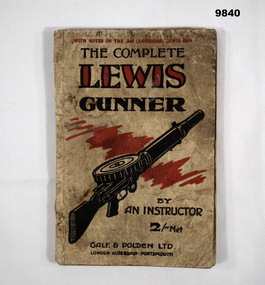 Bendigo Military Museum
Manual - THE COMPLETE LEWIS GUNNER, Gale & Polden Limited, c.WW1
From front cover; "WITH NOTES ON THE .300 (AMERICAN) LEWIS GUN/ THE COMPLETE LEWIS GUNNER/ BY AN INSTRUCTOR". Part of the William (Bill) THOMASON Collection. Refer Cat. No. 4136P for more items.Soft cover book. Cover - beige colour cardboard, with black and red ink print on front and back. Illustrated front - sketch of a Lewis gun. 76 pages - cut, plain, white paper. Illustrated black and white photographs and technical diagrams. End paper - with black ink print information. Front end paper - "FOREWORD BY THE AUTHOR" - handwritten information.Handwritten information - blue ink pen. "?? K. ARNELL".publications, books, instruction manual, lewis gun, william (bill) thomason collection -
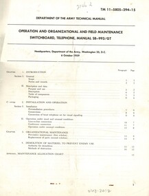 National Vietnam Veterans Museum (NVVM)
Manual, United States Army, Department of the Army Technical Manual: Operation And Organizational And Field Maintenance Switchboard, Telephone, Manual SB-993/GT, 1961
A cream coloured paper cover with black information on the front. In bold ink at the top reads TM 11-5805-294-15. There are lots of detail on the cover.operator's manual, united states war office, technical manual, field maintenance, switchboard telephone, manual sb-993-gt -
 National Vietnam Veterans Museum (NVVM)
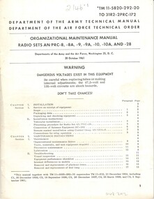
Manual, United States Army, Department of the Army Technical Manual: Organizational Maintnance Manual: Radio sets AN/PRC-8, -8A, -9, -9A, -10,-10A AND -28, 1961
A cream coloured paper cover with black information on the front. In bold ink at the top reads TM 11-5820-292-20. There are lots of detail on the cover.operator's manual, radio sets, radio set an/prc - 8, united states war office