Showing 1123 items matching " waterways"
-
 Lakes Entrance Historical Society
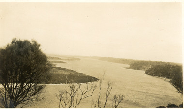
Postcard - The Narrows, 1930c
... Waterways ...Black and white small format postcard of a steamer in the Narrows, Rigby Island opposite the steep shoreline of the mainland, Reeve's Channel, Fraser Island and Flannagan Island in distance, Gippsland Lakes, Lakes Entrance Victoria.islands, waterways, topography -
 Lakes Entrance Historical Society
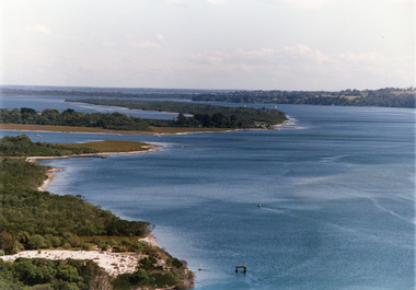
Photograph - Lake King, Tambo Shire, 1995c
... Waterways ...Also second copyColour photograph of portion of Rigby Island, Fraser Island, and Flannagan Island, and Reeves Channel of Lake King, Gippsland Lakes. Steep shore of mainland in distance. Lakes Entrance Victoriaislands, waterways, topography -
 Lakes Entrance Historical Society
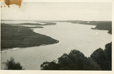
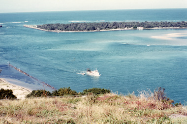
Photograph - Lake King, 1950c
... Waterways ...Also copy of same view, stained, 9 x 14Black and white photograph of the Narrows and Reeves Channel of Lake King, Gippsland Lakes. It shows Rigby, Fraser, and Flannagan Islands opposite the steep shoreline of the mainland. Taken from Jemmy's Point, it shows a recently built groyne from Rigby Island into the Narrows. Lakes Entrance Victoriaislands, waterways, topography -
 Lakes Entrance Historical Society
Photograph - Reeves Channel, 1930c
... Waterways ...Black and white photograph of Reeves Channel on Lake King, Gippsland Lakes. It shows part of Rigby Island opposite the steep mainland shore of the lake. Lakes Entrance Victoriaislands, waterways, topography -
 Lakes Entrance Historical Society
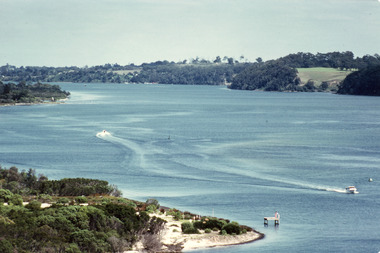
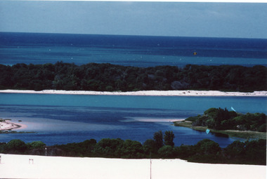
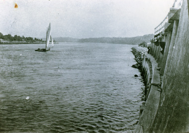
Photograph - Reeves Channel, Fraser, Ian, 1995c
... Waterways ...Colour photograph of Reeves Channel of Lake King, Gippsland Lakes. It shows part of both Rigby Island and Fraser Island opposite the steep shoreline of the mainland. Two motor boats on lake. Lakes Entrance Victoriaislands, waterways, topography -
 Lakes Entrance Historical Society
Photograph - The Entrance, Fraser, Ian, 1990c
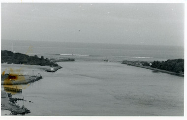
... Waterways ...Colour photograph of the lake. It shows a fishing boat with scallop dredge moving up the lake opposite the artificial entrance, grassy edge of Jemmy's Point in foreground above highway guard fence, rock groyne at entry to North Arm, sandy shallows at entry to Hopetoun Channel, scrub covered hummocks of south shore and Bass Strait in distance. Lakes Entrance Victoriaislands, waterways, topography -
 Lakes Entrance Historical Society
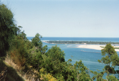
Photograph - Hopetoun Channel, Fraser, Ian, 1996c
... Waterways ...Colour photograph of Bass Strait, scrub covered coastal dunes, Hopetoun Channel, and southern portion of Rigby Island. Photo taken from sand dunes on Flannagan Island, near Lakes Entrance, Victoria.islands, waterways, topography -
 Lakes Entrance Historical Society
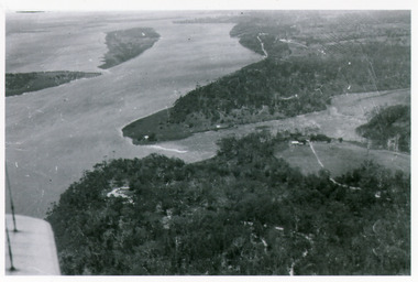
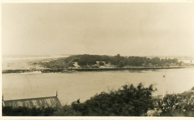
Photograph - Kalimna, Bulmer H D, 1940c
... Waterways ...Black and white photograph of view over Kalimna, Maringa Creek, Saw Mill Flat, Fraser Island, Flannagan Island, aireal view. Lakes Entrance, Victoria.waterways, topography, townships -
 Lakes Entrance Historical Society
Photograph - The Entrance, 1992c
... Waterways ...Colour photograph of the western side of the Entrance. It shows scrub covered hummocks, dredged sand dumped at Snake Island, rock groynes from island to lake, taken from lower side of highway at Jemmys Point. Lakes Entrance Victoriaislands, topography, waterways -
 Lakes Entrance Historical Society
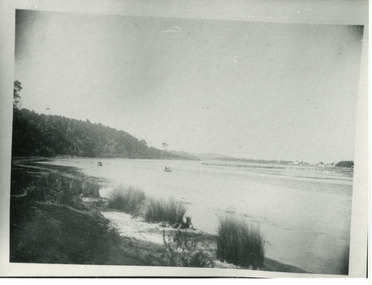
Photograph - North Arm, Phillips, Miss L, 1910c
... Waterways ...Black and white photograph of North Arm. It shows the reedy shoreline in foreground, jetty to island in lake, two small boats on water, distant view of township. Lakes Entrance Victoriawaterways, topography, vegetation -
 Lakes Entrance Historical Society
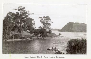
Photograph - North Arm, 1920c
... Waterways ...Copy same view but titled 'North Arm - Lakes Entrance' 11.5 x 18Black and white photograph of the North Arm. It shows the calm waters of the arm which twist and turn between high scrub covered banks. Distant view of township, two people in small boat in foreground. Lakes Entrance VictoriaLakes Scene North Arm Lakes Entrancevegetation, topography, waterways -
 Lakes Entrance Historical Society
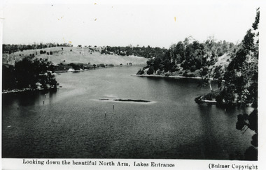
Photograph - North Arm, Bulmer H D, 1930c
... Waterways ...Black and white photograph of the North Arm, showing the calm waters between steep banks covered in natural vegetation, but for one hillside which has been almost completely cleared, a few ring barked trees still standing. Lakes Entrance VictoriaLooking down the beautiful North Arm Lakes Entrancevegetation, waterways, topography -
 Lakes Entrance Historical Society
Photograph - Wombat, 1890c
... Waterways ...1 other photograph 10 x 16 archived.Black and white photograph showing view of entrance, dunes and Bullock Island, buildings and dunes at left, building and jetty and rock groynes on Bullock Island. Vessel near centre may be the Carpenter owned dredge the Wombat. Lakes Entrance Victoria jetties, dredges, waterways -
 Lakes Entrance Historical Society
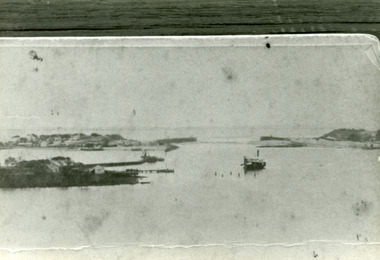
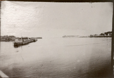
Photograph - The Entrance, 1890c
... Waterways ...One other copy same sizeBlack and white photograph of newly opened entrance to Gippsland Lakes from Bass Strait, Lakes Entrance, Victoria.boats and boating, waterways, piers -
 Lakes Entrance Historical Society
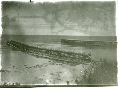
Photograph - Entrance Piers, 1905c
... Waterways ...Black and white photograph showing piers and entrance to Gippsland Lakes from ocean Bass Strait. Few people on boardwalk on piers. Lakes Entrance Victoriaboardwalk, waterways, piers -
 Lakes Entrance Historical Society
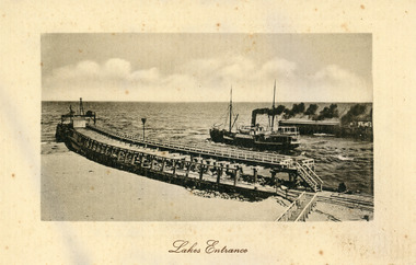
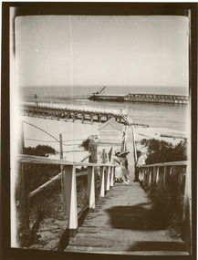
Postcard - S.S. Wyralla, 1920c
... Waterways ...Postcard printed in Germany has serrated edging. Also another sepia toned copy 10 x 15cm.Black and white postcard showing SS Wyralla steaming out entrance into Bass Strait, lot of smoke. Workshed on end of eastern pier. No-one on piers or beach on left of eastern pier. Boardwalk on right on end of pier. Tramline visible. waterways, piers, ships and shipping -
 Lakes Entrance Historical Society
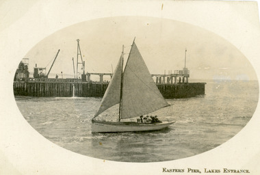
Postcard - Eastern Pier, 1910c
... Waterways ...Second copy same imageSepia postcard in cameo image, showing small sailing boat in entrance to the Gippsland Lakes, at Lakes Entrance, Victoria, with wooden eastern pier behind machinery on pier, travelling steam crane on left, 6 - 7 people in boat.Eastern Pier Lakes Entrance waterways, piers, boats and boating -
 Lakes Entrance Historical Society
Photograph - The Entrance, 1920c
... Waterways ...Black and white photograph showing entrance to Gippsland Lakes from ocean Bass Strait. People in 1920s style dress on boardwalk. Kiosk on beach closed. Vegetation either side of boardwalk. Lakes Entrance Victoria waterways, piers, kiosk -
 Lakes Entrance Historical Society
Photograph - The Entrance, 1910c
... Waterways ...also copies|Two black and white 8.5 x 14|Two black and white 16 x 25Sepia photograph showing view of entrance to Gippsland Lakes from ocean- Bass Strait, looking west towards Western Pier and dunes. Foreground on left shows gable roof of rocket shed and shipwreck bell on white post on right. Lakes Entrance Victoriawaterways, sandbar, rocket shed -
 Lakes Entrance Historical Society
Photograph - The Entrance, 1922
... Waterways ...Black and white photograph showing entrance and piers, viewed from ocean end of pier looking north towards Kalimna, small sailing boat in entrance inside of Eastern Pier, on right amongst the timber piers is a man leaning out. Lakes Entrance Victoria waterways, piers, boats and boating -
 Lakes Entrance Historical Society
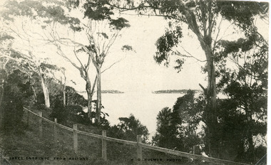
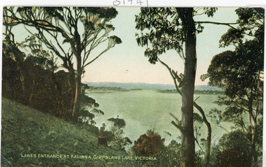
Postcard - The Entrance, Bulmer H D, 1910c
... Waterways ...Black and white postcard of the man made entrance through the hummocks, taken from the cliff top at Kalimna. Shows an indistinct distant view of the entrance, natural vegetation in foreground behind simple timber and chicken wire boundary fence. Lakes Entrance VictoriaLakes Entrance from Kalimnawaterways, topography, islands -
 Lakes Entrance Historical Society
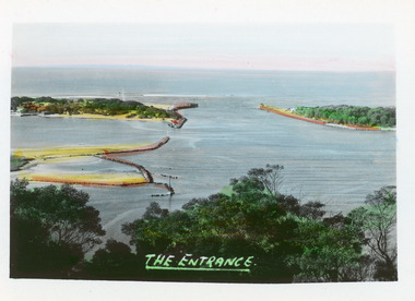
Postcard - The Entrance, 1910c
... Waterways ...Colour tinted postcard of the man made entrance to the Gippsland Lakes. It shows the entrance and groynes at Bullock Island, natural vegetation on cliff top in foreground. Lakes Entrance VictoriaLakes Entrance at Kalimna, Gippsland Lakes Victoriavegetation, waterways, topography -
 Lakes Entrance Historical Society
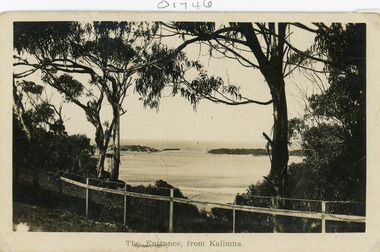
Postcard - The Entrance
... Waterways ...Black and white postcard of the man made entrance through the sand hummocks, taken from Kalimna cliff top. In the foreground native vegetation on the cliff top behind simple timber and wire netting boundary fence topped with a single strand of barbed wire. Lakes Entrance VictoriaThe Entrance from Kalimnawaterways, topography, islands -
 Lakes Entrance Historical Society
Postcard - The Entrance, 1940c
... Waterways ...2 x identical mini postcards collected 6.5 x 9|1 x photographic print copy 18.5 x 25Black and white small format postcard of the man-made entrance from Bass Strait to the Gippsland Lakes, taken from Jemmys Point. It shows the rock groynes at Bullock Island and North Arm entrance. Lakes Entrance Victoriaislands, waterways, topography -
 Lakes Entrance Historical Society
Postcard - The Entrance, Bulmer H D, 1940c
... Waterways ...Hand tinted small format postcard of the entrance to the Gippsland Lakes, taken from Jemmys Point. It shows the rock groynes at Bullock Island with dredged sand filling the basin between island and groyne. Lakes Entrance VictoriaThe Entranceislands, waterways, topography -
 Lakes Entrance Historical Society
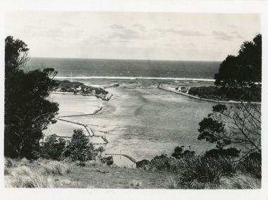
Photograph - The Entrance, 1986
... Waterways ...Black and white photograph of the entrance from Bass Strait to the Gippsland Lakes. It also shows the rock groynes at Bullock Island filled with dredged sand to extend the island. Fishing boat coming through entrance. Lakes Entrance Victoriaislands, topography, waterways -
 Lakes Entrance Historical Society
Photograph - Tramline, Fish Marie, 1997
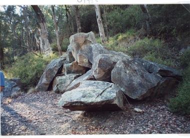
... Waterways ...Date made 18 January 1997Colour photograph of a pile of granite rock left on the bank of the North Arm. This rock was quarried at Mississippi Creek and conveyed by tramline to the North Arm where it was loaded on barges and conveyed to the entrance where it was used to stabilise the piers. Lakes Entrance Victoria waterways, public works, quarries -
 Lakes Entrance Historical Society
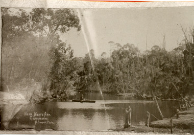
Photograph - North Arm, Cooper Alexander, 1910c
... Waterways ...Copied from original by Merle DerbyshireBlack and white photograph of a section of the North Arm. It shows a person in a small boat on the calm waters, dense natural vegetation on each side of lake. Lakes Entrance VictoriaHead, North Arm, Cunninghame waterways, topography, recreation -
 Lakes Entrance Historical Society
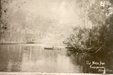
Photograph - North Arm, Cooper Alexander, 1910c
... Waterways ...Copied from original by Merle DerbyshireBlack and white photograph of a calm reach of the North Arm. It shows dense vegetation on both sides of the water, person sitting in small boat on lake. Lakes Entrance VictoriaUp North Arm, Cunninghame waterways, topography, recreation -
 Lakes Entrance Historical Society
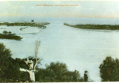
Postcard - The Entrance, 1900c
... Waterways ...Also copy tinted postcard 10 x 15Coloured post card of the man made entrance through the sand dunes, taken from Jemmys Point. It shows the works and settlement at the entrance, Bullock Island and groynes to direct flow of lake waters towards entrance. Two men standing on Jemmys Point. Lakes Entrance VictoriaLakes Entrance, Cunninghame, Victoriaislands, waterways, topography