Showing 1369 items
matching 1786-1875. | explorers -- australia -- biography. | australia -- discovery and exploration.
-
 Bendigo Historical Society Inc.
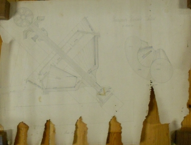
Plan - MARKS COLLECTION: HARRISON'S QUARTZ PULVERISER PLAN
Sepia coloured heavy paper, plans drawn in black pen. Written on top of plan: Youngman Harrison's Patent, 22 March 1875' Plans contain drawings labelled as copper pages, roller, grating, drag. Plan has been tightly rolled. On outer edge, written in black pen Harrison Quartz Tailings Pulveriser (last word unclear)equipment, quartz tailing pulverisor, gold mining, lansell -
 University of Melbourne, Burnley Campus Archives
Plan - Photocopy, 1. [Botanic Gardens] upon the retirement of Baron Von Mueller from the Directorship, 1873. 2. Botanic Gardens, 1909, showing alterations and additions effected since 1873. By W.R. Guilfoyle. Director, c.1873-1909
Photocopies. (1) 2 copies, "[Botanic Gardens] upon the Retirement of Baron von Mueller from the Directorship, 1873." Source unknown, addition of 30 acres in 1875 noted. (2) 2 copies, "Botanic Gardens, 1909, showing alterations and additions effected since 1873 by W. R. Guilfoyle, Director." Source unknown. Shows grid lines.ferdinand von mueller, w.r. guilfoyle -
 Ballarat Heritage Services
digital copy, Death Certificate Julien Hardy
Death certificate of Julien Hardy, mason, who died May 1875 at Warrenheip, aged 44 years. Father Julien Hardy, and mother Jane Mary (Jean Marie) Penton.death, certificate, julien hardy, hardy, stonemason, warrenheip -
Clunes Museum
Document - EXTRACTS
DATES OF IMPORTANCE; NORTH CLUNES STATE SCHOOL OPENED 2. JULY 1875. RAILWAY TO CLUNES OPENED 16/10/1874, WATER WORKS PURCHASED 10/2/1874CREAM COVER, WIRE BOUND STUDENT'S EXERCISE BOOK.CONTAINING EXTRACTS FROM VARIOUS SOURCES 1869. FROM GOLDFIELDS AND MINERAL DISTRICTS OF VICTORIA BY R. BROUGH SMYTH 1869local history, document, local government, shire, mining -
 Linton and District Historical Society Inc
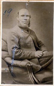
Photograph, John Robertson Snr
Father of John Robertson (Jnr.), who was one of the first teachers at Linton State School. Died 1875 and is buried in Linton cemetery. Photograph is part of Old Lintonian collection ; No. 19.Portrait of an seated gentleman wearing suit, with right arm folded across front.old lintonian collection, john robertson snr. -
 Eltham District Historical Society Inc
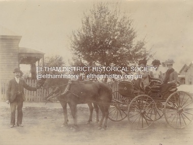
Photograph, Chris Watson with Carrie Shillinglaw holding baby Jean and her sisters Elizabeth and Mary Shillinglaw in the back of the carriage, c.1906
The baby is most probably Jean Watson, daughter of Chris and Carrie who was born in 1906. Christoher Watson and Carolyn Shillinglaw married in 1907. Jean died in 1920 PANEL 1875-1920 Panels began to be produced around 1875, and were particularly suited, because of their larger size, for capturing family, or even larger, groups. They measured 8.5 by 6.5 inches (22 cm x 16.5 cm). - Frost, Lenore; Dating Family Photos 1850-1920; Valiant Press Pty. Ltd., Berwick, Victoria 1991In had written pencil "C. Watson Carrie Watson her sisters Elizabeth and Mary Shillinglaw"marg ball collection, 1906, caroline (carrie) watson (nee shillinglaw 1876-1956), christopher watson, elizabeth (lizzie) ann shillinglaw (1879-1972), horse and carriage, jean watson (1906-1920), mary ann shillinglaw (1880-1963) -
 Learmonth and District Historical Society Inc.
Photo -Rennie, Richards & Co. Photos Ballaarat, President George Rennie,Esq, "Circa1886"
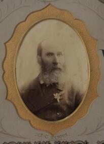
Councilor George Rennie was elected as a member of council in 1875 until1890.He was appointed for two terms as President ,1885-86 and 1886-87.He died in1898 aged 74 years.Original Historict Photo.Sepia photo of President George Rennie Esq.(Oval) is in the middle of collection of photos of all councilors for 1885-86.It is surrounded by a shaped gold border Presented by the President G.Rennie Esq. to the Ballarat Shire Council 1885-86.ballarat shire council, president 1885 1886, rennie george esq -
Bendigo Historical Society Inc.
Document - Presentation, abt1998
Strathfieldsaye State School (SS 1211) began in the Shire Hall in March 1873. Five acres was gazetted in January 1874 and a three roomed, weatherboard school building opened in January 1875.Photo copied hand written notes on the history of the Strathfieldsaye Primary School - "Back To Celebrations" A typed A4 sheet outlining the history and also a photo of the school. Notes from a presentation by Mr Alf Ryall.history, bendigo, strathfieldaye primary school, alf ryall -
Bendigo Historical Society Inc.
Programme - 125th Anniversary, March 1998
Strathfieldsaye State School (SS 1211) began in the Shire Hall in March 1873. Five acres was gazetted in January 1874 and a three roomed, weatherboard school building opened in January 1875.Stathfieldsaye Primary School 125th Anniversary programme and tour guide. 1873 to 1998. The six pages includes a song called Pathways to the future by Gail Godber; a programme; history of the school and a plan of the school.history, bendigo, strathfieldaye primary school, back to celebrations 125th anniversary, gail godber -
 City of Ballarat Libraries
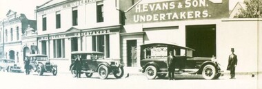
Photograph - Card Box Photographs, H. Evans & Sons Undertakers, Ballarat circa 1931
Henry Evans can be seen wearing the top hat. The building on Main Road was originally the London Chartered Bank built in circa 1875. The original facade is believed to be behind new brickwork.henry evans, undertakers, main road, london chartered bank, ballarat, vehicles, funeral, building, h. evans & son -
 The Beechworth Burke Museum
Photograph
Taken on 25 October 1930, various houses with the Hume Dam under construction are depicted in the background. The construction of the Hume Dam took place from 1919 to 1936. At the time of construction, it was the second largest dam in the world. It was also one of the earliest civil projects developed after the Federation. Some of the Dam workers consisted of World War I veterans. Dam workers often settled their families in Mitta Junction Village and Wodonga. Archaeological surveys were completed by Austral Archaeology, which was done when the Department of Land & Water Conservation was doing work to improve Hume Dam. The archaeological report that came out of the survey recommended three sites of interest where archaeological excavation should be done: Camp Ganger’s Quarters, Stableman’s Quarters, and the Industrial Dump. The excavation uncovered artefacts. Mitta Mitta: Mitta Mitta is situated between Mount Welcome and Mount Misery. It is named after the river that explorers Hume and Hovell discovered in 1824. The town would eventually become a huge gold mining town. Mitta Mitta is called Midamodunga by the local Indigenous peoples Wodonga: Wodonga is situated on the Murray River and is part of North East Victoria. Hume and Hovell: Hamilton Hume (1979-1873) and William Hilton Hovell (1786-1875). W. H. Hovell was born in Norfolk England and Hume was born in Parramatta, New South Wales Hovell and Hume undertook an exploration journey in 1824 and thought they discovered a river, which turned out to be the Murray River. They returned home in 1825, but returned to the area in 1826 and discovered coal in the area. This photo is historically significant as it shows the Hume Dam under construction in 1930. The Dam was named after Hamilton Hume, who is an important historical figure for this area as he helped discover the area where resources were found.Sepia rectangular photograph printed unmountedReverse: 84-19-5 / 1997.3185/ Values & spillway. / When completed the wall / will be as high as the / scaffolding. [featuring trademark: kodak print]construction, houses, veterans, mitta junction village, hume dam, world war i, federation, wodonga, archaeological survey, excavation, austral archaeology, department of land & water conservation, camp ganger's quarter's, stableman's quarters, industrial dump, artefacts, mitta mitta, mount welcome, mount misery, murray river, hamilton hume, william hilton hovell, hume and hovell expedition -
 The Beechworth Burke Museum
Photograph, c1930
Taken on 25 October 1930, various houses with the Hume Dam under construction are depicted in the background. The construction of the Hume Dam took place from 1919 to 1936. At the time of construction, it was the second largest dam in the world. It was also one of the earliest civil projects developed after the Federation. Some of the Dam workers consisted of World War I veterans. Dam workers often settled their families in Mitta Junction Village and Wodonga. Archaeological surveys were completed by Austral Archaeology, which was done when the Department of Land & Water Conservation was doing work to improve Hume Dam. The archaeological report that came out of the survey recommended three sites of interest where archaeological excavation should be done: Camp Ganger’s Quarters, Stableman’s Quarters, and the Industrial Dump. The excavation uncovered artefacts. Mitta Mitta: Mitta Mitta is situated between Mount Welcome and Mount Misery. It is named after the river that explorers Hume and Hovell discovered in 1824. The town would eventually become a huge gold mining town. Mitta Mitta is called Midamodunga by the local Indigenous peoples Wodonga: Wodonga is situated on the Murray River and is part of North East Victoria. Hume and Hovell: Hamilton Hume (1979-1873) and William Hilton Hovell (1786-1875). W. H. Hovell was born in Norfolk England and Hume was born in Parramatta, New South Wales Hovell and Hume undertook an exploration journey in 1824 and thought they discovered a river, which turned out to be the Murray River. They returned home in 1825, but returned to the area in 1826 and discovered coal in the area.This photo is historically significant as it shows the Hume Dam under construction in 1930. The Dam was named after Hamilton Hume, who is an important historical figure for this area as he helped discover the area where resources were found.Sepia rectangular photograph printed unmountedReverse: 84-19-2/ 1997.3188/ These are the four / release valves they are / not always open (illegible) this / when closed the water flows / over the spillway. [featuring trademark: kodak print] photograph number: 354construction, houses, veterans, mitta junction village, hume dam, world war i, federation, wodonga, archaeological survey, excavation, austral archaeology, department of land & water conservation, camp ganger's quarter's, stableman's quarters, industrial dump, artefacts, mitta mitta, mount welcome, mount misery, murray river, hamilton hume, william hilton hovell, hume and hovell expedition -
 The Beechworth Burke Museum
Photograph, 25 October 1930
Taken on 25 October 1930, various houses with the Hume Dam under construction are depicted in the background. The construction of the Hume Dam took place from 1919 to 1936. At the time of construction, it was the second largest dam in the world. It was also one of the earliest civil projects developed after the Federation. Some of the Dam workers consisted of World War I veterans. Dam workers often settled their families in Mitta Junction Village and Wodonga. Archaeological surveys were completed by Austral Archaeology, which was done when the Department of Land & Water Conservation was doing work to improve Hume Dam. The archaeological report that came out of the survey recommended three sites of interest where archaeological excavation should be done: Camp Ganger’s Quarters, Stableman’s Quarters, and the Industrial Dump. The excavation uncovered artefacts. Mitta Mitta: Mitta Mitta is situated between Mount Welcome and Mount Misery. It is named after the river that explorers Hume and Hovell discovered in 1824. The town would eventually become a huge gold mining town. Mitta Mitta is called Midamodunga by the local Indigenous peoples Wodonga: Wodonga is situated on the Murray River and is part of North East Victoria. Hume and Hovell: Hamilton Hume (1979-1873) and William Hilton Hovell (1786-1875). W. H. Hovell was born in Norfolk England and Hume was born in Parramatta, New South Wales Hovell and Hume undertook an exploration journey in 1824 and thought they discovered a river, which turned out to be the Murray River. They returned home in 1825, but returned to the area in 1826 and discovered coal in the area.This photo is historically significant as it shows the Hume Dam under construction in 1930. The Dam was named after Hamilton Hume, who is an important historical figure for this area as he helped discover the area where resources were found.Sepia rectangular photograph printed unmountedReverse: 84-19-6/ 1997.3187/ The spillway [featuring trademark: kodak print] construction, houses, veterans, mitta junction village, hume dam, world war i, federation, wodonga, archaeological survey, excavation, austral archaeology, department of land & water conservation, camp ganger's quarter's, stableman's quarters, industrial dump, artefacts, mitta mitta, mount welcome, mount misery, murray river, hamilton hume, william hilton hovell, hume and hovell expedition -
 The Beechworth Burke Museum
Photograph, 25 October 1930
Taken on 25 October 1930, various houses with the Hume Dam under construction are depicted in the background. The construction of the Hume Dam took place from 1919 to 1936. At the time of construction, it was the second largest dam in the world. It was also one of the earliest civil projects developed after the Federation. Some of the Dam workers consisted of World War I veterans. Dam workers often settled their families in Mitta Junction Village and Wodonga. Archaeological surveys were completed by Austral Archaeology, which was done when the Department of Land & Water Conservation was doing work to improve Hume Dam. The archaeological report that came out of the survey recommended three sites of interest where archaeological excavation should be done: Camp Ganger’s Quarters, Stableman’s Quarters, and the Industrial Dump. The excavation uncovered artefacts. Mitta Mitta: Mitta Mitta is situated between Mount Welcome and Mount Misery. It is named after the river that explorers Hume and Hovell discovered in 1824. The town would eventually become a huge gold mining town. Mitta Mitta is called Midamodunga by the local Indigenous peoples Wodonga: Wodonga is situated on the Murray River and is part of North East Victoria. Hume and Hovell: Hamilton Hume (1979-1873) and William Hilton Hovell (1786-1875). W. H. Hovell was born in Norfolk England and Hume was born in Parramatta, New South Wales Hovell and Hume undertook an exploration journey in 1824 and thought they discovered a river, which turned out to be the Murray River. They returned home in 1825, but returned to the area in 1826 and discovered coal in the area.This photo is historically significant as it shows the Hume Dam under construction in 1930. The Dam was named after Hamilton Hume, who is an important historical figure for this area as he helped discover the area where resources were found.Black and white rectangular photograph printer unmountedReverse: 84-20-1/ 1997.3147construction, houses, veterans, mitta junction village, hume dam, world war i, federation, wodonga, archaeological survey, excavation, austral archaeology, department of land & water conservation, camp ganger's quarter's, stableman's quarters, industrial dump, artefacts, mitta mitta, mount welcome, mount misery, murray river, hamilton hume, william hilton hovell, hume and hovell expedition -
 The Beechworth Burke Museum
Photograph, 25 October 1930
Taken on 25 October 1930, various houses with the Hume Dam under construction are depicted in the background. The construction of the Hume Dam took place from 1919 to 1936. At the time of construction, it was the second largest dam in the world. It was also one of the earliest civil projects developed after the Federation. Some of the Dam workers consisted of World War I veterans. Dam workers often settled their families in Mitta Junction Village and Wodonga. Archaeological surveys were completed by Austral Archaeology, which was done when the Department of Land & Water Conservation was doing work to improve Hume Dam. The archaeological report that came out of the survey recommended three sites of interest where archaeological excavation should be done: Camp Ganger’s Quarters, Stableman’s Quarters, and the Industrial Dump. The excavation uncovered artefacts. Mitta Mitta: Mitta Mitta is situated between Mount Welcome and Mount Misery. It is named after the river that explorers Hume and Hovell discovered in 1824. The town would eventually become a huge gold mining town. Mitta Mitta is called Midamodunga by the local Indigenous peoples Wodonga: Wodonga is situated on the Murray River and is part of North East Victoria. Hume and Hovell: Hamilton Hume (1979-1873) and William Hilton Hovell (1786-1875). W. H. Hovell was born in Norfolk England and Hume was born in Parramatta, New South Wales Hovell and Hume undertook an exploration journey in 1824 and thought they discovered a river, which turned out to be the Murray River. They returned home in 1825, but returned to the area in 1826 and discovered coal in the area. This photo is historically significant as it shows the Hume Dam under construction in 1930. The Dam was named after Hamilton Hume, who is an important historical figure for this area as he helped discover the area where resources were found. Black and white rectangular photograph printer unmountedReverse: 1997.3145/ 84-20-2construction, houses, veterans, mitta junction village, hume dam, world war i, federation, wodonga, archaeological survey, excavation, austral archaeology, department of land & water conservation, camp ganger's quarter's, stableman's quarters, industrial dump, artefacts, mitta mitta, mount welcome, mount misery, murray river, hamilton hume, william hilton hovell, hume and hovell expedition -
 Clunes Museum
Photograph
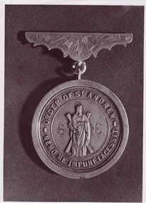
MASONIC JEWELL PRESENTED TO PAST MASTER OF LODGE OF THE GOLDEN FLEECE..1 & .2 BLACK AND WHITE PHOTOGRAPHS OF MASONIC JEWEL (OBVERSE AND REVERSE) .3 LETTER OF VERIFICATION FROM DONOR (UNDATED BUT RECIEVED AT THE MUSEUM ABOUT JUNE 1974)ON OBVERSE: ORDER OF ST. ANDREW NEMO ME IMPUNE LACESSIT ON REVERSE: ENGRAVED: "PRESENTED TO BRO. JOHN LATIMER WORSHIPFUL MASTER CLUNES LODGE O.S.A, S.C BY HIS BRETHREN 20 JANUARY 1875" "WE ARE BRITHERS AYE FOR A'THAT"local history, photography, photographs, lodge - freemason -
Bendigo Historical Society Inc.
Document - Johnny Greenfield Gill, abt 1900-2010
John Greenfield Gill (1875 - 29/6/1927) married Alberta Jennings Marshall in 1898. He was the mining manager of the Unity Mine in Long Gully and was President of the Mine Manager Association in 1918.Diary of a New Chum, Johnny Greenfield Gill. Contains eight photocopies (B and W) describing his journey to Australia from Wales, Aged 19 years in 1892; also a copy of his ticket on the "Orient" steam ship.history, bendigo, johnny greenfield gill, orient line -
 Bendigo Historical Society Inc.
Newspaper - JENNY FOLEY COLLECTION: SCHOOL PHOTO
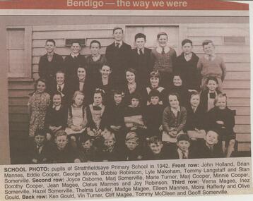
Strathfieldsaye state School (SS1211) began in March 1873 in the Shire Hall. Five acres were gazetted for a school in January 1874 and a 3 roomed weatherboard school was built and opened in January 1875.Bendigo Advertiser ''the way we were'' from 2002. School photo: pupils of Strathfieldsaye Primary school in 1942. Front row: John Holland, Brian Mannes, Eddie Cooper, George Morris, Bobbie Robinson, Lyle Makeham, Tommy Langstaff and Stan Somerville. Second row: Joyce Osborne, Marj Somerville, Marie Turner, Marj Cooper, Minnie Cooper, Dorothy Cooper, Jean Magee, Cletus Mannes and Joy Robinson. Third row: Verna Magee, Inez Somerville, Hazel Somerville, Thelma Loader, Madge Magee, Eileen Mannes, Moira Rafferty and Olive Gould. Back row: Ken Gould, Vin Turner, Cliff Magee, Tommy McCleen and Geoff Somerville. The clip is in a folder.newspaper, bendigo advertiser, the way we were -
Bendigo Historical Society Inc.
Document - Strathfieldsaye Primary School, 1998
Strathfieldsaye state School (SS1211) began in March 1873 in the Shire Hall. Five acres were gazetted for a school in January 1874 and a 3 roomed weatherboard school was built and opened in January 1875.Photo copied notes on the history of the Strathfieldsaye Primary School - "Back To Celebrations" A typed A4 sheet outling the history and also a photo of the school.history, bendigo, strathfieldaye primary school -
Bendigo Historical Society Inc.
Document - MINER'S RIGHT - WILLIAM HALL MINER'S RIGHT
Three pale blue tinted miner's rights, dated 19th June 1873 (No 27311), 4th December 1875 (No 85752) and 10th February 1877 (No 10475) in the name of William Hall. Across the top is a crest with a lion and a unicorn holding up an oval piece with a crown and a lion on top, In the oval is an illustration with two men and a woman and sailing ships in the background. They cost five shillings.document, gold, miner's right, miner's right, william hall, john ferres, george skinner -
 Eltham District Historical Society Inc
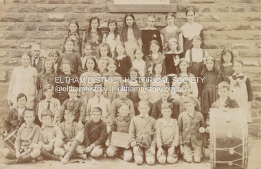
Photograph, Grade 5, Eltham State School No. 209, c.1919
Photo: W. Edmends, 168 Donald St., Brunswick Written on the back in ink "Ernest Bunker" and also noted in pencil (H. Gilham hand?) "Fred Dudfield Head Teacher" PANEL 1875-1920 Panels began to be produced around 1875, and were particularly suited, because of their larger size, for capturing family, or even larger, groups. They measured 8.5 by 6.5 inches (22 cm x 16.5 cm). - Frost, Lenore; Dating Family Photos 1850-1920; Valiant Press Pty. Ltd., Berwick, Victoria 1991marg ball collection, shillinglaw family photo album 3, eltham primary school, eltham state school no. 209, class photo, 1919, w. edmends photographer -
 Eltham District Historical Society Inc
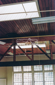
Photograph, Harry Gilham, Renovations to Eltham State School No. 209, Dalton Street, Eltham, 1994
Looking to the south windows of the 1921 extension - skylights were put in in the same time as the 1875 set. The heavy beam across the room carried the weight of the folding door track The bottom guide is in another photo).Handwritten (HG's) information and details in blue ink on reverse sidedalton street, eltham primary school, renovations, building construction, buildings, eltham state school no. 209 -
Linton Mechanics Institute and Free Library Collection
Book - Novel, Patriarche, Valance et al, Rory of Willow Beach, [1912]
196 p. : four illustrations by H. M. Brock; frontispiece illustration, showing a man and a woman who is carrying or wearing an enormous spray of flowers, is reproduced on front cover. Title page missing, information for catalogue record from online sources.fictionfiction, valance patriarche -
 Numurkah & District Historical Society
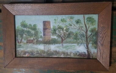
Oil painting Numurkah Water Tower
Painted by Mary Edith (Edie) Thomas pre 1900. Mary was born in 1875 and died in the 1940's. The painting remined in her family home "Lanithe", Naring until about 2010, home of Charlie thomasOil Painting of the Numurkah Water Tower and original Wesleyan Church from east of the Broken Creekoil painting, water tower, mary edith thomas, naring -
 Bendigo Historical Society Inc.
Pamphlet - Advertising card for Superba Skin Food
The Bendigo based Sander family business Sander and Sons, were producers of eucalyptus oil/extract in the 19th and 20th centuries. Carl Sandner established Sander and Sons Eucalyptus Distillery in 1875. It operated until 1967Advertising card. The top half has a black and white illustration of a young woman peering between curtains. Printed in black and purple "I use Superba Skin Food. That's the secret of my beauty. Have you tried it."advertising, sander, sandner -
 Bendigo Historical Society Inc.
Document - Instructions for Superba Skin Food
The Bendigo based Sander family business Sander and Sons, were producers of eucalyptus oil/extract in the 19th and 20th centuries. Carl Sandner established Sander and Sons Eucalyptus Distillery in 1875. It operated until 1967Instructions included in a box of Superba Skin Food. One page with black printing included claims made after use of product and directions for use. Notes that an application for Registration of the distinctive label was made on January 18 1907. Instructions originally folded tightly to fit inside packaging with tin. Two copies.advertising, sander, sandner -
Bendigo Historical Society Inc.
Document - Advertising Brochure, abt 1926
The Bendigo based Sander family business Sander and Sons, were producers of eucalyptus oil/extract in the 19th and 20th centuries. Carl Sandner established Sander and Sons Eucalyptus Distillery in 1875. It operated until 1967. Sander and Sons Advertising Brochure for the Genuine pure volatile Eucalyptus Extracthistory, bendigo, dr a sander, eucalyptus extract -
Bendigo Historical Society Inc.
Document - Advertising Brochure, abt 1926
The Bendigo based Sandner family business - Sander and Sons, were producers of eucalyptus oil/extract in the 19th and 20th centuries. Carl Sandner established Sandner and Sons Eucalyptus Distillery in 1875. It operated until 1967. Dr A. Sandner and Sons Advertising Brochure for the Genuine pure volatile Eucalyptus Extract. Two copies. Four page brochure with lists of testimonials and recommendations by doctors. Inside there is a list of Complaints that may be treated with Eucalypti Extract and instructions for use.history, bendigo, dr a sander, eucalyptus extract -
 Orbost & District Historical Society
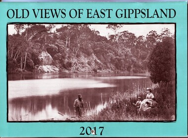
calendar, E-Gee Printers, Old Views of East Gippsland 2017, 2016
This is one of a series of calendars compiled annually by East Gippsland Historical Society.This is a useful pictorial reference tool.A 2017 stapled calendar, titled "Old Views of East Gippsland". On the turquoise coloured front is a black/white photograph of Eagle Point, Mitchell River C 1875 with a family group, possibly Alfred Howitt and children, on the bank of the Mitchell River opposite Eagle Point Bluff.. It contains early photographs of East Gippsland,. There is a hole for hanging. The title is at the top and the year at the bottom in black print. calendar-old-views-of-east-gippsland photographs-historic-east-gippsland -
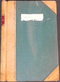 Bendigo Historical Society Inc.
Legal record - Lands Act Application Register
Lands Act Applications Register. farms register for the South Riding of broad undefined extents. Handwritten entries in blue and black ink. Registering Name, Postal address, Parish, Allotment, Section, Area (acres, roods & perches). Dates noted across 17/07/1875 to 31/03/1876. Green lined and formatted legal register with leather/suede spine and cover corners. Handwritten entries in blue and black inkapplication register, farms, south riding