Showing 16557 items
matching 1956-07-26
-
 National Vietnam Veterans Museum (NVVM)
Booklet, Australian Army: Signal training, Vol 2, wireless & Pamphlet No. 2, Aerials, 1956
australia - armed forces - service manuals -
Federation University Historical Collection
Book, Ballarat School of Mines Minute Book, 1956-1961
Federation University Australia was established on 1 January 2014. Formerly known as the University of Ballarat, its enabling legislation was the University of Ballarat Amendment (Federation University Australia) Act 2013. Although formally created as a University in 1994, the University of Ballarat has a lineage back to 1870 with the establishment of the School of Mines Ballarat, making it the third institution of higher learning to be established in Australia and the first to be established in regional Australia. On 1 January 1994, Ballarat University College became the University of Ballarat and in 1998 the University merged with three TAFE Institutes to become a dual sector institution with multiple campuses. On 1 January 2014, the University of Ballarat amalgamated with the Monash University Gippsland Campus to form Federation University Australia. The Gippsland Campus also had a long lineage dating back to 1928 with the establishment of the Yallourn Technical School which became a predecessor institution to the Gippsland College of Advanced Education formed in 1968. In 1990, it was renamed the Monash University College and in 1993 became the Gippsland Campus of Monash University. In 2016, Federation University Australia announced plans to take possession, over a two-year period, of Monash’s Berwick Campus in the south-east corridor of Melbourne. Federation University Australia, or FedUni, is headquartered in Ballarat and offers programs in Higher Education and Vocational Education and Training to regional Victoria and beyond. The University’s commitment to educational and social equity, teaching excellence, research distinction, environmental sustainability and regional capacity building has enabled it to develop in a way that draws on its proud heritage to inform its future. Its regional character sets a framework for the University’s priorities but does not constrain it from serving wider community interests, nationally and internationally. The name Federation University Australia was chosen to convey the scope and capacity of an expanded regional university with a federated network of campuses.Hard Cover book, partly bound in leather with Ballarat School of Mines Council Minutes, and Finance Committee minutes. ballarat school of mines, ballarat school of mines council, ballarat school of mines council minutes, ballarat school of mines finance committee, josephine brelaz schlarship, a.j. affleck, h.l. allnut, arblaster, h.e., aston, robert, barker, k.c., barrell, g.w., beaston, c.w, benney, v, blackwood, r.r., noel brelaz, brelaz guido, brinsden, neville bunning, james caldwell, callow, n.l, clelland, john, corbould, day, p.l., dewsnap, n.f., w.g. durant, elliott, m., faulkner, f, ferguson, f.e., finn, william, gallagher, b., garner, l, gordon, i.r., hancock, v, heseltine, mary, hooper, noel, hullick, k, m.b. john, johnson, alan ernest, johnson, b.a., bullarto, bullarto excursion, ballarat gaol, m.b. john brassworks, motor mechanics huts, 90th anniversary, josephine brelaz, v. hancock, alfred mica smith, john wolfe, s.d. wynes, r.w. richards award, spargo creek, spargo creek excursion -
Moorabbin Air Museum
Book - RAF FLYING REVIEW 1956-57, KEITH ISAACS, 1956
-
 Federation University Art Collection
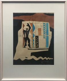
Work on paper - Printmaking - Lithograph (Limited Edition), Le Corbusier, 'Modulor' by Le Corbusier, 1956
Le Corbusier (or Charles-Édouard Jeanneret-Gris) (6 October 6, 1887 – August 27, 1965) Born Chaux-de-Fonds, Switzerland Studied at the local art school Began to study architecture in 1905 With Amedee Ozenfant founded the journal “L’Esprit Nouveau” in 1920 Became a French citizen in 1930 La Corbusier was a Swiss-French architect, designer, painter, urban planner, writer, and one of the pioneers of what is now called modern architecture. He was born in Switzerland and became a French citizen in 1930. His career spanned five decades, with his buildings constructed throughout Europe, India, and the Americas. (Wikipedia) The Modulor is an anthropometric scale of proportions devised by the Swiss-born French architect Le Corbusier (1887–1965). It was developed as a visual bridge between two incompatible scales, the imperial and the metric system. It is based on the height of a man with his arm raised. It was used as a system to set out a number of Le Corbusier's buildings and was later codified into two books. (wikipedia) This item is part of the Federation University Art Collection. The Art Collection features over 1000 works and was listed as a 'Ballarat Treasure' in 2007.Limited edition lithograph after an original collage by Le Corbusier, probably executed in Mourlot Workshop. art, artwork, le corbusier, modular, mourlot workshop, lithograph, colour lithograph, printmaking, aavailable -
 Victorian Railway History Library
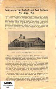
Booklet, South Australian Railways Institute Magazine, Centenary of the Adelaide and Port Railway 21st April 1956, 1956
A history of early broad gauge railway from Adelaide to Port in South Australia to celebrate the centenary in 21-04-56.ill, p.15non-fictionA history of early broad gauge railway from Adelaide to Port in South Australia to celebrate the centenary in 21-04-56.railroad construction - south australia - history, railroad operations - south australia - history -
 Melbourne Tram Museum
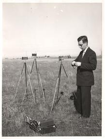
Photograph - Black & White Photograph/s, 4/3/1956
Photograph, Black and White, of Keith Kings 4/3/1956, with his camera equipment, in the Broadmeadows area.In ink on the rear "WJW-368 EV-28, 4/3/1956, KSK North Broadmeadows."trams, tramways, personnel -
 Ballarat Tramway Museum
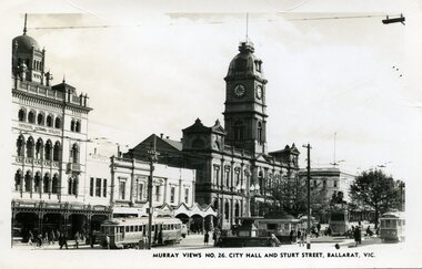
Photograph - Black & White Photograph/s, Murray Views, Murray Views No. 26 City Hall and Sturt St Ballarat Vic, c1950
Demonstrates a typical street view following the delivery of the bogie trams following the second world war and the street scape at the time. Able to determine the tramcar numbers. Yields information about the era of the photograph.B&W print, postcard print of Sturt St Ballarat, looking towards the Town Hall from the Post Office, City terminus. Photo taken by Murray Views to form "Murray Views No. 26, City Hall and Sturt St, Ballarat Vic." No. 22 on south side and No. 34 on north side - see Hi-Res scans. Has the National Mutual, Town Hall and Myers and other buildings in the view. Photo taken c1950, prior to renumbering of No. 22. 2nd copy added 28-12-2021 - most likely a reproduction of the original as it does not have a postcard back.On reverse side - black ink stamp "E.G.Butland" On reverse of 2nd copy - "Ballarat, Sturt St, west from Lydiard Sts" and Keith Kings stamp.tramways, trams, sturt st, bogie trams, tramway centre, town hall, tram 22, tram 34 -
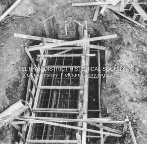 Eltham District Historical Society Inc
Album - Photograph, J.A. McDonald, Eltham-Greensborough Road, 26 July 1956
... 1956-07-26 ...Diamond Creek Bridge (Bridge Street Bridge) Showing tremie used upstream cylinder pier No. 1 26th July 1956.Record of various Shire of Eltham infrastructure works undertaken during the period of 1952-1962 involving bridge and road reconstruction projects, sometimes with Eltham Shire Council Project Reference numbers quoted. It was during this period that a number of significant improvements were made to roads and new bridges constructed within the shire that remain in place as of present day (2022). In many situations, the photos provide a tangible visible record of infrastructure that existed throughout the early days of the Shire. The album was put together by or under the direction of the Shire Engineer, J.A. McDonald.infrastructure, road construction, shire of eltham, bridge construction, bridge street bridge, eltham, eltham-greensborough road, 1956-07-26 -
 Ballarat Tramway Museum
Souvenir - Teaspoon, Perfection Plate, BTPS Teaspoon - tram 26, late 1980's early 1990's
Souvenir Teaspoon featuring Ballarat tram No. 26 in a round inset at the top of the tea spoon, contained within a plastic case. The teaspoon made by Perfection Plate, of the Caprice style or type. The case has yellow plastic base, with clear top with the words "Caprice by Perfection" On the rear of the case is the wording "Perfection". The teaspoon is silver plated, with the tram in a picture 22mm round. The teaspoon is marked "Caprice" on the rear. Tea spoon is 116mm long x 25mm wide. Case is 125mm high, 32mm wide, by 16mm deep. Made late 1980's, or early 1990's. See Reg Item 3556 for another example of this teaspoon. trams, tramways, teaspoons, sales items, btps -
 Bendigo Military Museum
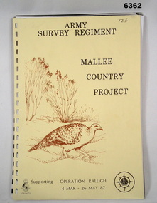
Administrative record - Army Survey Regiment - Malee Country Project 4 Mar - 26 May 1987, Army Survey Regiment, Bendigo, 30 Jun 1987
Project Mallee Country was support provided to Operation Raleigh by members of the Army Survey Regiment during the period 4 Mar - 26 May 1987. This is the report on their activities. Colonel John Blashford-Snell and Prince Charles launched Operation Drake in 1978, running youth projects from ships circumnavigating the globe, to develop self-confidence and leadership through adventure, scientific exploration and community service. In two years 414 young people took part in the round the world voyage, working on land-based projects in 16 countries. Following the success of Operation Drake, the much more ambitious Operation Raleigh was established in 1984, and ran for five years until 1989. The success of Operation Raleigh saw it continue on a permanent basis in 1988, with an emphasis on land-based expeditions.A4 Report, beige coloured cover, brown motif of Mallee Fowl, containing typed paper pages, poor quality photocopied photos and diagrams, unbound.royal australian survey corps, rasvy, fortuna, army survey regiment, army svy regt, asr -
Whitehorse Historical Society Inc.
Article, John Thomas McClare, 1/05/1956 12:00:00 AM
Obituary for John Thomas McClare.Obituary: John Thomas McClare, reprint from Mitcham Advertiser [1956]Obituary for John Thomas McClare.mcclare, john thomas -
Ringwood and District Historical Society
Pamphlet, Croydon Printers, Programme of events for the official opening of the A.C. Robertson Field, Ringwood - 26/10/1975, 26-Oct-75
Produced by the Ringwood Athletic Clubs participating in the official opening of the A.C. Robertson Field, Ringwood on 20-Oct-1975 at 2.30 p.m. Programme of events including Little Aths and Women's Amateur Athletic Club.Programme of events for the official opening of the A.C. Robertson Field, Ringwood. A four page programme of events, cream coloured with black printing and etching of a runner on front double page insert. +Additional Keywords: Robertson, A.C.Official Opening of the A.C. Robertson Field, Ringwood. -
 Ringwood and District Historical Society
Photograph - (Multiple), Maroondah City Council Award to Ringwood Historical Society 26 January 2019 - Community Event of the Year - 60th Birthday Open Day, 26/1/2019
This award is in recognition for the Society's 60th Birthday Open Day ExhibitionRDHS was nominated for an award for our Ringwood and District Heritage Open Day, held on 27 October 2018. The Society was announced as the winner at the Maroondah City Council Australia Day Awards Ceremony held at Ringwood Lake Reserve on 26th January 2019. It was accepted by RDHS President Russ Haines. This catalogue item consists of 4 photographs taken on the day by Ken Briscoe. (Edited/Cropped). See Item 11000 for the actual award certificates and BookletNone -
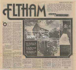 Eltham District Historical Society Inc
Newsclipping, Eltham, Report by Andrew Mckay, Pictures by Noel Butcher, The Herald, 26 July 1975, pp 21-22, 26 Jul 1975
Digital file only - Digitised by EDHS from a scrapbook on loan from Beryl Bradbury (nee Stokes), daughter of Frank Stokes.alistair knox, alma road, arthur munday, beryl bradbury (nee stokes) collection, cameron jackson, carina hack, charlie macgillicuddy, charlie stevenson, circus, clifton pugh, david stephens, dorian le gallienne, eltham, eltham college, eltham hotel, eltham living and learning centre, eltham town square, eltham village, george paul, graham bell, great hall, green wedge, harold holt, jazz, jim chinaman's road, justus jorgensen, kangaroo ground, lower plenty, marcus skipper, matcham skipper, montmorency, montsalvat, mud brick construction, mudbrick, myra skipper, professor dick downing, professor macmahon ball, professor richard downing, research (vic.), roger bell, shire of eltham, shire president, shopping centre, swiper's gully, tim burstall, white cloud cottage -
 Eltham District Historical Society Inc
Photograph, Hume and Hovell Monument, Broadford, Autumn Excursion, Hume and Hovell's 1824 expedition, 26 May 1996, 26/05/1996
[article by Bettina Woodburn in EDHS Newsletter No. 109, July 1996:] ON THE TRAIL OF HUME AND HOVELL - REPORT ON THE AUTUMN EXCURSION - On a green and fresh morning (Sunday 26th May 1996) the Cobb and Co coach (driven by the most obliging Peter Tampion) set off in a north easterly direction from Eltham to connect with Hume and Hovell's route on their 1824 explorations of central Victoria. The Society would follow a series of monuments erected for the 1924 centenary of the expedition from King Parrot Creek (Tuesday 7th December 1824), through Strath Creek, over Sunday Creek (Sunday 12th December 1824) at Broadford, Tullamarine, St Albans, Deer Park, through Werribee, skirting east of the You Yangs to Lara and Avalon Beach. Because their distance-measuring wheel had broken and a one degree mistake was made in calculations, the two leaders of the original group of six convict-companions arrived at Corio Bay, instead of the expected Western Port, discovered earlier by Flinders. From below Mt. Disappointment (Hume and Hovell's difficulties in "scrambling over brush and rock", "leeches in forest, as well as no water", "cutting grass 4-5 ft. high", dreadful scrub", "devil flies") we took an easier route, saw the Strath Creek memorial in ground fog and a wonderful "field of dreams", the Hume-Hovell privately owned cricket ground with its white picket boundary fence. Now, after a steep climb, in sunshine under gums we stretched and viewed magnificent rolling hills and fog-filled valleys - not "smoke from Aborigines' bush fires". After morning tea at Broadford we followed the Sunday Creek valley beside the Hume Freeway, passed the Wallan Wallan Rest Area (more appropriately Hume and Hovell Rest Area) to tum right at Beveridge. In Gellibrand Hill Park, near the headwaters of the Moonee Ponds Creek, we experienced the landscape the first European settlers saw - huge river red gums and rolling pastures. The gardens and sheltered courtyard of the 1840s, timber, brought from .....[?] prefabricated Woodlands Homestead, provided a pleasant lunch stop. We enjoyed a private tour, panoramic views over Melbourne and surroundings and the excitement of arriving and departing aircraft. Our next river crossing was at Werribee, "in a vast treeless plain", then we drove on by-ways no coach had previously travelled, to find "an immense sheet of water" salty Corio Bay, off-course to the west. In late afternoon of a super, calm, late autumn day we headed homewards. Back at Eltham we were rather surprised to find that we had travelled a total of 347 km. Thanks again to Russell Yeoman for his research and organization. What a wonderful day! Colour photographactivities, broadford, hume and hovell, monument -
 Eltham District Historical Society Inc
Photograph, Strath Creek, Autumn Excursion, Hume and Hovell's 1824 expedition, 26 May 1996, 26/05/1996
[article by Bettina Woodburn in EDHS Newsletter No. 109, July 1996:] ON THE TRAIL OF HUME AND HOVELL - REPORT ON THE AUTUMN EXCURSION - On a green and fresh morning (Sunday 26th May 1996) the Cobb and Co coach (driven by the most obliging Peter Tampion) set off in a north easterly direction from Eltham to connect with Hume and Hovell's route on their 1824 explorations of central Victoria. The Society would follow a series of monuments erected for the 1924 centenary of the expedition from King Parrot Creek (Tuesday 7th December 1824), through Strath Creek, over Sunday Creek (Sunday 12th December 1824) at Broadford, Tullamarine, St Albans, Deer Park, through Werribee, skirting east of the You Yangs to Lara and Avalon Beach. Because their distance-measuring wheel had broken and a one degree mistake was made in calculations, the two leaders of the original group of six convict-companions arrived at Corio Bay, instead of the expected Western Port, discovered earlier by Flinders. From below Mt. Disappointment (Hume and Hovell's difficulties in "scrambling over brush and rock", "leeches in forest, as well as no water", "cutting grass 4-5 ft. high", dreadful scrub", "devil flies") we took an easier route, saw the Strath Creek memorial in ground fog and a wonderful "field of dreams", the Hume-Hovell privately owned cricket ground with its white picket boundary fence. Now, after a steep climb, in sunshine under gums we stretched and viewed magnificent rolling hills and fog-filled valleys - not "smoke from Aborigines' bush fires". After morning tea at Broadford we followed the Sunday Creek valley beside the Hume Freeway, passed the Wallan Wallan Rest Area (more appropriately Hume and Hovell Rest Area) to tum right at Beveridge. In Gellibrand Hill Park, near the headwaters of the Moonee Ponds Creek, we experienced the landscape the first European settlers saw - huge river red gums and rolling pastures. The gardens and sheltered courtyard of the 1840s, timber, brought from .....[?] prefabricated Woodlands Homestead, provided a pleasant lunch stop. We enjoyed a private tour, panoramic views over Melbourne and surroundings and the excitement of arriving and departing aircraft. Our next river crossing was at Werribee, "in a vast treeless plain", then we drove on by-ways no coach had previously travelled, to find "an immense sheet of water" salty Corio Bay, off-course to the west. In late afternoon of a super, calm, late autumn day we headed homewards. Back at Eltham we were rather surprised to find that we had travelled a total of 347 km. Thanks again to Russell Yeoman for his research and organization. What a wonderful day! Colour photographactivities, monument, hume and hovell, murchison valley, strath creek -
 Eltham District Historical Society Inc
Photograph, Murchison Gap viewed from Strath Creek, Autumn Excursion, Hume and Hovell's 1824 expedition, 26 May 1996, 26/05/1996
[article by Bettina Woodburn in EDHS Newsletter No. 109, July 1996:] ON THE TRAIL OF HUME AND HOVELL - REPORT ON THE AUTUMN EXCURSION - On a green and fresh morning (Sunday 26th May 1996) the Cobb and Co coach (driven by the most obliging Peter Tampion) set off in a north easterly direction from Eltham to connect with Hume and Hovell's route on their 1824 explorations of central Victoria. The Society would follow a series of monuments erected for the 1924 centenary of the expedition from King Parrot Creek (Tuesday 7th December 1824), through Strath Creek, over Sunday Creek (Sunday 12th December 1824) at Broadford, Tullamarine, St Albans, Deer Park, through Werribee, skirting east of the You Yangs to Lara and Avalon Beach. Because their distance-measuring wheel had broken and a one degree mistake was made in calculations, the two leaders of the original group of six convict-companions arrived at Corio Bay, instead of the expected Western Port, discovered earlier by Flinders. From below Mt. Disappointment (Hume and Hovell's difficulties in "scrambling over brush and rock", "leeches in forest, as well as no water", "cutting grass 4-5 ft. high", dreadful scrub", "devil flies") we took an easier route, saw the Strath Creek memorial in ground fog and a wonderful "field of dreams", the Hume-Hovell privately owned cricket ground with its white picket boundary fence. Now, after a steep climb, in sunshine under gums we stretched and viewed magnificent rolling hills and fog-filled valleys - not "smoke from Aborigines' bush fires". After morning tea at Broadford we followed the Sunday Creek valley beside the Hume Freeway, passed the Wallan Wallan Rest Area (more appropriately Hume and Hovell Rest Area) to tum right at Beveridge. In Gellibrand Hill Park, near the headwaters of the Moonee Ponds Creek, we experienced the landscape the first European settlers saw - huge river red gums and rolling pastures. The gardens and sheltered courtyard of the 1840s, timber, brought from .....[?] prefabricated Woodlands Homestead, provided a pleasant lunch stop. We enjoyed a private tour, panoramic views over Melbourne and surroundings and the excitement of arriving and departing aircraft. Our next river crossing was at Werribee, "in a vast treeless plain", then we drove on by-ways no coach had previously travelled, to find "an immense sheet of water" salty Corio Bay, off-course to the west. In late afternoon of a super, calm, late autumn day we headed homewards. Back at Eltham we were rather surprised to find that we had travelled a total of 347 km. Thanks again to Russell Yeoman for his research and organization. What a wonderful day! Colour photographactivities, hume and hovell, murchison valley, murchison gap, strath creek -
 Eltham District Historical Society Inc
Photograph, Autumn Excursion, Hume and Hovell's 1824 expedition, 26 May 1996, 26/05/1996
[article by Bettina Woodburn in EDHS Newsletter No. 109, July 1996:] ON THE TRAIL OF HUME AND HOVELL - REPORT ON THE AUTUMN EXCURSION - On a green and fresh morning (Sunday 26th May 1996) the Cobb and Co coach (driven by the most obliging Peter Tampion) set off in a north easterly direction from Eltham to connect with Hume and Hovell's route on their 1824 explorations of central Victoria. The Society would follow a series of monuments erected for the 1924 centenary of the expedition from King Parrot Creek (Tuesday 7th December 1824), through Strath Creek, over Sunday Creek (Sunday 12th December 1824) at Broadford, Tullamarine, St Albans, Deer Park, through Werribee, skirting east of the You Yangs to Lara and Avalon Beach. Because their distance-measuring wheel had broken and a one degree mistake was made in calculations, the two leaders of the original group of six convict-companions arrived at Corio Bay, instead of the expected Western Port, discovered earlier by Flinders. From below Mt. Disappointment (Hume and Hovell's difficulties in "scrambling over brush and rock", "leeches in forest, as well as no water", "cutting grass 4-5 ft. high", dreadful scrub", "devil flies") we took an easier route, saw the Strath Creek memorial in ground fog and a wonderful "field of dreams", the Hume-Hovell privately owned cricket ground with its white picket boundary fence. Now, after a steep climb, in sunshine under gums we stretched and viewed magnificent rolling hills and fog-filled valleys - not "smoke from Aborigines' bush fires". After morning tea at Broadford we followed the Sunday Creek valley beside the Hume Freeway, passed the Wallan Wallan Rest Area (more appropriately Hume and Hovell Rest Area) to tum right at Beveridge. In Gellibrand Hill Park, near the headwaters of the Moonee Ponds Creek, we experienced the landscape the first European settlers saw - huge river red gums and rolling pastures. The gardens and sheltered courtyard of the 1840s, timber, brought from .....[?] prefabricated Woodlands Homestead, provided a pleasant lunch stop. We enjoyed a private tour, panoramic views over Melbourne and surroundings and the excitement of arriving and departing aircraft. Our next river crossing was at Werribee, "in a vast treeless plain", then we drove on by-ways no coach had previously travelled, to find "an immense sheet of water" salty Corio Bay, off-course to the west. In late afternoon of a super, calm, late autumn day we headed homewards. Back at Eltham we were rather surprised to find that we had travelled a total of 347 km. Thanks again to Russell Yeoman for his research and organization. What a wonderful day! Colour photographactivities, hume and hovell -
 Eltham District Historical Society Inc
Photograph, Sign to Hume and Hovell Cricket Ground, at Allandale Road, Strath Creek, Autumn Excursion, Hume and Hovell's 1824 expedition, 26 May 1996, 26/05/1996
[article by Bettina Woodburn in EDHS Newsletter No. 109, July 1996:] ON THE TRAIL OF HUME AND HOVELL - REPORT ON THE AUTUMN EXCURSION - On a green and fresh morning (Sunday 26th May 1996) the Cobb and Co coach (driven by the most obliging Peter Tampion) set off in a north easterly direction from Eltham to connect with Hume and Hovell's route on their 1824 explorations of central Victoria. The Society would follow a series of monuments erected for the 1924 centenary of the expedition from King Parrot Creek (Tuesday 7th December 1824), through Strath Creek, over Sunday Creek (Sunday 12th December 1824) at Broadford, Tullamarine, St Albans, Deer Park, through Werribee, skirting east of the You Yangs to Lara and Avalon Beach. Because their distance-measuring wheel had broken and a one degree mistake was made in calculations, the two leaders of the original group of six convict-companions arrived at Corio Bay, instead of the expected Western Port, discovered earlier by Flinders. From below Mt. Disappointment (Hume and Hovell's difficulties in "scrambling over brush and rock", "leeches in forest, as well as no water", "cutting grass 4-5 ft. high", dreadful scrub", "devil flies") we took an easier route, saw the Strath Creek memorial in ground fog and a wonderful "field of dreams", the Hume-Hovell privately owned cricket ground with its white picket boundary fence. Now, after a steep climb, in sunshine under gums we stretched and viewed magnificent rolling hills and fog-filled valleys - not "smoke from Aborigines' bush fires". After morning tea at Broadford we followed the Sunday Creek valley beside the Hume Freeway, passed the Wallan Wallan Rest Area (more appropriately Hume and Hovell Rest Area) to tum right at Beveridge. In Gellibrand Hill Park, near the headwaters of the Moonee Ponds Creek, we experienced the landscape the first European settlers saw - huge river red gums and rolling pastures. The gardens and sheltered courtyard of the 1840s, timber, brought from .....[?] prefabricated Woodlands Homestead, provided a pleasant lunch stop. We enjoyed a private tour, panoramic views over Melbourne and surroundings and the excitement of arriving and departing aircraft. Our next river crossing was at Werribee, "in a vast treeless plain", then we drove on by-ways no coach had previously travelled, to find "an immense sheet of water" salty Corio Bay, off-course to the west. In late afternoon of a super, calm, late autumn day we headed homewards. Back at Eltham we were rather surprised to find that we had travelled a total of 347 km. Thanks again to Russell Yeoman for his research and organization. What a wonderful day! Colour photographactivities, hume and hovell, allandale road, strath creek -
 Eltham District Historical Society Inc
Photograph, Autumn Excursion, Hume and Hovell's 1824 expedition, 26 May 1996, 26/05/1996
[article by Bettina Woodburn in EDHS Newsletter No. 109, July 1996:] ON THE TRAIL OF HUME AND HOVELL - REPORT ON THE AUTUMN EXCURSION - On a green and fresh morning (Sunday 26th May 1996) the Cobb and Co coach (driven by the most obliging Peter Tampion) set off in a north easterly direction from Eltham to connect with Hume and Hovell's route on their 1824 explorations of central Victoria. The Society would follow a series of monuments erected for the 1924 centenary of the expedition from King Parrot Creek (Tuesday 7th December 1824), through Strath Creek, over Sunday Creek (Sunday 12th December 1824) at Broadford, Tullamarine, St Albans, Deer Park, through Werribee, skirting east of the You Yangs to Lara and Avalon Beach. Because their distance-measuring wheel had broken and a one degree mistake was made in calculations, the two leaders of the original group of six convict-companions arrived at Corio Bay, instead of the expected Western Port, discovered earlier by Flinders. From below Mt. Disappointment (Hume and Hovell's difficulties in "scrambling over brush and rock", "leeches in forest, as well as no water", "cutting grass 4-5 ft. high", dreadful scrub", "devil flies") we took an easier route, saw the Strath Creek memorial in ground fog and a wonderful "field of dreams", the Hume-Hovell privately owned cricket ground with its white picket boundary fence. Now, after a steep climb, in sunshine under gums we stretched and viewed magnificent rolling hills and fog-filled valleys - not "smoke from Aborigines' bush fires". After morning tea at Broadford we followed the Sunday Creek valley beside the Hume Freeway, passed the Wallan Wallan Rest Area (more appropriately Hume and Hovell Rest Area) to tum right at Beveridge. In Gellibrand Hill Park, near the headwaters of the Moonee Ponds Creek, we experienced the landscape the first European settlers saw - huge river red gums and rolling pastures. The gardens and sheltered courtyard of the 1840s, timber, brought from .....[?] prefabricated Woodlands Homestead, provided a pleasant lunch stop. We enjoyed a private tour, panoramic views over Melbourne and surroundings and the excitement of arriving and departing aircraft. Our next river crossing was at Werribee, "in a vast treeless plain", then we drove on by-ways no coach had previously travelled, to find "an immense sheet of water" salty Corio Bay, off-course to the west. In late afternoon of a super, calm, late autumn day we headed homewards. Back at Eltham we were rather surprised to find that we had travelled a total of 347 km. Thanks again to Russell Yeoman for his research and organization. What a wonderful day! Colour photographactivities, hume and hovell -
 Eltham District Historical Society Inc
Photograph, Decorations at the celebration of Peter Bassett-Smith being named Eltham Citizen of the Year, 26 January 2001, 26/01/2001
Colour photographaustralia day awards, eltham citizen of the year, peter bassett-smith -
 Eltham District Historical Society Inc
Photograph, Decorations at the celebration of Peter Bassett-Smith being named Eltham Citizen of the Year, 26 January 2001, 26/01/2001
Colour photographaustralia day awards, eltham citizen of the year, peter bassett-smith -
 Eltham District Historical Society Inc
Photograph, Entertainment at the celebration of Peter Bassett-Smith being named Eltham Citizen of the Year, 26 January 2001, 26/01/2001
Colour photographaustralia day awards, eltham citizen of the year, peter bassett-smith -
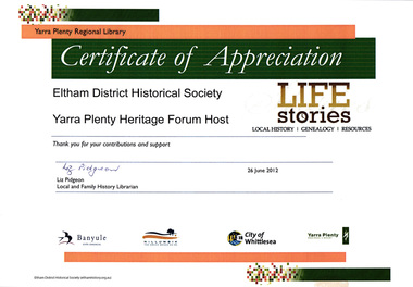 Eltham District Historical Society Inc
Certificate, Certificate of Appreciation, Yarra Plenty Regional Library to Eltham District Historical Society for hosting the Yarra Plenty Heritage Forum, 26 June 2012, 26/06/2012
EDHS hosted a quarterly meeting of the Yarra Plenty Heritage Group network of local history groups.A4 colour print certificate of appreciation, eltham district historical society, yarra plenty heritage forum, yarra plenty regional library -
 Eltham District Historical Society Inc
Photograph, Murchison Gap, Autumn Excursion, Hume and Hovell's 1824 expedition, 26 May 1996, 26/05/1996
[article by Bettina Woodburn in EDHS Newsletter No. 109, July 1996:] ON THE TRAIL OF HUME AND HOVELL - REPORT ON THE AUTUMN EXCURSION - On a green and fresh morning (Sunday 26th May 1996) the Cobb and Co coach (driven by the most obliging Peter Tampion) set off in a north easterly direction from Eltham to connect with Hume and Hovell's route on their 1824 explorations of central Victoria. The Society would follow a series of monuments erected for the 1924 centenary of the expedition from King Parrot Creek (Tuesday 7th December 1824), through Strath Creek, over Sunday Creek (Sunday 12th December 1824) at Broadford, Tullamarine, St Albans, Deer Park, through Werribee, skirting east of the You Yangs to Lara and Avalon Beach. Because their distance-measuring wheel had broken and a one degree mistake was made in calculations, the two leaders of the original group of six convict-companions arrived at Corio Bay, instead of the expected Western Port, discovered earlier by Flinders. From below Mt. Disappointment (Hume and Hovell's difficulties in "scrambling over brush and rock", "leeches in forest, as well as no water", "cutting grass 4-5 ft. high", dreadful scrub", "devil flies") we took an easier route, saw the Strath Creek memorial in ground fog and a wonderful "field of dreams", the Hume-Hovell privately owned cricket ground with its white picket boundary fence. Now, after a steep climb, in sunshine under gums we stretched and viewed magnificent rolling hills and fog-filled valleys - not "smoke from Aborigines' bush fires". After morning tea at Broadford we followed the Sunday Creek valley beside the Hume Freeway, passed the Wallan Wallan Rest Area (more appropriately Hume and Hovell Rest Area) to tum right at Beveridge. In Gellibrand Hill Park, near the headwaters of the Moonee Ponds Creek, we experienced the landscape the first European settlers saw - huge river red gums and rolling pastures. The gardens and sheltered courtyard of the 1840s, timber, brought from .....[?] prefabricated Woodlands Homestead, provided a pleasant lunch stop. We enjoyed a private tour, panoramic views over Melbourne and surroundings and the excitement of arriving and departing aircraft. Our next river crossing was at Werribee, "in a vast treeless plain", then we drove on by-ways no coach had previously travelled, to find "an immense sheet of water" salty Corio Bay, off-course to the west. In late afternoon of a super, calm, late autumn day we headed homewards. Back at Eltham we were rather surprised to find that we had travelled a total of 347 km. Thanks again to Russell Yeoman for his research and organization. What a wonderful day! Three colour photographsactivities, murchison gap, murchison valley