Showing 2589 items matching "aerial"
-
 Whitehorse Historical Society Inc.
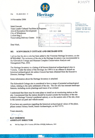
Letter - Correspondence, Schwerkolt Cottage and Orchard site, 14/11/2006 12:00:00 AM
Letter from Heritage Victoria to Mark Fawcett, City of Whitehorse, 16 November 2006 .Letter from Heritage Victoria to Mark Fawcett, City of Whitehorse, 16 November 2006 . Re. inclusion of Schwerkolt Cottage and orchard site in the Victorian Heritage Inventory, with plan and aerial photographLetter from Heritage Victoria to Mark Fawcett, City of Whitehorse, 16 November 2006 . fawcett, mark, schwerkolt cottage & museum complex, historic sites -
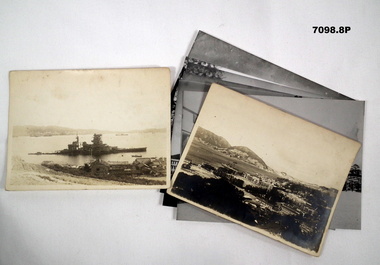 Bendigo Military Museum
Photograph - PHOTOGRAPHS, BCOF, 1946 - 47
Items in the collection re Clarence Shearing, refer Cat No 7089.16P for his service details.Photographs B & W some are copies. Two are of the 130th Australian General Hospital, BCOF HQ. One of a torpedoed ship. Aerial view of the Japanese Naval Academy. Four showing different views of the Naval Academy."A torpedoed Ship at Kojo Ferry Eta Jima" "An aerial view of the former Naval Academy - now HQ BCOF area - The building with the X is where I work"photographs, bcof, 130th, naval -
 Glenelg Shire Council Cultural Collection
Photograph - Photograph - aerial view of railway line between Heywood and Rennick, 03/05/1952
Victorian Railways aerial survey record print of the railway line between Heywood and Rennick (S.A. border) Black and white, white vertical strip on imageBack: 'Heywood - Rennick 21450 - 19721 266m 72 c' - all black ink. White sticker, black print 'Marp' Purple VR aerial survey stamp. '3 May 1952' - black stampvictorian railways, aerial photography -
Glenelg Shire Council Cultural Collection
Photograph - Photograph - Aerial Photo railway line between Heywood and Rennick, 03/05/1952
Victorian Railways aerial survey record print of the railway line between Heywood and Rennick (S.A. border) Black and white, white vertical strip on imageFront: 'to Rennick, Heywood from Melbourne' in the whites strip Back: 'Heywood - Rennick 21079 - 19370 235m72c Heywood' - all black ink. Purple VR aerial survey stamp. '3 May 1952' - black stamp -
Glenelg Shire Council Cultural Collection
Photograph - Photograph - Aerial Photo railway line between Heywood and Rennick, 03/05/1952
Victorian Railways aerial survey record print of the railway line between Heywood and Rennick (S.A. border) Black and white, white vertical strip on imageFront: Annotations in black texta added at a later date Back: 'Heywood - Rennick 21451 - 19722 267m 1c ' - all black ink. Purple VR aerial survey stamp. '3 May 1952' - black stamp -
Glenelg Shire Council Cultural Collection
Photograph - Aerial Survey Railway Record Print - 1952, 03/05/1952
These photos were found in a car that was left for recycling.Victorian Railways aerial survey record print of the railway line between Heywood and Rennick (S.A. border) Black and white, white vertical strip on image.Front: 'to Rennick, Heywood from Melbourne' in the white strip Back: 'Heywood - Rennick 21069 - 19360. 235m31c Heywood' - all black ink. Purple VR aerial survey stamp. '3 May 1952' - black stamp -
 Lakes Entrance Historical Society
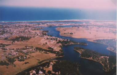
Photograph - North Arm Lakes Entrance, 1993c
Also second aerial photograph showing Blairs Road track to Wyanga Winery glimpse of Tarra Landing number 03857.1 size 10 x 15 cmAerial photograph of North Arm Frenchmans Gully and Wyanga Winery lower left Tarra Landing estate centre North Arm and Cunninghame Arm Lakes Entrance Victoriaaerial photograph, houses, settlement, township -
Glenelg Shire Council Cultural Collection
Photograph - Photograph - Aerial Photo railway line between Heywood and Rennick, 03/05/1952
Victorian Railways aerial survey record print of the railway line between Heywood and Rennick (S.A. border) Black and white, white vertical strip on imageFront: 'to Rennick, Heywood from Melbourn' in the whites strip Back: 'Heywood - Rennick 21078 - 19369 235m 70c Heywood' - all black ink. Purple VR aerial survey stamp. '3 May 1952' - black stamp -
Glenelg Shire Council Cultural Collection
Photograph - Photograph - Aerial Photo railway line between Heywood and Rennick, 03/05/1952
Victorian Railways aerial survey record print of the railway line between Heywood and Rennick (S.A. border) Black and white, white vertical strip on imageFront: Annotations in black pencil added at a later date Back: 'Heywood - Rennick 21149 - 19430 240m 79c Heywood' - all black ink. Purple VR aerial survey stamp. '3 May 1952' - black stamp -
Glenelg Shire Council Cultural Collection
Photograph - Photograph - Aerial Photo railway line between Heywood and Rennick, 03/05/1952
Victorian Railways aerial survey record print of the railway line between Heywood and Rennick (S.A. border) Black and white, white vertical strip on imageFront: Annotations in black texta added at a later date Back: 'Heywood - Rennick 21358 - 19629 258m 23c Heywood' - all black ink. Purple VR aerial survey stamp. '3 May 1952' - black stamp -
Glenelg Shire Council Cultural Collection
Photograph - Photograph - aerial view of railway line, 03/05/1952
Victorian Railways aerial survey record print of the railway line between Heywood and Rennick (S.A. border) Black and white, white vertical strip on imageFront: Notations in black pen, added at a later date Back: 'Heywood - Rennick 21082 - 19373 235m 73c Heywood' - all black ink. Purple VR aerial survey stamp. '3 May 1952' - black stampvictorian railways, aerial photography, train line -
Glenelg Shire Council Cultural Collection
Photograph - Photograph - Aerial Photo railway line between Heywood and Rennick, 03/05/1952
Victorian Railways aerial survey record print of the railway line between Heywood and Rennick (S.A. border) Black and white, white vertical strip on imageFront: 'to Rennick, Heywood from Melbourn' in the whites strip Back: 'Heywood - Rennick 21077 - 19368 235m 67c Heywood' - all black ink. Purple VR aerial survey stamp. '3 May 1952' - black stamp -
Glenelg Shire Council Cultural Collection
Photograph - Aerial Survey Railway Record Print – 1952, 03/05/1952
Victorian Railways aerial survey record print of the railway line between Heywood and Rennick (S.A. border) Black and white, white vertical strip on image.Front: Annotations in black ink added at a later date Back: 'Heywood - Rennick 21151 - 19432 241m 14c Heywood' - all black ink. Purple VR aerial survey stamp. '3 May 1952' - black stamp -
 Federation University Historical Collection
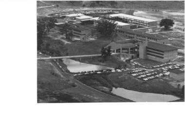
Photograph - Photograph, Black and White, Ballarat Institute of Advanced Education Mount Helen Campus, 1974, 1974
Aerial view of Ballarat Institute of Advanced Education Mount Helen Campus. It shows the oval and two dams in close proximity to the E.J. Barker Library. 1974ballarat institute of advanced education, library, mt helen, aerial, mount helen campus, e.j. barker library, mount helen library -
Stawell Historical Society Inc
Map, Stawell Gold Mine, Stawell Gold Mine Photo Map of Stawell Township showing Underground Declines in mining lease, 2007
SGM photo Map 2007 Produced for Public Consultation over Big Hill Open Pit Proposal. Aerial Views Stawellmining, gold, map -
 Forests Commission Retired Personnel Association (FCRPA)
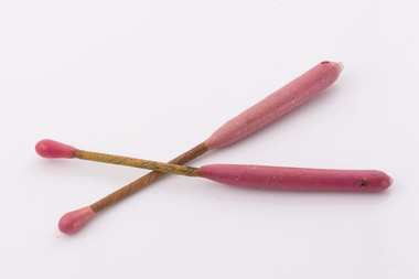
Delayed Action Incendiary Device (DAID), Bryant and May - Richmond, Large double ended match
The Forests Commission developed the use of helicopters for aerial ignition from the mid 1960s. Bryant and May at Richmond worked with the Commission to develop a Delayed Action Incendiary Device. DAIDs as the were known, had an overall length of 180 mm, striker end length - 10 mm. Ignition end length - 80 mm, then a layer of high melting point wax (to prevent accidental ignition when rubbing together in transit). Both ends coated with a modified match head compound with safety fuse exposed length between coated match ends. There was a 17-second delay from when the small end was struck to an intense flaming of the large end, which lasted for 40 seconds. DAIDs were dangerous so were stored in a metal box outside the helicopter along with a disposable striker patch attached with a quick release pin to a special half-door. The first test was with a Bell 47G on 4 October 1967 and the first use, anywhere in the world, of DAIDs to backburn a large bushfire was undertaken in north eastern Victoria in February 1968. There was a crash of an FCV helicopter conducting aerial ignition near Wandiligong on 19 April 1978 with the tragic death of two forest officers and their pilot. The crash led to the immediate end of the use of DAIDs and the adoption of the safer Premo ping-pong ball incendiary machine which originally came from Canada but was modified at the Altona workshops. Overall, the development of aerial ignition techniques by the Forests Commission from the mid-1960s resulted in a steady climb in the area burnt each year…. peaking at 477,000 ha in 1980-81 and with an impressive 10-year rolling average of 220,000 ha around the time of 1983 Ash Wednesday Bushfires.Developed in Victoria for aerial ignitionLarge double ended match used for aerial ignition and back burning by dropping from a helicopterbushfire, forests commission victoria (fcv) -
 Department of Energy, Environment and Climate Action
Delayed Action Incendiary Device (DAID)
The Forests Commission developed the use of helicopters for aerial ignition from the mid 1960s. Bryant and May at Richmond worked with the Commission to develop a Delayed Action Incendiary Device. DAIDs as the were known, had an overall length of 180 mm, striker end length - 10 mm. Ignition end length - 80 mm, then a layer of high melting point wax (to prevent accidental ignition when rubbing together in transit). Both ends coated with a modified match head compound with safety fuse exposed length between coated match ends. There was a 17-second delay from when the small end was struck to an intense flaming of the large end, which lasted for 40 seconds. DAIDs were dangerous so were stored in a metal box outside the helicopter along with a disposable striker patch attached with a quick release pin to a special half-door. The first test was with a Bell 47G on 4 October 1967 and the first use, anywhere in the world, of DAIDs to backburn a large bushfire was undertaken in north eastern Victoria in February 1968. There was a crash of an FCV helicopter conducting aerial ignition near Wandiligong on 19 April 1978 with the tragic death of two forest officers and their pilot. The crash led to the immediate end of the use of DAIDs and the adoption of the safer Premo ping-pong ball incendiary machine which originally came from Canada but was modified at the Altona workshops. Overall, the development of aerial ignition techniques by the Forests Commission from the mid-1960s resulted in a steady climb in the area burnt each year…. peaking at 477,000 ha in 1980-81 and with an impressive 10-year rolling average of 220,000 ha around the time of 1983 Ash Wednesday Bushfires.Developed in Victoria for aerial ignition by the FCV and Byant & MayLarge double ended match used for aerial ignition and back burning by dropping from a helicopterforests commission victoria (fcv), bushfire, planned burning -
 Vision Australia
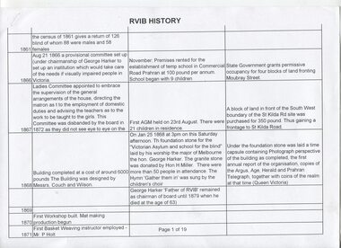
Document - Text, RVIB History
19 pages in table format, of events that occurred and people who were involved with the RVIB, and 1 page showing an aerial view of an unknown area. Based upon the Nipper document, this table was created by Jo Ann Matthews and C.H. Nipper.19 pages in table format, of events that occurred and people who were involved with the RVIB, and 1 page showing an aerial view of an unknown areanon-fictionelizabeth maxwell, neil maxwell, royal victorian institute for the blind -
Glenelg Shire Council Cultural Collection
Photograph - Aerial Survey Railway Record Print – 1952, 03/05/1952
Victorian Railways aerial survey record print of the railway line between Heywood and Rennick (S.A. border) Black and white, white vertical strip on imageFront: Annotations in red and black ink made at a later date Back: 'Heywood - Rennick 21085 - 19376 236m 9c Heywood' - all black ink. Purple VR aerial survey stamp. '3 May 1952' - black stamp -
Glenelg Shire Council Cultural Collection
Photograph - Photograph - Aerial Photo railway line between Heywood and Rennick, 03/05/1952
Victorian Railways aerial survey record print of the railway line between Heywood and Rennick (S.A. border) Black and white, white vertical strip on imageFront: annotations in red and black ink, made at a later date Back: 'Heywood - Rennick 21084 - 19375 235m 31c Heywood' - all black ink. Purple VR aerial survey stamp. '3 May 1952' - black stamp -
 Phillip Island and District Historical Society Inc.
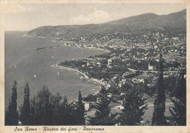
Photograph, 1950
Personal communication from Europe to relative (Aunt Elsie) in San Remo dated 17/06/1951Aerial view of San Remo coastline with row of various Pine Trees across foreground. Hills in background. Pier at top left. Shows town area of San Remo in Italy, Europe.San Remo - Riviera Dei Fiori - Panoramaphotography, photographs, aerial view - coastal view - san remo europe, black & white photograph, comparison views san remo, aerial -
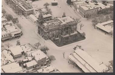 Bendigo Historical Society Inc.
Photograph - W. D. MASON COLLECTION: BENDIGO TOWN HALL, 1920-1930
Aerial photograph, Bendigo Town Hall, in centre of picture. Sign on top of Town Hall 'Bendigo Drome 7 miles' Also in photo, Sandhurst Hotel; Public Offices under-construction; the Metropolitan Hotel; the Market, another hotel .The photo was taken by Sir Raymond Garrett around the late 1920s early 1930s. His daughter, Ann Kelly, donated the photo.Sir Raymond Garrettphotograph, aerial, bendigo -
Glenelg Shire Council Cultural Collection
Photograph - Photograph - Aerial Photo railway line between Heywood and Rennick, 03/05/1952
Victorian Railways aerial survey record print of the railway line between Heywood and Rennick (S.A. border) Black and white, white vertical strip on imageFront: Annotations in red ink and black texta, added at a later date Back: 'Heywood - Rennick 21530 - 19793 274m 9c Puralka ' - all black ink. Purple VR aerial survey stamp. '3 May 1952' - black stamp -
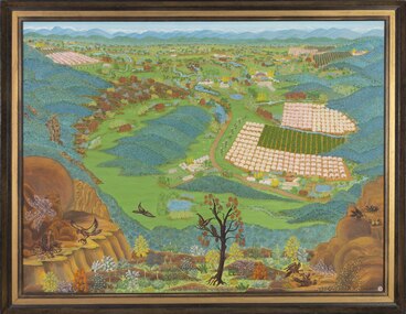 Wangaratta Art Gallery
Painting, Lorna Chick, Up Where The Eagles Nest, 1969
Lorna Chick was a local artist whose works depict farming and community landscapes, which reflected her main occupation of living and working on the family farm with her husband and two sons. Chick was a naïve artist who used the aerial viewpoint as a constant device in her landscapes. Her naïve art style allowed her to distort the common notion of landscape paintings being horizontal viewpoints, bringing a different understanding to her artwork.naïve artRural City of Wangaratta Collection, purchased with funds from the Wangaratta Art CouncilA rectangular aerial landscape oil painting of a farming community overlooked by eagles painted using vibrant coloursObverse: LORNA CHICK ©wangaratta art gallery, lorna chick, landscape, farming, eagles, north east victoria, painting -
Port Fairy Historical Society Museum and Archives
Photograph
Aerial view across the Moyne river Black and white photograph of Martins Point, river moyne and the pudney grounds from the air aerial, moyne, river, martin's point, port fairy, barge, dredge, pudney ground, griffith island -
Port Melbourne Historical & Preservation Society
Photograph - Aerial view of (finally) in-filled Lagoon, Port Melbourne, 1931
Image seems to be one of several aerial shots around 1931, possibly all shot from one flight. Aerial photo of Port Melbourne c1931 showing clearly the finally filled Lagoon, and central area from Gasworks to past Bay Street, from Town Hall to Town Pier. Cable tram cars can be seen on Bay Streetsandridge lagoon, built environment -
Glenelg Shire Council Cultural Collection
Photograph - Photograph - Aerial Photo railway line between Heywood and Rennick, 03/05/1952
Victorian Railways aerial survey record print of the railway line between Heywood and Rennick (S.A. border) Black and white, white vertical strip on imageFront: Annotations in red biro added at a later date Back: 'Heywood - Rennick 21356 - 19627 258m 6c ' - all black ink. White sticker, black print 'Winnap' Purple VR aerial survey stamp. '3 May 1952' - black stamp -
Glenelg Shire Council Cultural Collection
Photograph - Photograph - Aerial Photo railway line between Heywood and Rennick, 03/05/1952
Victorian Railways aerial survey record print of the railway line between Heywood and Rennick (S.A. border) Black and white, white vertical strip on imageFront: Annotations in red ink added at a later date Back: 'Heywood - Rennick 21391 - 19662 261m 18c ' - all black ink. White sticker, black print 'Dartmoor' Purple VR aerial survey stamp. '3 May 1952' - black stamp -
Glenelg Shire Council Cultural Collection
Photograph - Photograph - Aerial Photo railway line between Heywood and Rennick, 03/05/1952
Victorian Railways aerial survey record print of the railway line between Heywood and Rennick (S.A. border) Black and white, white vertical strip on imageFront: Annotations in red biro added at a later date Back: 'Heywood - Rennick 21297 - 19564 254m 2c Heywood' - all black ink. White sticker with 'GREENWALD' printed on it. Purple VR aerial survey stamp. '3 May 1952' - black stamp -
Glenelg Shire Council Cultural Collection
Photograph - Photograph - Aerial Photo railway line between Heywood and Rennick, 03/05/1952
Victorian Railways aerial survey record print of the railway line between Heywood and Rennick (S.A. border) Black and white, white vertical strip on imageFront: Annotations in red ink and black texta, added at a later date Back: 'Heywood - Rennick 21529 - 19792 2m c ' - all black ink. White sticker, black print -'Puralka' Purple VR aerial survey stamp. '3 May 1952' - black stamp