Showing 1537 items matching "aerial photograph"
-
 Whitehorse Historical Society Inc.
Document, Australian Tesselated Tile Co. Pty. Ltd, 1935
... Aerial photograph of the Australian Tesselated Tile Co... photographs Mitcham Aerial photograph of the Australian Tesselated ...Aerial photograph of the Australian Tesselated Tile Co. site at Mitcham c. 1935.Aerial photograph of the Australian Tesselated Tile Co. site at Mitcham c. 1935.Aerial photograph of the Australian Tesselated Tile Co. site at Mitcham c. 1935.australian tesselated tile co. pty. ltd., aerial photographs, mitcham -
 Whitehorse Historical Society Inc.
Photograph, Houses of Edgar & Stanley Walker in Mitcham
... Black and white aerial photograph showing the Mitcham... aerial photograph showing the Mitcham houses of Edgar and Stanley ...The house in the top right of the photo was built in 1922 for Edgar Walker. The house at 8 Meerut Street has been used as a hospital, and is on the Whitehorse historical register. The house in the bottom right of the photo was built c1934 for Stanley Walker, at 456 Mitcham Road, Mitcham.Black and white aerial photograph showing the Mitcham houses of Edgar and Stanley Walkerwalker, edgar edwardes, stanley, houses, mitcham road, mitcham, no.456, meerut street, no.8, heritage overlay, city of whitehorse -
 St Patrick's Old Collegians Association (SPOCA)
Photograph - Buildings, Other, ACU, SPJC Room E
... and large aerial photograph... and large aerial photograph Photograph Buildings, Other, ACU, SPJC ... -
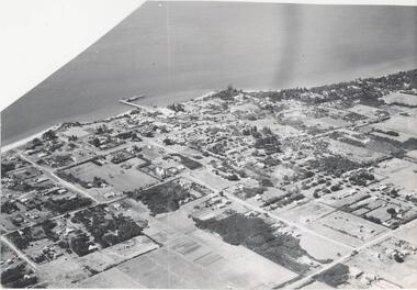 Phillip Island and District Historical Society Inc.
Photograph, Bryant West
... Aerial photograph - panoramic view of Cowes looking north... phillip island john jenner bryant west Aerial photograph ...One of a collection of over 400 photographs in an album commenced in 1960 and presented to the Phillip Island & Westernport Historical Society by the Shire of Phillip Island.Aerial photograph - panoramic view of Cowes looking north-east with Jetty and Foreshore in backgroundlocal history, photography, photographs, cowes foreshore, jetty, cowes, beaches, aerial view of cowes, aerial view of cowes phillip island, john jenner, bryant west -
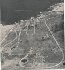 Phillip Island and District Historical Society Inc.
Photograph
... Early aerial photograph of the Phillip Island Motor Race... bryant west Early aerial photograph of the Phillip Island Motor ...One of a collection of over 400 photographs in an album commenced in 1960 and presented to the Phillip Island & Westernport Historical Society by the Shire of Phillip IslandEarly aerial photograph of the Phillip Island Motor Race Track - c. 1960'slocal history, photography, phillip island motor race track, black & white photograph, phillip island race track, john jenner, bryant west -
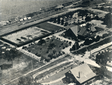
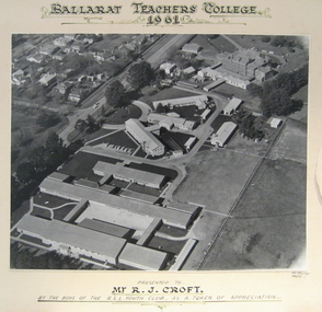 Federation University Historical Collection
Photograph - Photograph - Black and White, Ballarat Teachers' College, Gillies Street, 1961, 1961
... Aerial photograph of the Gillies Street Campus of Ballarat... of appreciation Aerial photograph of the Gillies Street Campus of Ballarat ...The Ballarat Teachers' College was established after the Victorian State Government and the State Education Department decided to establish two provincial teachers' colleges, at Ballarat and Bendigo. On 04 May 1926 W.H. Ellwood (Principal), Miss A. Bouchier, and Mr A.B. Jones, welcomed the first enrolment of 61 students to undertake the one year course. In 1927 the College moved to the former Ballarat East Town Hall in Barkly Street, which was remodelled for their use. It closed in December 1931 due to the Great Depression. In 1946 Ballarat Teachers' College reopened and relocated to the Dana Street State School. The building used by the Teachers' College was the original bluestone building facing Doveton Street South. It was originally planned to open as a women's college, for whom the residence at 130 Victoria Street was purchased, but the decision was made to admit resident men from Ballarat. Mr T.W. Turner was appointed as Principal in 1951 and directed the introduction of a two year course for the Trained Primary Teachers' Certificate. The former one year course was terminated at the end of 1951. In 1958 the College was relocated to a custom built facility at Gillies Street, in close proximity to the Ballarat Botanical Gardens. Numbers increased with the introduction of the Trained Infant Teachers' Certificate course under the guidance of Mary Egan. With the introduction of a three year Diploma Course in 1968 accommodation became cramped. The introduction of the Diploma of Teaching (Primary) led to the Trained Infant Teachers' Certificate being discontinued in 1969, and the end of the Trained Primary Teachers' Certificate in 1969. Secondary Art and Craft students began studies at Ballarat Teachers' College in 1969 under Mr Ted Doney. In 1971 Mr D. Watson was appointed Principal. The State College of Victoria was proclaimed by Order in Council on 24 July 1973, and Ballarat Teachers' College became a constituent college of the State College of Victoria, and was known as State College of Victoria, Ballarat. By 1975 the College moved to Mount Helen as part of the Ballarat College of Advanced Education. Pre service teachers currently undertake their studies on the Mount Helen Campus of Federation University. ("Ruffians Attempted to Carry of the School Tent: A History of State Education in Ballarat", 1974, p73-4.) Aerial photograph of the Gillies Street Campus of Ballarat Teachers' College glued onto card."Ballarat Teachers' College 1961 presented to R.J. Croft by the boys of the RSL Youth Club, as a token of appreciationballarat teachers' college, r.j. croft, rsl youth club -
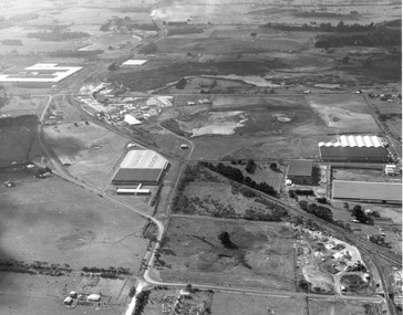
Whitehorse Historical Society Inc.
Map, Whitehorse Road, Mitcham, 1972
... Enlarged aerial photograph of area around intersection... Ringwood Maroondah Highway Aerial photographs Enlarged aerial ...Enlarged aerial photograph of area around intersection of Whitehorse Road and Heatherdale Roads, Mitcham.Enlarged aerial photograph of area around intersection of Whitehorse Road and Heatherdale Roads, Mitcham.Enlarged aerial photograph of area around intersection of Whitehorse Road and Heatherdale Roads, Mitcham.whitehorse road, mitcham, heatherdale road, mitcham, ringwood, maroondah highway, aerial photographs -
Whitehorse Historical Society Inc.
Map, Springvale Road, 1968
... Aerial photograph of cnr Springvale Road and Burwood... Mitcham melbourne Aerial photographs Highbury Road Burwood East ...Aerial photograph of cnr Springvale Road and Burwood Highway, south past Highbury Road.Aerial photograph of cnr Springvale Road and Burwood Highway, south past Highbury Road.Aerial photograph of cnr Springvale Road and Burwood Highway, south past Highbury Road.aerial photographs, highbury road, burwood east, burwood highway, burwood east, springvale road, burwood east -
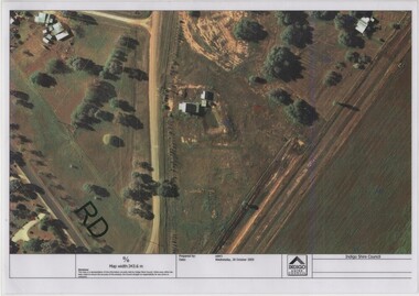 Rutherglen Historical Society
Image, Indigo Shire Council, 28/10/2009
... Laminated aerial photograph of Gold Battery site, believed... aerial photograph of Gold Battery site, believed taken before ...When operational, the Gold Battery used cyanide in its processing processes. The land surrounding it required remediation before it could be handed over to Indigo Shire for public use. The land has since been planted with pasture and native plants. The Gold Battery has been restored to working condition, and can be viewed by collecting a ticket from the Rutherglen Wine Experience and Visitor Information Centre.Laminated aerial photograph of Gold Battery site, believed taken before land remediation.gold battery, gold processing -
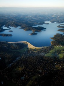 Southern Sherbrooke Historical Society Inc.
Photograph - Cardinia Reservoir from the air
... Aerial photograph of Cardinia Reservoir taken in 2020... Belgrave Heights 3160 yarra-valley-and-the-dandenong-ranges Aerial ...Aerial photograph of Cardinia Reservoir taken in 2020, showing the face of the main dam wall. -
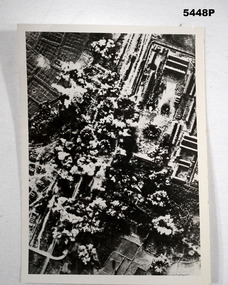 Bendigo Military Museum
Photograph - PHOTOGRAPH, AERIAL BOMBING, 1944.-1950
... PHOTOGRAPH, AERIAL BOMBING... are some letters and 43976 Black and white photograph taken during ...Refer to Cat 5445.2Black and white photograph taken during the bombing raid. In the phot can be seen rice paddies,train lines, roads and a camp of some sort, trenches .Rear Written” Nong Pladlik P.O.W camp 2nd bombing raid on camp Dec 3rd 1944 . 7 Killed Ist bombing on camp sept 7th 1944 93 Killed Stamp Imperial War Museum, Lambeth Road Wader S E 1 overwritten on stamp are some letters and 43976 ww2, p.o.w, thailand -
Glenelg Shire Council Cultural Collection
Photograph - Photograph - Aerial view from NE Portland Harbour, c. 1967
... Photograph - Aerial view from NE Portland Harbour... Pier still in existence. Photograph Photograph - Aerial view ...Port of Portland Authority archives.Front: 19 June 1997 Back: 19 June 1997port of portland archives -
 Glenelg Shire Council Cultural Collection
Photograph - Photograph - Aerial view of Australian Estates (Portland) Pty Ltd Wool Process, n.d
... Photograph - Aerial view of Australian Estates (Portland.... Photograph Photograph - Aerial view of Australian Estates (Portland ...Port of Portland Authority archives.Front: (no inscriptions) Back: (no inscriptions)port of portland archives -
 Glenelg Shire Council Cultural Collection
Photograph - Photograph - aerial view of Portland, 1988
... Photograph - aerial view of Portland... Photograph Photograph - aerial view of Portland Division of Survey ...Census Project No. 1995. Portland Dec. 1988.Aerial view of the "City of Portland" and surrounding rural area to a scale of 1:10,000 Aerial Photomosaic of Portland Bay, 1988Front: (no inscriptions) Back: (no inscriptions)aerial photography, central portland, portland harbour -
Glenelg Shire Council Cultural Collection
Photograph - Photograph - aerial view of Borthwicks, n.d
... Photograph - aerial view of Borthwicks... factory and fields. Photograph Photograph - aerial view ...Glenelg Shire Council RecordsAerial view of Borthwick's factory and fields.Front: (no inscriptions) Back: (no inscriptions)thomas borthwick and sons, abattoir, portland -
Glenelg Shire Council Cultural Collection
Photograph - Photograph - aerial view of Portland, 1970
... Photograph - aerial view of Portland... Photograph Photograph - aerial view of Portland ...Black and white aerial view of central Portland 1970. Image depicts residential areas in foreground and Portland Harbour in background. Framedaerial photography, central portland, portland harbour, residential -
Glenelg Shire Council Cultural Collection
Photograph - Photograph - Aerial Photo railway line between Heywood and Rennick, 03/05/1952
... Photograph - Aerial Photo railway line between Heywood and... strip on image Photograph Photograph - Aerial Photo railway line ...Victorian Railways aerial survey record print of the railway line between Heywood and Rennick (S.A. border) Black and white, white vertical strip on imageBack: 'Heywood - Rennick 21219 - 19500 247m 72c Heywood' - all black ink. Purple VR aerial survey stamp. '3 May 1952' - black stamp -
Glenelg Shire Council Cultural Collection
Photograph - Photograph - Aerial Photo railway line between Heywood and Rennick, 03/05/1952
... Photograph - Aerial Photo railway line between Heywood and... on image Photograph Photograph - Aerial Photo railway line between ...Victorian Railways aerial survey record print of the railway line between Heywood and Rennick (S.A. border) Black and white, white vertical strip on imageBack: 'Heywood - Rennick 21357 - 19628 258m 16c' - all black ink. Purple VR aerial survey stamp. '3 May 1952' - black stamp -
Glenelg Shire Council Cultural Collection
Photograph - Photograph - Aerial Photo railway line between Heywood and Rennick, 03/05/1952
... Photograph - Aerial Photo railway line between Heywood and... vertical strip on image Photograph Photograph - Aerial Photo ...Victorian Railways aerial survey record print of the railway line between Heywood and Rennick (S.A. border) Black and white, white vertical strip on imageFront: Annotations in black and blue ink, added at a later date Back: 'Heywood - Rennick 21222 - 19503 248m 16c Heywood' - all black ink.. White sticker with 'LYONS' printed on it. '3 May 1952' - black stamp -
Glenelg Shire Council Cultural Collection
Photograph - Photograph - Aerial Photo railway line between Heywood and Rennick, 03/05/1952
... Photograph - Aerial Photo railway line between Heywood and... strip on image Photograph Photograph - Aerial Photo railway line ...Victorian Railways aerial survey record print of the railway line between Heywood and Rennick (S.A. border) Black and white, white vertical strip on imageBack: 'Heywood - Rennick 21074 - 19365 235m 55c Heywood' - all black ink. Purple VR aerial survey stamp. '3 May 1952' - black stamp -
Glenelg Shire Council Cultural Collection
Photograph - Photograph - Aerial Photo railway line between Heywood and Rennick, 03/05/1952
... Photograph - Aerial Photo railway line between Heywood and... on image Photograph Photograph - Aerial Photo railway line between ...Victorian Railways aerial survey record print of the railway line between Heywood and Rennick (S.A. border) Black and white, white vertical strip on imageBack: 'Heywood - Rennick 21395 - 19666 261m 49c ' - all black ink. Purple VR aerial survey stamp. '3 May 1952' - black stamp -
Glenelg Shire Council Cultural Collection
Photograph - Photograph - Aerial Photo railway line between Heywood and Rennick, 03/05/1952
... Photograph - Aerial Photo railway line between Heywood and... on image Photograph Photograph - Aerial Photo railway line between ...Victorian Railways aerial survey record print of the railway line between Heywood and Rennick (S.A. border) Black and white, white vertical strip on imageBack: 'Heywood - Rennick 21385 - 19656 260m 53c' - all black ink. Purple VR aerial survey stamp. '3 May 1952' - black stamp -
Glenelg Shire Council Cultural Collection
Photograph - Photograph - Aerial Photo railway line between Heywood and Rennick, 03/05/1952
... Photograph - Aerial Photo railway line between Heywood and... on image Photograph Photograph - Aerial Photo railway line between ...Victorian Railways aerial survey record print of the railway line between Heywood and Rennick (S.A. border) Black and white, white vertical strip on imageFront: annotations in red and black ink, made at a later date Back: 'Heywood - Rennick 21084 - 19375 235m 31c Heywood' - all black ink. Purple VR aerial survey stamp. '3 May 1952' - black stamp -
Glenelg Shire Council Cultural Collection
Photograph - Photograph - Aerial Photo railway line between Heywood and Rennick, 03/05/1952
... Photograph - Aerial Photo railway line between Heywood and... on image Photograph Photograph - Aerial Photo railway line between ...Victorian Railways aerial survey record print of the railway line between Heywood and Rennick (S.A. border) Black and white, white vertical strip on imageBack: 'Heywood - Rennick 21220 - 19501 248m Heywood' - all black ink. Purple VR aerial survey stamp. '3 May 1952' - black stamp -
Glenelg Shire Council Cultural Collection
Photograph - Photograph - Aerial Photo railway line between Heywood and Rennick, 03/05/1952
... Photograph - Aerial Photo railway line between Heywood and... on image Photograph Photograph - Aerial Photo railway line between ...Victorian Railways aerial survey record print of the railway line between Heywood and Rennick (S.A. border) Black and white, white vertical strip on imageBack: 'Heywood - Rennick 21384 - 19625 257m 67c ' - all black ink. Purple VR aerial survey stamp. '3 May 1952' - black stamp -
Glenelg Shire Council Cultural Collection
Photograph - Photograph - Aerial Photo railway line between Heywood and Rennick, 03/05/1952
... Photograph - Aerial Photo railway line between Heywood and... vertical strip on image Photograph Photograph - Aerial Photo ...Victorian Railways aerial survey record print of the railway line between Heywood and Rennick (S.A. border) Black and white, white vertical strip on imageFront: Annotations in red biro added at a later date Back: 'Heywood - Rennick 21356 - 19627 258m 6c ' - all black ink. White sticker, black print 'Winnap' Purple VR aerial survey stamp. '3 May 1952' - black stamp -
Glenelg Shire Council Cultural Collection
Photograph - Photograph - Aerial Photo railway line between Heywood and Rennick, 03/05/1952
... Photograph - Aerial Photo railway line between Heywood and... on image Photograph Photograph - Aerial Photo railway line between ...Victorian Railways aerial survey record print of the railway line between Heywood and Rennick (S.A. border) Black and white, white vertical strip on imageBack: 'Heywood - Rennick 21452 - 19723 267 m 11 c ' - all black ink. Purple VR aerial survey stamp. '3 May 1952' - black stamp -
Glenelg Shire Council Cultural Collection
Photograph - Photograph - Aerial Photo railway line between Heywood and Rennick, 03/05/1952
... Photograph - Aerial Photo railway line between Heywood and... strip on image Photograph Photograph - Aerial Photo railway line ...Victorian Railways aerial survey record print of the railway line between Heywood and Rennick (S.A. border) Black and white, white vertical strip on imageBack: 'Heywood - Rennick 21223 - 19504 248m 23c Heywood' - all black ink. Purple VR aerial survey stamp. '3 May 1952' - black stamp -
Glenelg Shire Council Cultural Collection
Photograph - Photograph - Aerial Photo railway line between Heywood and Rennick, 03/05/1952
... Photograph - Aerial Photo railway line between Heywood and... strip on image Photograph Photograph - Aerial Photo railway line ...Victorian Railways aerial survey record print of the railway line between Heywood and Rennick (S.A. border) Black and white, white vertical strip on imageBack: 'Heywood - Rennick 21087 - 19378 236m 18c Heywood' - all black ink. Purple VR aerial survey stamp. '3 May 1952' - black stamp -
Glenelg Shire Council Cultural Collection
Photograph - Photograph - Aerial Photo railway line between Heywood and Rennick, 03/05/1952
... Photograph - Aerial Photo railway line between Heywood and... strip on image Photograph Photograph - Aerial Photo railway line ...Victorian Railways aerial survey record print of the railway line between Heywood and Rennick (S.A. border) Black and white, white vertical strip on imageBack: 'Heywood - Rennick 21083 - 19374 235m 78c Heywood' - all black ink. Purple VR aerial survey stamp. '3 May 1952' - black stamp