Showing 640 items
matching and footpaths.
-
 Eltham District Historical Society Inc
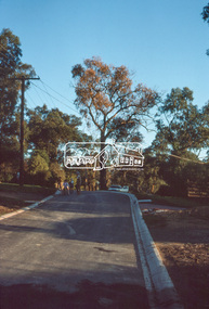
Slide, Andrews Street, Eltham, May 1983
One of a series of images of roads and infrastructure taken by Eltham Shire Council Planning and Engineering officers, May 1983 specifically looking at Private Street Schemes post road construction/sealing operations35 mm colour positive transparency (1 of 21) Mount - Kodak Kodachrome Cardroads, infrastructure, road sealing, footpaths and gutters, private street scheme, eltham, andrews street -
 Eltham District Historical Society Inc
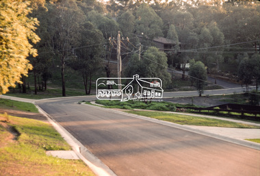
Slide, Park Road, Eltham, May 1983
One of a series of images of roads and infrastructure taken by Eltham Shire Council Planning and Engineering officers, May 1983 specifically looking at Private Street Schemes post road construction/sealing operations35 mm colour positive transparency (1 of 21) Mount - Kodak Kodachrome Cardroads, infrastructure, road sealing, footpaths and gutters, private street scheme, eltham, park road -
 Eltham District Historical Society Inc
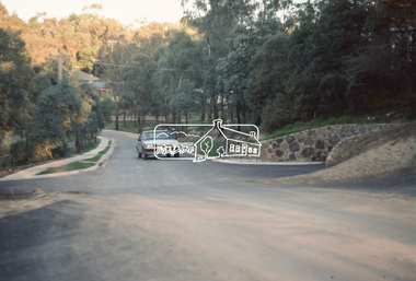
Slide, Park Road, Eltham, May 1983
One of a series of images of roads and infrastructure taken by Eltham Shire Council Planning and Engineering officers, May 1983 specifically looking at Private Street Schemes post road construction/sealing operations35 mm colour positive transparency (1 of 21) Mount - Kodak Kodachrome Cardroads, infrastructure, road sealing, footpaths and gutters, private street scheme, eltham, park road, t-bowl -
 Eltham District Historical Society Inc
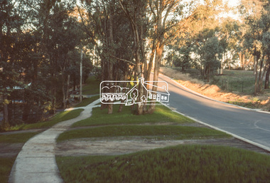
Slide, Frank Street, Eltham, May 1983
One of a series of images of roads and infrastructure taken by Eltham Shire Council Planning and Engineering officers, May 1983 specifically looking at Private Street Schemes post road construction/sealing operations35 mm colour positive transparency (1 of 21) Mount - Kodak Kodachrome Cardroads, infrastructure, road sealing, footpaths and gutters, private street scheme, eltham, frank street -
 Eltham District Historical Society Inc
Slide, Beard Street, Eltham, May 1983
One of a series of images of roads and infrastructure taken by Eltham Shire Council Planning and Engineering officers, May 1983 specifically looking at Private Street Schemes post road construction/sealing operations35 mm colour positive transparency (1 of 21) Mount - Kodak Kodachrome Cardroads, infrastructure, road sealing, footpaths and gutters, private street scheme, eltham, beard street -
 Greensborough Historical Society
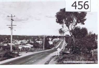
Photograph, Approach to Greensborough, 1947c
A vista of the top end of Greensborough in the late 1940's.Shows the development of Greensborough looking from the Melbourne approach side. Features the early power lines and post and wire fences along Grimshaw Street also dirt edges of the road, early street lighting and no footpaths.A black and white photograph of the approach to Greensborough in the late 1940's.Written in pen on back of photo: "Looking down Grimshaw St from the cutting near William St and Adeline Sts."greensborough, grimshaw street, post war era -
 Eltham District Historical Society Inc
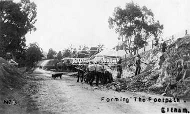
Photograph, Tom Prior, Forming the footpath, Eltham, c.1906
Photo: Tom Prior (brother of Mrs Ernest Richard Reynolds) using his home-made camera. Shows Richard Reynolds' cart and horses (Old Mac and Punch) and the Reynolds' dog. Gahan house on left. Bakery on right at corner of York Street. This image was used in August 1971 issue of Australian Municipal JournalThis photo forms part of a collection of photographs gathered by the Shire of Eltham for their centenary project book,"Pioneers and Painters: 100 years of the Shire of Eltham" by Alan Marshall (1971). The collection of over 500 images is held in partnership between Eltham District Historical Society and Yarra Plenty Regional Library (Eltham Library) and is now formally known as the 'The Shire of Eltham Pioneers Photograph Collection.' It is significant in being the first community sourced collection representing the places and people of the Shire's first one hundred years. The Reynolds family were early settlers in Research. The Reynolds/ Prior collection of photographs were taken by Tom Prior, the maternal uncle of Ivy Reynolds, around 1900 and the 60 photos in the album give a fine overview of many of the landmarks of Research and Eltham over 100 years ago. lvy lived in the family home for many years at 106 Thompson Cres Research. Ivy's father, Ernst Richard Reynolds and grandfather, Richard Reynolds, lived at the same address. Ivy's father Richard worked for Mr. Trail on his property in Research. Reynolds Road is named after the family. Mr Tom Prior (wife Eva) worked at the Melbourne zoo. He was very innovative and made his own camera, using the black cloth hood to exclude the light. The photographs are a reminder of the rural nature of Research and Eltham and its rich heritage.Digital image (4 x 4 inch B&W neg copy missing)shire of eltham pioneers photograph collection, eltham, main road, australian municipal journal august 1971, dudley street, gahan house, maria street, old mac (horse), punch (horse), reynolds prior collection, richard reynolds, road construction, york street -
 Eltham District Historical Society Inc
Photograph, Footpath tripping hazards, Shire of Eltham review
... footpaths ...Roll of 35mm colour negative film, 3 stripsKodak GA 100 5095shire of eltham, roads, footpaths -
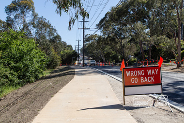 Eltham District Historical Society Inc
Photograph, Peter Pidgeon, Looking north from near Baxter street showing new wide footpath, Bolton Street upgrade, Eltham, 13 November, 2017, 13/11/2017
North bound lane closure. Born Digitalbolton street, bolton street upgrade, eltham, streets, baxter street -
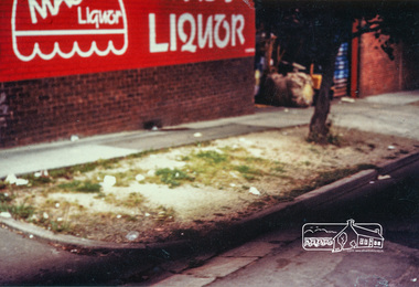 Eltham District Historical Society Inc
Photograph, Footpath and nature strip outside Mac's Liquor in Pryor Street, Eltham prior to upgrade works, c.1985, 1985c
Colour photographinfrastructure, mac's liquor, pryor street, shire of eltham -
 Glen Eira Historical Society
Document - Memorials in Glen Eira
... Footpaths ...This file contains one item: 1/A printout from the Victorian Memorials Database, undated and researcher unknown, containing records of 9 memorials in the Caulfield City municipality. These memorials are: - Caulfield Grammar School Site Pavement Marker, Elsternwick - Monument to racehorse ‘Jackstaff’ in Caulfield Racing Museum. - Rosstown Railway Marker, Bambra Road, Caulfield. - Thomas Alexander Browne Grave, Brighton Cemetery. - Grave of Sir John and Lady Monash, Brighton Cemetery. - Frederick Jowett Memorial Drinking Fountain, Caulfield Town Hall - Adam Lindsay Gordon Grave, Brighton Cemetery. - Jewish victims of World War 2 Memorial, Kadimah Centre, Elsternwick. - Hopetown Gardens Cannon, Elsternwick.historical markers, caulfield city, caulfield grammar school, elsternwick, regent street, caulfield racing museum, rosstown railway marker, caulfield, bambra road, curraweena road, marara road, city of caulfield, mayors, councillors, caulfield historical society, rosstown railway, caulfield grammar school pavement marker, monument to racehorse ‘jackstaff’, ross murray, browne thomas alexander, thomas alexander browne grave, brighton cemetery, rolf boldrewood, north road, caulfield south, browne margaret maria, grave of sir john and lady monash, monash john sir, monash hannah victoria lady, frederick jowett memorial drinking fountain, caulfield town hall, hawthorn road, glen eira road, jowett frederick, borough of caulfield, adam lindsay gordon grave, gordon adam lindsay, gordon annie lindsay, jewish victims of world war 2 memorial, kadimah jewish cultural centre and library, selwyn street, burston seddon, hopetoun gardens cannon, glenhuntly road, glen huntly road, schools, historic sites, plaques, footpaths, horseracing, horses, jackstaff, monuments and memorials, railways, authors, cemeteries, graves, gravestones, jewish community, town clerks, shire secretaries, town hall, drinking taps, poetry, children, libraries, world war 1939 – 1945, hopetoun, cannons, festivals and celebrations -
 Federation University Historical Collection
Book, Ballarat Conservation Guidelines, 1981, 1981
... footpaths ...The Guidelines were commissioned by the City of Ballarat , Historical Buildings Preservation Council and the Australian Heritage Commission.Cream soft coloured book of 60 pages. Contents include - Contributary Commercial Buildings, New COmmercial Buildings, Contributary residential Buildings, New Residential Development, Public and In stitutiona Buildings, Railways, Cemeteries, Botanic Gardens, Lake Wendouree, Public Open Spaces, Street Works, Fences and Landscaping, Advertising Guidelines, Lydiard/Camp Street Precinct Case Studyballarat, conservation guidelines, lydiard/camp street precinct case study, railway, botanic gardens, guttes, footpaths, signs, signage, fences, robin nuttall, gerald jenzen, ray tonkin, conservation study, architectural styles, verandahs, shopfronts, cast iron, wndy jacobs, miles lewis, gary vines, heritage planning, heritage guidelines -
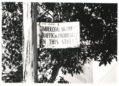 Port Melbourne Historical & Preservation Society
Photograph - Prohibited goods sign, Ross Street, Port Melbourne, Glen Stuart
Sign on lamp post in Ross Street - "Timber, coal, briquette traffic is prohibited in this street", also information re sign (Digital image on database)engineering - roads streets lanes and footpaths, ross street -
Port Melbourne Historical & Preservation Society
Plan - Cutting and filling, Ingles Street from Station Place to Crockford Street, 1860 - 1874
Plan for cutting and filling re Ingles St, and cross streets Station Place to Crockford St."Borough Surveyor's Office Sandridge" upper right hand corner on face.engineering - roads streets lanes and footpaths -
Port Melbourne Historical & Preservation Society
Plan - Street levels, c. 1862
Drawn up to replace rescinded portions of street plan of March 1862.Plan of street levelsDetails and signatures as belowengineering - roads streets lanes and footpaths, frederick william bull, thomas swallow, edward clark, town clerks -
Port Melbourne Historical & Preservation Society
Plan - Pickles Street, Town of Emerald Hill and Borough of Sandridge, Sep 1881
Town of Emerald Hill and Borough of Sandridge plan for Pickles Street, including transverse and longitudinal sections - Spring to Graham. NB "bridge" near Liardet Street.Signed by Charles Clayengineering - roads streets lanes and footpaths, charles clay -
Port Melbourne Historical & Preservation Society
Photograph - Council workers, Kenny Hall and Robin Donchi Snr, Port Melbourne, 1980s
Probably taken in the 1980sKenny Hall and Robin Donchi Senior near Liardet and Pickles Streets digging test holes for a tunnel under Cruickshank Street.engineering - roads streets lanes and footpaths, robin donchi snr, ken hall -
Port Melbourne Historical & Preservation Society
Photograph - Steve Johnson at south end of Clark Street, Port Melbourne, showing Commonwealth Government Engine Works in the background, 1980 - 1989
Probably taken in the 1980sPhotograph of Steve Johnson at south end of Clark Street Port Melbourne, showing Commonwealth Government Engine Works in the background.engineering - roads streets lanes and footpaths, built environment, robin donchi, commonwealth engine works, steve johnson -
Port Melbourne Historical & Preservation Society
Photograph - Liardet Street looking towards Pickles Street, Port Melbourne, 1980s
Probably taken in the 1980sPhotograph of Liardet Street looking towards Pickle Streetengineering - roads streets lanes and footpaths, built environment, robin donchi -
 Port Melbourne Historical & Preservation Society
Photograph - Council workers, Williamstown Road, Port Melbourne
Black and white photocopies of the Earle family (not related to Earl hardware) Council workers in Williamstown road, Port Melbourne circa 1923. First gentleman with arms crossed, back row is Walter Reynold Earlebuilt environment, engineering - roads streets lanes and footpaths, local government - city of port melbourne, walter reynold earle -
Port Melbourne Historical & Preservation Society
Photograph - Earle family portrait
Black and white photocopies of the Earle family (not related to Earl hardware) Family portrait, boy in wicker chair is William Earle; Older woman is Margaret Diaper; younger woman with child on lap is Ellen Kate Earle. One of the twins is Reg Earle, the other twin died of summer diarrhoea; young girl on right is Ivy. No other names known.built environment, engineering - roads streets lanes and footpaths, local government - city of port melbourne, walter reynold earle, william (bill) earle, reg 'ox' earle, ellen kate earle, ivy earle, lawrence earle, doris earle, lorna earle, ray earle, margaret heriot diaper -
Port Melbourne Historical & Preservation Society
Photograph - Earle kids
Black and white photocopies of the Earle family (not related to Earl hardware) Earle kids, circa 1927, Bill with hands on Lawrie's shoulders, Tall boy is Ray, then Doris and Reggie, with little Lorna in the front.built environment, engineering - roads streets lanes and footpaths, local government - city of port melbourne, walter reynold earle, william (bill) earle, reg 'ox' earle, ellen kate earle, ivy earle, lawrence earle, doris earle, lorna earle, ray earle, margaret heriot diaper -
Port Melbourne Historical & Preservation Society
Newspaper - Articles re burst water main in Liardet Street, Port Melbourne, 17 Dec 2014
In the early hours of Tuesday 16 December, 2014 a water main burst in Liardet St. The resulting sink-hole swallowed two cars and left a massive hole which took 8 days to repair and re-open the road. Several houses on the city side of Liardet St suffered water damage and water also entered the underground car park of the apartment block on the beach side.Newspaper clipping from "the Age" Wednesday, December 17, 2014. Also from Glen Eira /Port Phillip Leader, Tueday December 23 2014built environment - domestic, engineering - roads streets lanes and footpaths, engineering - canals and drainage, liardet street, water supply -
Port Melbourne Historical & Preservation Society
Document - CD-ROM, Archive Digital Books Australia, Melbourne & Suburbs Street Directory 1936, 2011
"Melbourne & Suburbs Street Directory 1936" Plastic CD case with white and pale green insert. Policeman image and motorcar.Melbourne & Suburbs Street Directory 1936. Collinsengineering - roads streets lanes and footpaths, 1936, street directory -
Port Melbourne Historical & Preservation Society
Sign - Farrell St West, c. 1980
Originally on side wall of house of Ruby Mary Blair. House on corner Evans and Farrell Streets. Removed from house circa 1980Oblong blue sign with "Farrell St : West " in white letteringFarrell St : Westbuilt environment - street furniture, engineering - roads streets lanes and footpaths, ruby mary blair, farrell street -
Port Melbourne Historical & Preservation Society
Photograph - Alterations to Bay Street (one lane each way), Port Melbourne, Ron Laing, 1999 - 2000
Part of Ron Laing's collection of photographs recording Port Melbourne over a thirteen year period. Donated to the PMH&PS by the photographer.A set of nine colour photographs covering the alterations of Bay Street to a one lane each way street, 1999-2000engineering - roads streets lanes and footpaths, ron laing, bay street -
Port Melbourne Historical & Preservation Society
Book, Lurking in Lanes, 1998
'Lurking in Lanes: a back fence history of the Lanes and Little Streets of Port Phillip', exhibition curated by the City of Port Phillip 1998'Lurking in Lanes: a back fence history of the Lanes and Little Streets of Port Phillip', a catalogue accompanying the exhibition curated by the City of Port Phillip 30pp, 1998engineering - roads streets lanes and footpaths, built environment - civic, domestic life, business and traders, built environment - domestic, glen cosham, janice c morton macdonald, glen stuart -
Port Melbourne Historical & Preservation Society
Photograph - Walkthrough lane between Princes and Station Streets, Port Melbourne, Pat Grainger, 1998
Taken and annotated by Pat Grainger for the "Lurking in the Lanes" book project and finally donated to the PMH&P Society in 1998Four original colour photographs of walkthrough lane between Princes and Station Streets (one lead-off at Liardet with two into Station Street)built environment - domestic, engineering - roads streets lanes and footpaths -
Port Melbourne Historical & Preservation Society
Book - Port Melbourne Council records, Engineering Department, Town of Port Melbourne?, Stone Breakers, 1894 - 1909
One of two Port Melbourne municipal record books giving details of stone metal contracts and measurements 1909-1924 in columns headed dept/Breaker's name/Sub account/Dat/Balance after deducting sub. A remarks column sometimes shows where stone was used. Title 'Measurement Book' is on spine. The pages in Vol. 1 are printed at the top 'Town of Port Melbourne - Account of Metal Measurements"Label 'Stone Breakers' on front coverengineering - roads streets lanes and footpaths, local government - town of port melbourne -
Port Melbourne Historical & Preservation Society
Book - Port Melbourne Council records, Engineering Department, Town of Port Melbourne?, Measurement Book, 1909 - 1924
One of two Port Melbourne municipal record books giving details of stone metal contracts and measurements 1909-1924 in columns headed dept/Breaker's name/Sub account/Dat/Balance after deducting sub. A remarks column sometimes shows where stone was used. Title 'Measurement Book' is on spine.Title 'Measurement Book' is on spine.engineering - roads streets lanes and footpaths, local government - town of port melbourne, local government - city of port melbourne