Showing 946 items
matching angles
-
 National Vietnam Veterans Museum (NVVM)
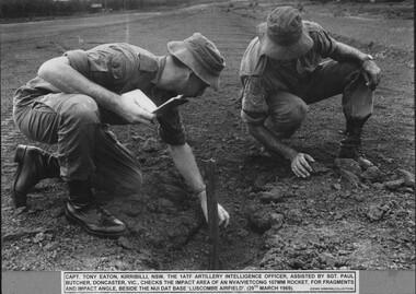
Photograph, Checking Impact Area 5
A black and white photograph of Capt Tony Eaton, Kirribilli, NSW, the 1st ATF Artillery Intelligence Officer assisted by Sgt Paul Butcher, Doncaster, Vic, checks the impact area of a NVA/VietCong 107mm rocket for fragments and impact angle, beside the Nui Dat Base, Luscombe Airfield (29th March 1969)photograph, capt tony eaton, sgt paul butcher, 1 atf base, artillery intelligence officer, nva/vc, 107mm rocket, nui dat base, luscombe airfield, gibbons collection catalogue -
 Stawell Historical Society Inc
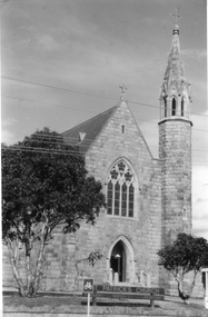
Photograph, St. Patrick’s Catholic Church c 1965-1970
Views of St. Patrick’s Catholic Church. Two of the photos are identical showing the parish hall on left of photo and a small part of priest's residence on right. A car can be seen parked below the church fence. Photo recorded to be taken by Ruby Willy Estate. The other photo shows a different view with a timber sign out the front of the church and two trees either side of the sign. This third photo also just shows the priests house on the right and taken around 1965 -1970.Three black and white photos of St Patrick's Church. Two are identical showing parish Hall on left of photo and small part of priest's residence on right. The other photo of the church taken at a different angle shows two trees and a church sign out the front. Electricity lines can be seen across the photo.stawell -
 Kew Historical Society Inc
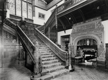
Photograph - Staircase of 'Tara Hall', Studley Park Road, Marc Strizic (attrib), c.1960
'Lost Glories: a memorial to forgotten Australian buildings' was published by David Latta in 1986. It tells the story of a number of significant Australian buildings that had previously been demolished. A chapter in the book was devoted to Goathland, later known as Tara Hall. To supplement the text, he sourced photographs from a range of suppliers, chiefly the Royal Women's Hospital which had once owned Tara Hall, but had sold it in 1960. This is one of the photographs donated to KHS by the author. The Staircase at Tara Hall, circa 1957. An angled view of the main hallway and staircase of Tara Hall (previously named Byram, Goathland and Lowan). To the right of the staircase in this Studley Park Road mansion, a large inglenook fireplace was located, which was surrounded by stucco decoration. The latter was a characteristic of E. G. Kilburn’s late style.Typed inscription on reverse: "The Staircase at Tara Hall. Above the ornate fireplace is the legend 'Come When You Mind, A Welcome Find'. (Royal Women's Hospital, Melbourne)." byram, goathland, tara hall, lowan, studley park (kew), george ramsden, sir malcolm mceacharn, edward george kilburn (architect), studley park road (kew) -
 Stawell Historical Society Inc
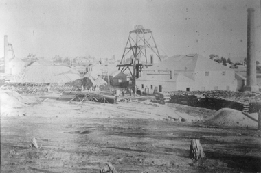
Photograph, North Cross Reef Mine & Mining Scene 1870 -- B/W Photo & Coloured Painting
Mining Scene - North Cross Reef Co.B/W North Cross Reef with buildings, poppet heads, Tailings and wood stack with people. Two colour prints of North cross Reef. One at a different angle to B/W. Second taken further back with wood stacks, tailing dam fenced in beyond poppet heads buildings chimmney's smoking. stawell -
 Orbost & District Historical Society
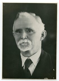
black and white photograph, C1877
This is a photograph of Mr Harry Felix . Richardson who selected land at Bete Bolong in 1887. He married Elizabeth Wardle in 1893 and had no children. Harry Richardson was a keen angler, rifle shooter and cricketer and was very much involved with the local community. With his brother, Alan, he had pioneered the move to the Snowy in 1878. He died in Bairnsdale , aged 83, in 1941.Harry Richardson was a prominent and active member of the Orbost community in the late 19th and early 20th centuries.A black / white portrait photograph of a man with wavy hair, a small white beard and moustache. -
 Bendigo Military Museum
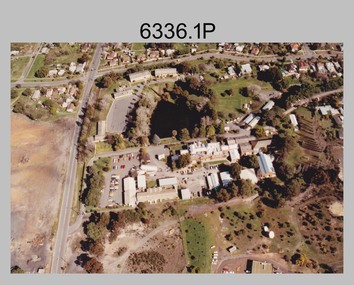
Photograph - Army Survey Regiment aerial photos, Fortuna, Bendigo, c1990
This is a set of two aerial photographs of the Army Survey Regiment, Fortuna, Bendigo taken in c1990. These photos are indicative of a series of 23 aerial photos in the collection taken from multiple angles and elevations. It is possible the photographs were taken from a hot air balloon. The approximate date of the photos is based on the existence of the new printing building - Wazgoose Hall and the new records building.This is a set of two aerial photographs of the Army Survey Regiment, Fortuna, Bendigo taken circa 1990. Colour photographs are on photographic paper and scanned at 300 dpi. They are part of the Army Survey Regiment’s Collection. .1) to .2) - Photo, colour, c1990. Army Survey Regiment aerial photos.royal australian survey corps, rasvy, army survey regiment, army svy regt, fortuna, asr -
 Kiewa Valley Historical Society
Four photographs of the Blue Duck Hotel and two Photos of the Glen Wills area, c1920 Post cards, c1949/50 small photographs
The Blue Duck Hotel stands at the confluence of 3 trout rivers - Cobungra, Bundarra and Mitta Mitta, called Angler's Rest. The original 1900's building was of slab construction and operated as a butcher shop, servicing miners on the track from Omeo to Mt. Wills. In 1912 it was purchased by a miner, Billy O'Connell, and he obtained a hotel license. In the early 1920's he transported 2 houses from Omeo on Horse drays. One is the main building of the Blue Duck and the other was a residence where Billy and his wife raised their nine children. The small log structure behind the pub is State School No.4286 where the children attended school. A teacher was shared with Glen Wills. By the late 1920's the hotel was discovered and patronized by keen anglers. Sir Harold Clapp (head of the railways) was one and he had the bronze blue duck cast and presented to the owners in the 1930's. This stands at the entrance to the premises.These photographs are of a building, in a remote area, that has provided a service to miners, anglers and travellers for over 100 years and continues to do so today. It also played a vital role in the history of the Mt. Wills/Omeo gold mining days.3 Post cards, Black and White photographs. 3 small black and white photographsPost Card No. 1 - "Blue Duck Hotel- Omeo-Glen wills road Ray Love Series No.2"(written on lower front) Post Card No. 2- "Looking towards Bogong High Plains. Omeo-Glen Wills road"(front, bottom, L hand) Ray Love Series No. 18 (front, lower R hand corner) On both of above photos, centre back, is stamped POST CARD and underneath this is printed "A GENUINE PHOTOGRAPH'/ Post Card No. 3 - Bottom L hand corner "Mystic Sea Australian Alps". R hand corner "(Bulmer Copyright)". Each small photograph, handwritten on back "Blue duck Hotel". All have circular stamp with "Print by Wilson White Albury" blue duck hotel; anglers rest; omeo highway; fishing; mining -
 Melbourne Tram Museum
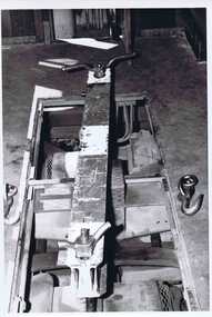
Photograph - Set of 4 Black & White Photograph/s, Melbourne & Metropolitan Tramways Board (MMTB), Early 1970's?
Set of four Black and White photograph of recovery equipment for tramcars. Two prints of each except - .4 .1 - steel beam shown in position in the saloon portion of a tram used to secure a bogie to the body of tram with steel section over transom and showing lifting hooks and securing or lifting bolts. Shown in position where the tramcar body floor was above that of the tramcar transom. .2 - ditto, but on an angle in a wide body tram where the top of the transom matched the top of the floor. The bogies are on an angle. .3 - brackets in position for securing the body spring on the truck fitted to tram 980 to the body of the tram. .4 - brackets shown stored inside the cabin of the tram. Mid 1970's? Photographer likely MMTBtrams, tramways, recovery, accidents, tramcars, sw6 class, pcc class, w2 class, tram 980, st. louis b3 -
 Eltham District Historical Society Inc
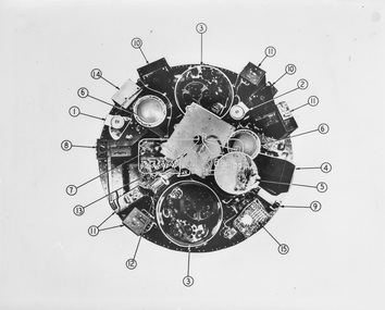
Photograph - Black and White Print, NASA, Tiros II - Taken from above with cover removed, 1960
On reverse: Tiros II - Taken from above with cover removed: 1. Wide angle TV camera 2. Narrow angle TV camera 3. TV tape recorders 4. Infra red - 5 channel radiometer 5. Infra red electronics 6. Electronic operations sequence timing 7. Relays for magnetic stabilisation for altitude 8. Control box for electronics 9. Infra red horizon scanner 10. Electronic camera circuits 11. Electronic TV tape circuits 12. Telemetry switches 13. Antenna diplexer (covering storage batteries) 14. Automatic signal generator 15. Fuse board and current regulatoralan gardiner collection, space industry, 1960, satellite, tiros ii -
 Glenelg Shire Council Cultural Collection
Tool - Ships Plans / Moulds, n.d
Wooden pattern for mould for boat fitting. Rectangular, one curved long edge, one straight. Two buttress shaped 'legs' attached to underside, reaching from shaped to straight side, then extending at right angles. Two small cylidners of differing diameters, attached to underside, one a top the other. Painted yellow/orange. -
 Orbost & District Historical Society
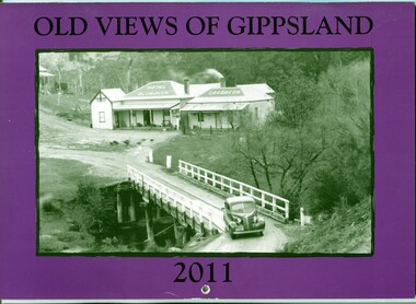
calendar, Old Views of Gippsland 2011, 2010
This is one of a series of calendars published annually by East Gippsland Historical Society.This item is a useful reference tool.A 2011 stapled calendar, titled "Old Views of Gippsland". On the purple coloured front is a black/white photograph of The Blue Duck Hotel at Angler's Rest on the road to Glenn Wills C/1940. It contains early photographs of East Gippsland, one for each month. There is a hole for hanging. The title is at the top and the year at the bottom in black print. calendar-old-views-of-gippsland photographs-historic-gippsland -
 Mont De Lancey
Decorative object - Glassware
A small rectangular Windsor patterned clear glass container for a dressing table, possibly used for hairpins in the 1930's or 40's. It has 4 angled pieces that protrude from each bottom corner. Three rows of hexagonal shapes are part of the pattern on all sides. There are chips and cracks. It may have had a lid.Hexagonal cuts to the pattern on all sides of the container.glassware, domestic object -
 Melbourne Tram Museum
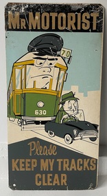
Sign - "Mr Motorist Please keep my tracks clear"
Used by the MMTB in an attempt to keep tram tracks clear of motor cars. It seldom worked. Signs would have been fixed to the ends of a tram so it could be seen by motorists. See Item 6087 for another version.Demonstrates the methods the MMTB to ask motorists to keep tram tracks clear during the 1950's and 1960's. The cartoon character and wording is perhaps a later attempt to get some attention.Sign - Zincalume steel sheet, with four holes in angled or trimmed corners asking "Mr Motorist Please keep my tracks clear", The sign features an cartoon image of an angry tram (W2 630 on route 70) and a rather sleepy looking motorist driving a car on the tram tracks. The letters are in a raised paint finish.tram stop, signs, mmtb, tram 630, route 70, w2 class, tramways, trams, traffic control -
 Flagstaff Hill Maritime Museum and Village
Octant, Mid to late 19th Century
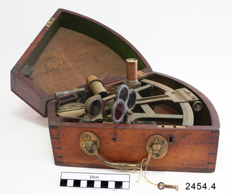
An octant is an astronomical instrument used in measuring the angles of heavenly bodies such as the sun, moon and stars at sea in relation to the horizon. This measurement could then be used to calculate the altitude of the body measured, and then the latitude at sea could also be calculated. The angle of the arms of an octant is 45 degrees, or 1/8 of a circle, which gives the instrument its name. Two men independently developed the octant around 1730: John Hadley (1682–1744), an English mathematician, and Thomas Godfrey (1704–1749), a glazier in Philadelphia. While both have a legitimate and equal claim to the invention, Hadley generally gets the greater share of the credit. This reflects the central role that London and the Royal Society played in the history of scientific instruments in the eighteenth and nineteenth century's. There were also two others who are attributed to having created octanes during this period, Caleb Smith, an English insurance broker with a strong interest in astronomy (in 1734), and Jean-Paul Fouchy, a mathematics professor and astronomer in France (in 1732) In 1767 the first edition of the Nautical Almanac tabulated lunar distances, enabling navigators to find the current time from the angle between the sun and the moon. This angle is sometimes larger than 90°, and thus not possible to measure with an octant. For that reason, Admiral John Campbell, who conducted shipboard experiments with the lunar distance method, suggested a larger instrument and the sextant was developed. From that time onward, the sextant was the instrument that experienced significant development and improvements and was the instrument of choice for naval navigators. The octant continued to be produced well into the 19th century, though it was generally a less accurate and less expensive instrument. The lower price of the octant, including versions without a telescope, made it a practical instrument for ships in the merchant and fishing fleets. One common practice among navigators up to the late nineteenth century was to use both a sextant and an octant. The sextant was used with great care and only for lunar sightings while the octant was used for routine meridional altitude measurements of the sun every day. This protected the very accurate and pricier sextant while using the more affordable octant for general use where it performs well. The invention of the octant was a significant step in providing accuracy of a sailors latitude position at sea and his vessels distance from land when taking sightings of land-based landmarks.Octant with metal handle, three different colored shades are attached, in wooden wedge-shaped box lined with green felt. Key is attached. Two telescope eyepieces are in box. Some parts are missing. Oval ink stamp inside lid of box, scale is graduated to 45 degrees. Ink stamp inside lid of box "SHIPLOVERS SOCIETY OF VICTORIA. LIBRARY"instrument, flagstaff hill, warrnambool, shipwrecked coast, flagstaff hill maritime museum, maritime museum, shipwreck coast, flagstaff hill maritime village, great ocean road, octant, navigation, nautical instrument, navigation instrument, john hadley, sextant, astronomical instrument -
 Mission to Seafarers Victoria
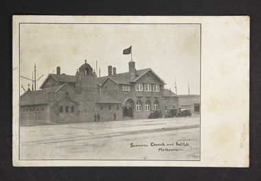
Postcard - Postcard, Sepia, The Australasian, Seamen's Church and Institute Melbourne, September 1917
This photograph taken by the Australasian, depicts the central Institute in September 1917. It was published on the 15th of September 1917 along with other photographs taken during the dedication of the St Peter chapel on the 6th of September. The photograph was also used in a Jottings mentioning "Courtesy of the Australasian".This is one of the first photographs of the Mission's building opened in 1917 before the Norla Dome was erected in 1920. Black and white postcard with a photograph taken at a 45 degree-angle showing the front of the mission in Flinders Street probably in 1917. Three men are standing in front of the church and three cars are parked in front of the mission. The Flying Angel flag. Behind the mission we can see the masts probably from ships berthed on the Australian wharf.Right bottom corner: Seamens Church and Institute, Melbourneflinders street, melbourne, central institute, walter richmond butler, men, cars, sailors, seamen, mission to seamen, seamen's mission, mission to seafarers, flying angel flag, australian wharf, ships, australasian, 1917 -
 Kiewa Valley Historical Society
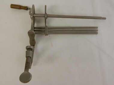
Bandage Winder - Medical
This medical / hospital instrument was used in the Tawonga District General Hospital which was built in the 1950's specifically for the increase in population due to the Kiewa Hydro Scheme.Historical: Shows the development of scientific hospital equipment. Provenance: Used in the Tawonga District General Hospital which was remote and therefore required good equipment. Good condition and good interpretation capacity.Steel vice with 5 rods at right angles to the bottom plates and a handle on the opposite side attached to the square shaped rod. The handle is covered with a wooden hand piece enabling this square shaped rod to be rotated for winding bandages. The other 4 rods are cylindrical. The handle of the vice can be screwed down to fit onto a table or bench.Handle of the vice: '2697'bandage winder, medical, hospital, tawonga district hospital -
 Kiewa Valley Historical Society
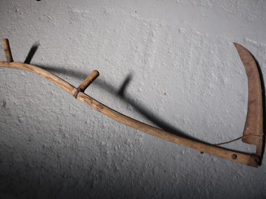
Scythe
Used as an agricultural hand tool for mowing grass or harvesting crops. It is historically used to cut down or reap edible grains, before the process of threshing. Replaced by horse drawn and then tractor machinery. Used by the early farmers in the Kiewa Valley.The steel blade is curved with a pointy end. It is attached to a long, slim wooden shaft with a slight S curve. It has 2 handles, one about half way along the shaft and another near the top both at right angles to the shaft. This results in the handles being on slightly different planes and makes it comfortable for the user when working. scythe, hand tool, mowing, harvesting -
 Whitehorse Historical Society Inc.
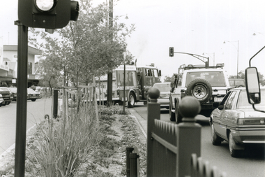
Photograph, Whitehorse Road Mitcham on a Sunday, 2000
Produced as one of a series of 24 prints commissioned by Nunawading & District Historical Society -|Theme: Intersections of Mitcham and Nunawading 2000/2001.|See also Series by P. Simmenauer on the same theme.Black and white photograph - print and negative looking along Whitehorse service Road in Mitcham on a Sunday afternoon - note heavy traffic. Landscaped median strip mainly Australian natives - also angle parking in service road. Vehicles in view: Metropolitan Fire Brigade, tender No. 27; Sedan; 4 wheel drive car; Mitsubishi Sedan.metropolitan fire brigade - tender 27, whitehorse road, mitcham, service roads -
 Surrey Hills Historical Society Collection
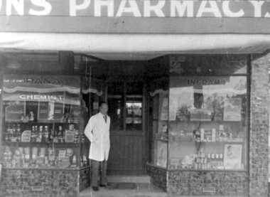
Photograph - Photograph (Copy), Charles Leslie Mitton's Surrey Hills pharmacy, c1933
REF: SHNN article Oct/Nov 1991: Pharmacy was purchased from Mr Nye by C L Mitton in 1933; later moved to 139 Union Road. Research: Stanley Morris Nye (born Ballarat in 1889, son of a Methodist minister; served AIF in WW1) moved to Surrey Hills from Auburn after 1922. He was the first occupant of 131 Union Road which was built in 1924. He is listed in the 1924,1927 and 1931 electoral rolls at 86 Canterbury Road, Surrey Hills. He died aged 44 years in December 1933 and Charles Leslie Mitton took over the business. Charles Leslie Mitton was practising in Newmarket prior to taking over the pharmacy in 1933, the year he also married Ethel Sylvia Stevenson. They lived at 65 Union Road until c1940 when they moved to Kenmare Street, Box Hill North. The pharmacy passed to his son John and daughter Rosalind Lorraine (1937-1997)Black & white photo of a man in a white coat, identified as Charles Leslie Mitton, standing outside his pharmacy in Union Road, Surrey Hills. There is a step up to a central door with glass panels in the top half. The display windows are angled to either side of the door. Within these are shelves displaying many products. The surrounds of the windows are tiled.Note sign for Ipana toothpaste.mitton's pharmacy, businesses, pharmacies, pharmacists, union road shops, mr charles leslie mitton, mr stanley morris nye -
 Surrey Hills Historical Society Collection
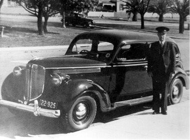
Photograph, Fred Lyons, taxi driver of Surrey Hills
This is one of a series of photos donated by Arthur Lyons. From 1907 a cab service operated from near the railway gates in Union Road. It was established and maintained by Mr C Fraser until c1916. George Rea either took over then or set up in opposition; he retired in 1945. Fred Lyons initially worked for George until he set up his own business. In time he changed over to a motor vehicle and continued his service until 1960. Frederick Adolphus Lyons (1891-1980) was born in Surrey Hills, son of Thomas and Catherine Lyons. He married Elizabeth Ruby Hall in 1918. They lived just around the corner at 55 Sunbury Crescent. The Lyons’ home in Sunbury Crescent was called ‘Knopshambury’ - this was probably a misspelling of Knockshanbally in Co Kilkenny, the birth place of Fred’s father, Thomas Edmund Josias Lyons (1846-1915). Arthur Lyons was born in Surrey Hills on 12 Jun 1920. He became a motor mechanic / welder and lived at 55 Sunbury Crescent. The donation was made while he was in hospital. He died shortly afterwards (23 Sep 1990). Donation was finalised by a neighbour, Mrs Florence Ann Armitstead, wife of Glen Victor Armitstead. Glen was a local hairdresser. They moved to 11 Sunbury Crescent after their marriage in 1939. Arthur had no relatives to distribute the material to.Black and white photo of Fred Lyons dressed in suit and cap standing on the footpath beside his taxi. Behind the taxi is another car approaching from a street at right angles. There are wide stretches of grass planted with trees including palm trees. In the background are houses with picket fences; the most visible house is clearly Victorian in style. transport, businesses, taxis, fred lyons, frederick adolphus lyons, uniforms -
 Kilmore Historical Society
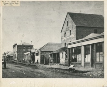
Photograph, SW Sydeny Street, 1860
25cm x 20 cm black and white photograph mounted on board. The photograph is taken at an angle so you can see multiple buildings on the western side of Sydney Street including: Trainor's Steam Flour Mill, Parnells Boot Shop, Quinn Solicitor, Youngs Bakery and Post Office and Royal Oak Hotel in the distance.Written on the back: #10 Trainor's Steam Flour Mill, Parnell's Bootshop, Quinn Solicitor, Young's Bakery + Post Office #3.#5.10/86-38A Copy of Sydney St. Kilmore 1860 Trainors Mill (opposite present Mill St) Royal Oak Hotel in distance.post office, flour mill, bakery, bootmaker -
 Lakes Entrance Historical Society
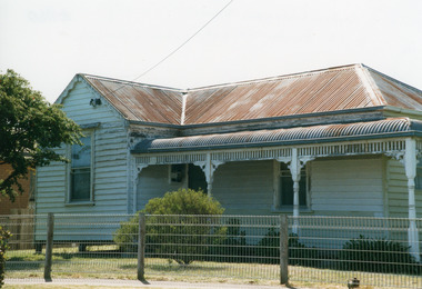
Photograph - Historic House, 1999
Building reputed to be part of Mrs Carstairs Boarding House at New Works, dismantled and transported to present site.Colour photograph of a timber dwelling at 12 Hunter Street. With hip roof across building, gable at right angles at western.front room. Iron roof, bull nose veranda. Simple timber fringe under veranda roof, timber brackets connect fringe to square veranda posts with lathed pattern in centre. Lakes Entrance Victoriahouses, heritage study -
 Flagstaff Hill Maritime Museum and Village
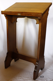
Furniture - Missal Lectern
The Missal lectern was part of the original furnishings of St Nicholas Seamen's Church, Williamstown, Victoria, and was donated by Mrs R J Eward for use in the religious services there. The church was operated by the Williamstown Missions to Seamen organisation. THE MISSIONS TO SEAMEN (Brief History): - The Missions to Seamen was an Anglican charity in Great Britain that has served the world's seafarers since 1856. Its symbol is a Flying Angel, inspired by a Bible verse. Today, there are centres in over 200 ports worldwide where seamen of all backgrounds are offered a warm welcome and provided with a wide range of facilities. In Victoria, the organisation began in Williamstown in 1857 as a Sailors’ Church, also known as ‘Bethel’ or the ‘Floating Church’ in an old hulk floating in Hobson’s Bay, Port of Melbourne. It soon became part of the Missions to Seamen, Victoria. In the year 2000, the organisation, now named Mission to Seafarers, still operated locally in Melbourne, Portland, Geelong and Hastings. The Ladies’ Harbour Lights Guild was formed in 1906 to support the Missions to Seamen in Melbourne and other centres, such as Williamstown. Two of the most significant ladies of the Guild were founder Ethel Augusta Godfrey and foundation member Alice Sibthorpe Tracy (who established a branch of the Guild in Warrnambool in 1920). The Guild continued its work until the 1960s. In 1943, a former Williamstown bank was purchased for the Missions to Seaman Club. The chapel was named St Nicholas’ Seamen’s Church and was supported by the Ladies’ Harbour Lights Guild, the Williamstown Lightkeepers’ Auxiliary and the League of Soldiers’ and Sailors’ Friends. It ceased operation in 1966. A Missions to Seamen Chapel and Recreation Room was a significant feature of ports during the late 1800s and into the 1900s. It seemed appropriate for Flagstaff Hill to include such a representation within the new Maritime Village, so the Melbourne Board of Management of Missions to Seamen Victoria gave its permission on 21st May 1979 for the entire furnishings of the Williamstown chapel to be transferred to Flagstaff Hill. The St Nicholas Seamen’s Church was officially opened on October 11, 1981, and closely resembles the Williamstown chapel. This Missal lectern is historically significant for its origin in the St Nicholas Mission to Seamen's Church in Williamstown, established in 1857 to cater for seafarers' physical, social, and spiritual needs. It originated in Bristol, England, when a Seamen's Mission was formed in 1837. It is also an example of a community-supported local charity organisation.Solid wooden Missal Lectern on two supporting legs. The top section has an angled back and a small shelf at the front, designed to support a bible. The two legs, with decorative feet, are supported by the decorative wooden bar. There appears to be a rectangular label in the centre front of the small shelf. This lectern is part of the St. Nicholas Seamen's Church Collection. flagstaff hill, warrnambool, shipwrecked coast, flagstaff hill maritime museum, maritime museum, shipwreck coast, flagstaff hill maritime village, great ocean road, religion, religious service, church furniture, religious furniture, lectern, preaching equipment, missal lectern, bible support, music stand -
 Orbost & District Historical Society
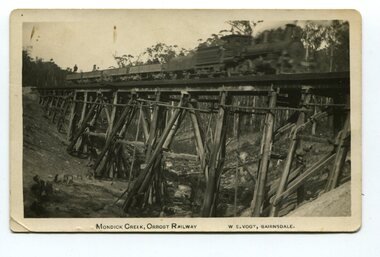
black and white photograph, Vogt. W.S, first half 20th century
This 97km Bairnsdale to Orbost extension through rugged terrain was reputed to have been the most difficult rail project undertaken in Victoria. This wooden bridge was one of the unique railway bridges of the East Gippsland Railway line. Mundic Creek Bridge is of unique design because the line crosses at a very sharp angle. This bridge like many others on the line have "disappeared". This one, probably because of a bushfire.The Bairnsdale to Orbost rail line contains the most varied range Of timber & timber composite bridges on any Victorian line. This photograph is a record of that. A black / white photograph of a train on a wooden railway bridge at Mundic Creek.on front - Mundic Creek, Orbost Railway W.S.Vogt, Bairnsdalemundic-creek-bridge east-gippsland-railway -
Clunes Museum
Tool - GOLD CRADLE & PANNING DISH, JAMES ESMOND, CIRCA 1850
USED TO OBTAIN ALLUVIAL GOLD THE DESIGN OF THIS EQUIPMENT IS MOSTLY BASED ON THE PRINCIPLE OF THE WAY HEAVY MINERALS ARE CONCENTRATED IN ALLUVIAL DEPOSITS. THE PROSPECTING DISH IS USED WHEN WORKING WITH SMALL AMOUNTS OF STONES & CLAY WHILE BIGGER JOBS THE CRADLE OR BANJO IS MORE EFFICIENT. THE GAUZE OF MESH IN THE SIEVE IS VARIABLE. THE CRADLE OR BANJO IS USUALLY SET UP AT RIGHT ANGLES TO A SHALLOW CREEK OR WATERHOLE WITH THE OPEN ENDS TOWARDS THE WATER.1 WOODEN CONSTRUCTION MADE BY HAND WITH GAUZE FILTER IN UPPER SECTION TO SEPARATE QUARTZ ROCKS, SAND AND SOIL. A HANDLE ON BOX LIKE CONSTRUCTION IS USED TO ROCK THE CRADLE WHICH IS MOUNTED WITH ITS ROCKERS RESTING ON WOODEN BEARERS. .2 PANlocal history, mining equipment, mining -
 Queenscliffe Maritime Museum
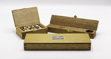
Equipment - Compass correctors, shadow pins and magnets
True North is at the centre of the north pole This is a fixed point at the top of the planet. The majority of our navigational charts are orientated so that they use true north as their reference point. This is because true north doesn’t move. Magnets don’t point towards true north however. They point toward magnetic north which is in a different geographical place. The difference in the angle between true north and magnetic north is call variation.Three wooden boxes containing magnetic compass quadrantal correctors, correcting magnets and shadow pins.Saura Keiki Seisakusho Co Ltdcompass, correcting magnets, magnetic variation -
 Melbourne Tram Museum
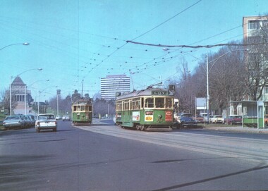
Postcard - St Kilda Road, with W class trams and the Shrine of Remembrance, National View by Murfett Publishing, 1970s
Postcard - St Kilda Road, view looking south at the Shrine of Remberance, BP House and on the far right part of the now demolished Prince Henry's Hospital. Trams in the view are W2 345 (Carnegie Route 4) and SW6 913 (City, Route 4). Tram 813 has adverts for Coffey Ford and T&G insurance along with others. The driver of 913 has his cap on an angle.Yields information about St Kilda Road around the Shrine, c1970 and tram services.Postcard colour - St Kilda Road, with W class trams and the Shrine of Remembrance - National View - Murfett publishingtrams, tramways, st kilda road, w2 class tram, sw6 class tram, tram 913, tram 345, shrine of remembrance -
 Bendigo Historical Society Inc.
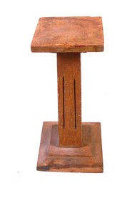
Decorative object - Display Pedestal
A wooden construction of three pieces. The lower piece is eleven centimetres square and two centimetres high, there's a one centimetre right angle edge then angled two centimetre long and rising one centimetre section, then there's half centimetre high and seven centimetre square flat section. The middle piece nineteen centimetres high and four centimetres square at the bottom tapering to three centimetres square at the top, each side has two eleven centimetre groves in it that start and finish four centimetres from each end. The upper piece is a smaller inverted copy of the lower piece, it has four centimetre square attached to the middle piece and an eight centimetre flat square on top. It has a clear coating applied to it which is deteriorating. woodwork, small display pedestal -
 Bendigo Historical Society Inc.
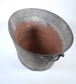
Domestic object - Wash Tub
Before hot and cold water was easily available children were bathed in small tubs. An oval metal wash tub. The base has a four centmetres metal band around it that extends two and a half centimetres below the bottom of the tub. The bottom of the tub is an oval 50 centimetres long and 40 centimeters wide. The wall is 29 centimetres high with rolled rim half a centimetre wide on the top, it's made in two pieces that are folded together at each end. The top of the tub is an oval 62 centimetres long and 49 centimetres wide. There are identical metal handles at the top of the tub at each end, they are made of a one centimetre diameter metal rode, they have a nine centimetres long grip, a four centimetre piece at right angles on each end and a two centimetre long piece at the opposite right angle on the end which is inserted into a two centimetre loop that's attached to the tub. wash tub, personal hygiene -
 Glen Eira Historical Society
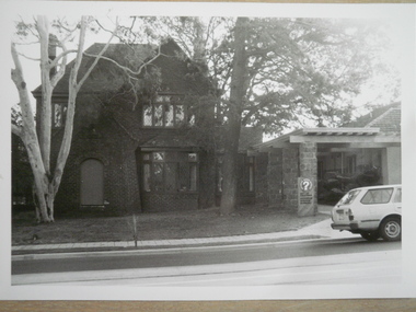
Photograph - Oaktree House, Hawthorn Road Caulfield
Seven black and white photographs of Oaktree House Caulfield also known as the Caulfield Citizens Advice Bureau date unknown. These photographs are of varying sizes the first five being 125mm x 90mm, the next one being 255mm x 205mm and the final one being 115mm x 85mm. These photographs are of the front of the house only taken from different angles with signage visible to identify the Bureau and its services.oak tree house, hawthorn road, caulfield, caulfield citizens advice bureau, brick houses, houses, photographs, pergolas, architectural features, architectural styles, citizens advice bureaus