Showing 15881 items
matching areas
-
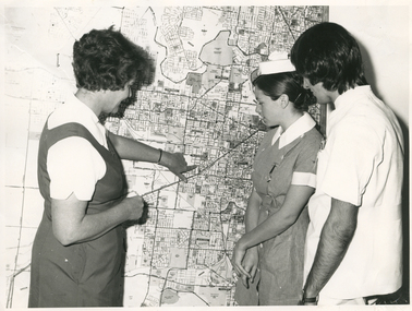 Royal District Nursing Service (now known as Bolton Clarke)
Photograph - Photograph, black and white, Barry Sutton, 01.05.1974
Sister Ellen Anderson is the Supervisor of the Royal District Nursing Service, (RDNS) Footscray Centre. She is wearing her RDNS uniform of a short sleeve white blouse under a royal blue V neck tunic style dress. Sr. Anderson is showing two Student nurses from Western General Hospital the map with the areas covered by Footscray Centre. The map had different colour pins to identify streets where patients lived who were currently receiving nursing care from RDNS Sisters working in these areas (districts).During their training, Student nurses from several hospitals either attended the Royal District Nursing Service (RDNS), Education Department, or, a RDNS Nurse Educator travelled to the appropriate hospital’s Education Department to educate the Trainees on District nursing through the RDNS Community Nursing Program. Following the lectures Students went to a RDNS Centre and each Student accompanied a Trained nurse (Sister) for a week observing and gaining knowledge of all facets of nursing care in the home. This gave them an insight into the home conditions and situations patients faced after discharge from hospital. During 1971 there were 584 Student nurses who received field experience with RDNS. From its inception as Melbourne District Nursing Society (MDNS), in 1885, their Trained nurses (Nurses) worked in specific areas, 'districts'. The first Nurse worked east and west, between Victoria Parade and Flinders Street and, north and south, between Spencer Street and Spring Street. When a second Nurse was employed they divided this area at Elizabeth Street so each Nurse could attend to patients in the same area giving continuity of care. As the Society expanded, becoming Melbourne District Nursing Service, then, with Royal patronage, Royal District Nursing Service (RDNS) many Centres were opened throughout the Melbourne Metropolitan area and outer suburbs. The District nurse's areas (districts) grew and were divided within Shire boundaries for e.g. Knox 1, Knox 2, Knox 3, Knox 4, within the area of the Shire of Knox. A map covering the Centre’s Districts was attached to a wall, and its different colour pins identified streets where patients lived who were currently receiving nursing care from the RDNS Trained nurses (Sisters) working in these areas (districts).On the left of this black and white photograph is Royal District Nursing Service (RDNS), Sister Ellen Anderson, who has short dark curly hair and is wearing her RDNS uniform of a short sleeve white blouse under a dark V neck tunic style frock. She is standing side-on, towards the right of the photograph, and with her left hand is pointing to an area on a large map attached to the wall in the background. To her right, is a Student nurse who is facing Sr. Anderson, and looking at the area on the map. Under her white nurses cap, she has her long dark hair drawn back, and is wearing her hospital uniform of a short sleeve checked dress with white collar and cuffs; a nursing watch is attached to its upper left; her hands are clasped in front of her. To her right, is a male Student nurse who has collar length straight dark hair, and is wearing white trousers and a short sleeve white top with pens in the left upper pocket. He is looking at the areas on the map.. Barry Sutton MA 77 informationroyal district nursing service, rdns, rdns education, rdns centre, rdns district map, sister ellen anderson -
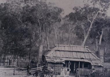 Halls Gap & Grampians Historical Society
Photograph - B/W, c 1870
Jane and Samuel Delley emigrated to Australia in 1857. By 1870 they and their young family had settled in the area at the entrance of the Fyans Valley and on the west of Fyans Creek. There they built a home and recognising the needs of passing travellers and timber-getters, they established Delley's Inn, providing food and refreshments to all in need.Timber dwelling with bark roof and two chimneys, one at either side of the house. In front stand four men and two women with two wagon drays in the foreground. The area is enclosed by picket fencing close to the house and a rough timber fence on the rear of the boundary. Delley's Inn,1870 on reverse in pencilbuildings, houses, accommodation, delley's inn -
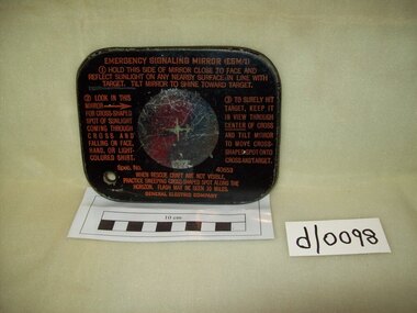 Waverley RSL Sub Branch
Signalling Mirror, General Electric Company
Mirror blackened on one side. 5cm.circular clear area in the centre. This circular area has a green cross in the middle. There is a 1 cm. hole in the lower left corner.Useage instructions are printed in amber on the face side. -
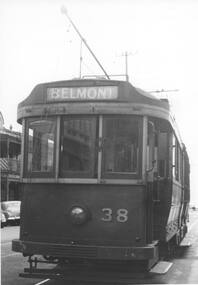 Ballarat Tramway Museum
Photograph - Black & White Photograph/s
Yields information about Geelong trams in the late 1940's and the bogie trams.Black and white print of Geelong 39. Tram has the destination of Belmont. Photo taken in the double track area in the city area. Photo not dated or identified on the rear.trams, tramways, geelong, city, tram 39 -
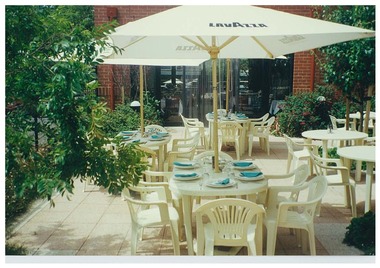 Queen Victoria Women's Centre
Photograph, c. 1998
Colour photograph. Courtyard on ground floor eastern side facing south into the cafe area and Lonsdale street. Outdoor seating area of the Cafe. Taken for the QMag Newsletterphotograph, outdoor furniture, cafe -
 Lakes Entrance Historical Society
Book, Land Conservation Council, Victoria, East Gippsland Area Review Final Recommendations Land Conservation, 1986
Report describing the physical nature of the East Gippsland area (Victoria) study area. History, climate, geomorphology, land use, flora and fauna are presented. Map included.topography, land settlement -
 Melbourne Tram Museum
Document - Report, Melbourne & Metropolitan Tramways Board (MMTB), 'Current trends which may indicate the future growth and nature of the metropolitan area and in particular the Central Business area of Melbourne", Jan. 1966
Report - Foolscap, card covers, red binding strip, about pages + drawings or charts, titled 'Current trends which may indicate the future growth and nature of the metropolitan area and in particular the Central Business area of Melbourne" Has three parts: 1 - Future growth of population of the Melbourne Metropolitan Area 2 - The Centre of Gravity of and general distribution of the Central Business area of Melbourne 3 - Future growth of the Central Business Area of Melbourne. Dated Jan 1966, prior to the construction of the Underground Railway and the move to Docklands.Has "JEC" in pencil on top right hand corner.trams, tramways, melbourne, planning, development -
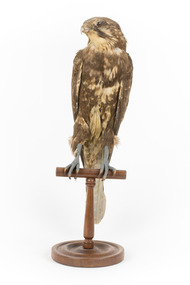 The Beechworth Burke Museum
Animal specimen - Brown Falcon, Trustees of the Australian Museum, 1860-1880
The Brown Falcon is a small to medium bird of prey which can be found all throughout Australia. These birds are raptors and typically feed on mammals, birds, snakes, insects and rabbits. The Brown Falcon are located in all but the densest forests. They typically prefer to reside in locations of open grassland and agricultural areas which have scattered trees or telephone poles which the bird can perch on. When frequenting towns located in the Australian Outback, these birds are reportedly quite tame and can be approached by humans. They may stay in the same location throughout the year or chose to move around locally in response to any changes in weather conditions. This specimen is part of a collection of almost 200 animal specimens that were originally acquired as skins from various institutions across Australia, including the Australian Museum in Sydney and the National Museum of Victoria (known as Museums Victoria since 1983), as well as individuals such as amateur anthropologist Reynell Eveleigh Johns between 1860-1880. These skins were then mounted by members of the Burke Museum Committee and put-on display in the formal space of the Museum’s original exhibition hall where they continue to be on display. This display of taxidermy mounts initially served to instruct visitors to the Burke Museum of the natural world around them, today it serves as an insight into the collecting habits of the 19th centuryThis specimen is part of a significant and rare taxidermy mount collection in the Burke Museum. This collection is scientifically and culturally important for reminding us of how science continues to shape our understanding of the modern world. They demonstrate a capacity to hold evidence of how Australia’s fauna history existed in the past and are potentially important for future environmental research. This collection continues to be on display in the Museum and has become a key part to interpreting the collecting habits of the 19th century.The Brown Falcon specimen has plumage which is mostly brown and intermixed with white. This provides the appearance of having spotted colouring on the birds back. The head is also mostly brown with white under the beak area and a characteristic brown streak under the eye area. The eye is made from dark coloured glass.3 / Brown Hawk / See Catalogue, page 2 / taxidermy mount, taxidermy, animalia, burke museum, beechworth, australian museum, skin, reynell eveleigh johns, bird, brown falcon, falconidae -
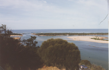 Lakes Entrance Historical Society
Photograph - The Entrance Lakes Entrance, LERHS, The Entrance Lakes Entrance viewed from Jemmys Point, 1997 c
The Entrance taken from Jemmys Point Lookout area showing sand dumped on Snake Island joining Rigby Island also sand dumped in middle of main channel Lakes Entrance Victoria. Also similar photographs for Heritage Study 7971 numbers 04207.1 in Spares and 04207.2 size 10 x 15 cm|One colour photograph of Entrance from boat looking directly down main channel in SparesColour photograph of the Entrance taken from Jemmys Point Lookout area showing sand dumped on Snake Island joining Rigby Island also sand dumped in middle of main channel Lakes Entrance Victoriaislands, waterways, gippsland lakes -
 Bacchus Marsh & District Historical Society
Map, Bullengarook Parish, County of Bourke
An undated parish plan map for the parish of Bullegarook. This parish area is close to the Bacchus Marsh district and borders some of the areas contained within the former Bacchus Marsh Shire and present day Moorabool Shire.A single page paper map showing the parish plan map for Bullengarook. This parish area contains the locality of Bullengarook and parts of the Wombat State Forest and is close to the town of Gisborne. A cadastral map showing land ownership. The map is not dated but a very similar map held by the State Library of Victoria is estimated to date from about 1927. The map is pasted into a bound volume containing 76 maps or plans in total. High resolution digital image stored on BMDHS computer network. bullengarook parish maps -
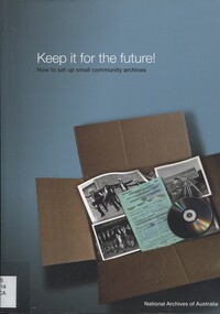 Surrey Hills Historical Society Collection
Book, Keep it for the future - how to set up small community archives, 2007
Contents/Summary: Getting started - collecting records and keeping archives: what are archives?; common mission of archives; types of records; deciding whether to set up an archives or donate records; developing an archives policy -- Acquiring and organising archives: deciding what to keep - appraisal; Receiving records - acquisition; Recording essential information - accessioning; Arranging and describing records -- Preserving archives: storing archives; packaging and containers; Environmental conditions; handling archives -- Accessing archives: access policy; access forms; archives reading room; register of requests for records; security measures; copyright and privacy; guides and fact sheets; copying; volunteers; promotion and display; grants for community heritage collections -- Preparing a disaster recovery plan -- Appendices: Sources for further information; Archiving software; Suppliers of archival papers and products. Soft cover book of 64 pages, indexed; broad areas covered are acquisition, management, preservation, access and disaster plan recovery for community archives.Soft cover book of 64 pages, indexed; broad areas covered are acquisition, management, preservation, access and disaster plan recovery for community archives.archives -
Whitehorse Historical Society Inc.
Pamphlet, Maroondah Highway, Nunawading, 1/10/1999 12:00:00 AM
Auction brochure for 360 Maroondah Highway, Nunawading [Whitehorse Road].Auction brochure for 360 Maroondah Highway, Nunawading [Whitehorse Road]. 3 lots for auction, 27 October 1999. Agent; Collier. Site of the former Nunawading Council Chambers. Includes aerial photo of Nunawading including Whitehorse Rd / Springvale Rd corner and Nunawading Railway Station area.Auction brochure for 360 Maroondah Highway, Nunawading [Whitehorse Road]. whitehorse road, nunawading, no 360, city of nunawading. council chambers, municipal chambers, springvale road, nunawading, nunawading railway station -
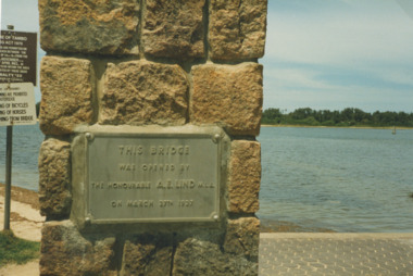 Lakes Entrance Historical Society
Photograph - plaque on footbridge Lakes Entrance Victoria, Bessie Larkins, 1985
plaque at Northern end of the footbridge noting the date of opening by Hon. AE Lind MLA. View across Cunninghame Arm to timbered area at hummocks Lakes Entrance Victoria. Plus a second photo from the foot bridge looking east toward the rotundaColour photograph of plaque at Northern end of the footbridge noting the date of opening by Hon. AE Lind MLA. View across Cunninghame Arm to timbered area at hummocks Lakes Entrance Victoria. Plus a second photo from the foot bridge looking east toward the rotundabridges, waterways, gippsland lakes -
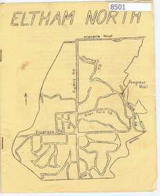 Greensborough Historical Society
Newsletter, Eltham North Progress Association, Eltham North Progress Association Newsletter May 1969, 1969_05
Newsletter of the Eltham North Progress Association 1969 includes an article on the work of the Aboriginal Advancement League, an explanation of how (Diamond Valley) council deals with business and local news.12 p typescript, yellow cover with map of area.eltham north, eltham north progress association -
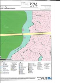 Greensborough Historical Society
Map, Pioneer children's graves precinct, 1848-1860
Map showing the location and surrounds of Pioneer Children's Cemetery on the Plenty River in Greensborough. Children from pioneer families are buried here.Official government planning map for the Pioneer Children's Graves Precinct.Printed coloured copy of map of Plenty River areapioneer childrens cemetery, greensborough, partington, whatmough -
 Greensborough Historical Society
Aerial Photograph, Flintoff land - View from above, 1945_
Section of the 1945 Greensborough aerial survey, focusing on the land belonging to the Flintoff familyPhotocopy of section of 1945 aerial survey of Greensborough area"Flintoff land to west of Diamond Creek Rd" written in pencil on backflintoff family, aerial photograph -
Glenelg Shire Council Cultural Collection
Slide - Slide - Construction Portland/Cashmore Airport, c. 1980
Coloured slide. Grader bogged in area of mud and water. -
Glenelg Shire Council Cultural Collection
Photograph, Photograph - Reclamation, 1953
Port of Portland Authority ArchivesBack: 10 February 1953 - stamp -
Glenelg Shire Council Cultural Collection
Slide - Slide - Cashmore Airport, Portland, 1980s
Coloured slide. Grader working near an area of fire.portland airport, cashmore airport, construction, engineering -
Glenelg Shire Council Cultural Collection
Photograph - Photograph - Casterton, Victoria, n.d
Sourced from Casterton Town Hall (Former Shire of Glenelg)Black and white photo. View of residential area of CastertonBack: Black stamp - 003755 -
Glenelg Shire Council Cultural Collection
Photograph - Photograph - Casterton, Victoria, c. 1963
Sourced from Casterton Town Hall (Former Shire of Glenelg)Black and white photo. View of Casterton, residential areaBack: Black stamp - 003755 -
Ringwood and District Historical Society
Envelope, Packet: Development of Kindergartens (School Project)
Project on the development of kindergartens in the local area and more generally -
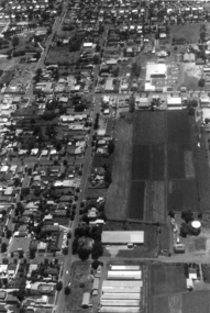 Federation University Historical Collection
Photograph - Colour, Aerial Photograph of an area of Ballarat
Colour photograph showing an aereal view of an area of Ballarataerial, ballarat -
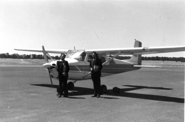 Federation University Historical Collection
Photograph - Colour, Aeroplane at Ballarat Airport before photographing aerial views of Ballarat
Colour photograph showing an aireal view of an area of Ballarataerial, ballarat, aeroplane, ballarat airport -
 Ringwood and District Historical Society
Archive, Hotels in Ringwood District (Parent Record)
This is the parent record for the archives collection of hotels in the Ringwood area. -
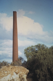 Bendigo Historical Society Inc.
Slide - MALDON & SURROUNDING AREAS, Apr 1968
Slide. Maldon & Surrounding Areas. The 'Beehive' chimney stack.slide, maldon & surrounding areas., maldon & surrounding areas. -
 Bendigo Historical Society Inc.
Slide - MALDON & SURROUNDING AREAS, Apr 1968
Slide. Maldon & Surrounding Areas. Flower covered pagola.slide, maldon & surrounding areas., maldon & surrounding areas. -
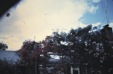
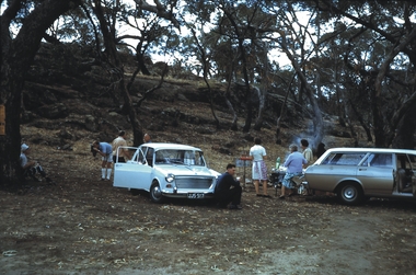 Bendigo Historical Society Inc.
Slide - MALDON & SURROUNDING AREAS, Apr 1968
Slide. Maldon & Surrounding Areas. Friends at a BBQ in the bush.slide, maldon & surrounding areas., maldon & surrounding areas. -
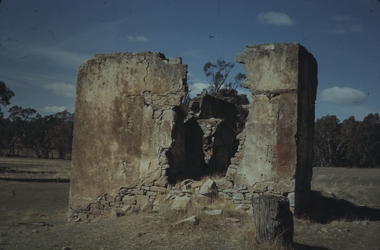 Bendigo Historical Society Inc.
Slide - MALDON & SURROUNDING AREAS, Apr 1968
Slide. Maldon & Surrounding Areas. House remains at Muckleford.slide, maldon & surrounding areas., maldon & surrounding areas.