Showing 1269 items
matching bendigo road
-
 Bendigo Historical Society Inc.
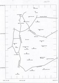
Document - CENTRAL DEBORAH GOLD MINE : GOLDEN SQUARE MINE SITES
Map showing mines in the Golden Square, Diamond Hill area. Roads include Diamond Hill Road, Burns Street, Woodward Road, Belle Vue Road, Houston Street. Latitude and Longitude on map.bendigo, mining, golden square mine sites -
 Bendigo Historical Society Inc.
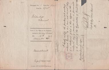
Document - REGISTRATION OF NEW FIRM ABOUT TO COMMENCE BUSINESS
Registration of firms act 1892, form B for registering a new firm about to commence business. Firm name: Eldridge and Burnet. The business is: Ironmongers, Tinsmiths etc. Intend to carry on the business at: Hargreaves Street Bendigo. Signed by Richard Alfred Eldridge of King Street, west Bendigo and John Burnet of White Hills Road. Signed on the 30th October, 1906.business, retail, eldrige and burnet -
 Bendigo Historical Society Inc.
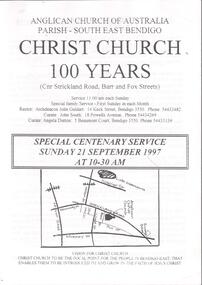
Document - CHURCHES OF BENDIGO COLLECTION: CHRIST CHURCH 100 YEARS
Eleven pages document titled: Anglican Church of Australia Parish-South east Bendigo. Christ Church 100 years (cnr Strickland road, Barr and Fox Streets) Special centenary service Sunday 21 September 1997 at 10-30 am.church, church of christ, centenary -
 Bendigo Historical Society Inc.
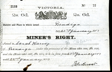
Legal record - WES HARRY COLLECTION: THREE MINER'S RIGHT / RESIDENCY PERMITS
The Miner’s Right has a long history in Australia. Still in use today, it was first established in Victoria in 1855, as a replacement for the Gold License (which had been introduced in Victoria in 1851). The Miner’s Right was subsequently adopted by other Australian colonies. Unlike the Gold License, the early Miner’s Right, in addition to the right to prospect for gold, also carried with it certain other advantages, such as property rights and voting rights. The Miner’s Right came about as a recommendation of a government-appointed commission, which had been appointed on 1854 to look into the troubles on the Victorian goldfields, especially regarding the Eureka Rebellion.Three Miner's Rights / Residency Permits for leases on the corner of Holdsworth Road and Wood Street, Long Gully, Bendigo (Area known as American Gully - downstream of the American Mine): a and b No 72 Sarah Harvey, dated 23/01/1913 c and d No 23148 Evalina Gifford Vivian Harvey, dated 14/09/1926 e and f No 23149 Thomas George Harvey, dated 14/09/1926 Issued by the Victorian Government at a cost of two shillings and six penceVictorian State Governmentwes harry collection, miner's right, bendigo, history, long gully bendigo -
 Bendigo Historical Society Inc.
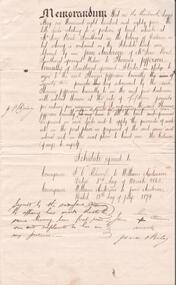
Document - CONSTABLE JOHN BARRY COLLECTION: MEMORANDUM OF EQUITABLE MORTGAGE
Handwriten document, Memorandum: 13th day of May, 1884, 'relating to a portion of land situate at McIvor road, Sandhurst in the colony of Victoria a list thereof is contained in the schedule hereto delivered by me Jane Anderson of McIvor Road Sandhurst, aforesaid widow to Thomas Jeffeson Connelly of Sandhurst aforesaid solicitor in pledge to secure to the aforesaid Thomas Jefferson Connelly the sum of twenty two pounds' Schedule referred to: Conveyance: R.I. Adworth to William Andersn , dated 3rd day of march 1862. Conveyance: William Anderson to Jane Anderson, dated 15th day of July 1879. Signed by the said Jane Anderson by affixing her mark thereto to the same having been first read over and explained to her in my presence. Jane O'Riley. Second page arrached to Memorandum details the transaction between John Barry and Michael Hayes, the trustees of the will of Jane Anderson, and Thomas Jefferson Connelly, on 1st September, 1884. -
 Bendigo Historical Society Inc.
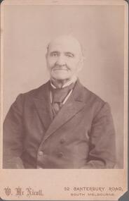
Photograph - ROBINSON COLLECTION: CHARLES ROBINSON
Black and white photograph of on elderly man wearing a dark suit. Photographer name W. McNicoll 52 Canterbury Road, South Melbourne. On the back in red pen Mr. Charles Robinson.person, individual, charles robinson -
 Bendigo Historical Society Inc.
Document - ALBERT RICHARDSON COLLECTION: CARLISLE UNITED MINE GARDEN GULLY LINE
Eight page handwritten document with details of the Carlisle United Gold Mine at Long Gully. The lease was 76 acres, 660 yards on line of reef. The Kent shaft was the next mine north Havilah Road, Boldt Street's corner. 'The Carlisle United was formed by the amalgamation of ttte companies, the Old Carlisle, the North Garden and the Passby. These mines were situated on the west side of Bennett Street in about a length of a few hundred feet, with the Passby on the Casley Street corner. And the old Carlisle and North Garden only recently being unearthed beneath the Unity, 'Carlisle' sand heap.' Details about the mining plant, the main shaft, the winding engine air compressor, stone crusher, and engine house are given. The Kent shaft and steel poppet legs are described. Four early claims on the Carlisle United ground are listed: Morgan, Kirshner and Co., Boyd and Co. Claim, Shanks and Co's claim and Day and Co's claim.bendigo, mining, carlisle united -
 Bendigo Historical Society Inc.
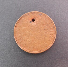
Memorabilia - TRADE TOKEN
Copper token on obverse R.B. Ridler 187 Bridge Road, Richmond, Reverse: Victoria 1862 ''In Vino Veritas''. The token is very well worn and difficult to read. It has an hole for possibly been worn around the neck. It was found at the back of 191 (?) Arnold Street, milkbar shop in a dilapidated stable.numismatics, tokens, r.b. ridler -
 Bendigo Historical Society Inc.
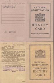
Document - WARNE COLLECTION: NATIONAL REGISTRATION IDENTITY CARD
National registration identity card under sixteen years. Card number DNA 2314998 issued to Janet F, Elliot of Aysgarth Guildford Road, Bisley Surrey valid from 2nd September 1947 till 2nd December 1947. The card is brown in colour. The second National registration temporary identity card number DNA 2314995 issued to Tom E. Elliot class code AV, address Aysgarth Guildford road Bisley Surrey, valid from 2nd September 1947 to 2nd December, 1947.government, federal, identity card -
 Bendigo Historical Society Inc.
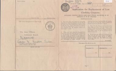
Document - WARNE COLLECTION: APPLICATION FOR REPLACEMENT OF LOST CLOTHING COUPONS
Board of trade, Bagshot food office - Application for replacement of lost clothing coupons. Including coupons which have been stolen, destroyed or so damaged as to be unusable. First page of instructions, second and third form to fill out with particulars of the lost coupons and a declaration. On the back ''On his Majesty's Service'' the area officer, assistance board: Alverstote Clandon Road, Guildford, Surrey. -
 Bendigo Historical Society Inc.
Document - ALBERT RICHARDSON COLLECTION: VICTORIA HILL IRONBARK
Three page handwritten document outlining the history of the Victoria Hill area. The open cuts on Victoria Hill; Lansell's Big 180 Mine, Victoria Quartz Mine; Wittscheibe's 'Jewellers Shop', Luffman and Sterry, Central Nell Gwynne and New Chum Hill are mentioned in the article. A description of the suitability of the Victoria Hill site as a potential mining museum is discussed as 'it is centrla to both the northern and southern ends of the main portion of the Bendigo and Eaglehawk mines'. William Rae built two fine residences on Happy Valley Road, and also set up a 30 head battery out of his gains from Victoria Hill.bendigo, mining, victoria hill -
 Bendigo Historical Society Inc.
Document - ALBERT RICHARDSON COLLECTION: VICTORIA REEF, TRY ME WELL REEF AND HERCULES REEF
Three page handwritten document transcribed by Albert Richardson. On top of document: The Victoria Reef, Victoria Spurs, East Victoria Reef, Try McWell Reef and the Hercules Reef. Reference Dickers Mining Record, Vol 1, No. 1 Page g. November 23, 1861. Document details the location of the reef lines and some of the mines and claims along them. For example, page one: 'The main Victoria, really a continuation of the South Victoria, commences at a point to the west of the Mt Korong Road, where the high portion of the ranges is intersected by the head of the Iron Bark Gully, the southern most claim being Ballerstedt and Son's. This line of reef is remarkable from the extraordinary richness of the lodes, not less than from the singular manner in which the gold has been distributed'.Albert Richardsonbendigo, mining, victoria reef line -
 Bendigo Historical Society Inc.
Document - ALBERT RICHARDSON COLLECTION: SOUTH BELLEVUE COMPANY, NEW CHUM MINE, STH BELLEVUE UNITED
Three page document re South Bellevue, South Bellevue United Co and New Chum gold mines. On top of first page ' Sth Bellevue Manager T.M. Hoppers' 11.10 1886 Harkness made on baling tank 23.4.1887 50 ton firewood per week to bail water out, water making 50,000 gallons in 24 hours. All lifted with one tank. History of New Chum Mine detailed including the plant, best gold obtained. The New Chum mine location is described as follows: between Breen Street and Bendigo to Melbourne raiway line, approx 220 yards east of intersection of McDougall and Bellevue Roads.bendigo, mining, south belle vue -
 Bendigo Historical Society Inc.
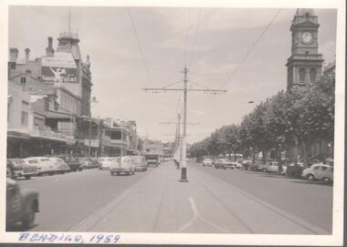
Photograph - BENDIGO VIEWS COLLECTION: PALL MALL
Black and white photograph taken in the middle of the road on the right the old Post Office on the left the Shamrock Hotel. At the bottom in blue pen: Bendigo 1959.bendigo, streetscape, pall mall -
 Bendigo Historical Society Inc.
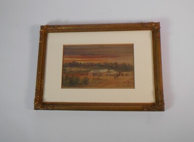
Painting - PAINTING BY GEORGE ROWE: FALCON INN, PEG LEG BENDIGO
Small watercolour painting by George Rowe in a golden wooden frame. Under a red sunset the tipical Australian bush and several tents. The main part of the painting shows the Falcon Inn pub in Peg Leg Eaglehawk, four men are standing at the entrance and two aborigines are walking on the dirt road away from the pub. It is believed to have been painted around 1857.artwork, water colour, landscape, from dudley house. stored at the bendigo art gallery from 2000. returned to bhs 03/02/2023 -
 Bendigo Historical Society Inc.
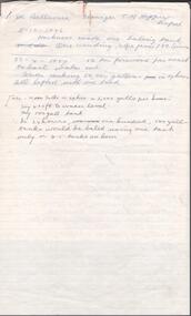
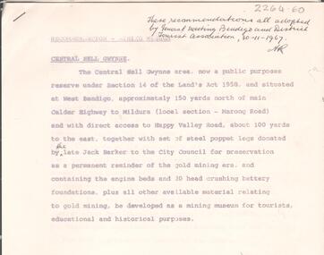
Document - ALBERT RICHARDSON COLLECTION: CENTRAL NELL GWYNNE RECOMMENDATIONS FOR MINING MUSEUM
Six page typed document, signed by Albert Richardson, and a handwritten copy of same. Written on top right of typed document: 'These recommendations all adopted by General Meeting Bendigo and District Tourist Association, 30.11.1967' Document describes the 'Central Nell Gwynne area, situated at West Bendigo, approximately 150 yards north of main Calder Highway to Mildura, local section Marong Road, which is a public purposes reserve under Section 14 of the Land's Act 1958. The steel poppet legs donated by the late Jack Barker to the City Council for preservation be a permanent reminder of the gold mining era and containing the engine beds and 20 head crushing battery foundation, be developed as a mining museum for tourists, educational and historical purposes'bendigo, mining, central nell gwynne -
 Bendigo Historical Society Inc.
Photograph - KEN BICE COLLECTION: WATTLE GULLY GOLD MINE
Laminated faded black and white photograph of the Wattle Gully Gold Mine, Castlemaine. Image shows poppet head, mining shed. Written on back of photo ' Wattle Gully Mine from Fryers Road, 1979'mining, equipment, wattle gully gold mine -
 Bendigo Historical Society Inc.
Document - PETER ELLIS COLLECTION: SUBMISSION BY THE BENDIGO FIELD NATURALIST CLUB FOR THE PRESERVATION OF THE WHIPSTICK THE HISTORY OF THE WHIPSTICK PHOTOS AND NOTES, 1980
PETER ELLIS COLLECTION: SUBMISSION BY THE BENDIGO FIELD NATURALIST CLUB FOR THE PRESERVATION OF THE WHIPSTICK THE HISTORY OF THE WHIPSTICK Photos and Notes Comprised of 81 photos mostly of fauna in the Whipstick. Photos mostly have descriptive notes on labels attached. Letter to The Land Conservation Council 464 St Kilda Road Melbourne 3004 - submission for the final consideration in preparing a final reccomendation for the North Central Area.person, individual, peter ellis oam -
 Bendigo Historical Society Inc.
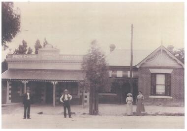
Photograph - BENDIGO HOTEL COLLECTION: COPIES OF PHOTOS OF VARIOUS HOTELS
Seven photocopies of photos of hotels. New Chum Hotel - 1870 J. Matthews showing two men and two women standing at the front. A coloured photo of the New Chum hotel C.15.03.23 is attached. Cricketers' Arms Hotel - T. Nicholson showing a bearded man standing at the front holding a baby. Caledonian Hotel - several men and women standing at the front, one on horseback, a house can be seen at the back of the hotel and Alex Roberts, horseshoer & general merchandise shop next to the hotel. Clyde Hotel - Photos of Thomas Henry Randall, Alice Maud Randall and the Clyde Hotel at the corner of Bull and Myers Street. Under the photos a short biography of the Randall's. Queens' hotel - Large crowd outside and on the balcony of the hotel. Limerick Hotel - grainy black and white photos of the Limerick Hotel in McIvor Road, some people at the front and two trucks also an article from the Bendigo Advertiser titled: ''Revamped Limerick''bendigo, hotel -
 Bendigo Historical Society Inc.
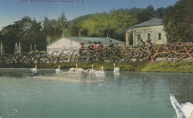
Postcard - POSTCARD. LAKE, BOTANICAL GARDENS, ADELAIDE, S. A, 1912
Postcard with photoof botanical gardens, Adelaide, S. A. Addressed to Narrocott Dunraven 99 Epsom Road Ascot Vale Melbourne. -
Bendigo Historical Society Inc.
Book - 150 YEARS OF LOCAL GOVERNMENT IN EAGLEHAWK
80 page soft cover book entitled 'Rates, Roads & Rubbish - 150 Years of Local Government in Eaglhawk'. Published July 2012 by the Eaglehawk Heritage Society. Cover design by Aylene Kirkwood B&W photos of people and places year by year, 1862 to 2012.Eaglehawk Heritage Society -
Bendigo Historical Society Inc.
Map - MAP WHITE HILL TO HUNTLY
Map of Bendigo creek and adjacent leads - White Hills to Huntly replotted from old 4 chain to 1 inch survey of 1860 by G. W. Hart - Surveyor. Base of roads and streets taken from D.L.S. 1 . 10000 base maps. Legend: battery site, puddling mill site, dam bank site, cutting altering course of creek, lead boundaries.bendigo, mining -
Bendigo Historical Society Inc.
Photograph - BENDIGO SHOWGROUNDS
Aerial black and white photograph of the Bendigo showgrounds. Date unknown. There is a sticker 'you are now here at the stand of Frank A. Hill & co. Several of the pavilion are named: horses (x4), cattle, pigs, Lansell Hall, sheep, wool, dogs, poultry booth, sideshows, centre hall, park road hall and luncheon.bendigo, streetscape, showgrounds -
Bendigo Historical Society Inc.
Photograph - LONG GULLY HISTORY GROUP COLLECTION: EAGLEHAWK ROAD LONG GULLY
Large black and white photograph of Eaglehawk Road Long Gully. Showing on the right hand side at the front a light pole with a sign Methodist Church followed by butcher shop, few houses, a church and a poppet head. On the left side of the road a series of houses. A tram and two cars can be seen on the road.bendigo, streetscape, long gully -
 Bendigo Historical Society Inc.
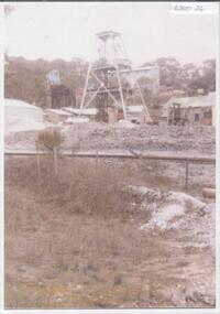
Document - DEAD DOG GULLY DIAMOND HILL
Description of the Dead Dog Gully (1.2) area on Diamond Hill, researched and described by David Bannear, two page document. Dead Dog Gully runs alongside Burns Road, Spring Gully. History of the area is given from 1860 onwards. Reference to Spring Gully Reservoir and water availability for mining in the area.bendigo, mining, dead dog gully -
 Bendigo Historical Society Inc.
Document - GOLDEN GULLY ALLUVIAL WORKINGS
Golden Gully alluvial workings, Diamond Hill area, site number 1.1. Document has map/grid references, parcel number and location - runs along Woodward Road. History from 1851 to 186 detailed. . Information from David Bannear's Bendigo goldfields survey. -
 Bendigo Historical Society Inc.
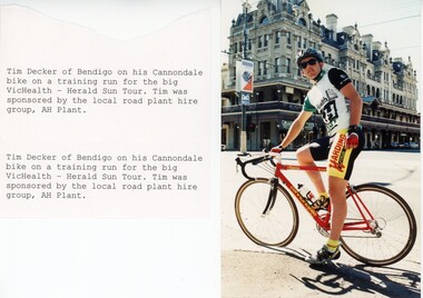
Photograph - BENDIGO ADVERTISER COLLECTION: BIKES, 1990s
Photograph: Man on racing bike in front of Shamrock Hotel Bendigo and attached notes: 'Tim decker of Bendigo on his Cannondale bike on a trainig run for the big VicHealth - Herald Sun Tour. Tim was sponsored by the local road plant hire group, AH Plant.'recreations, sports, cycling, bendigo advertiser -
 Bendigo Historical Society Inc.
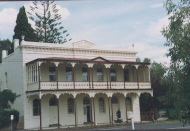
Photograph - ESTELLE HEWSTON COLLECTION: GOLD MINES HOTEL FAÇADE, MARONG ROAD, JANUARY 1994
Colour photograph of Gold Mines Hotel, dated January 1994Estelle Hewston -
 Bendigo Historical Society Inc.
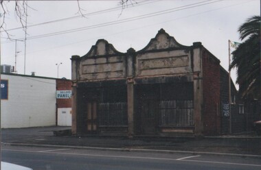
Photograph - ESTELLE HEWSTON COLELCTION: PHOTOGRAPH OF TWO ATTACHED SHOPS / TERRACE BUILDINGS, SAILORS GULLY ROAD, EAGLEHAWK, November 1996
colour photograph of two attached terrace buildings, shop sites , Sailors Gully Road, EaglehawkEstelle Hewston -
 Bendigo Historical Society Inc.
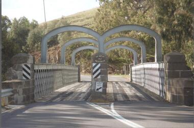
Photograph - BENDIGO HISTORICAL SOCIETY COLLECTION: REDESDALE BRIDGE
Colour photograph of the Redesdale bridge over the Campaspe River at Redesdale. The Redesdale Bridge is one of the oldest iron lattice-truss bridges in Victoria, Australia. The Redesdale Bridge is a wrought iron and timber structure with bluestone abutments, located over the Campaspe River near the town of Redesdale. Image taken from Redesdale side of bridge showing two lane design. Plaque on bridge in centre of divided road reads ' Shire of Metcalfe'. Photo taken during a BHS tour, possibly 1990's.bridge