Showing 1440 items
matching black photo album
-
 Eltham District Historical Society Inc
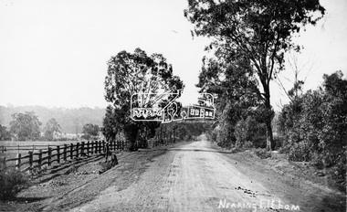
Photograph, Tom Prior, Nearing Eltham, from Research, Vic., c.1905, c.1905
View looking south along the main road from Research to Eltham Part of a presentation, "Roads and Byways of the Shire of Eltham", by Russell Yeoman to the 12 September 1990 Society meeting. Slides shown inclyuded copies of old photos and recent images ranging from the suburban streets of Eltham and Montmorency to the mountain roads of Kinglake. In the byways category are views of some iof the Shire's bicycle paths including then recently completed sections of the Main Yarra Trail at Lower Plenty.This photo forms part of a collection of photographs gathered by the Shire of Eltham for their centenary project book,"Pioneers and Painters: 100 years of the Shire of Eltham" by Alan Marshall (1971). The collection of over 500 images is held in partnership between Eltham District Historical Society and Yarra Plenty Regional Library (Eltham Library) and is now formally known as the 'The Shire of Eltham Pioneers Photograph Collection.' It is significant in being the first community sourced collection representing the places and people of the Shire's first one hundred years. The Reynolds family were early settlers in Research. The Reynolds/ Prior collection of photographs were taken by Tom Prior, the maternal uncle of Ivy Reynolds, around 1900 and the 60 photos in the album give a fine overview of many of the landmarks of Research and Eltham over 100 years ago. lvy lived in the family home for many years at 106 Thompson Cres Research. Ivy's father, Ernst Richard Reynolds and grandfather, Richard Reynolds, lived at the same address. Ivy's father Richard worked for Mr. Trail on his property in Research. Reynolds Road is named after the family. Mr Tom Prior (wife Eva) worked at the Melbourne zoo. He was very innovative and made his own camera, using the black cloth hood to exclude the light. The photographs are a reminder of the rural nature of Research and Eltham and its rich heritage.Digital image (Neg missing)shire of eltham pioneers photograph collection, eltham, main road, research (vic.), reynolds prior collection -
 Eltham District Historical Society Inc
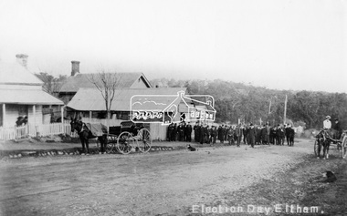
Negative - Photograph, Tom Prior, Election Day, Eltham, 4 June 1907
Election Day, Legislative Council Elections, Tuesday, 4 June 1907, Maria Street (Main Road), Eltham. Group of men standing outside George Knapman’s forge on Election Day (4 June 1907) for the Legislative Council. Voting was conducted in the Eltham Courthouse next door, visible behind the forge. At that time women did not have the right to vote; two women wait on the horse and buggy and two others are looking on from the verandah of the house next door. A dog also sits patiently on the road. The Police Station and residence are just visible on the corner of Brougham Street. Reproduced on p62 of 'Pioneers & Painters' Cross Ref: 0629This photo forms part of a collection of photographs gathered by the Shire of Eltham for their centenary project book,"Pioneers and Painters: 100 years of the Shire of Eltham" by Alan Marshall (1971). The collection of over 500 images is held in partnership between Eltham District Historical Society and Yarra Plenty Regional Library (Eltham Library) and is now formally known as the 'The Shire of Eltham Pioneers Photograph Collection.' It is significant in being the first community sourced collection representing the places and people of the Shire's first one hundred years. The Reynolds family were early settlers in Research. The Reynolds/ Prior collection of photographs were taken by Tom Prior, the maternal uncle of Ivy Reynolds, around 1900 and the 60 photos in the album give a fine overview of many of the landmarks of Research and Eltham over 100 years ago. lvy lived in the family home for many years at 106 Thompson Cres Research. Ivy's father, Ernst Richard Reynolds and grandfather, Richard Reynolds, lived at the same address. Ivy's father Richard worked for Mr. Trail on his property in Research. Reynolds Road is named after the family. Mr Tom Prior (wife Eva) worked at the Melbourne zoo. He was very innovative and made his own camera, using the black cloth hood to exclude the light. The photographs are a reminder of the rural nature of Research and Eltham and its rich heritage.Digital image 4 x 5 inch B&W Negshire of eltham pioneers photograph collection, eltham, main road, knapman's forge, election day, elections, eltham courthouse, forge, george knapman, knapmans forge, maria street, pioneers and painters, reynolds prior collection, court house, courthouse, g. knapman, sepp -
 Eltham District Historical Society Inc
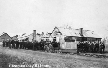
Negative - Photograph, Tom Prior, Election Day, Eltham, 4 June 1907
Election Day, Legislative Council Elections, Tuesday, 4 June 1907, Maria Street (Main Road), Eltham. Group of men standing outside George Knapman’s forge on Election Day (4 June 1907) for the Legislative Council. Voting was conducted in the Eltham Courthouse next door, to the right of photo. At that time women did not have the right to vote. At the far left can be see William B. Andrew’s Corn Store on the corner of Franklin Street. The weatherboard house in between at one stage the home of Miss George.This photo forms part of a collection of photographs gathered by the Shire of Eltham for their centenary project book,"Pioneers and Painters: 100 years of the Shire of Eltham" by Alan Marshall (1971). The collection of over 500 images is held in partnership between Eltham District Historical Society and Yarra Plenty Regional Library (Eltham Library) and is now formally known as the 'The Shire of Eltham Pioneers Photograph Collection.' It is significant in being the first community sourced collection representing the places and people of the Shire's first one hundred years. The Reynolds family were early settlers in Research. The Reynolds/ Prior collection of photographs were taken by Tom Prior, the maternal uncle of Ivy Reynolds, around 1900 and the 60 photos in the album give a fine overview of many of the landmarks of Research and Eltham over 100 years ago. lvy lived in the family home for many years at 106 Thompson Cres Research. Ivy's father, Ernst Richard Reynolds and grandfather, Richard Reynolds, lived at the same address. Ivy's father Richard worked for Mr. Trail on his property in Research. Reynolds Road is named after the family. Mr Tom Prior (wife Eva) worked at the Melbourne zoo. He was very innovative and made his own camera, using the black cloth hood to exclude the light. The photographs are a reminder of the rural nature of Research and Eltham and its rich heritage.Digital image 4 x 5 inch B&W Negelection day, elections, eltham, eltham courthouse, forge, george knapman, knapmans forge, main road, maria street, miss george, reynolds prior collection, shire of eltham pioneers photograph collection, w.b. andrew corn store -
 Eltham District Historical Society Inc
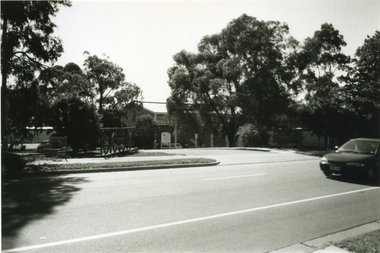
Photograph, Tom Prior, Police Station and Residence, Maria Street, Eltham, c.1900
Situated near the top of what was known as 'Policeman's Hill' according to Miss Ivy Reynolds, neice of the photographer, Tom Prior. From the left, Eltham Court House, Police Residence and Police station on Main Road and corner of Brougham Street. These buildings formed part of Little Eltham and still stand (without the front fence) today though the Police Station was demolished in 1986 due to termite damage. A replica was built circa 1989. The institutions of law and order in Colonial Victoria included the police, courts and prisons. The 1852 report of the Snodgrass Select Committee appointed to "identify the policing needs of the colony” noted there existed seven independent police forces that did not co-operate or regularly communicate. Following the committee's report all these police entities were merged into the Victoria Police, founded on 8 January 1853, to implement law and order responsibilities throughout the Colony of Victoria. The Eltham Courthouse (1860) and adjacent Police Residence (1859) formed a justice precinct established in the immediate aftermath of the 1852 police inquiry and the effects of the gold rush. The physical presence of these buildings, in the centre of the early Eltham township, defined centralised control over law and order. In the early days the Police Constable in charge would conduct his duties travelling around the district by horse; a stable was located at the rear of the residence. At times the horse would be grazed on the paddocks across the road. Horseshoes were forged by the blacksmith beside the Courthouse on the high side of “Policeman’s Hill”. Along with the stable, there was a two-cell bluestone lockup where prisoners were held awaiting trial in the adjacent Courthouse. Their meals were usually provided by the policeman’s wife or from the hotel just up the road. With the arrival of the railway in 1902 the town centre gradually shifted towards the railway station. The Police Station and operations were moved into the town centre in 1961 to a renovated house in Pryor Street, which was later replaced by the current Police Station. From 1961-1981 the residence was occupied by the Vermin and Noxious Weeds Destruction Section of the Department of Crown Lands and Survey. Prior to August 1967 the former Police Station was dragged to the rear of Police Residence to make way for the construction of a driveway and access from Main Road. The building was placed on the site of a former Scullery and modified for Lands Department use. In 1981 the Shire of Eltham took over management of the former Police Residence in Eltham. It remained unoccupied for a period whilst its future was discussed in Council. It was then used for a community job creation scheme until 1985. In 1985 the Shire of Eltham Parks and Environment occupied the residence. Council improved the driveway but later added a second rear access from Brougham Street due to the dangerous nature of the Main Road entrance. Additionally, a rear toilet facility between the Police Residence and the relocated former Police Station, which was doubling up as a lunchroom. Council also commenced discussions to re-establish a replica Police Station. Around November 1986 the former Police Station was demolished; believed to have been suffering termite damage. About 1989, after some years of discussion, a replica Police Station was built, based on photographs, to act as a lunchroom and meeting room for the Parks and Environment staff and volunteers doing community service. In 1996 Eltham District Historical Society held discussions with Nillumbik Shire Council commissioners throughout the year regarding a home for the Society. A proposal was put forward by the Society in October to occupy the former Police Residence. In March 1997 Eltham District Historical Society gained access to former Police Residence and on July 12, 1998, moved into its Local History Centre. In July 2018, Eltham District Historical Society gained access to the replica Police Station (which had been used as a music library and storage for the Eltham Concert Band) for use as part of regular heritage tours for schools and community-based groups.This photo forms part of a collection of photographs gathered by the Shire of Eltham for their centenary project book,"Pioneers and Painters: 100 years of the Shire of Eltham" by Alan Marshall (1971). The collection of over 500 images is held in partnership between Eltham District Historical Society and Yarra Plenty Regional Library (Eltham Library) and is now formally known as 'The Shire of Eltham Pioneers Photograph Collection.' It is significant in being the first community sourced collection representing the places and people of the Shire's first one hundred years. The Reynolds family were early settlers in Research. The Reynolds/ Prior collection of photographs were taken by Tom Prior, the maternal uncle of Ivy Reynolds, around 1900 and the 60 photos in the album give a fine overview of many of the landmarks of Research and Eltham over 100 years ago. lvy lived in the family home for many years at 106 Thompson Cres Research. Ivy's father, Ernst Richard Reynolds and grandfather, Richard Reynolds, lived at the same address. Ivy's father Richard worked for Mr. Trail on his property in Research. Reynolds Road is named after the family. Mr Tom Prior (wife Eva) worked at the Melbourne zoo. He was very innovative and made his own camera, using the black cloth hood to exclude the light. The photographs are a reminder of the rural nature of Research and Eltham and its rich heritage.Digital imagechildren, court house, courthouse, eltham, eltham district historical society, eltham justice precinct, little eltham, local history centre, main road, police residence, police station, reynolds prior collection, sepp, shadow, shire of eltham pioneers photograph collection -
 Ringwood and District Historical Society
Photograph - Black and White, East Ringwood 2000-Drill Hall in Dublin Road
East Ringwood 2000-Drill Hall in Dublin Road- B&W Photo from Album 6501 -
 Ringwood and District Historical Society
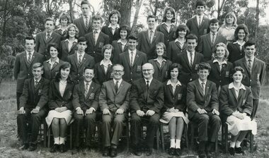
Photograph - Group, Ringwood Technical School 1963 Prefects
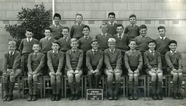
As well as the usual Prefects’ duties, their assistance was required for frequent special occasions at the school in its early years, some involving overseas visitors who were given tours of the new school, it being the first co-ed technical school in Victoria and of a unique design. The school, known locally as Ringwood Tech School, Ringwood Tech, Ringy Tech, Ringers Tech, The Tech and RTS, began in 1958 and was hosted at various district schools until 1960, when the new school was completed at Heathmont. It was the first co-ed technical school in Victoria. The school underwent several name and role changes in later years, and finally closed in 2003.Black and White Photograph - RTS Prefects, 1963 Photograph from Ringwood Technical School photo album 21255 labelled “Ringwood Technical School 1963-’64 Class Photos”. (This record was also catalogued as 17091, replaced by this entry)Names: Top row: Patsy Bulstrode, ?, Irene Rye, Elaine Smith, Gary Dewar, Sandra Rudeforth. 3rd row: Robert Tann, Diane Trueman, Tom Derham, Gail Reddish, Trevor Kane, Denise Young, Stephen Alsop, Rosemary Dobrowolski. 2nd row: Ken Washfold, Carmen Powell, ?, Ann Bassett, Terry Keatch, Julie Stephens, John Wilson, Janice Hartley, Gavin Miller. 1st row: Richard Gardner, Derry Truman, Darryl Hodgkins, Principal: Mr E Heard, Teacher: Mr Doug Thomas, Janine Allen, Alan Cornhill, ?. rts, ringwood tech -
 Ringwood and District Historical Society
Album - Group/Class Photos, Ringwood Technical School 1965-1966 bound Album, c 1965-1966
Red Bound Photograph Album of Black and White Class/Group Photos from 1963-64rts, ringwood tech -
 Ringwood and District Historical Society
Album - Group/Class Photos, Ringwood Technical School 1963-1964 bound Album, c 1963
Red Bound Photograph Album of Black and White Class/Group Photos from 1963-64rts, ringwood tech -
 Ringwood and District Historical Society
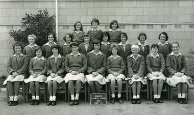
Photograph - Group, Ringwood Technical School 1963 Form 1A, c 1963
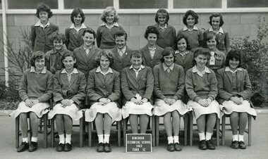
This Form was part of the largest intake to date as Ringwood Technical School entered its fourth year at the Heathmont Road campus. The 269 Form 1 students in 12 groups, 1A to 1M, took the school’s population to nearly 700. Extensions to the 3 year old building commenced during the year to help accommodate the expected rising numbers of students.Black and White Photograph Names: Top row: Heather Gray, Stephanie Graham, Cheryl-Ann Mitchell. 2nd row: Elizabeth Dedman, Jennifer Gribble, Lynette Lindsay, Dianne Cahill, Sandra Aitcheson, Kaye Boyle, Kay Meloni, Doreece Bradshaw. 1st row: Fenna Paas, Georgia Thomson, Vicki Jenkins, Robyn Whitchurch, Lynette Allan, Suzanne Leverington, Linda Hickman, Gwenda Hall, Valerie Robinson. Photograph from Ringwood Technical School photo album labelled “Ringwood Technical School 1963-’64 Class Photos”. rts, ringwood tech -
 Ringwood and District Historical Society
Photograph - Group, Ringwood Technical School 1963 Form 1B
This Form was part of the largest intake to date as Ringwood Technical School entered its fourth year at the Heathmont Road campus. The 269 Form 1 students in 12 groups, 1A to 1M, took the school’s population to nearly 700. Extensions to the 3 year old building commenced during the year to help accommodate the expected rising numbers of students.Black and White Photograph Names: Top: Kurt Herdina, Keith Foote, Alan Dear, David Austin 2nd row: Albert Austin, Gary Evans, Alan Robertson, Peter Terry, Geoffrey Bomford, Fred Painter, Robert Batt, Alan Hoffmann 1st row: Rodney Barber, Brian Parlby , Malcolm Grant, Donald Creed, Gerald Pels, Stephen Loosley, Richard Hudson , Rodney Holloway, Paul Shadbolt Photograph from Ringwood Technical School photo album labelled “Ringwood Technical School 1963-’64 Class Photos”. rts, ringwood tech -
 Ringwood and District Historical Society
Photograph - Group, Ringwood Technical School 1963 Form 1C
This Form was part of the largest intake to date as Ringwood Technical School entered its fourth year at the Heathmont Road campus. The 269 Form 1 students in 12 groups, 1A to 1M, took the school’s population to nearly 700. Extensions to the 3 year old building commenced during the year to help accommodate the expected rising numbers of students. The school was known locally as Ringwood Tech School, Ringwood Tech, Ringy Tech, Ringers, The Tech and RTS.Black and White Photograph Photograph from Ringwood Technical School photo album labelled “Ringwood Technical School 1963-’64 Class Photos” (VC 21255)Names: Top row: Lorraine Gibbs, Elaine Gration, Anita Smith, Patricia O’Dea, Ann McGregor, Sandra Diprose. 2nd row: Sandra Thomas, Robyn Jensen, Therese Birchall, Gail Phillips, Judith Flarherty, Joan ?. 1st row: Jeanette Miles, Judith Cruickshank, Yvonne Aston, Susan Marsden, Heidi Henkel, Rosemary D’Orival Margaret Piergrosse.rts, ringwood tech -
 Ringwood and District Historical Society
Photograph - Group, Ringwood Technical School 1963 Form 1D
This Form was part of the largest intake to date as Ringwood Technical School entered its fourth year at the Heathmont Road campus. The 269 Form 1 students in 12 groups, 1A to 1M, took the school’s population to nearly 700. Extensions to the 3 year old building commenced during the year to help accommodate the expected rising numbers of students.Black and White Photograph - Ringwood Technical School 1963 Form 1D Boys Photograph from Ringwood Technical School photo album labelled “Ringwood Technical School 1963-’64 Class Photos” (VC 21255)Names: Top row: ? , Brian Glassborough, Mark Bremner, ?, Colin Doak, ?, Clive Houston, Richard Dobrowolski. 2nd row: Robert Lavin, ?, Christopher Robinson, Lindsay Washusen, ?, Vincent Powell, David Cleator. Kim Robinson. 1st row: Raymond Sparkes.rts, ringwood tech -
 Marysville & District Historical Society
Postcard (item) - Black and white photographs, Valentine Publishing Co. Pty. Ltd, Valentine's Snapshots MARYSVILLE, Victoria, 1923-1963
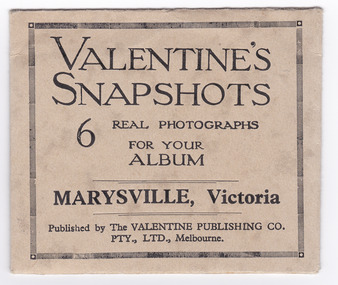
This collection of photographs shows various scenes around Marysville and surrounds such as waterfalls and rivers. Valentines snapshots were done of many places world wide, and packaged in a convenient size to be posted.An envelope with 6 black and white photographs of scenic attractions taken in and around Marysville in Victoria.VALENTINE'S/ SNAPSHOTS/ 6 REAL PHOTOGRAPHS/ FOR YOUR/ ALBUM/ MARYSVILLE, Victoria/ Published by The VALENTINE PUBLISHING CO.,/ PTY., LTD., Melbourne. To From Design 539/ PRINTED IN GT BRITAINtaggerty river (image 1), acheron way (image 2), nicholl's lookout (image 3), main street marysville (image 4), stevensons falls (image 5), cora lynn falls (image 6), valentine publishing co, marysville, victoria, souvenir -
 Eltham District Historical Society Inc
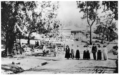
Negative - Photograph, Tom Prior, Main Road, Hurstbridge, c.1912
Seven women and one man strolling down Main road, Hurstbridge. They have possibly arrived for a visit on the train, when the railway line was extended from Eltham to Hurstrbridge in 1912. This photo is also contained in the Reynolds-Prior CollectionThis photo forms part of a collection of photographs gathered by the Shire of Eltham for their centenary project book, "Pioneers and Painters: 100 years of the Shire of Eltham" by Alan Marshall (1971). The collection of over 500 images is held in partnership between Eltham District Historical Society and Yarra Plenty Regional Library (Eltham Library) and is now formally known as 'The Shire of Eltham Pioneers Photograph Collection.' It is significant in being the first community sourced collection representing the places and people of the Shire's first one hundred years. The Reynolds family were early settlers in Research. The Reynolds/ Prior collection of photographs were taken by Tom Prior, the maternal uncle of Ivy Reynolds, around 1900 and the 60 photos in the album give a fine overview of many of the landmarks of Research and Eltham over 100 years ago. lvy lived in the family home for many years at 106 Thompson Cres Research. Ivy's father, Ernst Richard Reynolds and grandfather, Richard Reynolds, lived at the same address. Ivy's father Richard worked for Mr. Trail on his property in Research. Reynolds Road is named after the family. Mr Tom Prior (wife Eva) worked at the Melbourne zoo. He was very innovative and made his own camera, using the black cloth hood to exclude the light. The photographs are a reminder of the rural nature of Research and Eltham and its rich heritage.Digital image 4 x 5 inch B&W Negsepp, shire of eltham pioneers photograph collection, hurstbridge, main road, reynolds prior collection -
 Glen Eira Historical Society
Album - Album page, Inkerman Street, Circa 1972
This photograph is part of the Caulfield Historical Album 1972. This album was created in approximately 1972 as part of a project by the Caulfield Historical Society to assist in identifying buildings worthy of preservation. The album is related to a Survey the Caulfield Historical Society developed in collaboration with the National Trust of Australia (Victoria) and Caulfield City Council to identify historic buildings within the City of Caulfield that warranted the protection of a National Trust Classification. Principal photographer thought to be Trevor Hart, member of Caulfield Historical Society. Most photographs were taken between 1966-1972 with a small number of photographs being older and from unknown sources. All photographs are black and white except where stated, with 386 photographs over 198 pages. Page 101 of Photograph Album with two photographs (landscape) of a house on Inkerman Street.Handwritten: 656 INKERMAN 3/10/1972 [under top left photo] / 101 [bottom left]trevor hart, east st kilda, inkerman street, st kilda east, edwardian, timber, single storey, fretwork, garden, gable, verandahs, architectural feautures, inkerman road, caulfield north -
 Glen Eira Historical Society
Album - Album page, Koornang Road, Circa 1972
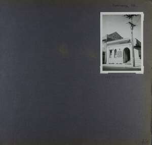
This photograph is part of the Caulfield Historical Album 1972. This album was created in approximately 1972 as part of a project by the Caulfield Historical Society to assist in identifying buildings worthy of preservation. The album is related to a Survey the Caulfield Historical Society developed in collaboration with the National Trust of Australia (Victoria) and Caulfield City Council to identify historic buildings within the City of Caulfield that warranted the protection of a National Trust Classification. Principal photographer thought to be Trevor Hart, member of Caulfield Historical Society. Most photographs were taken between 1966-1972 with a small number of photographs being older and from unknown sources. All photographs are black and white except where stated, with 386 photographs over 198 pages. 1970 Sands & McDougall Directory shows UFS Dispensary at address.Page 106 of Photograph Album with one photograph (portrait) of a pharmacy on Koornang Road.Handwritten: Koornang Rd [top right] / 162 KOORNANG RD [under photo] / 106 [bottom right]trevor hart, koornang road, carnegie, rosstown, dispensary, pharmacies, shops, commercial establishments, ufs dispensary, arches -
 Glen Eira Historical Society
Album - Album page, Lynedoch Avenue, Circa 1972
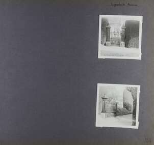
This photograph is part of the Caulfield Historical Album 1972. This album was created in approximately 1972 as part of a project by the Caulfield Historical Society to assist in identifying buildings worthy of preservation. The album is related to a Survey the Caulfield Historical Society developed in collaboration with the National Trust of Australia (Victoria) and Caulfield City Council to identify historic buildings within the City of Caulfield that warranted the protection of a National Trust Classification. Principal photographer thought to be Trevor Hart, member of Caulfield Historical Society. Most photographs were taken between 1966-1972 with a small number of photographs being older and from unknown sources. All photographs are black and white except where stated, with 386 photographs over 198 pages. National Trust - 9 Lynedoch Avenue, CAULFIELD NORTH VIC 3161 - Property No B3310 https://vhd.heritagecouncil.vic.gov.au/places/65663 - this record is just one photo with no text; the photo is almost identical to the photograph of the smaller gate on this album page. Page 124 of Photograph Album with two square photographs of gates.Handwritten: Lynedoch Avenue [top right] / 124 [bottom right]trevor hart, gates, cast iron gate, caulfield north, gate, hedge, cast iron spears, stone plinths, masonry column, masonry pillar, lynedoch avenue, st kilda east -
 Glen Eira Historical Society
Album - Album page, Maysbury, Maysbury Avenue, Circa 1972
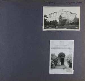
This photograph is part of the Caulfield Historical Album 1972. This album was created in approximately 1972 as part of a project by the Caulfield Historical Society to assist in identifying buildings worthy of preservation. The album is related to a Survey the Caulfield Historical Society developed in collaboration with the National Trust of Australia (Victoria) and Caulfield City Council to identify historic buildings within the City of Caulfield that warranted the protection of a National Trust Classification. Principal photographer thought to be Trevor Hart, member of Caulfield Historical Society. Most photographs were taken between 1966-1972 with a small number of photographs being older and from unknown sources. All photographs are black and white except where stated, with 386 photographs over 198 pages. Page 132 of Photograph Album with two photographs (one landscape, one portrait) of "Maysbury".Handwritten: "Maysbury" Maysbury Street/Avenue [top right] / 1972 Neg 47 [under top photo] / 132 [bottom right]trevor hart, windows, victorian, 1880's, maysbury, maysbury mansions, flats, decorative brackets, double storey, italianate, cast iron stair balustrading, cast iron balustrading, bay window, protruding rooms, bluestone fence, elsternwick, maysbury avenue, mansion, victorian style, arches, entrances -
 Glen Eira Historical Society
Album - Album page, Neerim Road, Circa 1972
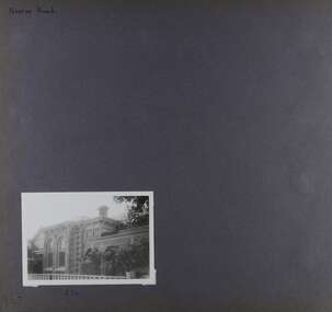
This photograph is part of the Caulfield Historical Album 1972. This album was created in approximately 1972 as part of a project by the Caulfield Historical Society to assist in identifying buildings worthy of preservation. The album is related to a Survey the Caulfield Historical Society developed in collaboration with the National Trust of Australia (Victoria) and Caulfield City Council to identify historic buildings within the City of Caulfield that warranted the protection of a National Trust Classification. Principal photographer thought to be Trevor Hart, member of Caulfield Historical Society. Most photographs were taken between 1966-1972 with a small number of photographs being older and from unknown sources. All photographs are black and white except where stated, with 386 photographs over 198 pages. Property is included the City of Glen Eira's Amendment C190glen as HO177 Ida Villa. As of 18/03/2021, Amendment C190 is noted as "Approval Under Consideration" by the Minister of Planning.Page 147 of Photograph Album with one landscape photograph of a Victorian brick house on Neerim Road.Handwritten: Neerim Road [top left] / 234 [under photo] / 147 [bottom left]trevor hart, neerim road, arched windows, verandah, porch, decorative brackets, bull nosed verandah, cast iron columns, ross land sales, ross, carnegie, victorian style, cast iron work, polychrome bricks, brick houses, tessellated tiled deck, ida villa -
 Glen Eira Historical Society
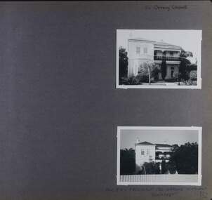
Album - Album page, 84 Orrong Crescent, Circa 1972
This photograph is part of the Caulfield Historical Album 1972. This album was created in approximately 1972 as part of a project by the Caulfield Historical Society to assist in identifying buildings worthy of preservation. The album is related to a Survey the Caulfield Historical Society developed in collaboration with the National Trust of Australia (Victoria) and Caulfield City Council to identify historic buildings within the City of Caulfield that warranted the protection of a National Trust Classification. Principal photographer thought to be Trevor Hart, member of Caulfield Historical Society. Most photographs were taken between 1966-1972 with a small number of photographs being older and from unknown sources. All photographs are black and white except where stated, with 386 photographs over 198 pages. From Victorian Heritage Database citation for 84 Orrong Crescent https://vhd.heritagecouncil.vic.gov.au/places/35584 as at (28/10/2020) "St. Reliers" at 84 Orrong Crescent is important as an unusually excessively enriched asymmetrical villa residence of the Boom period. From Victorian Heritage Database citation for HO50 84 Orrong Crescent Caulfield North https://vhd.heritagecouncil.vic.gov.au/places/35584 as at (28/10/2020) An imposing Italianate two storeyed asymmetrical villa with overpainted stuccoed surfaces to the facade, distinguished by their ornate treatment. Unusually rich ornamentation includes the acanthus leaf impost capitals, aedicules with swags and volutes, foliated panels to the frieze, ashlar treatment to the lower level and quoins above. The two storeyed cast iron verandah with timber frieze rail protects a black and white tiled floor. The hipped roof has patterned slates.Page 152 of Photograph Album with two landscape photographs of Bonhurst on Orrong Crescent.Handwritten: 84 Orrong Crescent [top right] / NOW 84 - PREVIOUSLY 120 ORRONG CRESCENT / "BONHURST" [under bottom photo] / 152 [bottom right]trevor hart, verandah, porch, slate roof, garden, decorative brackets, fanlight, protruding bay, bay window, garden lamp, asymmetrical, bonhurst, st reliers, rendered, orrong crescent, caulfield north, cast iron work, victorian style, mansions, house names, slate roofs, italianate style -
 Glen Eira Historical Society
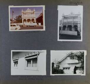
Album - Album page, Orrong Road, Circa 1972
This photograph is part of the Caulfield Historical Album 1972. This album was created in approximately 1972 as part of a project by the Caulfield Historical Society to assist in identifying buildings worthy of preservation. The album is related to a Survey the Caulfield Historical Society developed in collaboration with the National Trust of Australia (Victoria) and Caulfield City Council to identify historic buildings within the City of Caulfield that warranted the protection of a National Trust Classification. Principal photographer thought to be Trevor Hart, member of Caulfield Historical Society. Most photographs were taken between 1966-1972 with a small number of photographs being older and from unknown sources. All photographs are black and white except where stated, with 386 photographs over 198 pages.Victorian Heritage Database https://vhd.heritagecouncil.vic.gov.au/places/35576 No. 70 Orrong Road is important as an exceptionally ornate Boom style villa residence in the terraced form and in this respect is rare in Caulfield. Its architectural value is enhanced by its intact state and by the manner in which its bold architectural expression is carried through into the hallway and staircase. Victorian Heritage Database - National Trust local significance 284 Orrong Road Caulfield https://vhd.heritagecouncil.vic.gov.au/places/65700 A house designed by Harold Desbrowe Annear in 1917 and believed to have been the first "all electric" house in Melbourne. It has been extensively altered.Page 164 - four photographs of 2 different houses on Orrong Road. The top left photo is in colour while the others are in black and white.Handwritten: Orrong Road [top right] / Lisborn House [ (ed. correct name is LISBON HOUSE), under top left photo] / Lisborn House [under top right photo] / [under bottom right photo] / CORNER ORRONG ROAD AND PEARSON AVENUE / HOUSE BY DESBROWE ANNEAR [under bottom left photo] / 164 [bottom right]trevor hart, orrong road, lisbon house, lisborn house, elsternwick, pearson grove, st kilda east, caulfield north, terrace houses, cast iron work, verandahs, balconies, parapets, arches, cars, streetscapes, attic houses, desbrowe annear -
 Glen Eira Historical Society
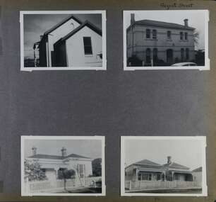
Album - Album page, Regent Street, Circa 1972
This photograph is part of the Caulfield Historical Album 1972. This album was created in approximately 1972 as part of a project by the Caulfield Historical Society to assist in identifying buildings worthy of preservation. The album is related to a Survey the Caulfield Historical Society developed in collaboration with the National Trust of Australia (Victoria) and Caulfield City Council to identify historic buildings within the City of Caulfield that warranted the protection of a National Trust Classification. Principal photographer thought to be Trevor Hart, member of Caulfield Historical Society. Most photographs were taken between 1966-1972 with a small number of photographs being older and from unknown sources. All photographs are black and white except where stated, with 386 photographs over 198 pages. At least 2 of these houses (17 and 84) are contributory properties to HO72 Elsternwick Estate and environs.Page 172 of Photograph Album with four photographs of differerent properties on Regent Street.Handwritten: Regent Street [top right] / 17 [under bottom left photo] / 84 [under bottom right photo] / 172 [bottom right]trevor hart, regent street, elsternwick, houses, mansions, cast iron work, verandahs -
 Glen Eira Historical Society
Album - Album page, Seymour Road, Circa 1972
This album was created in approximately 1972 as part of a project by the Caulfield Historical Society to assist in identifying buildings worthy of preservation. The album is related to a Survey the Caulfield Historical Society developed in collaboration with the National Trust of Australia (Victoria) and Caulfield City Council to identify historic buildings within the City of Caulfield that warranted the protection of a National Trust Classification. Principal photographer thought to be Trevor Hart, member of Caulfield Historical Society. Most photographs were taken between 1966-1972 with a small number of photographs being older and from unknown sources. All photographs are black and white except where stated, with 386 photographs over 198 pages. As at 22/08/2021, 61 Seymour Road is included in the HO179 Beemery Park Precinct which C204glen Amendment seeks to add to the Glen Eira Planning Scheme (amongst others). This is not yet finalised.Page 191 of Photograph Album with four photographs of two different properties on Seymour Road. One photo on the left, with the other three all on the right. Handwritten: 61 [under top left photo] / 32 [under top right photo] / 32 [beside bottom right photo] / 191 [bottom left]trevor hart, elsternwick, seymour road, late victorian, italianate style, verandahs, cast iron work, gardens -
 Glen Eira Historical Society
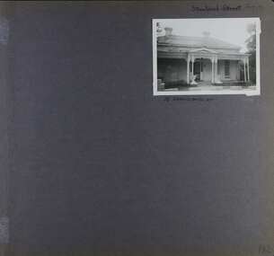
Album - Album page, Staniland Grove, Circa 1972
This album was created in approximately 1972 as part of a project by the Caulfield Historical Society to assist in identifying buildings worthy of preservation. The album is related to a Survey the Caulfield Historical Society developed in collaboration with the National Trust of Australia (Victoria) and Caulfield City Council to identify historic buildings within the City of Caulfield that warranted the protection of a National Trust Classification. Principal photographer thought to be Trevor Hart, member of Caulfield Historical Society. Most photographs were taken between 1966-1972 with a small number of photographs being older and from unknown sources. All photographs are black and white except where stated, with 386 photographs over 198 pages. 15 Staniland Grove is a contributory property to HO72 Elsternwick Estate and environs.Page 192 of Photograph Album with one photograph of a house on Staniland Grove.Handwritten: Staniland Street altered to Staniland Grove [top right] / 15 STANILAND ST [under photo] /192 [bottom right]trevor hart, chimneys, porch, villa residence, garden, verandah, 1890's, late victorian, decorative brackets, cast iron lacework, 1880's, slate roof, single storey, cast iron columns, cast iron frieze, elsternwick, boom period, triangulated pediment, coloured glass, mosaic tiling, complex tiled patterns, pots, italianate, staniland grove, rendered -
 Glen Eira Historical Society
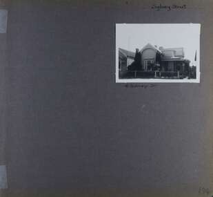
Album - Album page, Sydney Street, Circa 1972
This album was created in approximately 1972 as part of a project by the Caulfield Historical Society to assist in identifying buildings worthy of preservation. The album is related to a Survey the Caulfield Historical Society developed in collaboration with the National Trust of Australia (Victoria) and Caulfield City Council to identify historic buildings within the City of Caulfield that warranted the protection of a National Trust Classification. Principal photographer thought to be Trevor Hart, member of Caulfield Historical Society. Most photographs were taken between 1966-1972 with a small number of photographs being older and from unknown sources. All photographs are black and white except where stated, with 386 photographs over 198 pages. This house has been replaced according to Google image capture Feb 2019.Page 194 of Photograph Album with one photograph of an Edwardian house on Sydney Street, Murrumbeena.Handwritten: Sydney Street [top right] / 16 SYDNEY ST [under photo] / 194 [bottom right]trevor hart, chimneys, porch, garden, verandah, single storey, bull nose verandah, incised weatherboards, edwardian, fretwork, 1900's, return verandah, murrumbeena, sydney street, gardens -
 Glen Eira Historical Society
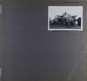
Album - Album page, Wanda Street, Circa 1972
This album was created in approximately 1972 as part of a project by the Caulfield Historical Society to assist in identifying buildings worthy of preservation. The album is related to a Survey the Caulfield Historical Society developed in collaboration with the National Trust of Australia (Victoria) and Caulfield City Council to identify historic buildings within the City of Caulfield that warranted the protection of a National Trust Classification. Principal photographer thought to be Trevor Hart, member of Caulfield Historical Society. Most photographs were taken between 1966-1972 with a small number of photographs being older and from unknown sources. All photographs are black and white except where stated, with 386 photographs over 198 pages. House still in place per Google image capture June 2019. It is Wanda Road, not street. Page 198 of Photograph Album with one photograph of a house on Wanda Street.Handwritten: Wanda Street [top right] / 19 WANDA STREET [under photo] / 198 [bottom right]trevor hart, porch, garden, verandah, single storey, return verandah, decorative brackets, wanda street, ridge capping, spire, protruding bays, decorative fretwork, queen anne style, queen anne, conical tower, wanda road, caulfield north -
 Glen Eira Historical Society
Photograph - CARNEGIE
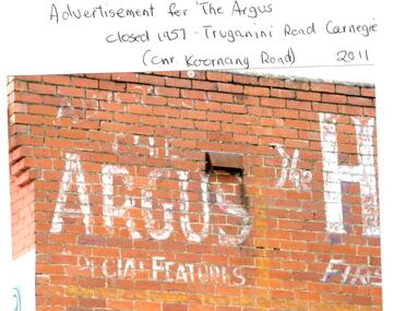
24 photographs relating to Carnegie plus 1 slide: 1/Two photographs, one of Koornang Road c.1920’s and one of flower shop rear of library, date unknown. 2/One photograph of Carnegie Post Office c. undated. 3/Two photographs Koornang Road, Carnegie and phone boxes, Carnegie, dated 1914. 4/Two photographs (the same) of an RSL Ball dated 15/08/1937. 5/17 black and white negative photos – reprinted, date unknown, of Carnegie Library, shop front opening Koornang Road. 6/Slide showing Koornang Road, Carnegie looking South. 7/6 photocopied postcards from Valentines Real Photo Series, in album owned by Mrs. Zoe Mason, collected and returned to Pam Speedy (daughter) 12 Wattle Grove, East Malvern, 15/03/1999. Photocopied pages from 1923 Sands and McDougalls included with some prints to give an idea of architecture and other retail trade. 8/Two photocopied prints of Carnegie Flood. 1946 – Koornang Road, shows shopkeepers in street at that time. 9/Two photographs of brick wall advertising the "Argus" newpaper, which closed in 1957. Photos taken in 2011 when building was exposed prior to rebuilding on site.koornang road, rosstown road, carnegie, shepparson street, carnegie library, carnegie post office, mcallister b., glen huntly, glenhuntly, phone boxes, memorial hall, bamfield m., tranmere avenue, carnegie railway station, stations, libraries, post offices, memorial hall carnegie, progress hall, carnegie community singing, social clubs, chadstone progress, newspapers, temminghoff robert, carnegie chamber of commerce, caulfield city council, rob’s chocolate box, rosstown, ross william murray, rosstown railway, elsternwick, oakleigh, city of caulfield, glen huntly road, glenhuntly road, grange road, carnegie primary school, primary schools, murrumbeena, neerim road, dandenong road, koornang park, lord reserve, rosanna street reserve, packer oval reserve, caulfield swim centre, holywood grove, mile end road, mcpherson avenue, munster avenue, rosstown hotel, leila road, methodist church, toolambool street, carnegie theatre, carnegie estate agency – sims and broadbent, woorayl street, estate agents, cowie j. mrs., confectioner, woodhouse e., stationer, mckay jno. a., mckay jonathon, small goods, perry w. b., chemists, kinsman e. h., newsagents, jones a. w., mckee wm., furniture stores, neil geo. m., grocer, truganini road, brick -
 Glen Eira Historical Society
Document - Melbourne and Metropolitan Board of Works
This file contains five items relating to Caulfield Council Visits with the Melbourne & Metropolitan Board of Works (MMBW) from 1919 to circa 1974: 1/A photo album containing photos from the MMBW ‘visit to the Headworks, Yan Yean Water Supply, Wallaby and Silvery Creeks’ from 28/02/1919 to 03/03/1919, attended by members of the Caulfield City Council. The album contains 13 original black-and-white photographs, 3 of which are of the council members. The album is accompanied by a report by Felicitie Campbell, written 11/2008, about these visits. 2/A publication from the MMBW documenting its review of operations for 1973-1974. The report contains information about water supply, sewerage and drainage infrastructure completed or in progress during this period including infrastructure in Caulfield, Ormond, Carnegie and Bentleigh. 3/A periodical feature from the MMBW titled ‘Living City’, issue no. 16, Spring/Summer 1974. Included in the article titled ‘Program’ is a notice that construction will continue on the Elster Creek drain from Thomas St. to Wheatley Road, McKinnon. The periodical also includes the names of commissioners W. R. Walters from Caulfield and G. R. Bricker from Moorabbin (back cover). 4/2 maps and 1 information booklet from the Thomson Project Open Day attended by Felicite and John Campbell as representatives of the Caulfield City Council. This was an annual MMBW open date. Date unknown. 5/Resarch notes by Kate Aldred about the photo album and Thomson Project Open Day booklet and their links to Felicite Campbell 01/04./2014.koornang road, draper street, hall street, centre road, brewers road, caulfield intercepting sewer, byron street, caulfield park, elster creek, caulfield, carnegie, ormond, bentleigh, thomas street, brighton east, wheatley road, mckinnon, city of caulfield, bricker g. r., walters w. r., caulfield city council, melbourne and metropolitan board of works, hall councillor, murray councillor, murphy councillor, wharington councillor, phillips councillor, blyth councillor, best robert sir, reid doctor, jowett mr., wooley mr., hindle mr., annual reports, water supply structures and establishments, sewerage and sanitation, sewerage establishments, drainage, town planning, business and finance, councillors, mayors, acqueducts, dams and reservoirs, creeks, waterfalls, rivers, construction sites, north road, north road pumping station, cities and towns, campbell felicitie -
 Glen Eira Historical Society
Album, Caulfield Historical Society Photograph Album 1972, 1972
This album was created in approximately 1972 as part of a project by the Caulfield Historical Society to assist in identifying buildings worthy of preservation. The album is related to a Survey the Caulfield Historical Society developed in collaboration with the National Trust of Australia (Victoria) and Caulfield City Council to identify historic buildings within the City of Caulfield that warranted the protection of a National Trust Classification. Principal photographer thought to be Trevor Hart, member of Caulfield Historical Society. Most photographs were taken between 1966-1972 with a small number of photographs being older and from unknown sources. All photographs are black and white except where stated.Photo album of buildings in Caulfield circa 1972 compiled alongside a project to assist National Trust Australia (Victoria) in identifying buildings worthy of preservation. All photos are black and white except where stated, with 386 photographs over 198 pages. Label on front is longstanding but not original or confirmed.caulfield, photographs, photo album, trevor hart, jenny o'donnell, jenny odonnell, caulfield historical society, glen eira historical society, carnegie, caulfield east, caulfield north, caulfield south, elsternwick, murrumbeena, st kilda east, houses, mansions, churches, schools, halls, shops, post offices, cinemas, town halls, hotels, banks, vicarages, bridges, gates, convents, bowling clubs, fire stations, roads and streets, caulfield historical album, 1970's, national trust of australia, city of caulfield, glen eira city council, national trust of australia (victoria) -
 Glen Eira Historical Society
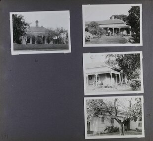
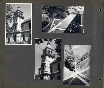
Album - Album page, Myoora, 405 Alma Road, Circa 1972
This photograph is part of the Caulfield Historical Album 1972. This album was created in approximately 1972 as part of a project by the Caulfield Historical Society to assist in identifying buildings worthy of preservation. The album is related to a Survey the Caulfield Historical Society developed in collaboration with the National Trust of Australia (Victoria) and Caulfield City Council to identify historic buildings within the City of Caulfield that warranted the protection of a National Trust Classification. Principal photographer thought to be Trevor Hart, member of Caulfield Historical Society. Most photographs were taken between 1966-1972 with a small number of photographs being older and from unknown sources. All photographs are black and white except where stated, with 386 photographs over 198 pages. Myoora - Victorian Heritage Register (VHR) Number H0490 https://vhd.heritagecouncil.vic.gov.au/places/275 Myoora, 405 Alma Road, North Caulfield, was designed by Reed, Henderson & Smart and can be attributed to Anketell Henderson. It was built in 1886 and 1887 for Thomas Christian, who had founded the fabled gold mine, the Day Dawn at Charters Towers. He never occupied the house although his widow lived there for some time. The house was subdivided into three and later six flats. Myoora was one of many large mansions on broad acres with gardens in Caulfield. Perhaps the grandest was Labassa. The mansions date from the 1850s through to the late 1890s. The siting of Myoora on a ridge influenced its planning and composition. A central hall and corridor along the ridge is entered from the centre of the more formal north facade. The entrance is marked by an elaborately detailed tower. A stair turret provides a second accent. The western end of the building is completed by a massively detailed chimney as the service wing. The south facade enjoyed an outlook to port phillip from a two-storey cast iron verandah. Bay windows, chimneys, the tower and the turret and minor details are brought together in a sophisticated asymmetrical composition. This is reflected in the planning. The asymmetry of Myoora pivoting on the tower is the most notable feature of the building. The walls are built of cement rendered brick. The cement render has not been painted. The roof is slate. The balconies and verandah are cast iron. The footings and cellar are bluestone. The architectural firm Reed, Henderson & Smart was very prominent in Victoria in the nineteenth century. Anketell Henderson was an eminent and well respected member of the profession. He worked successfully in London and interstate as well as in Victoria. They were better known for commercial and public buildings. Myoora is an important private commission. The style of Myoora is a combination of details from the Continental and English Renaissance through the boom style and the Queen Anne style. There is also an early influence from the American Romanesque style especially in the stair turret. The latter style was important at the turn of the century and Myoora is a significant precursor. Other buildings of a similar scale survive in Caulfield and elsewhere. Labassa, the most fabulous, is quite different stylistically as are most of the other comparable mansions.Page 7 of Photograph Album including four black and white photographs. Three photos are in a portrait orientation and placed diagonally across the page from the top left hand side to the bottom right hand side. One photograph in a landscape orientation is on the top right hand side of the page. Handwritten: 007 (bottom left hand corner)caulfield north, trevor hart, alma road, mansion, myoora, tower, thomas christian, 1880's, queen anne, cement rendered brick, unpainted, balconies, verandahs, anketell henderson, continental and english renaissance, american romanesque, views, cast iron work, reed henderson & smart, flats, gardens, asymmetrical style, slate roofs