Showing 8342 items matching "bridges"
-
 Lakes Entrance Historical Society
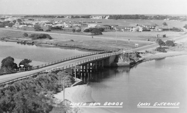
Photograph - North Arm bridge Lakes Entrance Victoria, Bulmer H D, 1945c
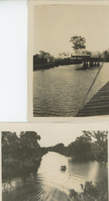
... Bridges ...Notes: Club Hotel spit has not yet been formed. Also Postcard 8.5 x 13.5Black and white photograph of the North Arm Bridge, It shows the reinforced concrete bridge over the North Arm, and a rear view of other notable buildings. In the background sand hummocks. Lakes Entrance Victoriabridges, topography, township -
 Orbost & District Historical Society
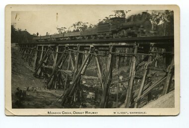
black and white photograph, Vogt. W.S, first half 20th century
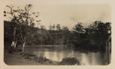
This 97km Bairnsdale to Orbost extension through rugged terrain was reputed to have been the most difficult rail project undertaken in Victoria. This wooden bridge was one of the unique railway bridges of the East Gippsland Railway line. Mundic Creek Bridge is of unique design because the line crosses at a very sharp angle. This bridge like many others on the line have "disappeared". This one, probably because of a bushfire.The Bairnsdale to Orbost rail line contains the most varied range Of timber & timber composite bridges on any Victorian line. This photograph is a record of that. A black / white photograph of a train on a wooden railway bridge at Mundic Creek.on front - Mundic Creek, Orbost Railway W.S.Vogt, Bairnsdalemundic-creek-bridge east-gippsland-railway -
 Phillip Island and District Historical Society Inc.
Photographs, Country Roads Board, Construction of 2nd Phillip Island Bridge 1966 - 1969, 1966 - 1969
Collection of Black & White photographs of the construction of the second Phillip Island Bridge by the Country Roads Board. Contractor John Holland & Co Pty. Ltd.Black & White photographs of the Construction of the Phillip Island 2nd Bridge in 1969 351-01: View from centre of suspension bridge. 351-02: Concreting Pier 8 351-03: Concreting Pier 8 351-04,05 & 06: Metal beams. 351-07: Driving sheet Piling. 351-08:Reinforcement in caisson (watertight structure)351-01: Country Roads Board Victoria, Aust. Negative No. 67-37 - Phillip Island Bridge Project. Shire of Bass 352-02: As above - Negative No. 67-38B 352-03: As above - Negative No. 57-38D. 352-04: Negative No. 67-223A. 352-05: Negative No. 67-223B 352-06: Negative No. 67-223D 352-07: As 352-01-03 plus Negative No. 67-312 352-08: As above - Negative No. 67-272.phillip island bridge (1969), country roads board, sasha stark -
 Orbost & District Historical Society
May 1900
This is a photograph of the original Orbost / Snowy River Bridge , a suspension bridge which opened in 1893. It has been taken when the Snowy River was in flood. It is similar to other photographs held in The State Library, Victoria. The Snowy River Mail and Tambo and Croajingolong Gazette Sat 12 Aug 1893 records the opening of this bridge as "the most important public event that has yet been commemorated in Eastern ......The Messrs McLeod, with whom the first settlement of this district is generally associated, took up their residence on the eastern bank of the Snowy River about the year 1841 or 42. The late Mr W. Roadknight and Mr T. T. Stirling took possession of the territory on the western side of the Snowy about 35 years ago. During the occupation of the country by cattle owners, very little progress was made in the way of roads and bridges, and except to the hardy and lexperienced bushman, it might have been generally regarded as inaccessible. About the year 1877, however, the late Mr James Robertson eldest son of Mr James Robertson, of Lochend farm, selected land now occupied by his father, about four miles from Orbost on the west bank of the river, Mr John Cameron visited the. district shortly after a .tour of inspection and returned later with his brothers, James and Alick Gameron, but found that during their absence Mr Ernest Watt had found his way on the scene and pegged out a selection, thus anticipating the advent of the Camerons by about 12 hours. We understand that a Mr Kidd, who selected the property now occupied by Mr W. J. Ross, at Pumpkin Point, was one of the earliest batch of settlors.........."This is a pictorial record of an early bridge across the Snowy River at Orbost.A black / white photograph of a suspension bridge with flood waters below the bridge.orbost-bridge suspension-bridge snowy-river -
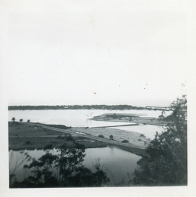
 Lakes Entrance Historical Society
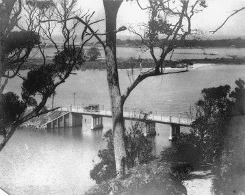
Photograph - North Arm bridge Lakes Entrance Victoria, 1920c
... Bridges ...Other photographs in album of this area dated 1928Black and white photograph of the North Arm Bridge, taken from Kalimna Heights looking towards the Entrance and Bullock Island. Bridge has no side rails, appears to be chain and wire between concrete posts. Sedan car passing over the bridge. The walking track to Kalimna Heights visible right foreground. Lakes Entrance Victoriabridges, waterways, transport -
 Kew Historical Society Inc
Photograph - Zig-Zag Bridge, 1924
Henry Beater Christian (1886-1962) , was a descendant of one of the earliest settler families in Kew. Employed at the Kew Asylum as a 'public servant', he was a skilled amateur photographer, photographing numerous scenes in Kew and on his travels around Victoria. The majority of his photographs date from 1916 to 1929. His finest photographs are housed in two photograph albums. Digital copy of a photograph from page 8 of the 47-page photograph album containing 261 gelatinous silver images, loaned by Diane Washfold with permission given to digitise and hold a copy in our collection. This photograph reveals how the photographer, Henry Christian, positioned himself to take the photograph from the angle in which he was interested. A skilled canoeist, an empty canoe is on the left bank that he apparently he used to access his vantage point. His subject, the Zig-Zag Bridge linked the grounds of the Yarra Bend and Kew Asylums. The wooden bridge was constructed in the 1870s and lasted through numerous floods until its destruction in 1929. A horizontal structure, the walkway was reached via a wooden staircase on the Studley Park end. The steps were requires due to the different levels of the banks on this stretch of the river. "Zig-Zag Bridge"henry beater christian (1886-1962), landscape photography, kew (vic.) — yarra river, christian-washfold collection, photograph albums, zig-zag bridge -
 Kew Historical Society Inc
Photograph - Zig-Zag Bridge, 1924
Henry Beater Christian (1886-1962) , was a descendant of one of the earliest settler families in Kew. Employed at the Kew Asylum as a 'public servant', he was a skilled amateur photographer, photographing numerous scenes in Kew and on his travels around Victoria. The majority of his photographs date from 1916 to 1929. His finest photographs are housed in two photograph albums. Digital copy of a photograph from page 8 of the 47-page photograph album containing 261 gelatinous silver images, loaned by Diane Washfold with permission given to digitise and hold a copy in our collection. This photograph reveals how the photographer, Henry Christian, positioned himself to take the photograph from the angle in which he was interested. A skilled canoeist, an empty canoe is on the left bank that he apparently he used to access his vantage point. His subject, the Zig-Zag Bridge linked the grounds of the Yarra Bend and Kew Asylums. The wooden bridge was constructed in the 1870s and lasted through numerous floods until its destruction in 1929. A horizontal structure, the walkway was reached via a wooden staircase on the Studley Park side. The steps were requires due to the different levels of the banks on this stretch of the river. "Zig-Zag Bridge"henry beater christian (1886-1962), landscape photography, kew (vic.) — yarra river, christian-washfold collection, photograph albums, zig-zag bridge -
 Marysville & District Historical Society
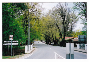
Photograph (Item) - Colour photograph, Travel Victoria, Unknown
A colour photograph of the F.J. Barton Bridge in Marysville in Victoria.A colour photograph of the F.J. Barton Bridge in Marysville in Victoria. The F.J. Barton Bridge was named after Frederick John Barton. The Barton Family were amongst Marysville's first pioneering families.f.j. barton bridge, f.j. barton, marysville, victoria, photograph -
 Marysville & District Historical Society
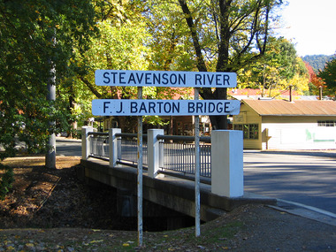
Photograph (Item) - Colour photograph, 09-2001
A colour photograph of the F.J. Barton Bridge in Marysville in Victoria.A colour photograph of the F.J. Barton Bridge in Marysville in Victoria. The F.J. Barton Bridge was named after Frederick John Barton. The Barton Family were amongst Marysville's first pioneering families.SEPT. 2001fj barton bridge, marysville, victoria, photograph, frederick john barton -
 Marysville & District Historical Society
Photograph (Item) - Colour photograph, Unknown
A colour photograph of the F.J. Barton Bridge in Marysville in Victoria.A colour photograph of the F.J. Barton Bridge in Marysville in Victoria. The F.J. Barton Bridge was named after Frederick John Barton. The Barton Family were amongst Marysville's first pioneering families.fj barton bridge, marysville, victoria, photograph, frederick john barton -
 Lakes Entrance Historical Society
Photograph - Bullock Island, Fraser Ian, 1920c
... Bridges ...Black and white photograph of Bullock Island, showing Prince's Highway from North Arm bridge, east end of Bullock Island and bridge, entrance to Bass Strait and sand dunes along Cunninghame Arm. Western end of Bullock Island bridge raised to allow small boats access to North Arm and Cunninghame Arm, became known as Humpy Bridge. Lakes Entrance Victoria islands, waterways, topography, bridges -
 Stawell Historical Society Inc
Archive - Books & Papers, Ken Hyslop, Campbells Bridge Back to 1991, 1991
Associated with Back to Campbells Bridge and writing of Campbells bridge development and Social History 1861 - 1991. By Ken HyslopRecords relating to Campbells Bridge back to 1991. Plus Back to sign in bookVisitors Booksocial history -
Glenelg Shire Council Cultural Collection
Photograph - Photograph - Portland scene, c. 1970
Photographic print of a rephotographed photograph. Image shows lower north slope Observatory Hill, fence along base, then wooden bridge over Salt Creek that drains into bay, near the Spit Portland.Front: 'Bridge over Portland drain' - green ink -
 Phillip Island and District Historical Society Inc.
Photograph, ?
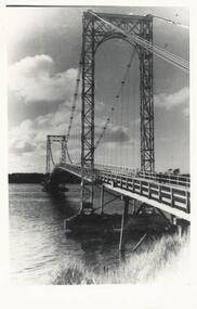
One of a collection of photographs purchased from Photo First, Thompson Avenue, Cowes, when it closed in June, 2014. The bridge was built in 1939 and opened in November 1940. Large Black & White photograph of Phillip Island Suspension Bridge, the first bridge from San Remo to Newhaven.phillip island suspention bridge, suspension bridge, photo first phillip island -
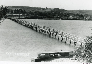 Lakes Entrance Historical Society
Photograph - Footbridge, Bulmer HD, 1940c
... Bridges ...1 black and white copy 13x18 has glue on back|1 copy tinted 9x14Black and white photograph of the foot bridge over the Cunninghame Arm. It shows a concrete wall at the edge of lake in foreground, two light poles on the bridge buildings on Esplanade and Myer Street. Lakes Entrance VictoriaThe Footbridge Lakes Entrancebridges, waterways, township -
 Sunbury Family History and Heritage Society Inc.
Photograph, Rosa McCall, Old Broadmeadows Township, 1949
... Bridges ...The small town in the photograph is the former Broadmeadows Township (now part of Westmeadows). It was situated on the Old Sydney Road (Mickleham Road) and 2 miles east of the Broadmeadows Station. The stone bridge in the foreground spans the Moonee Ponds Creek and Fawkner Street is the road, which leads southwards to Gladstone Park and Tullamarine. The little building was a lolly shop that Mrs. Ethel Mitchell owned and ran for many years.Until 1869, before Sydney Road was finally opened, travellers on their way to Sydney would pass through the Broadmeadows Township.A copy of a non-digital black and white photograph of a road way with a bridge in the foreground leading to a small settlement. Small building with a pitched roof and a verandah is on the RHS of the image and the road leading out of the town is bordered with an avenue of pine trees.old broadmeadows township, fawkner street, moonee ponds creek, westmeadows, bridges -
 Orbost & District Historical Society
photograph, first half of 20th century prior to 1976
Purchased from Orbost Op shop several years ago. Original owner unknown. This bridge over the Snowy River was opened on July 4 1922. It was constructed in 1922 alongside the previous suspension bridge. Its building was a combined effort of the Victorian Railways and the Country Roads Board at a cost of 35,000 pounds. It was replaced in 1976 by the present bridge after several major floods.This bridge was replaced in 1976 after several major floods.A wooden framed photograph of the second Snowy River bridge at Orbost.photograph snowy-river-bridge -
Lakes Entrance Historical Society
Book, Davidson, Rachael, The Nicholson River Railway Bridge, 2004
... Bridges ...Research, interpretation and management recommendations for the Nicholson River Railway Bridge, East Gippsland, Victoria, by a Forestec student.bridges, transport -
 Lakes Entrance Historical Society
Photograph - Swing Bridge Sale Victoria
... Bridges ...Also another black and white photograph of Thompson River 05222.1 9 x 6 cmBlack and white photograph of Sale Swing bridge which is open on Thompson River south of Sale Victoriawaterways, bridges -
 Clunes Museum
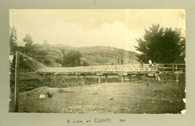
Photograph, CIRCA 1912
... bridges ...PHOTOGRAPH OF BRIDGE TO STEPS AT LOWER FRASER STREET, CLUNES.A VIEW OF CLUNES.local history, photography, photographs, bridges -
 Sunshine and District Historical Society Incorporated
Photographs (1928), 'QUARTER MILE' BRIDGE Construction, 1928
One man lost his life during the building of this bridge. The bridge was constructed by the Victorian Railways between 1927 to 1929 to carry a new double track goods line. This enabled trains from all parts of the state except Gippsland to have direct access to the Tottenham marshalling and sorting yards. These yards were constructed in the 1920's to relieve congestion in the Melbourne Yard near Spencer Street station. The congestion was being caused by the construction of suburban passenger platforms associated with the electrification of the suburban railway network. Initially the bridge was for goods trains but during the Second World War it was also used by troop trains. When the standard gauge line was built in 1962 all trains to Albury and Sydney have used this route, thus avoiding travelling through Essendon and Pascoe Vale on the suburban tracks. The standard gauge track across the bridge took the place of one of the broad gauge tracks so broad gauge trains crossing the bridge in either direction have to now use the same track. The bridge is 1,257 feet (383.13 metres) long and 180 feet (54.86 metres) above the water level. It is just 63 feet (19.2 metres) short of a quarter mile in length between abutments. There is a similar bridge on the same railway line crossing the Moonee Ponds Creek between Gowenbrae and Glenroy, however it is smaller at 1060 feet (323.08 metres) length and 115 feet (35.05) height.The bridge is now Victorian Heritage Registered under Number: H1197, and Heritage Overlay Numbers HO5, and HO107. On the Heritage Register it is named RAIL BRIDGE (ALBION VIADUCT). According to the Heritage Report the bridge is scientifically and architecturally important because of its large size, and because of the cost effective design features such as two girders per span (one for each track), the K bracing in the towers, and the broad flange beams as columns. When it was being built it was the largest trestle bridge in Australia, and until the Sydney Harbour bridge was constructed it was the highest railway bridge.Five B&W yellowing photos showing stages of construction of the Maribyrnong River Viaduct known as the Trestle Bridge but mainly known locally as the QUARTER MILE BRIDGE. It is a railway only bridge which runs over the Maribyrnong River between Sunshine North and Keilor East. A sixth image, which is not part of this set of photos, is included to show what the completed bridge looks like. -
 Lakes Entrance Historical Society
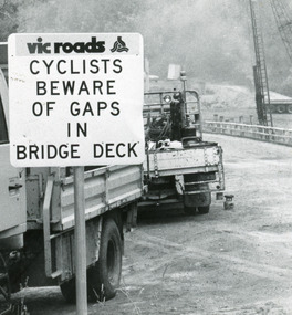
Photograph, Lakes Post Newspaper, 1991
... Bridges ...Date made January 1991Black and white photograph taken when work commenced on the construction of the new concrete bridge on the Princes Highway, Toorloo Arm, near Lakes Entrance. Road works in distance, crane beside present bridge, Vicroads warning sign to cyclists in foreground. Toorloo Arm Victoriabridges, waterways -
 Phillip Island and District Historical Society Inc.
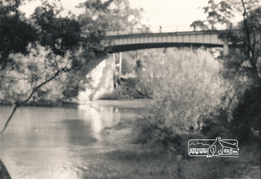
Photograph, Suspension Bridge, 1950's
First Suspension Bridge built 1940 between Newhaven & San Remo. Bridge opened by Hon. Albert Dunstan, Premier of Victoria. Photograph taken from San RemoBlack & White photograph of Suspension Bridge between Newhaven & San Remolocal history, photographs, film civil engineering, bridge, black & white photograph, jack jenner, phillip island bridge -
 Lakes Entrance Historical Society
Photograph, 2012
... Bridges ...Date made December 2012Colour photograph of the railway bridge over Boggy Creek at Nowa Nowa. Bridge is built on combination of solid concrete piers, timber trestle piers on concrete to flood level, and timber piers. Nowa Nowa Victoriabridges, waterways, transport -
 Eltham District Historical Society Inc
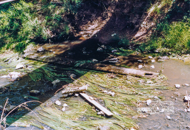
Photograph, Cross beam from old timber Main Road bridge over the Diamond Creek, 1992, 1992
... bridges ...Two colour photographs of old cross beam from original Main Road trestle bridge lying in creek bed. It is downstream from the current re-structured bridgebridges, diamond creek, main road, eltham south -
 Phillip Island and District Historical Society Inc.
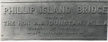
Photograph, 29/11/1940
One of a collection of over 400 photographs in an album commenced in 1960 and presented to the Phillip Island & Westernport Historical Society by the Shire of Phillip IslandPhotograph of the Bronze Plaque on the first Phillip Island Bridge showing wording clearly. 29/11/1940Phillip Island Bridge opened by The Hon A. A. Dunstan M. L. A. Premier of Victoria 29th November 1940.local history, photography, photographs, bronze plaque on first phillip island bridge, black & white photograph, phillip island bridge, the hon. a. a. dunstan. mla, john jenner, bryant west -
Eltham District Historical Society Inc
Photograph, Diamond Creek floods 1953, 1953
... bridges ...Three photographs of Diamond Creek in flood 21/10/1953 showing concrete bridge, Eltham South, Diamond Street bridge and Glen Park bridgediamond creek, floods, eltham, bridges, main road, wattletree road, diamond street, glen park -
 Eltham District Historical Society Inc
Photograph, Russell Yeoman, Warrandyte Bridge, c.1970, 1970c
... bridges ...Black and white photograph of Warrandyte Bridge over Yarra River c.1970warrandyte, yarra river, bridges -
 Whitehorse Historical Society Inc.
Photograph, Quarry Road Mitcham, 2006
... bridges ...Coloured photo of Guarry Road bridge near boundary of Whitehorse and Manningham municipalities.quarry road, mitcham, bridges -
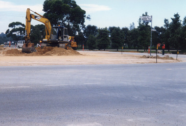 Lakes Entrance Historical Society
Photograph, 1999
... Bridges ...Date made January 1999 - June 2000Colour photograph of North Arm bridge under construction. Lakes Entrance Victoriabridges, waterways, public works