Showing 537 items
matching canterbury shops
-
 Canterbury History Group
Pamphlet - Cookery Highlights, 1/12/1948 12:00:00 AM
Photocopy of a recipe booklet produced by the Parents' Association of the Methodist Church, Highfield Road, Canterbury. The booklet has advertisements for many Canterbury businesses and was the property of C.P.Holt (incomplete).canterbury, highfield road, methodist church, shops, recipes, holt.c.p. -
Surrey Hills Historical Society Collection
Work on paper - Ephemera, H Bowley, Printer, Canterbury, Theatre program - Princess Ju Ju, 12 July 1916, Sep-31
William Lock lived at 9 Suffolk Road, Surrey Hills. Brown-coloured bi-fold paper program with one corner cut off. This does not diminish the information. Includes a cast list and synopsis of the three acts.Complimentary (underlined)freemason's hall, operetta, princess ju ju, surrey hills operatic society, holy trinity church, picardy players, hepworth, miss franklin, webb's confectionery shop, entertainment, fundraising, musical events and activities, miss horn, mr h brett, mr alan abery, mr o danvers, mr g duncan, mr j chapman, mr woffinden, mr hardman, miss jean gordon, miss morrison, mr latimer, miss franklin hepworth -
 Ringwood and District Historical Society
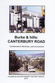
Book, Burke & Hills: Canterbury Road Camberwell to Montrose, by Heathmont History Group - 2014
Soft cover book of 40 pages with spiral wire spine. Compilation of images and descriptive timeline of the geology, geography and European settlement history of Canterbury Road.Soon after beginning at Burke Road Camberwell, Canterbury Road moves into the gentle hills of Canterbury, then on to Surrey Hills, Box Hill and Forest Hill. Further along past these three "hills" come three "monts" - Vermont, Heathmont and at its other end, Montrose, by then in the foothills of the Dandenongs. Grand homes and churches at one end, major and minor shopping centres along the 25km, factories now where farms were, big box stores, fast food outlets, train stations, resrvoir, traffic, residential stretches, modern apartment blocks, parklands, child-minding centres, sporting ovals, a sewage farm, hotels, quarries, commercial developments, plant nurseries, a golf course, bridges, memorials, Asian food shops, telecommunication towers, bushland, creeks, crossroads, traffic lights, mansions, orchards, swamps ... Delaneys Road, renamed Canterbury Road after a 19th century Victorian Governor, is a fascinating study in land use and history as suburban Melbourne has continually diversified and pushed outwards. Compiled by Heathmont History Group, Rita James, Les Prato, Betty Colbert, Jeff Leipold, Gerry Robinson (convenor). -
Canterbury History Group
Article, Duck, Siobhan, Sullivans shop for sale, 4/02/2002 12:00:00 AM
Article from the Progress Leader for the auction on 23 February 2002 of the shop used in the television series "The Sullivans", includes a coloured photograph of the front of the shop.canterbury, matlock street, the sullivans, general stores, loyal> helen -
Canterbury History Group
Document - Comments on Boroondara Thematic Environmental History Draft document, Canterbury History Group, 1/08/2011 12:00:00 AM
... Comments by some concerned members of the Canterbury ...Comments by some concerned members of the Canterbury community regarding issues relating to Canterbury resulting from a careful study of the draft consultation document prepared for the City of Boroondara.canterbury, visions of a village, education, libraries, stationmasters house, petrol stations, canterbury road shopping centre, maling road shopping centre, theatres, police stations, canterbury gardens, railways -
 Ringwood and District Historical Society
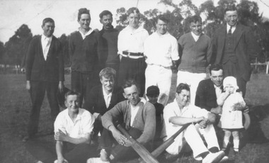
Photograph, First Heathmont Cricket Club in 1922 (social)
Written on back of photograph, "First Heathmont Cricket Club. Taken on oval on the corner of Canterbury and Heathmont Roads, Lisgoold St side. Shops now occupy this area. Back row: F. Pump, H. Pump, E. Nobbs, W. Pump, S. Wieland, B. Godfrey, Mr. F. Wieland, President. Front row: G. Pump, E. Pump, L. Miller, D. Sharp, N. Wieland, F. Clota, D. Sharp. See 'Mail' 7/10/1965". -
Canterbury History Group
Photograph - J. Weymouth Ironmonger, c1910
J. Weymouth Ironmonger, 245 Canterbury Road, established 1888. At the right of the photograph part of Miss Tregallas' drapery shop is visible c 1910. black and white photographcanterbury, canterbury road, j. weymouth ironmonger, miss tregallas draper -
 Ringwood and District Historical Society
Document - Research Notes, Richard Carter, Land Subdivisions in Ringwood 1890-1950
Handwritten table listing main local pre-1950s subdivisions in the Ringwood area, with estate names, streets, number of allotments for sale, and where known, vendor agent, LP (Lodged Plan) title registration number, and auction/sale date, some with sale price.Pg1 RINGWOOD STATION ESTATE LP3070 (Year?) Station Street, William Street (now Kendall Street), Wantirna Road, Station Street Pg1 RINGWOOD TOWNSHIP ESTATE LP5577 (1913) Station Road (now Warrandyte Road), Pratt Street (part now Aird Street), Whitehorse Road Pg2 RINGWOOD ORCHARD ESTATE LP4315 (1914) Brysons Road, Hillcrest Road, Anzac Avenue, Sulva Road Pg3 RINGWOOD RAILWAY ESTATE LP7522 (1918) Whitehorse Road (now Mount Dandenong Road), Dublin Road, Freeman Street, Patterson Street, Bona Street Pg4 THE RINGWOOD ESTATE LP7578 (1919) Warrandyte Road, Hobart Street, Paxton Street, Arnold Street Pg5 GARDEN FARMS ESTATE (LP?) (1919) Canterbury Road, Armstrong Road, Bungalook Road, Orchard Road, Bayswater Road (now Mountain Highway) Pg6 THE RINGWOOD ESTATE (SECOND SUB-DIVISION) LP7604 (1919) Warrandyte Road, Tamar Street, Derwent Street, Mersey Street Pg7 RINGWOOD STATION ESTATE LP7703 (1919) Bedford Road, Williams Grove (now Lena Grove) Pg8 RINGWOOD TOWNSHIP ESTATE LP8198 (1919) Wantirna Road, Ellison Street, Haig Street, Greenwood Avenue Pg9 EASTFIELD ESTATE (LP?) (1920) Eastfield Road, Longview Road, Pleasant Rise, The Mount Pg10 ELECTRIC RAILWAY ESTATE RINGWOOD LP9473 (1922) Campbell Street, Myrtle Avenue, George Street (now Tudor Court), Henry Street (now Myrtle Avenue), Williams Grove (now Lena Grove) Pg11 RINGWOOD PARK ESTATE LP7884 (1922 - two stages) Wonga Road (now Loughnan Road), William Street, Andrew Street, Harrison Street Pg12 HEATHMONT STATION ESTATE LP11009 (Date? - after 1922) Lisgoold Street, Viviani Crescent, Balrour Avenue, Station Street (now part Heathmont Road and part Wainui Street) Pg13 RINGWOOD RAILWAY ESTATE LP10507 (1923) Whitehorse Road, Sherbrooke Avenue, Burwood Avenue, Bonview Avenue, Heatherbrae Avenue, Grant Crescent Pg14 GARDEN HOMES ESTATE (LP?) (1923) Mullum Road, The Centreway, Wattle Crescent (now Wattle Avenue) Reserve Crescent (now Reserve Road) Pg15 DUBLIN ROAD ESTATE LP11993 (1923) Alexandra Road, Vonadawn Avenue, Green Street, Wood Street, Howard Avenue, Bedford Road, Dublin Road Pg16 CARLINGA ESTATE RINGWOOD LP9620 (1923) Bourke Street, Bond Street, Ringwood Street Pg17 PRATT'S JUNCTION ESTATE (LP?) (1923) Junction Street, Georges Road, Oliver Street, Whitehorse Road Pg18 EAST RINGWOOD ESTATE LP10492 (1923) Bona Street, Patterson Street, Miller Grove, Fairview Avenue, Eastfield Road, Whitehorse Road (now Mount Dandenong Road) Pg19 COLEMAN'S HEATHMONT ESTATE LP9974 (1923) Canterbury Road, Bedford Road, Alvena Crescent, Coleman Street, Leonard Street (now Royal Avenue) Pg20 RINGWOOD HEIGHTS ESTATE LP10506 (1924) Whitehorse Road, Bonview Avenue, Grant Crescent, Hillcrest Avenue, Heatherbrae Avenue, Margaret Street, Mary Street Pg21 EAST RINGWOOD STATION ESTATE LP10551 (1924) Knaith Road, Wenwood Street, Lois Street, Victoria Street, Station Street (now Railway Avenue) Pg22 GRAND VIEW ESTATE LP11019 (1924) Whitehorse Road, Rupert Street, Herbert Street, Leonard Street Pg23 RINGWOOD RAILWAY ESTATE & RINGWOOD HEIGHTS ESTATE - FINAL SECTIONS LP10506 & LP10507 (1924) Whitehorse Road, Sherbrooke Avenue, Burwood Avenue, Bonview Avenue, Heatherbrae Avenue, Margaret Street, Mary Street, Grant Crescent Pg24 RINGWOOD EAST ELECTRIC STATION ESTATE (LP?) (1924) Railway Parade (now Patterrson Street), Federal Road, Howship Avenue (part now French Street), Dublin Road, Rosedale Crescent Pg25 BEDFORD PARK (now Ringwood Secondary College) (LP?) (1924) Bedford Road, Adams Street, Anderson Street, Joyce Street, Graham Road Pg26 CROWN JEWEL ESTATE LP11645 (Private sales after 1924) Mount Dandenong Road, Mirabel Avenue, Valda Avenue, Evon Avenue, Velma Grove Pg27 GRAND CENTRAL ESTATE LP10917 (1925) Heathmont Road, Great Ryrie Street, Douglas Street, Garden Street, Bellevue Avenue Pg28 RINGWOOD (unnamed estate - 1926) Nelson Street, Seymour Street, Whitehorse Road Pg29 EAST RINGWOOD RAILWAY STATION ESTATE (YEAR? - 25 shops 60 villas) Railway Avenue, Dublin Road, Lawrence Grove, Stanley Avenue, Knaith Road Pg30 CHARM VIEW ESTATE (LP?) (year? - after 1926) Canterbury Road, Heathmont Road, Dickasons Road, Bennjett Avenue, Orchid Street Pg31 SUNBEAM ESTATE LP12150 (Circa 1925) Govt Road (now Old Lilydale Road), Sunbeam Avenue, Holland Road, Everard Street (now Everard Road) Pg32 FAIRVIEW ESTATE EAST RINGWOOD LP10853 (Circa 1924) Eastfield Road, Patterson Street, Margaret Street (now Short Street) Pg33 EAST RINGWOOD TOWNSHIP ESTATE LP3025 (Circa 1924 - 35 allotments) Mount Dandenong Road, Grey Street, Eastfield Road Pg34 EAST RINGWOOD TOWNSHIP ESTATE LP3025 (Circa 1924 - 49 allotments) and STATE SCHOOL ESTATE (26 allotments) and EAST RINGWOOD STATION ESTATE (14 shop sites) Mount Dandenong Road, Grety Street, Dunn Street, Eastfield Road, King Street, Holland Road, Dublin Road, Patterson Street, Bona Street Pg35 EAST RINGWOOD CENTRAL ESTATE LP17004 (1948) Knaith Road, Shasta Avenue, Talofa Avenue, Russet Road, Dublin Road Pg36 WARE ESTATE LP43360 (1958) Ware Crescent, Davey Drive, Grey Road (now Grey Street), Mount Dandenong Road Pg37 Lot 57 Kendall Street LP3070 (1939) £75.0.0 Pg37 Lot 14 LP7346 (year?) £225 Pg37 Lot 8 WHITE HORSE ESTATE LP14010 (year?) Maroondah Hwy, Seymour Street £98.9.0 Pg37 Lots 4-14 incl. LP10902 (year?) £300 Pg37 Lots 69&70 LP2216 (1939) Bedford Road, Pitt Street £500 Pg37 Lots 60&70 LP2216 (year?) £460 Pg37 MOUNTAIN VIEW ESTATE LP10902 (1936) Lots 1&2, 19-22 Wantirna Road, Daisy Street £50 Pg38 RAILWAY STATION ESTATE RINGWOOD EAST LP7522 (1925) Lots 16 to 19 £250 Pg38 RINGWOOD PARK ESTATE (LP?) (1924) Lot 112 Munro Street £230 Pg38 RINGWOOD TOWNSHIP ESTATE (LP?) (1925) Lot 57 Wantirna Road £850 Pg38 ELECTRIC RAILWAY ESTATE LP9473 (1925) Lot 98 & 99 £180 (30/- foot) Pg38 ELECTRIC RAILWAY ESTATE LP9473 (year?) Lot 100 £233.12.6 incl improvements (£2.12.6 foot) Pg38 Lot 22&23 Bedford Road Heathmont (LP & year?) £675 incl improvements Pg39 Lot 9 Mullum Mullum Road LP8221 (1923) £150 Pg39 Lot 27 Haig Street LP8198 (1925) £825 Pg39 Lot 56 Haig Street cnr Wantirna Road LP8198 (1923) £171 Pg39 Lots 3 & 4 Loughnan Road LP9626 (192?) £147 Pg39 Lots 98 & 99 Myrtle Avenue LP9473 (1925) £180 Pg39 Lots 80 & 81 Myrtle Avenue LP9473 (1929) £150 Pg39 Lot 30 Sherbrooke Avenue LP10507 (1926) £700 incl improvements Pg40 Lot 10 (year?) LP7703 £750 Pg40 Lot 36 (year?) LP7522 £25 Pg40 Lot 38 Pitt Street LP2216 (year?) £350 Pg40 Lot 7 Dublin Road cnr Green Street LP11993 (year?) £300 -
Canterbury History Group
Photograph - Canterbury Road looking west along Maling Road
... Road Canterbury Road Maling Road Maling Road Shops photograph ...Looking west along Maling Road, photo taken from Canterbury Roadphotograph (proof)canterbury road, maling road, maling road shops -
Canterbury History Group
Photograph - Infill shops 145-147 Maling Road Canterbury, Jan Pigot, 2006
Infill shops between Tim's Bookshop (previously the Telephone Exchange) and the old Post Office, trading as K.C. Hair Design and Scent.canterbury, maling road, post office, telephone exchange, k.c. hair design, scent, tims bookshop, shops -
Canterbury History Group
Photograph - Interior view of staff in the shop No. 133 Maling Road, Jan Pigot, 27/03/1993 12:00:00 AM
... Canterbury Maling Road Shop Interiors Coloured photograph ...Coloured photograph of the staff in period costume in the milk bar at No. 133 Maling Roadcanterbury, maling road, shop interiors -
Canterbury History Group
Photograph - 122 and 120 Maling Road, Canterbury in 1993, Jan Pigot, 1993
... Canterbury Maling Road Antique shops Gift shops Palm trees ...Coloured photograph of Farren-Price and Antique Restoration shops on the south side of Maling Road. Both shops have been occupied since 1923 by varied businesses. No. 122 was the Commerical Bank from 1929-1942.canterbury, maling road, antique shops, gift shops, palm trees, hel> f and j, farren-price, canterbury mansions, banks, signs, streetscapes -
Canterbury History Group
Photograph - Old Timber House in Maling Road, Jan Pigot, 1992
... way for new shops and car park. Canterbury Maling Road Timber ...Part of a set of 8 coloured photographs taken by Jan Pigot to record the demolition of some buildings in Maling Road to make way for new shops and car park.Old timber house on corner of Scott Street and Maling Road 1992. canterbury, maling road, timber house, scott street, shopping centres -
 Whitehorse Historical Society Inc.
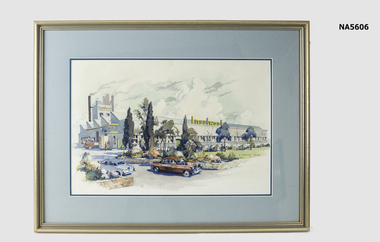
Painting - Water colour - Insulwool Factory
Insulwool Products Factory was on Whitehorse Road, Nunawading which closed in 1990 and now has Bunnings Warehouse. Insulwool became Boral Insulwool.Water colour painting of Insulwool Factory with landscape and garden. Has delivery truck and two cars in front. Gold frame with blue mount surrounds By C. Dudley Wood On back - the framing nook, 172 Canterbury Rd, Sth Blackburn, The Glen Shopping Centre, Glen WaverleyC. Dudley Wood & Insulwool Products Pty Ltdinsulwool factory, nunawading, c. dudley wood, painting -
Canterbury History Group
Photograph - Henry M. Smith Thrifty Link Hardware, Jan Pigot, 1989
Black and white photograph of exterior of the hardware shop of Henry M. Smith taken in 1989 by Jan Pigot.canterbury, canterbury road, henry m. smith, thrifty link hardware, hardware stores, lanes -
Canterbury History Group
Photograph - Henry M. Smith Thrifty Link Hardware, Jan Pigot, 1989
Black and white photograph of the interior of the hardware shop of Henry Smith looking towards the front door, taken in 1895 by Jan Pigot.canterbury, canterbury road, henry m. smith, thrifty link hardware, tools, hardware stores -
Canterbury History Group
Photograph - Group of Maling Road traders in period costume, Jan Pigot, 27/03/1993 12:00:00 AM
... Canterbury Maling Road Shop Fashion Coloured photograph ...Coloured photograph of a group of Maling Road Traders in period costume posing for a photograph in maling Roadcanterbury, maling road, shop, fashion -
Canterbury History Group
Photograph - Street view of the enamelled picture plaque of the former Canterbury Station, Jan Pigot, 2004
Coloured photograph of the street view of the enamelled picture plaque of the former Canterbury Station on the brick wall at No. 111 Maling Road, Canterburycanterbury, maling road, theatre place, shops, signs, plaques -
Canterbury History Group
Photograph - Street view of the enamelled picture plaque of the former Canterbury Station, Jan Pigot, 2004
Coloured photograph of the street view of the enamelled picture plaque of the former Canterbury Station on the brick wall of No. 111 Maling Road, Canterburycanterbury, maling road, theatre place, shops, signs, plaques -
Canterbury History Group
Photograph - Photograph of the enamelled picture plaque of the former Canterbury Station, Jan Pigot, 2004
Coloured photograph of the enamelled picture plaque of the former Canterbury Station. There are 2 copies of this photograph in the pocket.canterbury, maling road, theatre place, shops, signs, plaques -
 Ringwood and District Historical Society
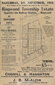
Flyer, Auction Sale Advertisements - Ringwood Township Estate, Ringwood, Victoria - 1913
Advertisements for auction sale of retail and residential blocks opposite the Ringwood Railway Station on Saturday, 8th November, 1913, showing subdivision layout, terms of sale, and summary of local features and services. Auction at 3 o'clock on the property by order of Mr. O.J. Pratt - 18 township lots, 27 villa blocks, also weatherboard butcher's shop with 5-roomed weatherboard house and good stabling, and 5-roomed new weatherboard villa. Subdivision includes Station Road (later Warrandyte Road), Pratt Street, and Whitehorse Road. Agents - Coghill & Haughton, 79 Swanston Street, Melbourne, Auburn & Canterbury, in conjunction with J.B. McAlpin, Opposite Railway Station, Ringwood. Additional 2 partially trimmed copies allotment maps on cardboard backing with handwritten sales notations. -
 Ringwood and District Historical Society
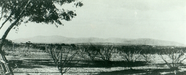
Photograph, Mansourah Picture Framing, Muller's Orchard, Corner of Canterbury Road and Dickasons Road in 1926, 1926
Peter Le Get found three framed photos of Heathmont view in a Heathmont Opportunity Shop. Previous owners unknown.Framed photograph of Mullers Orchard, Heathmont, Taken from the corner of Canterbury Road and Dickasons Road - - looking east, 1926.Mullers Orchard, Heathmont. -
 Canterbury History Group
Photograph - Demolition of Theatre in Maling Road, 1992
... to make way for new shops in Maling Road. Canterbury Maling Road ...The Maling Road theatre was badly damaged by fire in 1990 and demolished in 1993. Built as a Hoyts Theatre in 1942 it later became the New Canterbury Ballroom and in 1971 the Immanuel Revival Centre. Part of a set of 8 coloured photographs taken by Jan Pigot to record the demolition of some shops and the old theatre to make way for new shops in Maling Road.Colour photocanterbury, maling road, maling theatre, new canterbury ballroom, immanuel revival centre -
Canterbury History Group
Ephemera - Historical Walk Canterbury South of the Line and 3 letters, Pam Jellie et al, 1987/8
... Canterbury Mansions Maling Road Shops Eurobin "Cullymont" Wattle ...Walk organised by Canterbury History Group describing 10 sites and a map, 3 letters outlining funding for the walkBlue A4shett folded in 3 and 3 A4 typed letterscanterbury mansions, maling road shops, eurobin, "cullymont", wattle valley road, royal historical society of victoria -
Canterbury History Group
Ephemera, 1987 Australian Heritage Award, 1987
Maling Road shopping centre nominated by Camberwell Council for the 1987 Australian Heritage Awardsa newspaper cuttingcamberwell city news, canterbury, maling road, urban renewal planning scheme -
 Surrey Hills Historical Society Collection
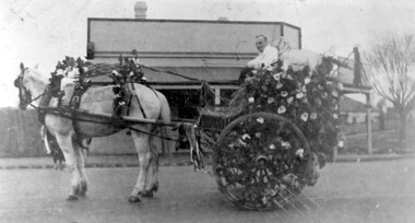
Photograph, Butcher's delivery cart belonging to Edward Tacey
Butcher’s Delivery Cart belonging to Edward Tacey, butcher of 629 Canterbury Road which has been decorated for Empire Day Celebrations of 1930s. Driver: Keith…….? Photographed at corner of Canterbury Road and Alexander Avenue, the Tacey shop was just to the left. The donor's grandfather was Edward's brother, William. Her father Albert Arthur took over the business from his brother Joseph, who took over from his uncle Edward.A black and white photograph of a decorated horse and cart. There is a man sitting in the cart. The cart is decorated with flowers and a cut out shape of a sheep.butchers, transport, carts and wagons, horse drawn vehicles, empire day, festivals and celebrations, edward tacey -
 Whitehorse Historical Society Inc.
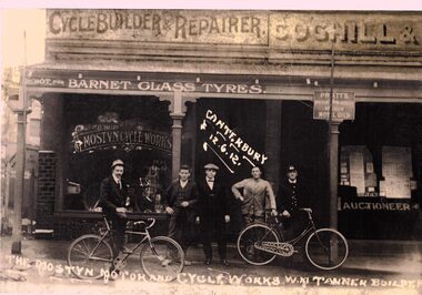
Photograph - B/W Photograph, William Mostyn Tanner
... Canterbury Road shop...William Tanner Bicycle Repairs Canterbury Road shop William ...william tanner, bicycle repairs, canterbury road shop