Showing 613 items matching "city square"
-
 Bendigo Historical Society Inc.
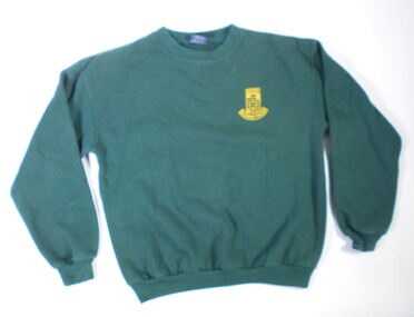
Textile - High School windcheater
Golden Square High School in the city of Bendigo, was established in temporary accommodation at Camp Hill Primary School in central Bendigo in 1960. With the completion of the new school's buildings, it moved to Golden Square in 1962, providing for Forms 1 to 6, now known as years 7 to 12. In 1978 it became a 7–10 school and was one of the original feeder schools to Bendigo Senior High School. In 1986, a Hearing Impaired Unit was established and in 1990 it underwent a name change to become Golden Square Secondary College. The Golden Square Secondary College campus closed on 28 November 2008. It merged with Kangaroo Flat and Flora Hill secondary colleges as part of the implementation of the Bendigo Education Plan. Its buildings were demolished. (Wikipedia https://en.wikipedia.org/wiki/Golden_Square_Secondary_College)Dark green windcheater with school emblem. Embroidered in gold. "Golden Square Secondary College". Brand label on the back "OZ Surf. Made in China.. Size Small." Washing instructions included.gssc, school uniform, gshs -
 Bendigo Historical Society Inc.
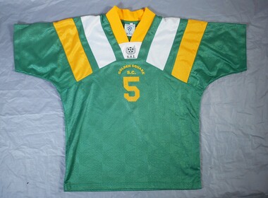
Textile - GSSC Sports top
Golden Square High School in the city of Bendigo, was established in temporary accommodation at Camp Hill Primary School in central Bendigo in 1960. With the completion of the new school's buildings, it moved to Golden Square in 1962, providing for Forms 1 to 6, now known as years 7 to 12. In 1978 it became a 7–10 school and was one of the original feeder schools to Bendigo Senior High School. In 1986, a Hearing Impaired Unit was established and in 1990 it underwent a name change to become Golden Square Secondary College. The Golden Square Secondary College campus closed on 28 November 2008. It merged with Kangaroo Flat and Flora Hill secondary colleges as part of the implementation of the Bendigo Education Plan. Its buildings were demolished. (Wikipedia https://en.wikipedia.org/wiki/Golden_Square_Secondary_College)Dark green short sleeved synthetic sports top with gold coloured V shaped collar. There are gold and white diagonal stripes on the collar. Symbol on the front of a soccer ball and decorative wreath with letters "SSI" and "Golden Square S C" The number % is in large print on the front and back. Made in Thailand.gssc, sports top -
 Bendigo Historical Society Inc.
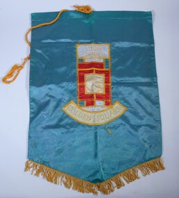
Textile - School Banner
Golden Square High School in the city of Bendigo, was established in temporary accommodation at Camp Hill Primary School in central Bendigo in 1960. With the completion of the new school's buildings, it moved to Golden Square in 1962, providing for Forms 1 to 6, now known as years 7 to 12. In 1978 it became a 7–10 school and was one of the original feeder schools to Bendigo Senior High School. In 1986, a Hearing Impaired Unit was established and in 1990 it underwent a name change to become Golden Square Secondary College. The Golden Square Secondary College campus closed on 28 November 2008. It merged with Kangaroo Flat and Flora Hill secondary colleges as part of the implementation of the Bendigo Education Plan. Its buildings were demolished. (Wikipedia https://en.wikipedia.org/wiki/Golden_Square_Secondary_College)Golden Square High School banner. A large green banner made of silk like material. The lower edge of the banner is fringed with gold coloured cord. A thick gold coloured hanging cord is attached to the top.gssc, sports top -
 Bendigo Historical Society Inc.
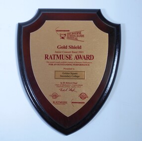
Award - School Sport Shields
Golden Square High School in the city of Bendigo, was established in temporary accommodation at Camp Hill Primary School in central Bendigo in 1960. With the completion of the new school's buildings, it moved to Golden Square in 1962, providing for Forms 1 to 6, now known as years 7 to 12. In 1978 it became a 7–10 school and was one of the original feeder schools to Bendigo Senior High School. In 1986, a Hearing Impaired Unit was established and in 1990 it underwent a name change to become Golden Square Secondary College. The Golden Square Secondary College campus closed on 28 November 2008. It merged with Kangaroo Flat and Flora Hill secondary colleges as part of the implementation of the Bendigo Education Plan. Its buildings were demolished. (Wikipedia https://en.wikipedia.org/wiki/Golden_Square_Secondary_College)Two wooden shields awarded to Golden Square Secondary College at the Melbourne School Bands Festival. Dark wood in the shape of a shield. a. Gold Shield awarded to the Junior Concert Band in 2001. TATMUSE AWARD for Outstanding Performance. Presented by Mr Richard Floyd. Sponsors represented by logos - Music Junction, Billy Hyde, RATMUSE (Music Publishers). Education Trust Vic. b. Yamaha Gold Award won by Golden Square Secondary College Intermediate Concert band 2003 at the Melbourne School Bands Festival. Presented to Symphonic Winds by Mr. K Waterworth. Award sponsored by Yamaha Music Australia, Billy Hyde Music. Blue border around a gold coloured shield.a. Sticker on the back of the Shield. "WINNING EDGE PRESENTATIONS Wholesale Trophy Framing and Giftware level 9 230 Collins Street Melbourne phone 9654 4911 Fax 9650 7106"gssc, sports top, music awards -
 Bendigo Historical Society Inc.
Article - MERLE HALL COLLECTION: ROSALIND PARK CREATIVE VILLAGE BENDIGO NEWSPAPER ARTICLES, 1997
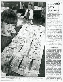
MERLE HALL COLLECTION: ROSALIND PARK CREATIVE VILLAGE BENDIGO NEWSPAPER ARTICLES 3858.9a Young boy holding a board of mosaic tiles probably at a workshop. Article begins: A unique mosaic pavement is to become part of the tapestry of the restored Rosalind Park. Students from three of Bendigo's central primary schools are taking part in the project. Photo Caption reads ART at work: preparing to create the unique mosaic pavement in Bendigo's Rosaling Park is eight year old St Killians Primary School student, David Nicholds. 3858.9b A newspaper coloured photo from the poppet head of two young people standing on and looking down on the mosaic at the lookout. Caption reads: Passing students take a keen interest in the new-look base of the Rosaling Park poppet head. The mosaic was created through an Art Bendigo project. LEAP workers helped install the five sections using stone tiles made by local primary school students. Depicting the saddle reef formations in the area the work has been designed and created by Bendigo artise Maery Hall. Picture: Peter Hyett. 3858.9c A photo from the poppet head lookout looking down at a worker with a broom, sweeping the mosaic. 3858.9d Two women crouching on the ground viewing the work done on the mosaic. One woman holds books and papers; in the far background over the car-park is the Sacred Heart Cathedral, the Bendigo Art Gallery and the Capital Theatre. 3858.9e Newspaper article along with coloured photo of the poppet head lookout in Bendigo's Rosalind Park. In the foreground are two young people arranging the mosaics. The article begins: Mosaic pavements began taking shape at the base of the Rosaling Park poppet head lookout yesterday. The pavement will cover about 130 square metres, in five sections, and have been designed as a memorial to Bendigo's mining history and traditions. 3858.9f Newspaper article July 29, 1997 entitled 'Bendigo Paving the Way' - photo of artist Maery Gabriel at the official opening of the heritage mosaic. Pictures: Tania Bond. Photo of Maery taken from the poppet head looking down on the mosaic. Als a smaller photo with details of the mosaic design. Opening paragraphs of the artical: Arts Bendigo and the City of Greater Bendigo are paving the way to an improved Rosalind Park with the official opening of the 'Bendigo Heritage Mosaic'. The mosaic is more than 100 square metres of decorated pavement sections surrounding the poppet head lookout at the park. The paving was designed by mosaic artist Mary Gabriel and depicts Bendigo's mining history and colour throughout. -
 Ballarat Tramway Museum
Photograph - Black & White copy photograph, "Shoppees Square Sturt Street looking South"
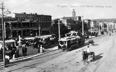
The photograph used in a postcard appears to be taken from the hotel balcony (Golden City) on the corner of Sturt and Dawson Streets, looking northeast. The tram is towing a former horse-drawn tram shortly after opening as no roof destination boxes on the tramcar in Sturt St. Many people promenading in the median strip with covered awnings over the seats, indicating summertime with two horse-drawn vehicles adjacent to the tram, one going either way in Surt St. south side, indicating traffic arrangements at the time. Has a Furniture Crockery store, Lesters Hotel and George Crocker Draper Hotel. Yields infomation about Sturt St and Shoppees Square c1905Black and white print with negative (N149) of an ESCo tram hauling a trailer.ballarat, tramcars, esco, sturt st, shoppee's square, trailers, horse trams, dawson st -
 Ballarat Tramway Museum
Postcard, "Shoppees Square Sturt Street looking South"
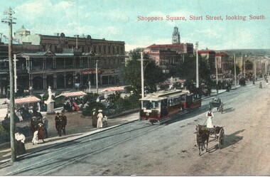
The photograph used in a postcard appears to be taken from the hotel balcony (Golden City) on the corner of Sturt and Dawson Streets, looking northeast. The tram is towing a former horse-drawn tram shortly after opening as no roof destination boxes on the tramcar in Sturt St. Many people promenading in the median strip with covered awnings over the seats, indicating summertime with two horse-drawn vehicles adjacent to the tram, one going either way in Surt St. south side, indicating traffic arrangements at the time. Has a Furniture Crockery store, Lesters Hotel and George Crocker Draper Hotel. Yields infomation about Sturt St and Shoppees Square c1905Postcard - coloured - Sturt St, card printed in Germany and number B377 10, with light brown ruled lines on rear.On rear is a letter to a lady in Adelaide with a 1d Victorian stampballarat, tramcars, esco, sturt st, shoppee's square, trailers, horse trams, dawson st -
 Kew Historical Society Inc
Document - Urban Planning Document, City of Kew, City of Kew : Minimum Size of Allotment Required, 1945-1955
A document outlining the relevant by-laws produced by the City Of Kew to regulate the minimum size of allotments in Barkers Road, Burke Road, Cotham Road, Glenferrie Road and Studley Park Road, as well as in other streets more generally. The by-laws specify the size of allotments in which single unit dwellings, attached houses and maisonettes, and flats could be built. In the ‘main streets’ a minimum land area for single unit dwellings was 8,100 square feet, with an average frontage of 60’ and a depth of 135’. In other streets this was reduced to an overall size of 6,250 square feet, with an average dimensions of 50’ x 125’. In specifying the land area required by flats, different sizes were regulated for the construction of between two and six flats. Six flats at the time when the regulations were passed must have been the upper limit permitted. Understanding the size of land listed in imperial measurements can be a challenge. Within Australia, the so-called quarter acre block was approximately 11,000 square feet. Those specified in the by-laws would appear to be smaller. The document was pasted on the reverse of a subdivision plan in the collection.This is a rare (undated) document produced by the City of Kew defining how subdivision within the municipality should occur. The document was created to constrain unbridled speculation in subdivisions in the various parts of Kew and East Kew.Undated typed document, issued by the City of Kew (1921-1994) indicating the minimum size of allotment required in Barkers Road, Burke Road, Cotham Road, Glenferrie Road and Studley Park Road. The document is mounted on board and waterstained. It was presumably used by a real estate agent. [Formerly catalogued as MAP.0066].city of kew - by-laws and regulations, subdivisions - kew - studley park -
 Tennis Australia
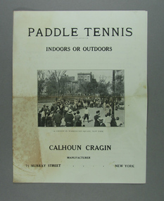
Instruction Manual, Circa 1923
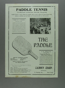
... in Washington Square, New York City. Materials: Paper, Ink... tennis game in Washington Square, New York City. Materials: Paper ...A four page instruction manual for the game of Paddle tennis (known in Australia as Bat Tennis). The cover features a photo image of boys and girls playing a bat tennis game in Washington Square, New York City. Materials: Paper, Inktennis -
 Tennis Australia
Poster, Advertisement, Circa 1923
... and girls playing a bat tennis game in Washington Square, New York... in Washington Square, New York City; an illustration of a 'paddle'; lawn ...A small poster promoting the game of Paddle tennis (known in Australia as Bat Tennis). It features a photo image of boys and girls playing a bat tennis game in Washington Square, New York City; an illustration of a 'paddle'; lawn tennis player endorsements; and media reports. Materials: Paper, Inktennis -
 Kew Historical Society Inc
Journal, Kewriosity : December 1986 / January 1987
Kew playgroups are great! [Highbury Grove; Woodlands Avenue] / p1. A gentle reminder about Kew's By-laws - Don't smoke your neighbour out / p1. Dates for December / p2. [Community] Notices / p2. Christmas services / p2. Commentary - The year that was / Cr Joe Ormando, Mayor of Kew p3. Good gardening - Trees: friends or foes? / Peter Davies p3. Profile - Cr James McKenzie / p4. Family Carols in Petrie Square / G Petrie p4. Would you like to be part of Kewriosity [Editorial committee] / p4. In Brief [Post Office complex classified; Don't forget to put your bottles out; Images of Kew; Kew Full Day-care Centre; School Holiday Program] / p5. Children's Services update [ Kew Children's Services Consultative Committee] / Krista Bell p5. Kew Community House [Courses for 1987; VCE (TOP) ; Pamphlet; Christmas Greetings; Christmas Beak-up] / p6. Overmantle returns to Villa Alba after 90 years / p6. Memories of a motor mechanic [Eric Buzza; Williams Motors; 1st Kew Scouts] / p7. Fine music all the way [3MBS] / p7. What's what in the playground? [Hays Paddock; Willsmere Park; Hyde Park; Eglinton Reserve] / p8. Having fun underwater [Kew Skindiving Club] / p8. Australia's fastest growing sport [East Kew Bowling Club] / G Petrie p8. Keeping you informed [Citizens Advice Bureau] / p8. Kew Citizens' Band [European] Tour Appeal / p8.Kewriosity was a local newsletter combining Kew Council and community news. It was published between November 1983 and June 1994, replacing an earlier Kewriosity [broad] Sheet (1979-84). In producing Kewriosity, Council aimed to provide a range of interesting and informative articles covering its deliberations and decision making, together with items of general interest and importance to the Kew community and information not generally available through daily media outlets.non-fictionKew playgroups are great! [Highbury Grove; Woodlands Avenue] / p1. A gentle reminder about Kew's By-laws - Don't smoke your neighbour out / p1. Dates for December / p2. [Community] Notices / p2. Christmas services / p2. Commentary - The year that was / Cr Joe Ormando, Mayor of Kew p3. Good gardening - Trees: friends or foes? / Peter Davies p3. Profile - Cr James McKenzie / p4. Family Carols in Petrie Square / G Petrie p4. Would you like to be part of Kewriosity [Editorial committee] / p4. In Brief [Post Office complex classified; Don't forget to put your bottles out; Images of Kew; Kew Full Day-care Centre; School Holiday Program] / p5. Children's Services update [ Kew Children's Services Consultative Committee] / Krista Bell p5. Kew Community House [Courses for 1987; VCE (TOP) ; Pamphlet; Christmas Greetings; Christmas Beak-up] / p6. Overmantle returns to Villa Alba after 90 years / p6. Memories of a motor mechanic [Eric Buzza; Williams Motors; 1st Kew Scouts] / p7. Fine music all the way [3MBS] / p7. What's what in the playground? [Hays Paddock; Willsmere Park; Hyde Park; Eglinton Reserve] / p8. Having fun underwater [Kew Skindiving Club] / p8. Australia's fastest growing sport [East Kew Bowling Club] / G Petrie p8. Keeping you informed [Citizens Advice Bureau] / p8. Kew Citizens' Band [European] Tour Appeal / p8. publications -- city of kew (vic.), kewriosity, council newsletters, community newsletters -
Kew Historical Society Inc
Journal, Kewriosity : May 1984
Bringing back the memories - in style [William Martin, Elder Care] / p1. Petrie Square / p1. Billabong Club / p2. Kew Garden Club / p2. Gone Bush! [Native Plant Group] / p2. Kew Bowling Club / p2. The Rheumatism and Arthritis Association Kew Self Help Group / p2. National Arthritis Week in Victoria / p2. Kew (Daytime) Garden Club / p2. Hockey [Kew Women's Hockey Club] / p2. Scouts / p2. May School Holiday Programme [Mobile New Trailer Games; Drop-in Centre; Kew Traffic School; Building or renovating; / p3. Kew Youth Resource Centre / p3. How Green is Our Valley - a continuing saga [S.E.C. Yarra Valley Powerlines] / p4. Mayoral Comment - Kew, its park and the SEC / Cr Jill O'Brien p5. Kew heritage [proposed heritage study] / p5. Philharmonic [Kew Philharmonic Orchestra] / p6. Kew Holiday Programme [Sacred Heart Church] / p6. The Gibbs Wathen Family re-union / p6. Yarra River Study - Dights' Falls to Burke Road / p6. Starlight Theatrical Company / p6. Kew Community House - 2nd Term Programme / p7. Public meeting - information sharing in Kew [Kewriosity Editorial Committee] / p7. Recyclotron / p7. Public Meeting - SEC Power Line / p8. Datelines [KPSA auction of pre-loved goods; A.L.P.; Guide Dogs Toastmasters Club, Kew - 100th meeting] / p8. Building? [regulations] / p8.Kewriosity was a local newsletter combining Kew Council and community news. It was published between November 1983 and June 1994, replacing an earlier Kewriosity [broad] Sheet (1979-84). In producing Kewriosity, Council aimed to provide a range of interesting and informative articles covering its deliberations and decision making, together with items of general interest and importance to the Kew community and information not generally available through daily media outlets.non-fictionBringing back the memories - in style [William Martin, Elder Care] / p1. Petrie Square / p1. Billabong Club / p2. Kew Garden Club / p2. Gone Bush! [Native Plant Group] / p2. Kew Bowling Club / p2. The Rheumatism and Arthritis Association Kew Self Help Group / p2. National Arthritis Week in Victoria / p2. Kew (Daytime) Garden Club / p2. Hockey [Kew Women's Hockey Club] / p2. Scouts / p2. May School Holiday Programme [Mobile New Trailer Games; Drop-in Centre; Kew Traffic School; Building or renovating; / p3. Kew Youth Resource Centre / p3. How Green is Our Valley - a continuing saga [S.E.C. Yarra Valley Powerlines] / p4. Mayoral Comment - Kew, its park and the SEC / Cr Jill O'Brien p5. Kew heritage [proposed heritage study] / p5. Philharmonic [Kew Philharmonic Orchestra] / p6. Kew Holiday Programme [Sacred Heart Church] / p6. The Gibbs Wathen Family re-union / p6. Yarra River Study - Dights' Falls to Burke Road / p6. Starlight Theatrical Company / p6. Kew Community House - 2nd Term Programme / p7. Public meeting - information sharing in Kew [Kewriosity Editorial Committee] / p7. Recyclotron / p7. Public Meeting - SEC Power Line / p8. Datelines [KPSA auction of pre-loved goods; A.L.P.; Guide Dogs Toastmasters Club, Kew - 100th meeting] / p8. Building? [regulations] / p8. publications -- city of kew (vic.), kewriosity, council newsletters, community newsletters -
 Kew Historical Society Inc
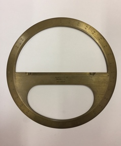
Equipment - Boxed Mathematical Instrument, Kilpatrick & Co, A Victorian cased brass full-circle protractor, 1853-1925
Kilpatrick & Co., Melbourne were active 1853-1925.A brass protractor, used in developing plans in the Engineer's Department of the City of KewCircular brass protractor in a square mahogany lidded case, retailed by Kilpatrick & Co., Melbourne. The protractor was used by staff in the Engineering Department of the former City of Kew. Handwritten inscription on label on lid:" J.R. Gray. G.P Russell,1951, Kew City Engineers used this".protractor, mathematical instrument, city of kew (engineering department) -
 Kew Historical Society Inc
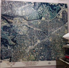
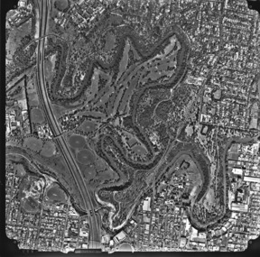
Photograph - Aerial Photograph, Division of Survey and Mapping, Department of Property and Services, City of Kew, Scale 1 : 3,000, 1989, 1989
The City of Kew was a local government area about 4 kilometres east of Melbourne, the state capital of Victoria, Australia, on the southeast bank of the Yarra River. The city covered an area of 14.56 square kilometres, and existed from 1860 until 1994.Very large aerial photograph of “City of Kew” Scale 1 : 3,000. 1989. “City of Kew” Scale 1 : 3,000. 1989. Photomosaic compiled by Division of Survey and Mapping, Department of Property and Services. © Crown (State of Victoria) Copyright 1990.city of kew, kew (vic.), aerial photography -
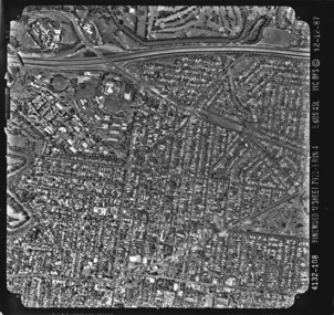
 Kew Historical Society Inc
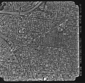
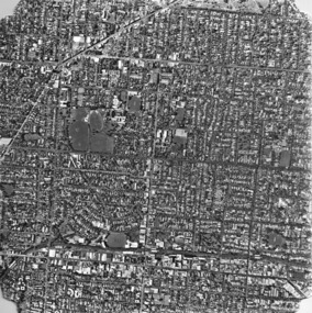
Photograph - Aerial photograph: City of Kew No.1/6, Department of Property & Services (Victoria), 12/12/1987
One of a series of six small square black and white aerial photographs of Kew taken and produced by the Victorian Department of Property Services.Aerial photographs, of which the Society has a number in its collection, allow researchers to identify changes in urban infrastructure and demographics over timeAerial photograph of a part of Kew, taken by photographers employed by the Victorian Department of Property and Services in December 1987.4132-106 Ringwood M'Sheet 7922-3 Run 4 5600'ASL Vic DPS © 12-12-87aerial photography, aerial photograph -- kew (vic.) -
 Kew Historical Society Inc
Photograph, Department of Property & Services (Victoria), City of Kew No.2/6, 12/12/1987
One of a series of six small square black and white aerial photographs of Kew taken and produced by the Victorian Department of Property Services.Aerial photographs, of which the Society has a number in its collection, allow researchers to identify changes in urban infrastructure and demographics over timeAerial photograph of a part of Kew, taken by photographers employed by the Victorian Department of Property and Services in December 1987.aerial photograph - kew -
 Kew Historical Society Inc
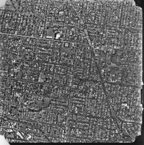
Photograph, Department of Property & Services (Victoria), City of Kew No.3/6, 12/12/1987
One of a series of six small square black and white aerial photographs of Kew taken and produced by the Victorian Department of Property Services.Aerial photographs, of which the Society has a number in its collection, allow researchers to identify changes in urban infrastructure and demographics over timeAerial photograph of a part of Kew, taken by photographers employed by the Victorian Department of Property and Services in December 1987.aerial photograph - kew, aerial photographs -
 Kew Historical Society Inc
Photograph, Department of Property & Services (Victoria), City of Kew No.4/6, 12/12/1987
One of a series of six small square black and white aerial photographs of Kew taken and produced by the Victorian Department of Property Services.Aerial photographs, of which the Society has a number in its collection, allow researchers to identify changes in urban infrastructure and demographics over timeAerial photograph of a part of Kew, taken by photographers employed by the Victorian Department of Property and Services in December 1987.aerial photograph - kew, aerial photographs -
 Kew Historical Society Inc
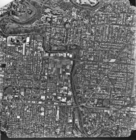
Photograph, Department of Property & Services (Victoria), City of Kew, No.5/6, 12/12/1987
One of a series of six small square black and white aerial photographs of Kew taken and produced by the Victorian Department of Property Services.Aerial photographs, of which the Society has a number in its collection, allow researchers to identify changes in urban infrastructure and demographics over timeAerial photograph of a part of Kew, taken by photographers employed by the Victorian Department of Property and Services in December 1987.aerial photograph - kew, aerial photographs -
 Kew Historical Society Inc
Photograph, Department of Property & Services (Victoria), City of Kew, No.6/6, 12/12/1987
One of a series of six small square black and white aerial photographs of Kew taken and produced by the Victorian Department of Property Services.Aerial photographs, of which the Society has a number in its collection, allow researchers to identify changes in urban infrastructure and demographics over timeAerial photograph of a part of Kew, taken by photographers employed by the Victorian Department of Property and Services in December 1987.4312-108 Ringwood M'Sheet 7922-3 Run 4 5600'ASL Vic DPS © 12-12-87aerial photograph - kew, aerial photographs -
Glen Eira City Council History and Heritage Collection
Book, 2015 ANZAC Centenary Poppies Community Project Book, 2015
... This large, black book is embossed with the square logo... in a commemorative book. This large, black book is embossed with the square ...The 2015 ANZAC Centenary Poppies community project was run by Glen Eira City Council, community artists and the Glen Eira community. Glen Eira Council encouraged community involvement by inviting the community to handmake poppies (knitted, crocheted, felted or crafted, no more than 15cm in diameter) to be included in a display in the Town Hall’s gallery from April the 8th. The Poppies Community Project Display will be held from 8th April - 17th May 2015 in the Gallery Annexe at Glen Eira Town Hall, with the hundreds of poppies arranged and linked by artist Emma Davies. The display was accompanied by a display of war memorabilia and artefacts, and visitors were invited to record their own dedication in a commemorative book.This large, black book is embossed with the square logo for the City of Glen Eira on the front. It contains tributes and dedications made by members of the community as part of the 2015 ANZAC Centenary Poppies community project under the headings "Date / Name / Dedication". The object also includes an unattached handwritten letter, and a handwritten label attached to one dedication. The dedication entries are dated from 10/04/2015 to 17/05/2015. -
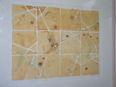 Brimbank City Council Art Collection
Screenprint, Chistine Dennis, Pattern Piece, 1985
Local artist, involved in Sunshine Art Advisory Committee.Watercolour pattern piece made by ochre wash over a heavy card stencil, then each square developed as panel. -
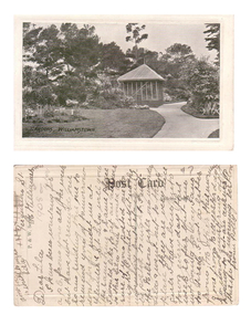 Williamstown Botanic Gardens- Hobsons Bay City Council
Postcard – Williamstown Botanic Gardens, c1900-1920
The original postcards in this series (2013.002 to 2013.018) were generously loaned to Williamstown Botanic Gardens by a private collector for copying. The postcards are evidence of the interest the gardens held as a subject for postcard publishers. The text and images provide a snapshot into fashions, social interests and concerns of the time. The professionally produced images provide a pictorial history of Gardens including changing planting styles, various structures and features of the Gardens eg the aviary, cannons, the fountain, the second Curator’s Lodge and gates. The images offer an opportunity to compare garden vistas with the present day. This card is a rare image of the original aviary built in the Gardens in 1892. The card also demonstrates how postcards were used as a method of contact in contrast to the contemporary use as souvenirs. The writer of the card, Polly, is anxious to receive a return postcard from Lila, writing that a reply should be sent that night. A black and white scene of a curving path with a square looking building at the centre. The 1894 MMBW plan shows that the building was triangular. The building is solid at ground level with the appearance of long vertical columns. The roof is light coloured and hip shaped with a finial at the apex. There is a garden set in the lawn on the left side of the image, shrubs and a palm at the left front corner of the building and tall trees in the background. The building is an aviary, which was built in north east section of the Gardens during 1892. The date of its removal is unknown. Front: ‘GARDENS, WILLIAMSTOWN’. Reverse: Centre top: ‘Post Card’; Vertical on left side: ‘P. & W. Series’; Right side ‘Address Only’. The card is addressed to Lila of ‘Ferguson St, N Williamstown’ from Polly. In pencil ‘1908 or later’ (believed to be inserted by the vendor of the card).postcard, gardens, post-card, williamstown-botanic-gardens, hobsons-bay-city-council, garden-path, aviary, 1908 -
 Surrey Hills Historical Society Collection
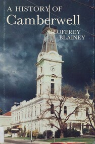
Book, A history of Camberwell, 1980
In 1964 Camberwell City Council commissioned Professor Geoffrey Blainey to first write this history. Since that time, many changes have taken place and therefore the Council asked Professor Blainey to bring the book up to date. Bibliography, includes index. The author presents a century of pioneering development and endeavours. He has traced the coming of the wood-cutters and the farmers, the transition from rectangular paddocks to a grid of roads and streets, the growth from shire to borough, town and city, the filling up of thirteen squares miles into residential suburbia - in successive waves of invasion, along new transport routes - including the Outer Circle Railway. Substantial chapters cover the War Years and the progress of Camberwell since the 1960s have also been included in this edition. 134p; ill;camberwell, victoria, market gardens, tolls, railways, mayors, boroondara road board, borondara shire, councillors, (mr) (prof) geoffrey blainey -
 City of Greater Bendigo - Civic Collection
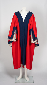
Ceremonial object - Robe, Blashki & Sons, c. 1990's
Red loose fitting ceremonial robe with contrasting broad band of blue fabric on lapel and collar. Square cut sleeves lined with cream fabric. Blashki & Sonsblashki & sons, city of greater bendigo ceremonial item -
 City of Greater Bendigo - Civic Collection
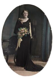
Photograph - Portrait, Vincent Kelly, Mrs J.A. Michelsen Mayoress 1935 -36, c. 1936
Prior to the election of female Councillors and Mayors from the 1960’s onwards the Mayoress role was one of the few ways women could be active in civic life. Mayoresses made important contributions to their local communities through their charity work and as ambassadors for their region on a state and at times, international level. They also undertook some Mayoral duties on occasions when the Mayor was unavailable. Annie Irene Michelsen (nee Tussup) born Huntly (1870-1955). Mayoress 1926/1927, 1935/1936, 1942/1943. Wife of Cr John Andrew Michelsen OBE. Pioneer in the field of social work and regarded as a woman of tremendous vitality and versatility. Known as an outstanding horse woman and breeder of standardbreds for harness racing. Member numerous sporting clubs and foundation president of the Bendigo Nurses Association. Framed, oval photographic studio portrait. Hand coloured detail. Mrs. Michelsen wore a gown of black crepe eros, cut to mould the figure and fall into a train at the back. A cascade eflect of gold lame from one shoulder to the hem in front gave graceful movement to the front of the gown, and wing draperies lined with gold lame were shirred to the shoulders of the square neckline. She wore a shoulder spray of golden orchids and carried a bouquet of old gold roses and golden leaves (1). The Argus (Melbourne, Vic. : 1848 - 1957) Wed 3 Jun 1936 annie tussup, mayoress michelsen, mayor michelsen, vincent kelly photographer, city of bendigo, city of greater bendigo portraits -
 City of Greater Bendigo - Civic Collection
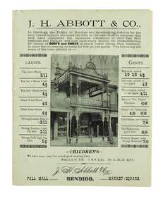
Flyer, Bolton Brothers Printers, J.H. Abbott & Co, c 1880
In 1867 J.H. Abbott established the New Times Boot Market & Factory in Pall Mall, Sandhurst. In 1867, his wife Anne took over running the shop which was located next to the Bendigo Arcade near Williamson Street and was successful in creating a successful business. In 1876, the leather business of T. Baulderstone was purchased, and operations were further expanded later by the acquisition of the Edinburgh Tannery at Sheepwash Creek, and The Edinburgh Leather & Grindery warehouse in Bull Street, Sandhurst. In 1889, Joseph Abbott passed all interests in the business to his son, who shared the same name, in partnership with an adopted son, Richard Hartley Smith Abbott. The business continued trading under the name J. H. Abbott & Co. A number of branches of the business had been established in the early 1900s. In 1959 the Pall Mall business relocated to 291 Hargreaves Street. The whole business was soon after consolidated and conducted from the Market Square branch (Lyttleton Terrace) as the Abbott Supply Company. Harold Abbott, the last of the family to work in the business, died in 1979. In 1980 the business shifted to a new purpose-built store and warehouse on the corner of Abel & Deborah Streets, Bendigo. Sandhurst Trustees administered the business from 1979 until its sale in 1986. He was elected to the Sandhurst Borough Council and in 1860 became chairman of the municipality.Two single colour printed gatefold flyer on green paper advertising J.H. Abbott and Co.'s boot and shoe store on Pall Mall Bendigo. Contains information on products and the fitting services provided in store for customers. chairman of sandhurst borough, anne abbott, city of greater bendigo commerce -
 City of Greater Bendigo - Civic Collection
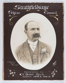
Photograph - Portrait of Councillor Keck, W H Robinson, c 1913
The district of Strathfieldsaye was proclaimed in 1861 and named a Shire on the 17th September in 1866. It remained a shire until amalgamation in 1994 when it became part of the City of Greater Bendigo. The shire was located 8 km to the south- east of Bendigo and covered an area of 601 square kilometres and extended from the Calder Highway to the Coliban and Campaspe Rivers. The shire's administration centre was in Strathfieldsaye until 1972 when new offices were opened in Kennington.Framed black and white head and shoulder portrait of Councillor Keck with hand coloured and drawn detail. Profile slightly to right with walrus moustache. Cut oval brown mount decorated with text and flowers. Hand written title top and lower centre.Strathfieldsaye / Shire Council / W.H. Robinson / Photo / Bendigo / J.H.E Gribbs / Presented by / Cr Herbert Keck / President 1903-4. 1912-13.shire of strathfieldsaye, councillor keck, strathfieldsaye shire council, president of strathfieldsaye shire -
 City of Greater Bendigo - Civic Collection
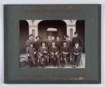
Photograph - Councillor group portrait, W H Robinson, Strathfieldsaye Shire Council, 1909
The district of Strathfieldsaye was proclaimed in 1861 and named a Shire on the 17th September in 1866. It remained a shire until amalgamation in 1994 when it became part of the City of Greater Bendigo. The shire was located 8 km to the south- east of Bendigo and covered an area of 601 square kilometres and extended from the Calder Highway to the Coliban and Campaspe Rivers. The shire's administration centre was in Strathfieldsaye until 1972 when new offices were opened in Kennington.Photographic group portrait of eleven Strathfieldsaye Shire Councillors in front of the Strathfieldsaye Shire Hall. Five men are seated and six standing with one man standing further in back ground on the building's verandah. Photograph is attached directly to green mount card and framed. Gold lettering on mount.Strathfieldsaye Shire Councillors / R. B. Brennan (Sec.) W. J. Lowdes S. Doak M. Burns () N Condon B. Code (Inspector) / WH Robinson Photo Bendigo / T Somerville / W. I. Long / Fred Osborne (President) H Keck / W Dresler / With the President's (Cr. Fred Osborne) Compliments / September 23rd, 1909shire of strathfieldsaye, strathfieldsaye shire council, president of strathfieldsaye shire, strathfieldsaye shire hall -
 City of Greater Bendigo - Civic Collection
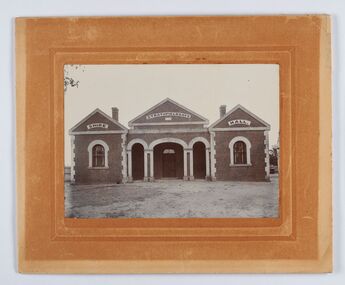
Photograph - Strathfieldsaye Shire Hall
The district of Strathfieldsaye was proclaimed in 1861 and named a Shire on the 17th September in 1866. It remained a shire until amalgamation in 1994 when it became part of the City of Greater Bendigo. The shire was located 8 km to the south- east of Bendigo and covered an area of 601 square kilometres and extended from the Calder Highway to the Coliban and Campaspe Rivers. The shire's administration activities were centred at the Strathfieldsaye Shire Hall which was built in 1869 at a cost of £700 based on a design by George Steane, the shire surveyor and built by George Pallett of Sandhurst. Constructed of red brick, the hall has a unique ventilation system with hollow walls open at the top and bottom to ensure a draught to cool the building in summer. Framed and mounted photograph of the Strathfieldsaye Shire Hall. Verso; W M Robinson / Photographer / Mundy Street Bendigostrathfieldsaye shire hall, shire of strathfieldsaye, strathfieldsaye shire council