Showing 2473 items
matching district views
-
 Eltham District Historical Society Inc
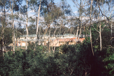
Slide - Photograph, Development either side of Railway Road viewed from across Railway Parade, Eltham, c.Nov. 2001
Part of a slide show presentation "A Trip Down the Diamond Creek" by Russell Yeoman to the Eltham District Historical Society meeting of 14 Nov. 200135mm colour positive transparency Mount - Black and Whiteeltham north, housing estate, railway parade, railway road, eltham -
 Eltham District Historical Society Inc
Slide - Photograph, Northeast view from near 68 Porter Street, Eltham, c.Nov. 2001
Part of a slide show presentation "A Trip Down the Diamond Creek" by Russell Yeoman to the Eltham District Historical Society meeting of 14 Nov. 200135mm colour positive transparency Mount - Black and Whiteeltham, porter street -
 Eltham District Historical Society Inc
Slide - Photograph, Southeast view from near 60 Porter Street, Eltham, c.Nov. 2001
Part of a slide show presentation "A Trip Down the Diamond Creek" by Russell Yeoman to the Eltham District Historical Society meeting of 14 Nov. 200135mm colour positive transparency Mount - Black and Whiteeltham, porter street -
 Eltham District Historical Society Inc
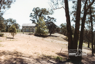
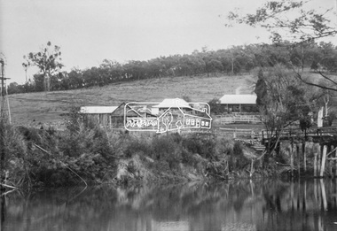
Photograph, The Jelbart Barn, 93 Arthur Street, Eltham, 1972c
Owned at the time by architect, Ian Jelbart, the property had been in the Jelbart family since the 1940s; a 5560sqm secluded hilltop parcel in Eltham. When the manor house and its barn were built, Eltham was a rural community; Jelbart’s grandfather Ronald was a businessman whose poultry farm formed part of the family’s original 100ha holding. A portion would later be subdivided into residential lots to make way for new homes that would form the basis of the Woodridge Estate in the early 1970s. This is a view of the Barn from the main manor house.Digital file only; created from scan undertaken by EDHSarthur street, eltham, houses, jelbart barn, jelbart property, kinloch gardens -
 Eltham District Historical Society Inc
Document, Prospectus: Kinloch Gardens, Eltham Victoria, 1998c
“Kinloch Gardens at Eltham, Victoria is planned as a comprehensively designed and cohesive residential environment.” “Only twelve innovatively designed houses ,will be situated within the established gardens and grounds of this historic Eltham estate. Building design and development will be under the control of the Kinloch Gardens design and construction team.” “Kinloch Gardens is situated on one of the highest points in Eltham and enjoys panoramic views in all directions.” “Kinloch Gardens lies hidden from the outside world behind high stone retaining walls, terraced embankments and extensive landscaping. The existing buildings, amongst the most significant of the Eltham / Montsalvat domestic building tradition are set in park like surrounds and enjoy panoramic views of the ranges to the north east and the city sky line to the west. New houses combined with sensitive landscaping will blend immediately into the established garden environment and will share the amenity and ambience of a very private and unique estate. The central theme of the landscape master plan is a garden reserve and a planted avenue terminating in a -small square.” “Houses vary in size from 120m2 (12.9 squares) to 210m2 (22.6 squares) (or larger) and include an extensive range of planning options. House types include: The Studio House The Tower House The Pergola House The Gallery House 'The Barn' is one of the existing buildings of Kinloch Gardens and is situated on the premium Lot 11.” Developer: Kinloch Pty Ltd. Project Managers: Creative Block Design Pty Ltd. Architects: Graeme Gunn and Ian Jelbart. Landscape Architect: Suzy Boyd. Builder: Vizarje Homes Pty Ltd. Surveyors and Engineers: Miller Merrigan.Digital file only; created from scan undertaken by EDHSarthur street, creative block design pty ltd., eltham, graeme gunn, houses, ian jelbart, kinloch gardens, kinloch pty ltd, miller merrigan, real estate, suzy boyd, vizarje homes pty ltd. -
 Eltham District Historical Society Inc
Document, Kinloch Gardens Property Album; Elders Real Estate sales material, 1998
“Kinloch Gardens at Eltham, Victoria is planned as a comprehensively designed and cohesive residential environment.” “Only twelve innovatively designed houses ,will be situated within the established gardens and grounds of this historic Eltham estate. Building design and development will be under the control of the Kinloch Gardens design and construction team.” “Kinloch Gardens is situated on one of the highest points in Eltham and enjoys panoramic views in all directions.” “Kinloch Gardens lies hidden from the outside world behind high stone retaining walls, terraced embankments and extensive landscaping. The existing buildings, amongst the most significant of the Eltham / Montsalvat domestic building tradition are set in park like surrounds and enjoy panoramic views of the ranges to the north east and the city sky line to the west. New houses combined with sensitive landscaping will blend immediately into the established garden environment and will share the amenity and ambience of a very private and unique estate. The central theme of the landscape master plan is a garden reserve and a planted avenue terminating in a -small square.” “Houses vary in size from 120m2 (12.9 squares) to 210m2 (22.6 squares) (or larger) and include an extensive range of planning options. House types include: The Studio House The Tower House The Pergola House The Gallery House 'The Barn' is one of the existing buildings of Kinloch Gardens and is situated on the premium Lot 11.” Developer: Kinloch Pty Ltd. Project Managers: Creative Block Design Pty Ltd. Architects: Graeme Gunn and Ian Jelbart. Landscape Architect: Suzy Boyd. Builder: Vizarje Homes Pty Ltd. Surveyors and Engineers: Miller Merrigan.Digital file only; created from scan undertaken by EDHSarthur street, elders real estate, eltham, kinloch gardens, real estate agent, the barn -
 Eltham District Historical Society Inc
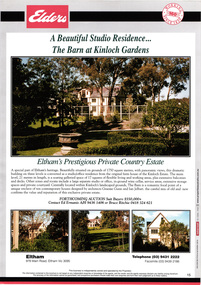
Document - Brochure, The Barn at Kinloch Gardens; Elders Real Estate sales material, 1998
Description by Elders Real Estate: A Beautiful Studio Residence: The Barn at Kinloch Gardens Eltham's prestigious Private Country Estate A special part of Eltham's heritage. Beautifully situated on grounds of 1750 square metres with panoramic views, this dramatic building on three levels is converted to a ? office residence from the original farm house of the Kinloch Estate. The main level, 21 metres in length, is a soaring galleried space of 17 squares of flexible living and working areas, extensive storage spaces and private courtyard. Centrally located within Kinloch's landscaped grounds. The Barn is a romantic focal point of a unique enclave of ten contemporary house designed by Graeme Gunn and Ian Jelbart, the cultural mix of old and new confirms the value and reputation of this exclusive private estate. Digital file only; created from scan undertaken by EDHS of item on loanarthur street, elders real estate, eltham, houses, jelbart property, kinloch gardens, real estate agent, the barn, woodridge estate -
 Eltham District Historical Society Inc
Work on paper (Sub-Item) - Photograph, The Kinglake escarpment. View from Bald Spur lookout across Arthurs Creek to Mount Sugarloaf, 1980
kinglake, blad spur, arthurs creek, mount sugarloaf -
 Eltham District Historical Society Inc
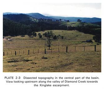
Work on paper (Sub-Item) - Photograph, Dissected topography in the central part of the Diamond Creek basin. View looking upstream along the valley of Diamond Creek towards the Kinglake escarpment
kinglake, escarpment -
 Eltham District Historical Society Inc
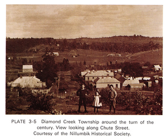
Work on paper (Sub-Item) - Photograph, View along Chute Street, Diamond Creek township, about 1901
diamond creek, chute street, view, nillumbik historical society -
 Eltham District Historical Society Inc
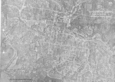
Work on paper (Sub-Item) - Aerial Photograph, Diamond Creek from Yarra River to Wattletree Road, Eltham
Black and white aerial photograph witrh key features around the central place of Eltham township marked inluding Yarra River, Main Road, Bridge Street and Ryans Road, Eltham North land development, real estate, aerial view, eltham, eltham north -
 Eltham District Historical Society Inc
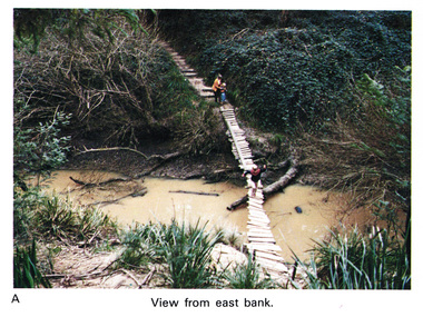
Work on paper (Sub-Item) - Photograph, Home-made footbridge across Diamond Creek, opposite Gum Glade, Eltham
Colour photograph of home-made footbridge across the Diamond Creek opposite Gum Glade, Eltham. View from east bank.eltham, diamond creek, footbridge, gum glade -
 Eltham District Historical Society Inc
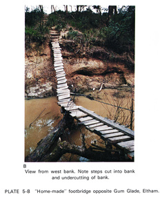
Work on paper (Sub-Item) - Photograph, Home-made footbridge across Diamond Creek, opposite Gum Glade, Eltham
Colour photograph of home-made footbridge across the Diamond Creek opposite Gum Glade, Eltham. View from west bank. Note steps cut into bank and undercutting of bankeltham, diamond creek, footbridge, gum glade, creek bank -
 Eltham District Historical Society Inc
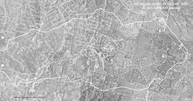
Work on paper (Sub-Item) - Photograph, St Helena East, St Helena West and Eltham West drains, ca 1980
black and white aerial photograph with boundary and drains marked over three page fold out eltham, st helena, drains, aerial view -
 Eltham District Historical Society Inc
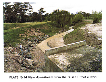
Work on paper (Sub-Item) - Photograph, View downstream from the Susan Street culvert
Colour photograph of the view downstream from the Susan Street culvert, Elthameltham, susan street, culvert, drain, channel -
 Eltham District Historical Society Inc
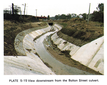
Work on paper (Sub-Item) - Photograph, View downstream from the Bolton Street culvert
Colour photograph of the view downstream from the Bolton Street culvert, Elthameltham, channel, concrete, drain, bolton street -
 Eltham District Historical Society Inc
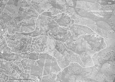
Work on paper (Sub-Item) - Photograph, Research Creek
Black and White aerial photograph of Research witht the Research Creek and Main Road highlighted.eltham, research, aerial view, research creek -
 Eltham District Historical Society Inc
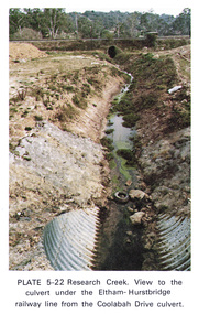
Work on paper (Sub-Item) - Photograph, Research Creek. View to the culvert under the Eltham-Hurstbridge railway line from the Coolabah Drive culvert
Colour photograph of Research Creek. View to the culvert under the Eltham-Hurstbridge railway line from the Coolabah Drive culvert, Elthameltham, research creek, coolabah drive, culvert, eltham hurstbridge railway, drain -
 Eltham District Historical Society Inc
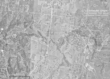
Work on paper (Sub-Item) - Photograph, Diamond Creek from Wattletree Road, Eltham to Diamond Creek township
Black and white aerial view of Diamond Creek from Wattletree Road, Eltham to Diamond Creek Townshipeltham, drain, diamond creek -
 Eltham District Historical Society Inc
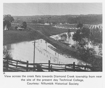
Work on paper (Sub-Item) - Photograph, View across the creek flats towards Diamond Creek township
Undated black and white photograph of view across the creek flats towards Diamond Creek township showing the railway line, with the Diamond Creek under flood. Situated behind the vicinity of Diamond Valley College, Main Hurstbridge Road, Diamond Creek. Diamond Valley College was formed in 1989 from the almagamation of Diamond Creek Technical School and Hurstbridge High School. Nillumbik Historical Society collectionflood, diamond creek, nillumbik historical society -
 Eltham District Historical Society Inc
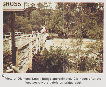
Work on paper (Sub-Item) - Photograph, Flooding, View of Diamond Street Bridge, Eltham 8 April 1977
Colour photograph. Flooding of Diamond Creek at Diamond Street Eltham bridge approximately 2 1/2 hours after the flood peak. Note debris on the bridge deck. 8 April 1977. flood, diamond creek, flooding, eltham, diamond street, bridge -
 Eltham District Historical Society Inc
Photograph, Steam locomotive K-158 crossing the railway bridge over the Campaspe River at Rochester, Victoria, c.November 1963, 1963
It is the railway bridge over the Campaspe River at Rochester, Vic. original to the construction of the line. It was taken late on a Saturday morning and shows the regular goods train of that period approaching, then crossing the bridge. I originally planned to take just one view. The approaching train was first then it was a rapid run back along the raised river bank to get the broadside shot. I had little time to steady myself or properly check camera settings, hence the slightly soft focus etc. The train would eventually continue over the Echuca Iron Bridge into NSW. I think its ultimate destination was Deniliquin but not sure.Digital TIFF file Scan of 35mm Ilford FP3 black and white negative transparencygeorge coop collection, k-158, k-class steam locomotive (vr newport workshops), railway bridge, campaspe river, rochester -
 Eltham District Historical Society Inc
Photograph, Steam locomotive J-500 and goods train crossing the Echuca-Moama Road Rail Bridge, November 1963, 1963
View at guard’s van end of steam train moving over the Echuca Iron Bridge looking north into Moama, New South Wales.Digital TIFF file Scan of 35mm Ilford FP3 black and white negative transparencyechuca-moama road rail bridge, george coop collection, goods train, j-500, j-class steam locomotive (vulcan foundry) -
 Eltham District Historical Society Inc
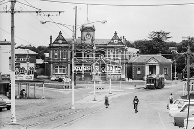
Photograph, Bendigo Tramways No. 2 en route to Quarry Hill outside Eaglehawk Town Hall, January 1972, Jan 1972
Viewed from High Street (Loddon Valley Highway) looking northwest from near Napier StreetDigital TIFF file Scan of 35mm Ilford FP3 black and white negative transparencybendigo, bendigo tramways no. 2, eaglehawk, eaglehawk mechanics institute, eaglehawk town hall, george coop collection, high street, loddon valley highway, milk bar, quarry hill, sailors gully road, tram -
 Eltham District Historical Society Inc
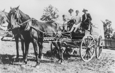
Photograph, View of two men wearing hats with a young woman seated in between on a cart harnessed to two horses, possibly Diamond Creek and Hurstbridge district, c.1920
Black and white copy of photo printed on glossy photographic paper 30.5 x 40.5 cm (12 x 16 inch); image size approx. 18.5 x 28 cmdiamond creek, groups, horse, horse drawn carriage, hurstbridge -
 Eltham District Historical Society Inc
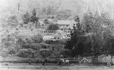
Photograph, Elevated view of farmhouse and buildings, possibly Diamond Creek and Hurstbridge district, c.1900
Black and white copy of photo printed on glossy photographic paper 30.5 x 40.5 cm (12 x 16 inch); image size approx. 18.5 x 28 cmdiamond creek, farm-buildings, fences, horse, hurstbridge -
 Eltham District Historical Society Inc
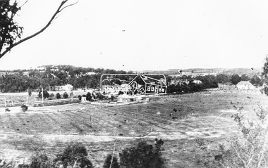
Photograph, Elevated view, most likely of Hursbridge, c.1910
Black and white copy of photo printed on glossy photographic paper 30.5 x 40.5 cm (12 x 16 inch); image size approx. 18.5 x 28 cmhurstbridge -
 Eltham District Historical Society Inc
Photograph, Henley Bridge, c.1928
Situated on the Yarra River, 5.5 kms south of Christmas Hills on private property. This timber trestle bridge is said to have been built some time after 1907 by Melbourne master-builder, David Mitchell (the father of Dame Nellie Melba), to connect his two "Henley Farm" properties with Lilydale. In earlier days, when the McPhersons owned the property, their children used a punt to cross the river to attend Yering Primary School. This private bridge is best viewed from the end of Wendy Way. - Source: Christmas Hills Past and Present, Yarra Glen & District Historical Society, 2004.This photo forms part of a collection of photographs gathered by the Shire of Eltham for their centenary project book,"Pioneers and Painters: 100 years of the Shire of Eltham" by Alan Marshall (1971). The collection of over 500 images is held in partnership between Eltham District Historical Society and Yarra Plenty Regional Library (Eltham Library) and is now formally known as the 'The Shire of Eltham Pioneers Photograph Collection.' It is significant in being the first community sourced collection representing the places and people of the Shire's first one hundred years.9 x 12.5 cm printshire of eltham pioneers photograph collection, warrandyte, henley bridge -
 Eltham District Historical Society Inc
Photograph, Batter treatment, McFarlane Street, Montmorency, 1 July 1972, 1972
View looking at numbers 6 and 8 McFarlane Street35mm colour positive transparency blue Agfacolour Service plastic mounthouses, infrastructure, mcfarlane street, montmorency, streets -
 Eltham District Historical Society Inc
Photograph, Baldwin Avenue from Mountain View Road, Montmorency, c.1972, 1972c
Shire of Eltham road construction and realignment works on Baldwin Avenue, Lilicur Road and Price Avenue, Montmorency, c.197235mm colour positive transparency blue Agfacolour Service plastic mountbaldwin avenue, infrastructure, mountain view road, road construction