Showing 1947 items matching "floods"
-
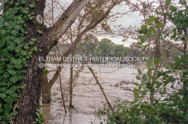
 Eltham District Historical Society Inc
Photograph, Diamond Creek floodwaters, Brougham St Bridge submerged, Eltham, February 2005
... floods ...Roll of 35mm colour negative film, 7 stripsKodak GC400-8diamond creek, eltham, floods -
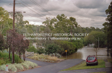
 Eltham District Historical Society Inc
Photograph, Diamond Creek floodwaters, looking towards Susan St, Eltham, Jan-Feb 2005, February 2005
... floods ...Roll of 35mm colour negative film, 7 stripsKodak GC400-8diamond creek, eltham, floods -
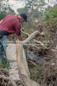 Eltham District Historical Society Inc
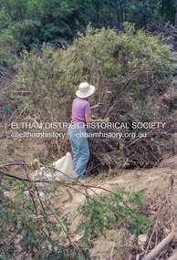
Negative - Photograph, Cleaning up debris following flooding of the Diamond Creek in Eltham, Nov-Dec 2004, February 2005
... floods ...Roll of 35mm colour negative film, 7 stripsKodak GC400-8diamond creek, eltham, floods -
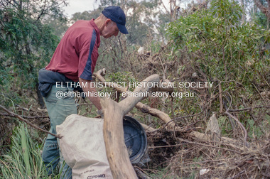 Eltham District Historical Society Inc
Photograph, Cleaning up debris following flooding of the Diamond Creek in Eltham, Nov-Dec 2004, 2004
... floods ...Roll of 35mm colour negative film, 7 stripsKodak GC400-8diamond creek, eltham, floods -
 Eltham District Historical Society Inc
Photograph, Cleaning up debris following flooding of the Diamond Creek in Eltham, Nov-Dec 2004, Frebruary 2005
... floods ...Roll of 35mm colour negative film, 7 stripsKodak GC400-8diamond creek, eltham, floods -
 Eltham District Historical Society Inc
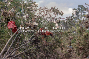
Negative - Photograph, Debris following flooding of the Diamond Creek in Eltham, Nov-Dec 2004, February 2005
... floods ...Roll of 35mm colour negative film, 7 stripsKodak GC400-8diamond creek, eltham, floods -
 Eltham District Historical Society Inc
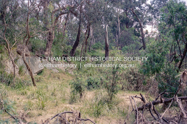
Photograph, Aftermath of flooding of the Diamond Creek in Eltham, Nov-Dec 2004, 2004
... floods ...Roll of 35mm colour negative film, 7 stripsKodak GC400-8diamond creek, eltham, floods -
 Eltham District Historical Society Inc
Negative - Photograph, Diamond Creek floodwaters, Eltham, February 2005
... floods ...Roll of 35mm colour negative film, 7 stripsKodak GC400-8diamond creek, eltham, floods -
 Eltham District Historical Society Inc
Photograph, Peter Pidgeon, Flooded foot bridge across Diamond Creek, Wingrove Park Trail, 2004
... floods ...Digital file onlyfloods, diamond creek, wingrove park trail -
 Eltham District Historical Society Inc
Photograph, Marjorie North, Brougham Street, Eltham looking east, 1985-1986, 1986
... floods ...Negatives supplied by Marjorie North 1 July 1986 for Montmorency France albumRoll of 35mm colour negative film, 4 of 6 stripsKodak CP 100 5094brougham street, eltham, floods -
 Merbein District Historical Society
Photograph, Murray River flood Abbotsford, 1956
... Floods ...abbotsford bridge, murray river, floods -
 Merbein District Historical Society
Photograph, Murray River flood Abbotsford Bridge, 1956
... Floods ...abbotsford bridge, murray river, floods -
 Clunes Museum
Flyer, Victorian Government, FLOOD RECOVERY COMMUNITIES AND THE ENVIRONMENT, C 2012
FLOOD RECOVERY COMMUNITIES AND ENVIRONMENTA4 DOUBLE SIDED FLYER FROM NORTH CENTRAL CATCHMENT MANAGEMENT AUTHORITY (NCCMA). COLOUR PHOTOS AND TEXT ON FRONT AND MAP OF AFFECTED AREAS ON THE BACK.nccma, flood recovery -
 Charlton Golden Grains Museum Inc
Photograph, c.1973
Wooroonook Flood Waters 1973Black and white photo with a white boarder.flood, charlton, wooroonook, lakes, parks -
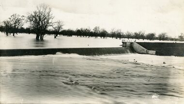 Stawell Historical Society Inc
Photograph, Lake Lonsdale Weir in Flood
Lake Lonsdale Weir in Floodstawell -
 Bendigo Historical Society Inc.
Photograph - BENDIGO ADVERTISER COLLECTION: BIKES, 1993
Photograph: Fitting lights at the Tom Flood Sports Centre Bendigo On Rear: 21/6/93 PH/TC Lights at sports centre, Steve DeAraugo and Shane Rutledge remove the old lights from the tower frames.recreations, sports, cycling, bendigo advertiser -
Port Melbourne Historical & Preservation Society
Photograph - Lasercopy, Crockford Street, Port Melbourne in flood, 1919
Photographs taken around Port Melbourne. Crockford St Port Melbourne in flood March 1919. Shows cable tram moving through water. Floodgate Hotel is at left and Globe hotel is seen above cable trambuilt environment - commercial, transport - tramways, crockford street, cable tram, isobel munday -
Clunes Museum
Document - REPORT
A HAND WRITTEN EXTRACT FROM THE CLUNES GUARDIAN 18TH OCTOBER 1869 REPORTING A FIRE WHICH DESTROYED MANY SHOPS IN FRASER STREET, AND ALSO REPORTING A FLOOD THE FOLLOWING DAY WHICH DAMAGED HOMES AND BUSINESS PREMISES.local history, document, report, clunes history -
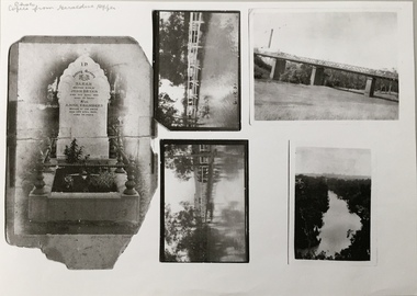 Kew Historical Society Inc
Photograph - Photocopy, Bryan Family Album, Twentieth Century
The Bryan family live din Princess Street, Kew.Photocopies of original photographs relating to or that belonged to the Bryan Family of Princess Street, Kew. The images include the headstone of Sarah Bryan and Anne Chambers; three photos of floods in Kew, one dated 1931; and a view of the River Yarra. bryan family (kew), kew -
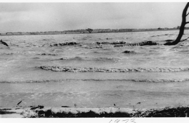
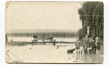 Orbost & District Historical Society
black and white photograph, 1934
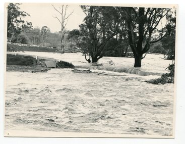
This photograph was taken during the flood of 1934 in Orbost. The people in the photograph are related to Billie and Ilma Nixon and Charlie Johnston. Damage estimated at £500,000 was caused by the 1934 floods in the Orbost district. This 1934 flood was devastating, destroying a section of the 1922 Orbost bridge, wrecking fences, bridges and roads, dumping silt and debris on the rich river flats and drowning cattle.This item is a pictorial record of a significant event in Orbost's history. It is associated with local families.A black / white photograph / postcard of floodwaters. On the right is a young man with four young boys sitting on a log. In the bckground is a rowing boat with one man rowing and three others sitting on the edges . A field of maize / corn is in the background and a large willow tree on the right.on back - "M. C. Rice Orbost 19 /1/20 M Gilbert. Mostly Billy Nixons & Charlie Johnstons 1934" [Note alteration: W C Rice rather than M C Rice].floods-orbost-1934 nixon-william johnston-charles -
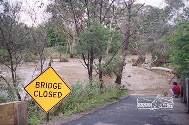
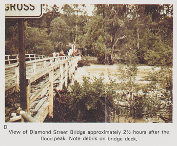 Eltham District Historical Society Inc
Work on paper (Sub-Item) - Photograph, Flooding, View of Diamond Street Bridge, Eltham 8 April 1977
Colour photograph. Flooding of Diamond Creek at Diamond Street Eltham bridge approximately 2 1/2 hours after the flood peak. Note debris on the bridge deck. 8 April 1977. flood, diamond creek, flooding, eltham, diamond street, bridge -
 Eltham District Historical Society Inc
Photograph, Kangaroo Ground-Warrandyte Road, North Warrandyte, c.1988, 1988c
Looking northwest, Floods Road on left.Roll of 35mm colour negative film, 7 stripsFuji 100eltham shire council, infrastructure, kangaroo ground-warrandyte road, north warrandyte, floods road -
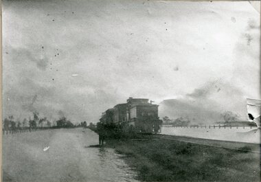 Stawell Historical Society Inc
Photograph, Railway Flood Scene at Lubeck 1909
Railway Flood Scene at Lubeck 1909stawell transport -
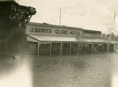 Charlton Golden Grains Museum Inc
Photograph
J Barry's - Globe Hotel - Floodflood, charlton, business, globe hotel -
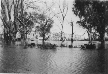
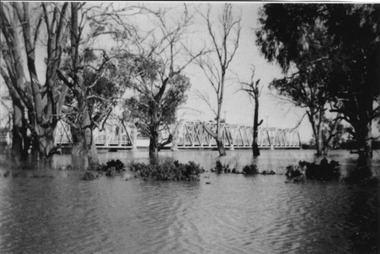
 Orbost & District Historical Society
black and white photograph, February, 1971
This photograph shows the floodwaters during the 1971 flood at Orbost. The two mahogany trees in the photograph stopped the Snowy River from changing its course. The 1971 flood was the the worst flood on record. At Jarrahmond it was at least 11 metres and up to one and a half kilometres wide on the flats causing enormous damage to the flood plain. Records say that "The brown floodwater stain in Bass Strait could be seen from passing airliners." Considerable damage was done to railway infrastructure, roads and farms. More information from the APRIL, 2008 newsletter by John Phillips. (see orbosthistory.com.au)This is a pictorial record of a significant event in the history of floods in Orbost.A black / white photograph of raging floodwaters at the bottom of the Orbost township.orbost-flood-1971 -
 Eltham District Historical Society Inc
Photograph, Looking west from Main Road from just north of intersection with Diamond Street, Eltham, February 1968, Feb 1968
The watercourse passes under the road and railway at this point. Significant flash flooding occurred along this water course on Christmas Day 2011 causing significant damage to the railway line and road and flooding of Judge Book Village. The drain was swept away including the support pillars of the rail lines timber framework. Judge Book Village had some 40 units flooded before the water entered Diamond Creek. The water had flowed down and flooded Valonia Drive then Grove Street before flowing down the watercourse to Main RoadIn February 1968 an unknown person took a series of photos from the Eltham Hotel at Pitt Street heading north along Main Road through the shopping centre to just north of Elsa Court covering the length of the section of Main Road which was duplicated shortly thereafter. Shows the condition and environment of the streesscape of Main Road, Eltham immediately prior to the duplication between Pitt Street and Elsa Court through the shopping centre. Also shows a number of shops and businesses that operated at that time.Black and white photographduplication, eltham, main road, diamond street, watercourse, drainage, railway line -
 Bendigo Historical Society Inc.
Newspaper - JENNY FOLEY COLLECTION: EASTER
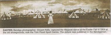
Bendigo Advertiser "The way we were" from Saturday, March 26, 2005. Easter: Bendigo photographer, Vincent Kelly, captured the Maypole dance at the Easter Fair in 1909 at the old showgrounds, now the Tom Flood Sport Centre.newspaper, bendigo advertiser, the way we were -
 Wodonga & District Historical Society Inc
Album - Hume Reservoir Australia Album - Quarry plant being erected September 1921
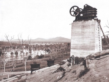
This set of photos is from a leather bound album bearing the inscription "HUME RESERVOIR AUSTRALIA" plus 'The Rt. Hon. L. C. M. S. Amery, P. C., M .P.' all inscribed in gold. It was presented to The Rt. Hon. L. C. M. S. Amery, P. C., M. P, Secretary of State for Dominion Affairs on the occasion of his visit to the Hume Reservoir on 2nd November 1927. This album is of local and national significance as it documents the planning and development of the Hume Reservoir up to 1927. It was the largest water reservoir in the British Empire. The album records the pioneering engineering work that went into its construction.DEPARTMENT OF PUBLIC WORKS, N.S.W. RIVER MURRAY WATERS SCHEME. HUME RESERVOIR. 7. Quarry plant (New South Wales) being erected, September 1921. Murray Flats (in foreground) and Mitta Mitta Flats (beyond) flooded.hume reservoir australia, river murray waters scheme, quarry plant hume -
 Bendigo Historical Society Inc.
Photograph - M. ROSE COLLECTION: BENDIGO CYCLING CLUB
Photograph - black and white. Professional bike riders, 2 men on bikes, 2 men, standing and holding a bike and rider. Looks like taken at the Bendigo showgrounds, now called 'Tom Flood Centre' In background, the covered seating.Percival Pinder, 120 Carpenter Street, Bendigo.organization, club/society, cycling clubs, bendigo cycling club. bendigo showgrounds. tom flood centre. -
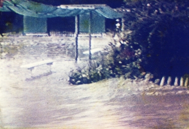 Ringwood and District Historical Society
Photograph, Ringwood Bowling Club- Flooding of greens, 1989
Colour photographPhotograph was taken off the video shots taken by Jack Shandley. The flooding occurred on 10th April, 1989, when four inches of rain fell in 1½ hours.