Showing 553 items matching "hall opening"
-
 Eltham District Historical Society Inc
Photograph, Fitzsimons Lane Bridge over Yarra River between Eltham and Templestowe, c.1966, 1966c
The bridge over the Yarra River was initially opened September 22nd, 1961. Newspaper reports at the time of opening stated it linked Bolton Street, Eltham, with Fitzsimons Lane, Templestowe. In 1955 the Country Roads Board (CRB) produced survey plans that showed proposed land acquisition for the future bridge and road approaches. The 1955 plan shows that it was proposed to connect Fitzsimons Lane with Bolton Street in Eltham by a diagonal road across the river. The road connection would then continue along Bolton Street to Main Road. Prior to construction of the bridge the CRB modified the proposal significantly so that there was a new road parallel with Bolton Street and then curving to join Main Road at what was then its intersection with Old Eltham Road. This involved significantly more land acquisition and altered the pattern of land subdivision through this corridor. Initially the new road was just a single two-way carriageway as it would have required a significant widening of the cutting on the Shire of Eltham side of the river. The road was officially un-named but was known locally as the Eltham-Templestowe Road. The 1966 Melway street directory and other 1960s editions also listed the road as the Eltham-Templestowe Road. In December 1970, Eltham Shire Council, in pursuance of the provisions of the Local Government Act, named it Templestowe Road. The road was renamed Fitzsimons Lane around 1984 in conformity with the section south of the river. In 1991 a new bridge was built to the west of the original bridge. Fitzsimons Lane was widened to four traffic lanes although on the Eltham side this was done within the limits of the existing cutting. NEW BRIDGE STARTS THEM EXPLORING Without any fanfares, Country Roads Board workmen on Friday afternoon put the finishing touches to the approaches, removed the barricades, and let the traffic roll over the new Yarra bridge linking Bolton Street, Eltham, with Fitzsimons Lane, Templestowe. Over the week-end many “bridge watchers” who were making one of their periodic inspections of the progress on the new bridge found to their surprise that they could drive over it, so that people who had gone for a run out to Eltham suddenly found themselves wandering through Templestowe and Doncaster. By Monday the word of the bridge’s opening had got around sufficiently for many regular travellers to the city from Eltham and beyond to vary the monotony by going to town via Templestowe and Kew instead of through Heidelberg. They were surprised at the distances – about 3 ½ miles from Eltham to Templestowe, 6 miles from Eltham Shire hall to the Lower Heidelberg Road-Banksia Street intersection. NEW NEIGHBOURS For people on both sides of the river, the new bridge has turned distant friends into near neighbours. A Greensborough man on Sunday took 35 minutes to reach the home of a friend in East Doncaster, but the return trip over the new bridge took only 17 minutes. It will be some time yet before most people work out the possibilities in shorter and quicker trips form the north-eastern areas to the eastern and south-eastern suburbs. The coming of the warmer months will soon teach many, though the short cuts to Peninsular beaches and eastern suburban drive-ins. And before very long it is likely there will be a Tramways bus running from Templestowe to Eltham station. NEW BRIDGE STARTS THEM EXPLORING (1961, September 27). The Diamond Valley News (News clipping held in SEA_74-1_047) The previously un-named road between Main Road and Yarra River, Eltham South, east of Bolton Street was named Templestowe Road, December 15, 1970 NAMING OF STREETS AND ROADS. (1970, December 15). The Diamond Valley News (News clipping held in SEA_74-2_022)Black and white photographManufacturer's marks: Polaroid, Batch #J62K181 (Sep 1966).infrastructure, shire of eltham infrastructure, bridge, fitzsimons lane bridge, polaroid, yarra river -
 Eltham District Historical Society Inc
Photograph, Fitzsimons Lane Bridge over Yarra River between Eltham and Templestowe
The bridge over the Yarra River was initially opened September 22nd, 1961. Newspaper reports at the time of opening stated it linked Bolton Street, Eltham, with Fitzsimons Lane, Templestowe. In 1955 the Country Roads Board (CRB) produced survey plans that showed proposed land acquisition for the future bridge and road approaches. The 1955 plan shows that it was proposed to connect Fitzsimons Lane with Bolton Street in Eltham by a diagonal road across the river. The road connection would then continue along Bolton Street to Main Road. Prior to construction of the bridge the CRB modified the proposal significantly so that there was a new road parallel with Bolton Street and then curving to join Main Road at what was then its intersection with Old Eltham Road. This involved significantly more land acquisition and altered the pattern of land subdivision through this corridor. Initially the new road was just a single two-way carriageway as it would have required a significant widening of the cutting on the Shire of Eltham side of the river. The road was officially un-named but was known locally as the Eltham-Templestowe Road. The 1966 Melway street directory and other 1960s editions also listed the road as the Eltham-Templestowe Road. In December 1970, Eltham Shire Council, in pursuance of the provisions of the Local Government Act, named it Templestowe Road. The road was renamed Fitzsimons Lane around 1984 in conformity with the section south of the river. In 1991 a new bridge was built to the west of the original bridge. Fitzsimons Lane was widened to four traffic lanes although on the Eltham side this was done within the limits of the existing cutting. NEW BRIDGE STARTS THEM EXPLORING Without any fanfares, Country Roads Board workmen on Friday afternoon put the finishing touches to the approaches, removed the barricades, and let the traffic roll over the new Yarra bridge linking Bolton Street, Eltham, with Fitzsimons Lane, Templestowe. Over the week-end many “bridge watchers” who were making one of their periodic inspections of the progress on the new bridge found to their surprise that they could drive over it, so that people who had gone for a run out to Eltham suddenly found themselves wandering through Templestowe and Doncaster. By Monday the word of the bridge’s opening had got around sufficiently for many regular travellers to the city from Eltham and beyond to vary the monotony by going to town via Templestowe and Kew instead of through Heidelberg. They were surprised at the distances – about 3 ½ miles from Eltham to Templestowe, 6 miles from Eltham Shire hall to the Lower Heidelberg Road-Banksia Street intersection. NEW NEIGHBOURS For people on both sides of the river, the new bridge has turned distant friends into near neighbours. A Greensborough man on Sunday took 35 minutes to reach the home of a friend in East Doncaster, but the return trip over the new bridge took only 17 minutes. It will be some time yet before most people work out the possibilities in shorter and quicker trips form the north-eastern areas to the eastern and south-eastern suburbs. The coming of the warmer months will soon teach many, though the short cuts to Peninsular beaches and eastern suburban drive-ins. And before very long it is likely there will be a Tramways bus running from Templestowe to Eltham station. NEW BRIDGE STARTS THEM EXPLORING (1961, September 27). The Diamond Valley News (News clipping held in SEA_74-1_047) The previously un-named road between Main Road and Yarra River, Eltham South, east of Bolton Street was named Templestowe Road, December 15, 1970 NAMING OF STREETS AND ROADS. (1970, December 15). The Diamond Valley News (News clipping held in SEA_74-2_022)Black and white photographinfrastructure, shire of eltham infrastructure, bridge, fitzsimons lane bridge, yarra river -
 Kew Historical Society Inc
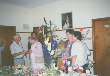
Photograph - Reception by The Mayoress Mrs Ferguson in the Kew City Hall, 1960
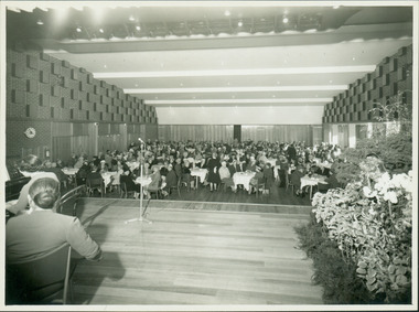
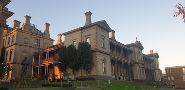
The Kew City Hall, designed by the architect Harold Bartlett of Leith & Bartlett, was opened by The Premier The Hon HE Bolte on 23rd April 1960. At the time of the opening, Cr Ferguson was Mayor of Kew.Original image of the new Town Hall of Kew, providing a detailed view of its interior.Monochrome photograph of the interior of the new Kew City Hall, taken during a Reception given by the Mayoress of Kew in 1960. The orientation of the photograph is directed from the northern (main) stage to the auditorium. The picture reveals the original interior of the Hall before it was converted into a library in 1986-7. Notable is the wooden partition which enabled the Hall to be divided into two halves, as well as the decorative brickwork. The auditorium is arranged with tables and chairs, while on the stage, a pianist is performing in a recital.Cr Ferguson / Mayoress Reception / City Hall 1960kew city hall, harold bartlett, leith & bartlett, city halls -- victoria, cr hugh ferguson -
 Kew Historical Society Inc
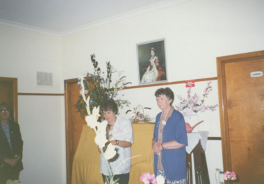
Photograph - Anzac Day Service in front of the Kew City Hall and World War II Memorial, 1960
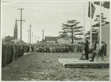
The Kew City Hall, designed by the architect Harold Bartlett of Leith & Bartlett, was opened by The Premier The Hon HE Bolte on 23rd April 1960. At the time of the opening, Cr Ferguson was Mayor of Kew. Monochrome photograph of the annual Anzac Day service on the front lawn of the newly opened Kew City Hall in 1960. The Town Hall faced Cotham Road in front of which are standing returned soldiers. Invited seated and standing guests have their backs to Charles Street and the lawns of South Esk. The speaker would appear to be the Deputy Premier, and local Member for Kew Arthur Rylah MP. Behind the Official Party [but unseen] are the two Memorial plaques by George Henry Allen (1900–72). In the distance are the Kew Presbyterian Church and the Sacred Heart Church. Cr Ferguson / Anzac Day Service 1960kew city hall, city halls -- victoria, cr hugh ferguson, kew town hall, kew (vic.) -- civic buildings, anzac day services -- kew (vic.) -
 Kew Historical Society Inc
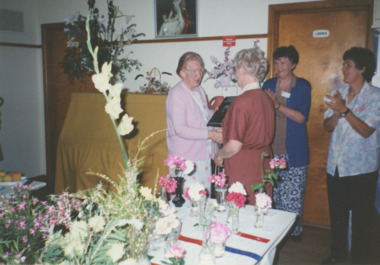
Photograph - Official opening of the Kew City Hall, 1960
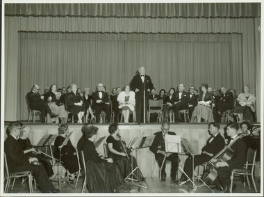
... Cr Ferguson / Official Opening City Hall 1960... Hall 1960 Monochrome photograph of the opening of the new Kew ...The Kew City Hall, designed by the architect Harold Bartlett of Leith & Bartlett, was opened by The Premier The Hon HE Bolte on 23rd April 1960. At the time of the opening, Cr Ferguson was Mayor of Kew.Monochrome photograph of the opening of the new Kew City Hall in 1960. The orientation of the photograph is directed from the main auditorium towards the northern (main) stage. The mayor of Kew at the time was Cr Hugh Ferguson who is addressing the audience from the stage. Behind him are special guests. In front of the main stage are members of the Kew Philharmonic Orchestra. The Premier The Hon HE Bolte is seated in the front row second from the right.Cr Ferguson / Official Opening City Hall 1960kew city hall, harold bartlett, leith & bartlett, city halls -- victoria, cr hugh ferguson, kew town hall, kew (vic.) -- civic buildings -
 Old Colonists' Association of Ballarat Inc.
Photograph, Clare Gervasoni, Opening of the Old Colonists' Club after the 2020 Covid19 Lockdown, 27/11/2020
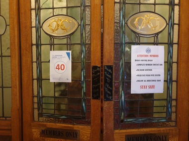
Notices on the leadlight doors of teh Old Colinsts Hall with conditions for entrance after the 2020 Covid19 Lockdown/ballarat old colonists' club, ballarat old colonists' hall, leadlight, covid19, pandemic -
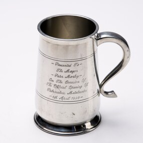 City of Greater Bendigo - Civic Collection
Decorative object - Corporate Gift :: Pewter Tankard, Selmark, 1990
Peter Morley was elected to Council in 1987 and served as Mayor from 1989 - 1990. He was a supporter of restoration of the Town Hall and its use for council meetings as well as the Capital Theatre Project. In the years prior to adequate compensation for Mayors who have a hectic schedule Peter Morley who was in his early 30's when serving as Mayor noted that his own finances where impacted due to taking time off from work (as a plumber) and making financial contributions to attend events. Engraved pewter tankard with handle.Engraved on side; Presented to / The Mayor / Peter Morley / On the Occasion Of / The Official Opening Of / Tubemakers Metalcentre / 6th April 1990 On base; Selmark Pewtermayor morley, city of greater bendigo commerce -
 Linton and District Historical Society Inc
Photograph, Hornby Studio Ballarat, Crowd outside new Shire of Grenville building for opening of new Shire Offices in 1939
Black and white photograph of a crowd of men, women and children posed outside a brick building."New Shire hall".buildings, grenville shire council, shire offices linton, events -
 Box Hill Historical Society
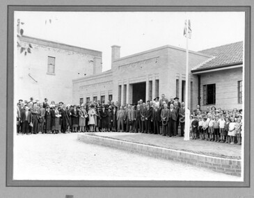
Photograph - Group including Governor of Victoria, Lord Huntingfield at opening of Box Hill Town Hall, 15/04/1935
... Group taken at the opening of the Town Hall, including... April, 1935 at the opening of the Town Hall by the Governor...Group taken at the opening of the Town Hall, including ...Group taken at the opening of the Town Hall, including the Governor of Victoria, his Excellency Lord Huntingfield K.C.M.G., the Mayor (Cr. Boyland), Mayoress and the Town ClerkBlack and white photographTyped notes on back of photo: "Photograph taken on 15th April, 1935 at the opening of the Town Hall by the Governor of Victoria, His Excellency Lord Huntingfield, K.C.M.G./Left to right:/The Mayor (Cr. W. J. Boyland), Lord Huntingfield, Lady Huntingfield, the Mayoress (Mrs. Boyland), the Town Clerk (Mr. H.J. Cole)."opening ceremonies, town halls, box hill town hall, governors, mayors, mayoresses, town clerks, boyland> w.j. (cr.), boyland> - (mrs.), cole> h.j.r. -
City of Moorabbin Historical Society (Operating the Box Cottage Museum)
Newsletter - CMHS Moorabbin Mirror Vol 8 November 2016, Moorabbin Mirror Vol 8 November 2016, 2016
This is Vol. 8 of the Moorabbin Mirror produced by CMHS members Fran & Holger Bader , Valma Sharp November 2016 The Moorabbin Mirror reflects the history and heritage of the former City of Moorabbin — derived from Mooroobin, ‘a resting place’ in the Bunurrung spoken language. In 1994, the City of Moorabbin was integrated into the Cities of Bayside, Glen Eira, Kingston and Monash. Dr.Rosalie Triolo will give a talk for members on Nov. 27th about Local School Teachers in the 1st AIF CMHS AGM Oct 30th. Mrs Valma Sharp retired from Committee and CMHS The Committee proposed a vote of thanks in appreciation of Valma's long , loyal service to CMHS,Box Cottage Museum . Subscriptions for NEW members will be $15 from January 2017. Next AGM will be July 30th 2017 to coincide with the end of the financial year. Due to the cost of ink and postage the CMHS Newsletter Moorabbin Mirror will be available in pdf via email, CMHS website and Victorian Collections website . Local Libraries can assist members to read and or download a copy. GECC and KCC are respectively supporting CMHS/BCM with Community Grants 2016 for utilities and the purchase of laptop, scanner printer copier for the CMHS Original Newsletter Preservation project. The BCM / CMHS joined Glen Eira HS and Brighton Cemetorians for a Heritage Display at GECC Town Hall Gallery Annexe Nov 3rd - 20th. An article about Robert Haddon 1866-1929, architect. Article about Local Artists includes colour photos. The Adelphi Players 'Robinson Crusoe' Dec 3-11 2016, The BCM 'August Rietman Exhibition 2017' is proceeding with guidance from the MAV Roving Curator. Fran Bader, Project Manager, is seeking images, pressed concrete products,information,and recollections. Also any jewellery by Stefanie Rennick (nee Rietman) who was a teacher at Bentleigh Secondary College. CMHS members attended the Opening of the new Bentleigh Railway Station Nov 12th. CMHS now has a mobile phone for incoming enquiries.This is Vol. 8 of the Moorabbin Mirror, Newsletter of CMHS November 2016A4 x 4 paper folded to A5 x 8pp with colour photographsMoorabbin / Mirror / November 2016 Vol 8 moorabbin mirror, bader fran, bader holger, sharp valma, haddon robert, bent tommy, robertson macpherson, reitman august,, brighton cemetery,, glen eira historical society, glen eira city council, -
Surrey Hills Historical Society Collection
Work on paper - Vertical file of information related to music & theatre in Surrey Hills
A vertical file containing the following: 1. Report from BHR, 10/6/1898 – 1 paqe – ‘Concert at Surrey Hills’ mentions Theo Hansen, Emily Walker, Rosalie Hansen and Mr Lumsden. 2. Compilation of various notes by Jocelyn Hall; includes mention of Henry Garrett, brass band concerts, William McRaild, Victorian Scottish Pipe Band, Harald & Stan Sydsereff, Percy Pledger, Win Jacobs, Ernest W Swan and Surrey Hills Musical Club – 1 page, undated. 3. Box Hill and Surrey Hills College of Music – “A concert” – 1 page, 4/12/1911 – photocopy of program; lists staff of the College and Mr Smith, newsagent 4. Notes compiled by Jocelyn Hall re Mrs Constance Clucas and the Operatic Society of Surrey Hills – 1 page; undated. 5. Memories of Jack Colquhuon, July 1988, 2 pages compiled by Jocelyn Hall. Mentions various residents, the opening of the SH picture theatre in 1939, his role as prompter for the Surrey Hills Operatic Society. 6. Notes re Mont Albert Choral Society, Betty Farley, Rayment Fehmel, Marie Collins and Greg Dempsey. 7. Notes from Victoria & its Metropolis re Coy and Zeplin families. 8. Notes re Miss Beryl Tolstrup compiled by Jocelyn Hall. 9. Notes re Ida Holmes (nee Hansen) & Gwendoline Evans compiled by Jocelyn Hall. 10. Notes re Joy Blair Dicker compiled by Jocelyn Hall. 11. Notes re Iris Roderick provided by Mrs Ruth Edgar, 9/11/1988. 12. Notes re the Pay family of Shepherd Street and their link to the Mitchell family. Notes compiled by Jocelyn Hall from information from Lyn Mitchell. NOTE: This contains mis-information regarding the announcement of Australian involvement in WW2. 13. Notes compiled by Jocelyn Hall re the Benwerrin Players from information provided by Jack Colquhuon. 14. Notes compiled by Jocelyn Hall re the Surrey Hills Operatic society provided by Miss Dorothy Clucas, October 1979. -
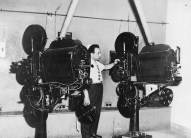 Ithacan Historical Society
Photograph, Film screening at Nicholas Hall, c1950s - 1960s
Stathy Raftopoulos was instrumental in bring Greek films to Melbourne and screened them in various picture theatres in the inner Melbourne suburbs where most post WW2 migrants were living. Prior to the opening of Greek cinemas various venues were used for screenings including Nicholas Hall in Lonsdale Street, Melbourne.With the advent of television many suburban cinemas were no longer drawing the crowds. It was at this time that Stathi Raftopoulos with his partners in the Cosmopolitan Motion Pictures company purchased cinemas in the in suburbs of Melbourne where Greek immigrants were living - in 1960 the National Theatre in Richmond; 1961 the Sun Theatre Yarraville; 1965, the Paramount Theatre Oakleigh, Kinema Theatre Albert Park, and the Empire Theatre Brunswick and Westgarth Theatre Northcote. Here they screened Greek movies which entertained the Greek community supporting them to maintain their link with Greece and their culture and traditions. A black and white photograph of a man standing between two film projectors in a room. -
 Bendigo Historical Society Inc.
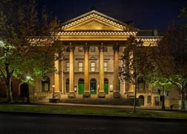
Document - NATIONAL TRUST COLLECTION: CAPITAL THEATRE, 1890-1989
... and 22/10/1874 re opening of the Masonic Hall.../1873 and 22/10/1874 re opening of the Masonic Hall Document ...Capital Theatre Typed article from the Bendigo Advertiser 2/4/1890 re opening of the Masonic Theatre. Six photos, copies from the Australian Sketcher 1873 Article from the Benigo Advertiser 27/1/1978 re demolition. Article from the Bendigo Advertiser Sept 1983 Valuation Letters re original door of Masonic Hall. History of the Masonic Hall by Mr. A Stone. Letter re load of photographs from Doney Photographic Collection Newspaper from Bendigo Advertiser 19/7/1987 and 29/1/1988. Letter and articles concerning the Capital Theatre and council involvement. Typed copy of articles from the Bendigo Advertiser 7/6/1873 and 22/10/1874 re opening of the Masonic Hallbendigo, buildings, capital theatre -
 Lakes Entrance Historical Society
Photograph - Garden club, Bennett Vera, 1994
number in album 03547.03Colour photograph Bruce Hitchins, Joan Cummins, Ian Faulkner, Bob West, Margo Kerby, Pauline Rigby, members of Garden Club at the opening of the 100 Year Festival at the CWA Hall. Lakes Entrance Victoriaclubs, celebrations -
 Lakes Entrance Historical Society
Photograph - Garden club, Bennett Vera, 1994
number in album 03547.02Colour photograph Joan Cummins, Myrtle Hodgson, Margo Kerby, Pauline Rigby, members of Garden Club at the opening of the show for the 100 Year Festival at the CWA Hall. Lakes Entrance Victoriaclubs, function -
 Lakes Entrance Historical Society
Photograph - Garden club, Bennett Vera, 1994
number in album 03547.01Colour photograph Pauline Rigby and Margo Kerby at the opening of the Garden Club show in the CWA Hall during the 100 Years Festival. Lakes Entrance Victoriaclubs, function -
 Ballarat Heritage Services
Photograph - Digital photographs, L.J. Gervasoni, Xavier College Chapel, c2016, c2016
Xavier College was first opened by the Society of Jesus (the Jesuits) in 1878. It belongs to a worldwide network of over 2,000 Jesuit educational institutions. The original Senior Campus location on Barkers Road, Kew is a culmination of modern innovation and rich historical preservation. The land on which Xavier stands was known as Mornane’s Paddock and was purchased by the Jesuits in 1872 from Patrick Mornane on a 20-year interest-free purchase plan. This enabled the Jesuits to get on with the funding and building of the College buildings almost immediately. Foundations for the South Wing commenced in 1872, with the front of the building completed in time for classes to begin in 1878. Many of the first boarders transferred from St Patrick’s College in East Melbourne. With the closure of St Patrick’s years later, many students, associated lay staff and Jesuits also transferred to Xavier College. Over the following century, Xavier College grew with two junior campuses; Burke Hall Campus and Kostka Hall Campus. In recent years, extensive refurbishments, renovations and improvements have moulded the properties into the beautiful sites they are today. In 2002 at our Burke Hall campus and in 2005 at our Kostka Hall campus, the College expanded its educational program, opening Early Years centres to provide the scope for a Jesuit education from the earliest ages. For the first time in the College’s history, girls were admitted to the Early Years, breaking the long-standing tradition of Xavier being a boys-only school. In 2021, after 85 years of inspiring education experiences, our Kostka Hall campus closed its gates for the final time. In 1920, Archbishop Daniel Mannix donated the house and land known as Studley Hall to Xavier College for use as a preparatory school. The property had been purchased and donated to Mannix by Mr T.M. Burke, a Catholic businessman. In 1921, Xavier Preparatory School opened and was later renamed Burke Hall in 1926 in honour of Mr Burke. The Kostka Hall location was opened in 1937 and was named in honour of St Stanislaus Kostka. To establish the second preparatory school, the Jesuits purchased two Brighton properties in mid-1936. Both were promptly remodelled to provide the facilities required for school life. (https://xavier.vic.edu.au/xavier-history, accessed 15/05/2025) Colour photograph of the section of the Chapel at Xavier College, Kew, Victoria. heritage, kew, xavier college, chapel, catholic, st francis xavier, xavier chapel -
 Ballarat Heritage Services
Photograph - Digital photographs, Clare Gervasoni, Melbourne Views from Xavier College Chapel, 2025, 05/2025
Xavier College was first opened by the Society of Jesus (the Jesuits) in 1878. It belongs to a worldwide network of over 2,000 Jesuit educational institutions. The original Senior Campus location on Barkers Road, Kew is a culmination of modern innovation and rich historical preservation. The land on which Xavier stands was known as Mornane’s Paddock and was purchased by the Jesuits in 1872 from Patrick Mornane on a 20-year interest-free purchase plan. This enabled the Jesuits to get on with the funding and building of the College buildings almost immediately. Foundations for the South Wing commenced in 1872, with the front of the building completed in time for classes to begin in 1878. Many of the first boarders transferred from St Patrick’s College in East Melbourne. With the closure of St Patrick’s years later, many students, associated lay staff and Jesuits also transferred to Xavier College. Over the following century, Xavier College grew with two junior campuses; Burke Hall Campus and Kostka Hall Campus. In recent years, extensive refurbishments, renovations and improvements have moulded the properties into the beautiful sites they are today. In 2002 at our Burke Hall campus and in 2005 at our Kostka Hall campus, the College expanded its educational program, opening Early Years centres to provide the scope for a Jesuit education from the earliest ages. For the first time in the College’s history, girls were admitted to the Early Years, breaking the long-standing tradition of Xavier being a boys-only school. In 2021, after 85 years of inspiring education experiences, our Kostka Hall campus closed its gates for the final time. In 1920, Archbishop Daniel Mannix donated the house and land known as Studley Hall to Xavier College for use as a preparatory school. The property had been purchased and donated to Mannix by Mr T.M. Burke, a Catholic businessman. In 1921, Xavier Preparatory School opened and was later renamed Burke Hall in 1926 in honour of Mr Burke. The Kostka Hall location was opened in 1937 and was named in honour of St Stanislaus Kostka. To establish the second preparatory school, the Jesuits purchased two Brighton properties in mid-1936. Both were promptly remodelled to provide the facilities required for school life. (https://xavier.vic.edu.au/xavier-history, accessed 15/05/2025) Colour photograph of the Melbourne highrise from the Chapel at Xavier College, Kew, Victoria. heritage, kew, xavier college, chapel, catholic, st francis xavier, xavier chapel -
 Ballarat Heritage Services
Photograph - Digital photographs, Clare Gervasoni, Exterior Views of Xavier College, 2025, 05/2025
Xavier College was first opened by the Society of Jesus (the Jesuits) in 1878. It belongs to a worldwide network of over 2,000 Jesuit educational institutions. The original Senior Campus location on Barkers Road, Kew is a culmination of modern innovation and rich historical preservation. The land on which Xavier stands was known as Mornane’s Paddock and was purchased by the Jesuits in 1872 from Patrick Mornane on a 20-year interest-free purchase plan. This enabled the Jesuits to get on with the funding and building of the College buildings almost immediately. Foundations for the South Wing commenced in 1872, with the front of the building completed in time for classes to begin in 1878. Many of the first boarders transferred from St Patrick’s College in East Melbourne. With the closure of St Patrick’s years later, many students, associated lay staff and Jesuits also transferred to Xavier College. Over the following century, Xavier College grew with two junior campuses; Burke Hall Campus and Kostka Hall Campus. In recent years, extensive refurbishments, renovations and improvements have moulded the properties into the beautiful sites they are today. In 2002 at our Burke Hall campus and in 2005 at our Kostka Hall campus, the College expanded its educational program, opening Early Years centres to provide the scope for a Jesuit education from the earliest ages. For the first time in the College’s history, girls were admitted to the Early Years, breaking the long-standing tradition of Xavier being a boys-only school. In 2021, after 85 years of inspiring education experiences, our Kostka Hall campus closed its gates for the final time. In 1920, Archbishop Daniel Mannix donated the house and land known as Studley Hall to Xavier College for use as a preparatory school. The property had been purchased and donated to Mannix by Mr T.M. Burke, a Catholic businessman. In 1921, Xavier Preparatory School opened and was later renamed Burke Hall in 1926 in honour of Mr Burke. The Kostka Hall location was opened in 1937 and was named in honour of St Stanislaus Kostka. To establish the second preparatory school, the Jesuits purchased two Brighton properties in mid-1936. Both were promptly remodelled to provide the facilities required for school life. (https://xavier.vic.edu.au/xavier-history, accessed 15/05/2025) Colour photograph of the buildings and Chapel at Xavier College, Kew, Victoria. heritage, kew, xavier college, chapel, catholic, st francis xavier, xavier chapel -
Clunes Museum
Pamphlet, GUARDIAN PRINT
ADVERTISING MATERIAL PRINTED BY GUARDIAN PRINT OF CLUNES .1 FOUR COPIES OF LEAFLET ADVERTISING CONCERT AND DAND AT THE CAMPBELLTOWN HALL THURSDAY FREBRUARY 17TH 1927 .2 SIX COPIES OF A LEAFLET ADVERTISING THE OPENING OF WEEEKLY SALES AT THE CLUNES AUCTION MART BY H A THOMPSON OF DAYLESFORD FIRST SALE TAKES PLACE ON WEDNESDAY 14TH SEPT .3 ONE COPY OF A LEAFLET ADVERTISING CLUNES AUCTION MART BY J A DARLINGTON ALL CLASSES OF GOODS AND PRODUCE RECEIVED FOR AUCTION .4 LEAFLET ADVERTISING METHODIST CHURCH CLUNES IN THE TOWN HALL CLUNES "THE PRINCESS CHRYSANTHEMUM" .5 TEN COPIES OF A LEAFLET ADVERTISING A PUBLIC MEETING TO BE HELD IN THE TOWN HALL CLUNES ON WEDNESDAY FEB 16TH TO CONSIDER THE ESTABLISHMENT OF AN IMPLEMENT WORKS IN CLUNES .6 TWELVE COPIES OF A LEAFLET PRINTED TO ALL MEMBERS AND ADHERENTS OF THE CLUNES METHODIST CHURCH FOR THE ANNIVERSARY SERVICES ON APRIL 19THlocal history, document, pamphlet, churches, wesley -
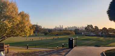
 Bendigo Military Museum
Document - COMMITTEE BDSC 1978, Bendigo District Servicemen's Club, April 1978
This election is possibly the new Committee to manage the Bendigo & District Servicemen's Club in Havilah Road. Cat No 8080 Committee meeting talks about getting ready for the opening of the facility to members. President W.B. Nicholls refer Cat No 8073P. Snr Vice President D.J. Paterson refer Cat No 8073P. Committee member David Patterson refer Cat No 8070.Document, paper all print in black listing the complete Committee of the Bendigo & District Servicemen's Club, has names, position, address and phone number. One name is unreadable due to damage. "Office Bearers of the Bendigo & District Servicemen's Club elected at the meeting held on Thursday 20th April 1978 at Memorial Hall Bendigo".brsl, smirsl, bdsc, committee -
 Bendigo Military Museum
Document - RSL MEETING MINUTES 1978, Bendigo District Servicemen's Club, May 1978
These meeting minutes are possibly one of the first as it discusses the points re Rules, Bar opening, Duties and Responsibilities pre the opening of the Club. Refer Cat No's 8073P and 8079.Document paper, all text in black, one sided re the Minutes of the Bendigo District Servicemen's Club Meeting."Bendigo & District Servicemen's Club meeting 29.5.1978 at Memorial Hall"brsl, smirsl, bdsc, meeting -
 Eltham District Historical Society Inc
Document - Property Binder, 931 Main Road, Eltham
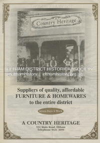
Present day location of Nongkhai Thai Eltham restaurant Formerly the location of: Luther Haleys Bakery and General Store (Sep 1902-1917) - Hayley built this store, which was the first store erected in the present-day Eltham shopping district Hannah Lloyd's General Store (1917-c.Feb 1920) Various owners Staff's General Store (c.1939-Feb 1965) then demolished Ray Staff Eltham Big Star Food Centre (c.1965-1967) Eltham Big Star Food Centre (Staffs new building c.1965-1967) A Country Heritage Furniture and Homewares (?-2006) Newspaper advertisement: Leader Associated Newspapers, 100 Years of News Special Edition, August 27, 1997, p6; A Country Heritage Newspaper advertisement: Diamond Valley Leader, 4 September 2006, Closing Down Sale, A Country Heritage In February 1965, Staffs Railway Store, the oldest business premises in the Eltham shopping district was demolished. Formerly a self-service grocery, restaurant and electrical repair shop, the building for many years housed Eltham’s only ‘family’ grocer and feed store. Earlier it had appeared to have been the town’s bakery. The building had been purchased in late March 1939 by Mr Eric N. Staff. At the time of E.N. Staff’s purchase there were huge bakers’ ovens located at the rear and the building also had a well and four toilets for employees. When the ‘pictures’ came to Eltham with the opening of the Eltham Public Hall across the road in 1941, Mr E.N. Staff extended the business and opened a milk bar and sweet shop. Further extensions re-established the tea rooms of days gone by. Mr E.N. Staff conducted business for about 15 years before handing over the reins to his son, Ray Staff. When his son Ray took over, the milk bar and tea rooms were closed for several years but the milk bar and was later re-opened and subsequently became a greengrocers and later again, a restaurant. The tea rooms section was converted to an electrical repair shop about 1955. Electoral Roll records for 1967 record Raymond Charles Staff at 929 Main Road, Eltham, grocer, and in 1968 at Lot 4, Hillcrest Avenue, Eltham, taxi truck operator. Staff’s store appears to have occupied 929-933 Main Road and the Eltham Big Star Food Centre was centred around 931 Main Road. It would appear that Ray continued to run the business for approximately two years after the original store was demolished and a new supermarket was built. Today, 931 Main Road is the Nongkhai Thai Restaurant and is precisely where the original Staffs store stood. Even though the facade has been modified at eye level with new larger windows, the upper facade is identical to that of the new Eltham Big Star Food Centre of 1965/66. But how did the original building, the oldest premises in the 1965 era shopping centre come about? On August 12th, 1902 at the Eltham Courthouse, appearing before T. Smallman, Esq,. Police Magistrate, and Messrs. W. Duncan and W.J. Taylor, Justices of the Peace is Luther Haley, baker. Wilfred Henry Johnston, by his agent Stanley Ernest Elder had applied for a warrant of ejectment under the Landlord and Tenant Act 1890 against Luther Haley from the bakery premises at the corner of Main Road and York Street. From the evidence presented we learn that Mrs Burgoyne of Eltham had purchased the property some months earlier from Mr Johnston, which consisted of a store and bakery establishment at Eltham occupied by Mr. Luther Haley, and whose lease expired some little time back, and up to the present time, Mr. Haley was not prepared to leave. He informed the court that he is unable to secure at Eltham a suitable house in which to carry on his business, but was building a place near the railway station which he expected to be done in about three weeks time, and he is then prepared to give up possession of the premises he now occupies. Mr Smallman informed the defendant, Luther Haley, that he will have to quit the premises in three weeks from the present date, and that a warrant of ejectment would be issued. However he also informed Mr Haley that he would order the warrant to lie in the office for three weeks from that date. The premises under construction referred to by Luther Haley in court were situated on the western side of Main Road, near the railway station slightly opposite present-day Arthur Street. It was opened around September 1902 as a General Store, Bakery and Tea Rooms. This was the original building in the present-day shopping precinct. At the time the only thing nearby was the railway station. Luther Haley’s business appeared to prosper and he would have catered to not only the locals abut also day visitors by train on Sundays coming up from Melbourne, offering fresh baked produce, tea rooms and summer drinks. The fields across Main Road running between present day Arthur Street and Luck Street were known as Haley’s Paddock and at times were used for community festivities and picnics. A newspaper report on the annual State schools picnic held at Haley’s Paddock on March 11, 1904 described it as “quite close to the railway station, and is quite capable of holding comfortably 10,000 people. With its ample shade and hilly surroundings, it is an ideal place for any gathering.” Luther Haley successfully ran his general store, bakery and tea rooms until 1917 when he and his family departed the district and moved to Westgarth Street in Northcote where he changed careers and became a publisher. It was then taken over by Hannah Lloyd and became known as Lloyd’s Railway General Store from 1917 to 1920. From then it had a succession of owners, one as short as two months until March 31, 1939 when the Grocery Business formerly carried on by Mr. T.K. White of Eltham for the previous eight years was purchased by Mr Eric N. Staff of Research and became known as E.N. Staff’s Railway Store. The ownership timeline for the store is as follows: Luther Haley Sep 1902-1917 Hannah Lloyd 1917-c.Feb 1920 Messrs J.R. & N.E. Lee 1920-Sep 1922 A. & E. Copeland Sep 1922-Sep 1925 Mr Price Sep 1925-Nov 1925 Mr Warren Nov 1925?-Nov 1926 A.W.J. Edwards Nov 1926-1931 T.K. White 1931-Mar 1939 Eric Staff Apr 1939-c.1954 Ray Staff c.1954-Feb 1965 then demolished Ray Staff Eltham Big Star Food Centre c.1965-1967 THROWBACKTHURSDAY: ELTHAM BIG STAR FOOD CENTRE, MAIN ROAD, 1966 https://elthamhistory.wordpress.com/2020/04/16/throwbackthursday-eltham-big-star-food-centre-main-road-1966/eltham, businesses, a country heritage, property, shops, main road eltham, a. copeland, a.w.j. edwards, big star food centre, e. copeland, eric staff, general store, hannah lloyd, j.r. lee, lloyd's general store, luther haley, n.e. lee, price, ray staff, staffs general store, supermarket, t.k. white -
 Ringwood and District Historical Society
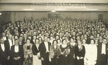
Photograph, A memento of the Charity Ball Ringwood 1.9.1936. Opening night of the New Town Hall
Black and white photograph (2 copies- 1 postcard size, 1 larger copy)Written on back of large photograph: "Opening night of Ringwood Town Hall- Charity Ball, 1936." Cr A.T. Miles front LH side next to Cr A. Blood. H.F. Pearson & Mrs Pearson also in frot Row. -
 Bendigo Historical Society Inc.
Mixed media - GRAYDON COLLECTION: FAMILY PHOTOGRAPHS and NOTES (See ITEM 11411)
Charles Wallace Gordon Graydon the First came out to Victoria on the S.S. Almora, the same ship on which Eliza Richardson and her family arrived on New Years Day 1875. Evidently C.W.G.G.1st. must have retained fond memories of a young fourteen-year-old girl named Elizabeth Richardson who travelled from Scotland with her mother and family (her father had arrived earlier) because three years later at Kyneton they were married. It was December 26th, 1860, and Elizabeth was just seventeen. As the bridegroom’s age is written as 24 years on the wedding certificate, he certainly must have been more than eighteen when he sailed on the "Almora" in 1856. The newly married couple went to live at Taradale, Victoria, and they made a good life for themselves in that town which had then a thriving gold mine. They lived in a large two-storied house in Survey Paddock, and it was there that four daughters - Susan Emily (1861-1906), Elizabeth Constance (1863-1945), Amelia Amy (1865 -1952, Ada Mary Maude (1867-1901), and one son Newenham Edward Eustace (1869-1945) named after his Irish Grandfather, were born. On his wedding certificate C.W.G. Graydon, is described as a foreman. His father-in-law, Robert Richardson was employed as a timekeeper on the Melbourne to Bendigo Railway works, and he and his family lived first in Prahran, then Kyneton, and then Taradale. Perhaps Charles Graydon worked on the railway with him. In Taradale however, he worked for a gold mining company in a surveying capacity. C.W.G.G.1st was to become Shire President of the Shire of Metcalfe. That particular year the Graydon Family entertained the visiting English cricket Eleven at their home in Taradale. He was certainly regarded as an important man in the district when he was requested by a great number of the residents to nominate for the Legislative Assembly election. About 1876 the Graydons left Taradale, and went to live at Sandhurst, now Bendigo, at Barkly Place East. The Richardsons had also left Taradale to go into the grocery business in the same town. Charles Wallace Gordon Graydon the First became a legal manager of mines, and a well-known and popular resident. Sad to say he became ill with a lung infection, and on June 4th. 1885 he died, and was buried at Sandhurst, now Bendigo Cemetery, Back Creek Rd. Eliza Richardson's brother was Mr. James Richardson, the well-known grocer, of Pall Mall and Golden-square, who died at his residence, "Balgownie," Short Street, on Thursday 22 Jan 1914. James Richardson was a native of Scotland. He was born at Glasgow in1849 and was only eight years of age when his parents sailed for Australia in the ship Balmoral. The family arrived in Melbourne in 1857 and went to Taradale, where Mr. Richardson, senior., acted as inspector of works during the construction of the Taradale Viaduct. James Richardson, who had commenced his education in Glasgow, attended school at Taradale until the family removed to Bendigo at the time the railway was being built from Bendigo to Echuca. The contractors for this work engaged Mr. Richardson, as their timekeeper. When he left school James Richardson applied himself to learn the grocery business, and he gained a thorough knowledge of it with different employers at Bendigo, Taradale, and Daylesford. In 1872 he opened a grocery store on his own account in High-Street, Bendigo, but within a few months he had the great misfortune to be burnt out. The fire originated in an adjoining building early one morning and both places were burnt to the ground. In spite of his loss, Mr. Richardson was not discouraged, for he soon made another start. His trade improved and he extended his business, opening the Eclipse Cash Store at Golden Square. A little later another branch was opened at the Oddfellows' Hall, and subsequently this business was transferred to the Eureka Cash Store, in Pall Mall, which was the head depot. In addition to the retail trade, Mr. Richardson had, for many years carried on an extensive wholesale business with the Northern District and had made a specialty of fodder seeds. James was a man of probity and sincerity in business, and as a citizen he was highly esteemed and respected. He was a prominent member of the Bendigo Caledonian Society in the earlier days of his citizenship. He was a staunch member of St Andrew's Presbyterian Church, and was a member of the board of management. In the Easter Fair procession, Mr. Richardson's display was always a prominent and attractive one. Mr. Richardson was a member of the Masonic Order and was a life member of the Bendigo Art Gallery and the old Mechanics Institute. He was married at Daylesford in 1871. Mr James Richardson was interred in the Presbyterian section of the Bendigo Cemetery.DVD A selection of Graydon and Richardson family photographs taken by Bendigo photographers, and family history notesphotograph, person, graydon and richardson families. -
 Flagstaff Hill Maritime Museum and Village
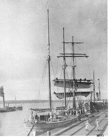
Photograph - Vessels Speculant and S. S. Flinders, Between 1902 and 1907
This photograph was one of ten photographs donated to Flagstaff Hill Maritime Museum and Village by Fred Trewartha. Frederick John Fox Trewartha (Fred) was a well-known Warrnambool businessman. He was born in Beeac near Geelong in 1920 and came to Warrnambool with his family as a very young child. He was apprenticed to his father John, as a saddler and later opened his own shop on Raglan Parade. He then moved into working with tarpaulins and canvases for the trucking industry. Fred was keenly interested in photography (and was a member of the Warrnambool Cine Club), yachting and boat building. He kept his yacht moored at Port Fairy for many years and participated in sailing events locally and interstate. He also built boats with his sons. He had the opportunity to meet many older sailors and it's thought this photo (and others in the set) may have been given to him by one of these men. Fred Trewartha died in 2016 in Warrnambool. The two identifiable ships in this picture are the "Speculant" and the "S. S. Flinders" - both coastal trading vessels that regularly came and went from Warrnambool. The third steamer on the left hasn't been identified The barquentine SPECULANT was a steel, three-masted sailing ship built in 1895 in Inverkeithing, Scotland, registered in Warrnambool, Victoria and wrecked at Cape Paton, Victoria, 10th February 1911. The SPECULANT had been involved in the timber trade between the United Kingdom and Russia, until sold to its Warrnambool owners and timber merchants Messrs. P.J. McGennan & Co. (Peter John McGennan) in 1902 for 3000 pounds and had her sailed to Warrnambool as her new port. Peter John McGennan was born in 1844 and worked as a builder and cooper in Holyhead, Anglesea, Wales. He immigrated to Australia in 1869 as a free settler and arrived in Warrnambool in 1871 and undertook management of a property in Grassmere for Mr. Palmer. Peter met his wife Emily in South Melbourne and they married in 1873. They had ten children including Harry who lived to 1965, and Andrew who lived until 1958. (The other children were their four brothers - John who was killed in the Dardenalles aged 35, Frederick who died aged 8, Peter who died aged 28, Frank who died aged 5 weeks - and four sisters - Beatrice who died age 89, Edith who died aged 49, Blanche who died aged 89 and Eveline who died aged 48.) In 1874 Peter starting a boating establishment on the Hopkins River. In 1875 he opened up a Coopers business in Kepler Street next to what was Bateman, Smith and Co., moving to Liebig Street, next to the Victoria Hotel, in 1877. In 1882 he then moved to Lava Street (which in later years was the site of Chandlers Hardware Store). He was associated with the establishment of the Butter Factory at Allansford. He started making Butter Boxes to his own design and cheese batts for the Butter Factory. In 1896 established a Box Factory in Davis Street Merrivale, employing 24 people at its peak, (it was burnt down in 1923); and in Pertobe Road from 1912 (now the Army Barracks building). Peter was a Borough Councillor for Albert Ward from 1885 to 1891, he commenced the Foreshore Trust (including the camping grounds along Pertobe Road), and he was an inaugural Director of the Woollen Mill in Harris Street, buying an extensive share-holding in 1908 from the share trader Edward Vidler. They lobbied the Town Hall to have a formal ‘Cutting’ for the waters of the Merri River to be redirected from its natural opening south of Dennington, to its existing opening near Viaduct Road, in order to have the scourings from the wool at the Woollen Mill discharged into the sea. He sold Butter Boxes around the state, and had to ship them to Melbourne by rail. Peter’s purchase of the SPECULANT in 1902 enabled him to back-load white pine from Kaipara, New Zealand to Warrnambool to make his butter boxes then, to gain profitability, buy and ship potatoes and other primary produce bound to Melbourne. (McGennan & Co. had also owned the LA BELLA, which had traded in timber as well, until she was tragically wrecked with the loss of seven lives, after missing the entrance channel to Warrnambool harbour in 1905. It appears that the SPECULANT was bought to replace the LA BELLA.) In 1911 the SPECULANT had been attempting to depart Warrnambool for almost the entire month of January to undergo docking and overhaul in Melbourne. A month of east and south-easterly winds had forced her to remain sheltered in Lady Bay, Warrnambool apart from one morning of northerlies, when an attempt was made to round Cape Otway; she had to return to shelter in Portland after failing to make any headway. With only 140 tons of sand ballast aboard, the ship would not have been easy to handle. Captain Jacobsen and his crew of nine, mainly Swedes, decided to make for Melbourne, leaving Portland Harbour on 5th February 1911. By the 9th they had reached Cape Otway, where they encountered a moonless night, constant heavy rain, and a heavy sea with a south-easterly wind blowing. After safely rounding Cape Otway the course was changed to east, then north-east to take the vessel to a point six miles off Cape Patton, following the orders of Captain Jacobsen, who told the crew to be very careful with the steering, as the wind and sea was running to leeward. The patent log (used to measure speed) had been out of order for the last four months as no-one in Warrnambool was able to fix it: it was intended to have it repaired in Melbourne. In the meantime the crew measured the vessel's speed by looking over the side and estimating wind strength. This compounded the difficulties of imprecise positioning, as the strong cross wind and sea were acting on the lightly laden vessel to steadily drive it towards the shore. At 3.30am on Friday 10 February 1911 Captain Jacobsen and the first mate were looking over the side of the vessel when they heard the sound of breakers and suddenly struck the rocks. The crew immediately knew they had no chance of getting the SPECULANT off, and attempted to rescue themselves by launching the lifeboat, which was instantly smashed to pieces. One of the crew then volunteered to take a line ashore, and the rest of the crew were all able to drag themselves to shore, some suffering hand lacerations from the rocks. Once ashore they began to walk along the coast towards Lorne, believing it was the nearest settlement. Realising their mistake as dawn broke they returned westwards to Cape Patton, and found a farm belonging to Mr C. Ramsden, who took them in and gave them a change of clothes and food. After resting for a day and returning to the wreck to salvage some of their personal possessions, at 10am on Saturday they set out for Apollo Bay, a voyage that took six hours, sometimes wading through flooded creeks up to their necks. The Age described the wreck as "listed to starboard. All the cabin is gutted and the ballast gone. There is a big rock right through the bottom of her, and there is not the slightest hope of getting her off". A Board of Marine inquiry found that Captain Jacobson was guilty of careless navigation by not taking steps to accurately verify the position of the vessel with respect to Cape Otway when the light was visible and by not setting a safe and proper course with respect to the wind and sea. It suspended his certificate for 6 months and ordered him to pay costs. The location of the wreck site was marked for a long time by two anchors on the shoreline, until in 1970 the larger of the two anchors was recovered by the Underwater Explorers' Club and mounted on the foreshore at Apollo Bay. The bell from the wreck was also donated to the Apollo Bay Surf Lifesaving Club but is recorded to have been stolen. Rusting remains of the wreck can still be found on the shoreline on the southern side of, and directly below Cape Patton. Parts of the SPECULANT site have been buried by rubble from construction and maintenance works to the Great Ocean Road, as well as by naturally occurring landslides. Peter J McGennan passed away in 1920. The Gates in the western wall of the Anglican Church in Henna Street/Koroit St are dedicated to him for his time of community work, which is matched with other prominent Warrnambool citizens; Fletcher Jones, John Younger, J.D.E (Tag) Walter, and Edward Vidler. After Peter J McGennan's death Harry, Andrew and Edith continued to operate the family business until July 11th 1923 when the company was wound up. (Andrew lived in Ryot Street Warrnambool, near Lava Street.) Harry McGennan (Peter and Emily’s son) owned the Criterion Hotel in Kepler Street Warrnambool (now demolished). His son Sid and wife Dot lived in 28 Howard Street (corner of Nelson Street) and Sid managed the Criterion until it was decided by the family to sell, and for he remained Manager for the new owners until he retired. Harry commenced the Foreshore Trust in Warrnambool around 1950. The McGennan Carpark in Pertobe Road is named after Harry and there are Memorial-Stone Gates in his memory. (The Gates were once the original entrance to the carpark but are now the exit.). The Patent Log (also called a Taffrail log) from the SPECULANT, mentioned above, and a number of photographs, are now part of the Collection at Flagstaff Hill Maritime Village.. The S. S. Flinders was built by A. J. Inglis, Ltd, Pointhouse, Glasgow in 1878 for the "Tasmanian Steam Navigation Company', Hobart which merged with the "Union Steamship Company" of New Zealand and it was later sold to the firm "McIlwraith, McEacham and Company". It was built of iron and was 1000 tons and 227 feet, 1 inch long. It was described as "splendidly fitted up for the carriage of passengers and her cargo space was also very large". In the saloon about 130 passengers could be accommodated while the second class had sufficient room for one hundred passengers. In 1890, the S. S. Flinders would leave Melbourne on Mondays and Thursdays at 5 pm and reach Warrnambool the following morning at 8 am. On the return it would leave Warrnambool on Wednesdays and Saturdays at 5 pm and reach Melbourne the following morning. In 1896, the Weekly Times described the "steamer Flinders (otherwise known as "the Warrnambool mailboat") as "as good a sample of a seagoing steamer as there is trading on the Victorian Coast at the present time". In April 1896 newspaper reports noted the S. S. Flinders took 2915 bags of potatoes from Warrnambool to Melbourne (the largest shipment of that season) as well as 50 tons of tinned rabbits from the Hamilton Preserving Factory. It was also noted that particularly during the Christmas period, there were excessive demands for berths from holiday makers wanting to enjoy a holiday in Warrnambool. In May 1903, the S. S. Flinders narrowly escaped destruction when an explosion and subsequent fire occurred during the passage from Melbourne to Warrnambool. A drum (which apparently contained carbide of calcium) exploded and blew off a hatch cover. As the steamer got to within a mile or two of Warrnambool, smoke was seen coming out of the hold and (unknown to the passengers) flames had taken hold. The crew quickly got to work - closing down all the hatches and pumping water into the hold through a hole in the saloon floor. There were 30 or 40 cases of kerosene on board. The Flinders continued on to Warrnambool and berthed at the Breakwater. The passengers all went ashore - many unaware of the danger they had been in. A telephone message was sent to the local Fire Brigade Station however the fire was extinguished before the firemen and their equipment arrived. After the hold was checked, the Flinders was certified as seaworthy and left for Portland. The Flinders continued to transport Western District produce as well as passengers from Warrnambool to Melbourne until 1906 when (due to a decrease in shipping trade during the Winter and the availability of train services) the Flinders was replaced by the smaller steamer "Dawn" and in 1907 when it was sold to the "Adelaide Steamship Company" for use in the Western Australia coastal trade, it was replaced by the "S. S. Barrabool".This photograph is a significant record of two of the well known coastal traders (the "Speculant" and the "Flinders") that sailed along the south west coast of Victoria for many years - transporting goods and passengers between Melbourne and Warrnambool.Black and white photograph of the Breakwater in Warrnambool with two ships docked and another in the bay. On the front boat (the Speculant), men can be seen at the wheel, on the deck and on the bottom two booms where they appear to be furling the sails. The sails of the top booms are already furled. A small boy can be seen on the deck and a young girl, two women and a dog are on the Breakwater. There is a steam ship (the S. S. Flinders) tied up behind the "Speculant" and an unidentified steam ship (with smoke coming from its smokestack) in the bay. There is a blue and black handwritten label on the back of the photo - naming the ships and the owner of the photo.Speculant and Flinders / Passenger ship in / Lady Bay / name of donor and phone numberflagstaff hill maritime museum and village, warrnambool, great ocean road, shipwreck coast, speculant, barque speculant, flinders, s. s. finders, steamship flinders, coastal trader, passenger ship, goods, steamer, breakwater, lady bay, warrnambool mailboat, p. j. mcgennan, peter john mcgennan, butter boxes, captain jacobsen, cape patton, tasmanian steam navigation company