Showing 845 items
matching land subdivisions
-
 Bendigo Historical Society Inc.
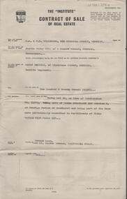
Document - H.A. & S.R. WILKINSON COLLECTION: CONTRACT OF SALE
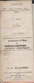
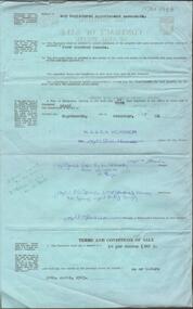
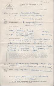
Conditions of sale by private contract dated 21st. October, 1935 between J. Mahon (seller) and H. Taylor (buyer) for land situate Hodgkinson Street, Bendigo having a frontage of approx. 52 feet by a depth of approx. 108 feet, being parts of lots 6 and 7 on plan of subdivision registered No.13862 part of Crown allotments 6 and 7 section 38C land described in Crown grant volume 1502 folio 300225 and Crown grant volume 2642 folio 528242. Price 50 pounds. Attached receipt and plans to build house on that land (W. H. Ellis builder) for 500 pounds also attached detailed list of materials and labour.organization, business, h.a. & s.r wilkinson real estate -
 Bendigo Historical Society Inc.
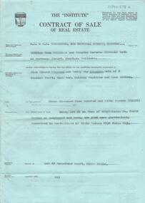
Document - H.A. & S.R. WILKINSON COLLECTION: CONDITION OF SALE
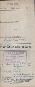
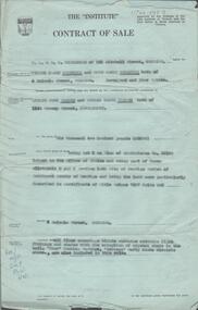
Contract of sale of land dated 23rd June, 1952 between Mr. J.L.C. Hunt (seller) and Miss D.A. Phillips for land being Lot 18 on plan of subdivision No. 14194, being part of Crown allotments 454A and 476 section H described in certificate of title volume 6110, folio 975 situate in Murray Street, Bendigo, together with 50roomed weatherboard dwelling and all sundry. Price 2,525 pounds.organization, business, h.a. & s.r wilkinson real estate -
 Bendigo Historical Society Inc.
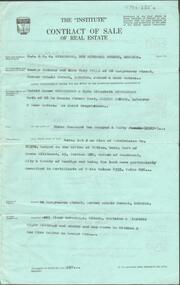
Document - H.A. & S.R. WILKINSON COLLECTION: CONDITION OF SALE
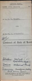
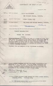
Contract of sale of land dated 29th January 1954 between Mr. E.M. Hopper (seller) and Mr. G.J. O'Donnell (buyer) for land being Lot 2 on plan of subdivision No. 23332 registered in the office of titles, Melbourne and situate in Lindsay Street Kangaroo Flat part of Crown allotment 11 section 23, township of Kangaroo Falt described in Certificate of title volume 7446 folio 423, together with weatherboard dwelling, wood shed-lavatory also fencing on the said land. Price 2,700 pounds.organization, business, h.a. & s.r wilkinson real estate -
 Bendigo Historical Society Inc.
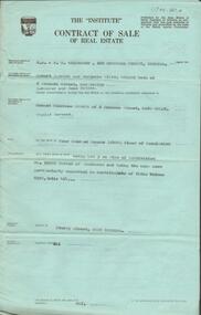
Document - H.A. & S.R. WILKINSON COLLECTION: CONDITION OF SALE
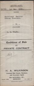
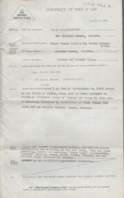
Conditions of sale by private contract dated 1st May, 1942 Fairfield Baptist Church Trustees (William Alfred Newnham, Harry Marsh, Joseph Butters Hughes, James Arthur Dobson as trustees and sellers) and L.L. Rigby (buyer) for land having a frontage of 41 feet to the west of Arthur Street by a depth of 130 feet along the north side of Duncan Street being part of lot 81 on plan of subdivision No. 568 lodged in the office of titles and being part of Crown Portion 114 Parish of Jika-Jika County of Bourke described in certificate of title volume 3540 folio 707982 together with all buildings thereon and known as 98 Arthur Street Fairfield. Price 660 pounds.organization, business, h.a. & s.r wilkinson real estate -
 Bendigo Historical Society Inc.
Document - H.A & S.R. WILKINSON COLLECTION: CONDITION OF SALE
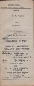
Conditions of sale by private contract issued by Bishop & Earl and H.A. Wilkinson and dated 25th July, 1949 between C.M. Taylor(seller) and F.W. Rogers + D.J. Rogers (buyers) land situate No. 47 Reginald Street Bendigo at present occupied by the purchaser as tenant, being part of Crown allotment 23 section 104C described in Crown grant volume 2052 folio 410334 as per plan of subdivision approved by the Bendigo Council, together with 4-roomed weatherboard dwelling and all sundry. Price 1,100 poundsorganization, business, h.a. & s.r wilkinson real estate -
 Bendigo Historical Society Inc.
Document - H.A. & S.R. WILKINSON COLLECTION: CONDITION OF SALE
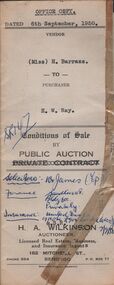
Conditions of sale by public auction issued by H.A. Wilkinson and dated 6th September 1950 between miss H. Barrass (seller) and H. W. Ray (buyer) for land situate No. 139 Queen Street Bendigo at present occupied by Mr. L.J. Lobb a tenant, being lot 1 on plan of subdivision made by Mr. A.E. Pritchard dated 13th August 1950 and being part of Crown allotment 10 section 90C, together with 5-roomed weatherboard dwelling and all sundry. Subject to existing weekly tenancy. Price 870 pounds.organization, business, h.a. & s.r wilkinson real estate -
 Bendigo Historical Society Inc.
Document - H.A. & S.R. WILKINSON COLLECTION: CONDITION OF SALE
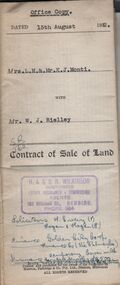
Contract of sale of land issued by H.A. Wilkinson and dated 15th August, 1952 between Mrs. L.M. & Mr. K. J. Monti (sellers) and Mr. W.J. Rielley for land being Lot 3 on plan of subdivision lodged in the office of titles in red ink No. 5062838 and being part of Crown allotment 20A section 16, City of Bendigo, Parish of Sandhurst, County of Bendigo and situate in Napoleon Crescent, White Hills, together with 6-roomed weatherboard dwelling and all sundry. Price 2,850 pounds.organization, business, h.a. & s.r wilkinson real estate -
 Bendigo Historical Society Inc.
Document - H.A. & S.R. WILKINSON COLLECTION: CONDITION OF SALE
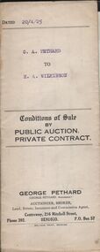
Conditions of sale by private contract dated 20th April 1925 between G. A. Pethard as seller and H. A. Wilkinson as buyer. Contract issued by George Pethard Auctioneer for sale of land situate in Elizabeth Street Nyah West being lot 100 on plan of subdivision No. 6415 lodged in the office of titles and being part of Crown Allotment 11 Parish of TynTynder West County of Tatchera described in certificate of title volume 4642 Folio 928297, together with 4-roomed weatherboard dwelling. Price 518 pounds.organization, business, h.a. & s.r wilkinson real estate -
 Bendigo Historical Society Inc.
Document - H.A. & S.R. WILKINSON COLLECTION: CONTRACT OF SALE
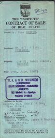
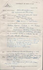
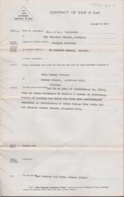
Contract of sale of real estate between Mr. R.A. Santon (vendor) and Mr. A.L. & A.K. Stringer (purchaser) dated 17th, July, 1962. Solicitor for vendor: Messrs. E.S. Cahill & Son, View Street, Bendigo. Solicitor for purchaser: Messrs Watson, James & Rogers, Bull Street, Bendigo. Property: Lot 21, Mahon Avenue, Bendigo, being lot 21 on plan of subdivision no. 31961 lodged in the office of titles parish of Sandhurst and being the whole of the land comprised in certificate of title volume 8310 folio 930 having a frontage of 53 feet to Mahon Avenue by a depth of 120 feet. Price 550 pounds.organization, business, h.a. & s.r wilkinson real estate -
 Bendigo Historical Society Inc.
Document - H.A. & S.R. WILKINSON COLLECTION: CONTRACT OF SALE
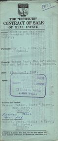
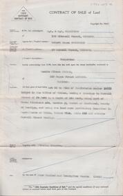
Contract of sale of real estate dated 12th April, 1961 between Bendigo and Eaglehawk Star Permanent Building Society (vendor) and Mr.E.A. & Mrs. L.M. Spence (purchaser). Solicitor for vendor: Messrs. Watson, James & Rogers, Bull Street, Bendigo. Solicitor for purchaser: Messrs. Hyett, Willis & Hyett, Bull Street, Bendigo. Property: vacant land corner Holdsworth Road and Britton Street, Bendigo being lot 3 on plan of subdivision No. 52449, having a frontage of 56 feet 7 inches with a width at the rear of 58 feet 5 inches with a depth of 97 feet 5.5 inches being part of crown allotment 31 section F at Bendigo described in Crown volume 8242 folio 057. Price 410 pounds.organization, business, h.a. & s.r wilkinson real estate -
 Bendigo Historical Society Inc.
Document - H.A. & S.R. WILKINSON COLLECTION: CONTRACT OF SALE
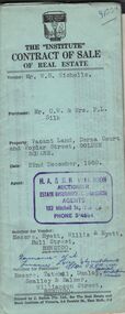
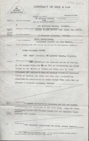
Contract of sale of real estate dated 22nd December, 1960 between Mr. W. B. Nicholls (vendor) and Mr. C. W. & Mrs. F. L. Silk (purchaser). Solicitor for vendor: Messrs Hyett, Willis & Hyett, Bull Street, Bendigo. Solicitor for purchaser: Messrs. Tatchell, Dunlop, Smalloy & Balmer, Williamson Street, Bendigo. Property: vacant land corner Derna Court and Poplar Street, Golden Square, being lots 20,21,22,23,24, 25, 26 and 27 fronting Derna Courton plan of subdivision no. B80611 and lot 1 on plan of subdivision no. 51583 lodged in the office of titles and being part of Crown allotment 11 section 24A at Bendigo described in Crown grant volume 8217 folio 121. Price 4,900 pounds .organization, business, h.a. & s.r wilkinson real estate -
 Bendigo Historical Society Inc.
Document - H. A. & S. R. WILKINSON COLLECTION: CONTRACT OF SALE
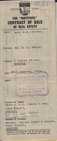
Contract of sale of real estate dated 22nd January, 1966 between Mrs. M. R. Potter (vendor) and Mr. M. L. Smart (purchaser). Solicitor for vendor: Messrs. E. S. Cahill & Son, View Street, Bendigo. Solicitor for purchaser: Messrs. Watson, James & Rogers, Bull Street, Bendigo. Property 3 Atkins Street, Bendigo being lot 1 on plan of subdivision No. 35034 lodged in the office of titles being part of Crown allotment 516B section K land described in certificate of title volume 8103 folio 921 together with all floor coverings, blinds, curtains and electric light fittings and shades. Price 2,500 pounds.organization, business, h.a. & s.r wilkinson real estate -
 Bendigo Historical Society Inc.
Document - H. A. & S. R. WILKINSON COLLECTION: CONTRACT OF SALE
Contract of sale of real estate dated 3rd December, 1964 between Mr. J. M. Gill (vendor) and Mr. C. Sartori (purchaser). Solicitor for vendor: Messrs. E. S. Cahill & Son, View Street, Bendigo. Solicitor for purchaser: Mr. H. E. Every, Dispensary Walk, Bendigo. Vacant land, Lot 16 hunter avenue, California Gully being lot 16 on plan of subdivision No. 55883 being part of Crown allotment 226 section N land described in certificate of title volume 8158 folio 238. Price 120 pounds.organization, business, h.a. & s.r wilkinson real estate -
 Bendigo Historical Society Inc.
Document - H. A. & S. R. WILKINSON COLLECTION: CONTRACT OF SALE
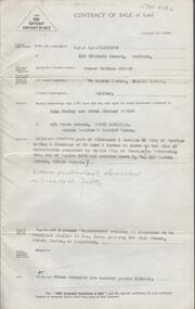
... being lot 29 on plan of subdivision No. 60209 land described... Morsehead Court, White Hills being lot 29 on plan of subdivision ...Contract of sale dated 16th July 1964 between Mr. W. B. & W. B. Nicholls (vendor) and Mr. A. E. & Mrs B. Stephens (purchaser). Solicitor for vendor: Messrs. Macaboy, Taylor & Taylor, Hargreaves Street, Bendigo. Solicitor for purchaser: Mr. H. E. & Mrs. B. M. Stephens. Lot 29 Morsehead Court, White Hills being lot 29 on plan of subdivision No. 60209 land described in certificate of title volumr 8434 folio 603. Price 3950 pounds.organization, business, h.a. & s.r wilkinson real estate -
 Bendigo Historical Society Inc.
Document - H. A. & S. R. WILKINSON COLLECTION: CONTRACT OF SALE
Contract of sale of real estate dated 18th December, 1963 between Mr G. A. & Mrs. N M. Wells (vendor) and Mr. H. G. & Mrs. M. E. Stephenson (purchaser). Property: 82 Hargreaves Street, corner Arnold Street, Bendigo, being lot 2 on plan of subdivision No. 28382 lodged in the office of titles, being part of Crown allotment 15 section 92C land described in certificate of title volume 4335 folio 826 together with floor coverings, blinds, curtains, electric light fittings and shades, gas stove in kitchen and gas fire heater in lounge room. Price: 3,250 pounds.organization, business, h.a. & s.r wilkinson real estate -
 Bendigo Historical Society Inc.
Document - H. A. & S. R. WILKINSON COLLECTION: CONTRACT OF SALE
... Bendigo being lot 3 on plan of subdivision No. 52992 land... of subdivision No. 52992 land described in certificate of title volume ...Contract of sale of real estate dated 8th November, 1963 between Mr. R. P. & Mrs. M. O. Miller (vendor) and Mr. E. C. Spence (purchaser). Solicitor for vendor: Watson, James & Rogers, Bull Street, Bendigo. Solicitor for purchaser: Watson, James & Rogers, Bull Street, Bendigo. Property: Sterry Street, West Bendigo being lot 3 on plan of subdivision No. 52992 land described in certificate of title volume 8399 folio 464. Price: 400 pounds.organization, business, h.a. & s.r wilkinson real estate -
 Bendigo Historical Society Inc.
Document - H. A. & S. R. WILKINSON COLLECTION: CONTRACT OF SALE
... of subdivision No. 56256 land described in certificate of title volume..., Golden Square being lot 2 on plan of subdivision No. 56256 land ...Contract of sale of real estate dated 18th December, 1962 between Mr. J. Coco & Mr. M. Storti (vendor) and Mr. E. A. & Mrs. D. J. Sprigg (purchaser). Solicitor for vendor: Watson, James & Rogers, Bull Street, Bendigo. Solicitor for purchaser: E. S. Cahill & Son, View Street, Bendigo. Property: Lot 2 McKenzie Street West, Golden Square being lot 2 on plan of subdivision No. 56256 land described in certificate of title volume 8375 folio 655. Price 4,000 pounds. Attached 5 letters between the parties and tradies detailing jobs to be done on the property.organization, business, h.a. & s.r wilkinson real estate -
 Bendigo Historical Society Inc.
Document - H. A. & S. R. WILKINSON COLLECTION: CONTRACT OF SALE
Contract of sale dated 27th March, 1958 between Mr. V. V. & Mrs R. M. Wodetzki (vendor) and Mr. L. J. & Mrs. T. M. Pascoe (purchaser). Solicitor for vendor: Watson, James & Rogers, Bull Street, Bendigo. Solicitor for purchaser: Watson, James & Rogers, Bull Street, Bendigo. Property 4 Malcom Street, Bendigo being lot 5 on plan of subdivision No. 22158(?) lodged in the office of titles and being part of Crown allotment8 and 9 section 165C land described in certificate of title volume 7597 folio 005(?), together with all floor coverings, blinds, curtains, electric light fittings and shades with the exception of crystal hade in the hall. "Shor" washing machine, "Masters" early electric stove. Price: 6,200 pounds. Attached Statement pursuant to section 34 of the estate agents act 1956 and 4 hand written notes.organization, business, h.a. & s.r wilkinson real estate -
 Bendigo Historical Society Inc.
Document - H. A. & S. R. WILKINSON COLLECTION: CONTRACT OF SALE
Contract of sale of land dated 11th January, 1956 between Mr. W. S. Bond (vendor) and Mr. R. B. Scott (purchaser). Property: surface and down to a depth of 50 feet below the surface of that piece of land being lot 71 on plan of subdivision lodged in the office of titles No. 16993 being part of Crown allotment 441B section H Parish of Sandhurst city of Bendigo and situate Corner Neale & Burrell Streets, Bendigo, together with brick dwelling, all sundry outbuildings, all floor coverings, all blinds, all electric light fittings and shades, Hoover washing machine, all curtains except those in the 2 front rooms and electric stovette. Price: 3,950 pounds.organization, business, h.a. & s.r wilkinson real estate -
 Bendigo Historical Society Inc.
Document - H. A. & S. R. WILKINSON COLLECTION: CONTRACT OF SALE
Contract of sale of land dated 25th August, 1956 between Mr. A. T. & Mrs. I. M. H. James (vendor) and Mr. J. H. Strange (purchaser). Property: lot 1 on plan of subdivision no. 19491 lodged in the office of titles being part of Crown allotment 24 Parish of Sandhurst County of Bendigo, land described in certificate of title volume 7646 folio 003 and situate Beischer Street, Bendigo, together with 5 roomed weatherboard dwelling, all sundry outbuildings, all floor coverings, blinds, curtains, Metro fridge, "Mettres" electric range, Hoover washing machine and all electric light fittings and shades. Price: 2,780 pounds. Attached 5 hand written notes .organization, business, h.a. & s.r wilkinson real estate -
 Bendigo Historical Society Inc.
Document - H. A. & S. R. WILKINSON COLLECTION: CONTRACT OF SALE
Contract of sale of land dated 24th February, 1956 between Mrs. D. I. Smith (vendor) and Mr. A. W. & Mrs. N. Pulfer (purchaser). Solicitor for vendor: E. C. Cohen. Solicitor for purchaser: Hyett, Willis & Hyett. Property: land being lot 13on plan of subdivision No. 21180 lodged in the office of titles, being part of Crown allotment 457 section H Parish of Sandhurst described in certificate of title volume7793 folio 150 and situate No. 3 Margaret Crescent, Bendigo, together with brick veneer dwelling and all sundry. Price: 5,500 pounds.organization, business, h.a. & s.r wilkinson real estate -
 Bendigo Historical Society Inc.
Document - H. A. & S. R. WILKINSON COLLECTION: CONTRACT OF SALE
Contract of sale of land dated 5th November 1955 between Mr. L. H. & Mrs. M Davis (vendor) and Misses T. A. & I. Pithie (purchaser). Solicitor for vendor: H. E. Every. Solicitor for purchaser: Neal Woodward. Property: Lot 4 on plan of subdivision No.21517 lodged in the office of titles being part of Crown allotment 351 section E, land described in certificate of title volume 7731 folio 178, together with 5 room brick dwelling also all floor coverings, blinds, curtains, electric light fittings and shades, electric stovette and stand. Price: 6,000 pounds.organization, business, h.a. & s.r wilkinson real estate -
 Bendigo Historical Society Inc.
Document - H. A. & S. R. WILKINSON COLLECTION: CONTRACT OF SALE
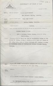
Contract of sale of land dated 30th August 1955 between Mr. E. M. Hopper (vendor) and Mr. J. H. & Mrs. E. E. Parker (purchaser). Property: land being part of Crown allotment3 section 5A having a frontage of 38 feet 8 inches as shown on plan of subdivision consented by the city of Bendigo on Wednesday 6th August, 1955 and situate block 5, No. 110 Penton Street, Golden Square, together with 5 roomed weatherboard dwelling as inspected to be completed similar to Mrs. James property 650 High Street, Golden Square. Price: 3,200 pounds. .organization, business, h.a. & s.r wilkinson real estate -
 Bendigo Historical Society Inc.
Document - H. A. & S. R. WILKINSON COLLECTION: CONTRACT OF SALE
Contract of sale of land dated 17th August, 1955 between Mr. H. B. Morgan (vendor) and Mr. L. H. Parsons (purchaser). Property: land being lot 3 on plan of subdivision lodged in the office of titles, having a frontage of 50 feet by a depth of 150 feet, being part of Crown allotment 547section H and situate in Osborne Street, Bendigo, together with 5 roomed weatherboard dwelling and all sundry. Price: 3,300 pounds.organization, business, h.a. & s.r wilkinson real estate -
 Bendigo Historical Society Inc.
Document - H. A. & S. R. WILKINSON COLLECTION: CONTRACT OF SALE
Contract of sale of land dated 12th July 1955 between Mr. C. Naismith (vendor) and Mr. J. M. Parsons (purchaser). Property: land being lot 20 on plan of subdivision No. 22101 part of Crown allotment 60 section D Parish of Mandurang, County of Bendigo and being land described in certificate of title volume 7925 folio 69 and situate Archer Street, Kangaroo Flat. Price: 140 pounds.organization, business, h.a. & s.r wilkinson real estate -
 Bendigo Historical Society Inc.
Document - H. A. & S. R. WILKINSON COLLECTION: CONTRACT OF SALE
Contract of sale of land dated 9th February 1955 between Mr. R. J. Sanderson (vendor) and Mr. L. A. Pitson (purchaser). Property: Lot 55 on plan of subdivision No. 16998 lodged in the office of titles, having a frontage to Burrell Street of 50 feet by a depth of 140 feet, being part of Crown allotment 432 section H Parish of Sandhurst County of Bendigo, land described in certificate of title volume 7314 folio 636 and situate Burrell Street, Bendigo, together with the fencing thereon. Price: 425 pounds.organization, business, h.a. & s.r wilkinson real estate -
 Bendigo Historical Society Inc.
Document - H. A. & S. R. WILKINSON COLLECTION: CONTRACT OF SALE
Contract of sale of land dated 12th January, 1955n Mr. L. W. & Mrs. L. M. Dennis (vendor) and Mrs. A. M. Praetz (purchaser). Property: land delineated and coloured purple on the map in the margin being lot 11 on plan of subdivision 21180 lodged in the office of titles being part of Crown allotment 457 section H Parish of Sandhurst, City of Bendigo, land described in certificate of title volume 7793 folio 149 and situate 7 Margaret Crescent, Bendigo, together with 5 rooms weatherboard dwelling and all sundry buildings on said land, also all floor coverings, blinds and electric light fittings and shades. Price: 4,150 pounds.organization, business, h.a. & s.r wilkinson real estate -
 Bendigo Historical Society Inc.
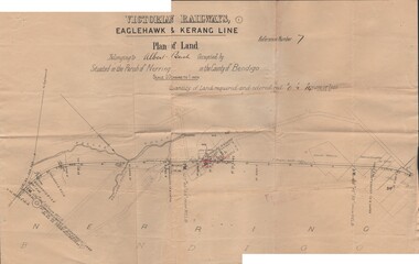
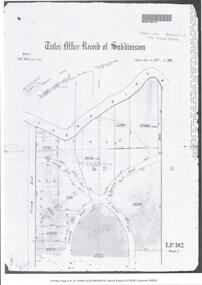
Document - BUSH COLLECTION: PLANS PERTAINING TO LAND OF S. A. BUSH
A: Plan of subdivision of Allots 6, 7, 8, 15 & 16, Sec. 62C, City of Bendigo (The Property of Albert Bush, Esq.) - Plan is torn in half forming two pieces (see 'Condition'. Pinned note attached to one piece. B: Victoria Railways, Eaglehawk & Kerang Line (Albert Bush land, Parish of Nerring, County of Bendigo.person, individual, bush collection - personal -
 Bendigo Historical Society Inc.
Document - CERTIFICATE OF TITLE
... Certificate of titles and its subdivision plans for land... MELBOURNE Certificate of titles and its subdivision plans for land ...Certificate of titles and its subdivision plans for land bought by George Lansell in Toorak. Dated 27th August 1874.melbourne -
 Bendigo Historical Society Inc.
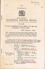
Book - 1958 VICTORIA ANNO TERTIO ELIZABETHÆ SECUNDÆ REGINÆ NO. 6284, 23/2/60
A small book owned by Accountant & Auditor Harold Curnow dated 23/2/60 detailing "An Act to consolidate the Law relating to the Sale and Occupation of Crown Lands." on page 61 it also has a 2/10/61 newspaper article and a June 27, 1962 page from the Victoria Gazette both of them detailing the Laws. The first page is written as following "Harold Curnow 1958. VICTORIA ANNO SEPTIMO ELIZABETHÆ SECUNDÆ REGINÆ No. 6284. An Act to consolidate the Law relating to the Sale and Occupation of Crown Lands, [30th September, 1958.] Be it enacted by the Queen's Most Execellent Majesty by and with the advice and consent of the legislative Assembly of Victoria in this present Parliament assmled and by the authority of the same as follows (that is to say) 1. This act may be cited as the Land Act 1958. and shall come into operation on a day to be fixed by proclamation of the Governor in council published in the Goverment Gazette, and is divided into Parts Divisions and Subdivisions as Follows:-"victoria