Showing 1315 items matching "looking west"
-
![Construction of the electric tram line in Cotham Road [Kew]](/media/collectors/550653872162f11fb04854aa/items/662890b16214a76cee3ec4c2/item-media/662891076214a76cee3ed17d/item-fit-380x285.jpg) Kew Historical Society Inc
Kew Historical Society IncPhotograph - Construction of the electric tram line in Cotham Road [Kew], E.J. Dower, 1913
... for electric trams, looking west / 1913"... Kew for electric trams, looking west / 1913" The fifth of six ...One of a small album of six photographs of the construction of the Cotham Road tramline in Kew, taken by Edgar James Dower in the second decade of the twentieth century. The reverse of each photo contains notes, written over time by the photographer, which are contained in the 'Inscriptions' field. Born and raised in Olinda, Dower's family later moved to Surrey Hills. He worked as an adult as a clerk in the city office of the Metropolitan Gas Company, and in his role as a 'collector', he was able to photograph scenes including the construction of tram and train lines and associated buildings in Kew, Hawthorn, Camberwell and Surrey Hills. Later he established a real estate agency with his brother - the E.J. Dower Real Estate Agency, Dandenong Office. The album as a whole can be viewed separately as the parent file.The image is an historically significant record of the development of transport infrastructure which was used to connect Victorians in the first two decades of the twentieth century. This development resulted from increases in population and the consequent extension of Melbourne's suburbs. The photographs in the album, as well as Dower's single photos mounted on card, individually and collectively richly detail the labour of workers and the tools and machinery used to create and extend Melbourne's tram and train networks in the years preceding and during World War 1.The fifth of six annotated photos in an album of photographs of the construction of the St Kilda to Kew electric tram line, taken in Cotham Road, Kew, by the amateur photographer, Edgar James Dower, in 1913. The album contains images detailing the preparation for the laying of the tracks plus work laying the line. The photographer notes on a number of the photos that the metal tracks were collected from the Hawthorn railway siding. The album, together with other phots by E.J. Dower has been made available by the owners for the Kew Historical Society to digitise and publish online and in print.Annotation verso: "Preparing tram line Cotham Road Kew for electric trams, looking west / 1913"keywords, theme -- connecting victorians by transport and communications, theme -- travelling by tram, photographers -- edgar james dower, cotham road -- kew (vic.) -
 Surrey Hills Historical Society Collection
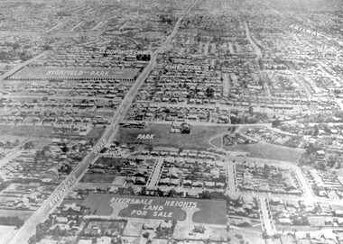
Photograph - Aerial view Riversdale Heights Estate area, c1923
... of the area near the corner of Warragul and Riversdale Roads looking... LOOKING WEST c. 1936" [The reference to the sale in the Box Hill... the original on the mount: "SOUTH SURREY HILLS LOOKING WEST c. 1936 ...This was probably part of a real estate promotion for the sale of the Riversdale Heights Estate. This was subdivided by Messrs. Duncan and Weller. Of the allotments offered, 30 were sold and realised £4600. Date of this sale was c December 1923. This suggests that the date This are was one of the last pieces of former rural land to be sub-divided for housing in Surrey Hills.The land between it and South Surrey Park was sub-divided post WW1, hence the naming of the streets after sites of WW1 battles.A black and white reproduction of an aerial photo of the area near the corner of Warragul and Riversdale Roads looking west towards the city. Some features have been identified by name including the Riversdale Heights Estate, which was being sub-divided. North and South Courts are shown. Other roads (unmarked) in the foreground are Graham Street, Allie Street, Thistle Street, Lille Street, Amiens Street, and Marne Street. Beyond these is the area marked 'PARK' (South Surrey Park), which is devoid of vegetation. Areas of Camberwell and Canterbury are also shown. The area covered extends to beyond St Dominic's Church. The original is mounted on a cream deckle-edged paper.Beneath the original on the mount: "SOUTH SURREY HILLS LOOKING WEST c. 1936" [The reference to the sale in the Box Hill Reporter of December 1923 found on Trove suggests that this date is not accurate.] Rear top LH corner of original in Jocelyn Hall's handwriting: "For Centre / from Mr James Long"riversdale heights estate, riversdale road, allie street, south surrey park, lille street, thistle street, amiens street, marne street, south court, north court, duncan and weller, real estate sales, graham street, st dominics church, highfield park, canterbury primary school, aerial photo -
 Eltham District Historical Society Inc
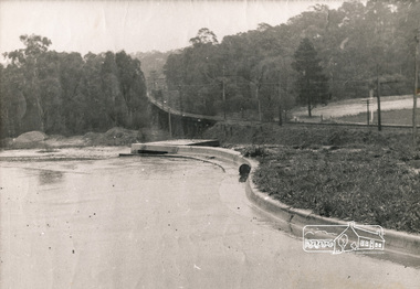
Photograph, George W. Bell, Looking towards trestle bridge from new Shire Hall, 1965c
... Black and white photograph looking west to railway bridge... george w bell collection Black and white photograph looking west ...Black and white photograph looking west to railway bridge over Diamond Creek from Shire Office carpark c.1965.bridges, railways, eltham, diamond creek, eltham shire office, george w bell collection -
 Port Melbourne Historical & Preservation Society
Photograph - Port Melbourne foreshore, Lyn Allison, Nov 1992
... Lasercopy of photo of Port Melbourne foreshore, looking... of Port Melbourne foreshore, looking west toward Station Pier ...From a series of photos taken by Lyn Allison, then a Councillor of the City of Port Melbourne, to record the condition of Port Melbourne's beachesLasercopy of photo of Port Melbourne foreshore, looking west toward Station Pier. Taken by Cr Lyn Allison, Nov 1992.'Nov 92'built environment - civic, natural environment - beaches and foreshore, lyn allison -
 Whitehorse Historical Society Inc.
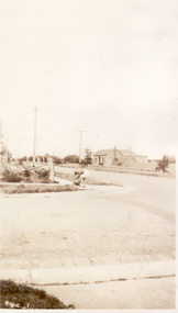
Photograph, Corner of Harrison and Thomas Streets, Mitcham, 1948
... Streets, Mitcham. Looking West. (Photograph taken from front.... Looking West. (Photograph taken from front of Kohlman house ...Black and white photo of Corner of Harrison and Thomas Streets, Mitcham. Looking West. (Photograph taken from front of Kohlman house).harrison street, mitcham, thomas street -
 Camberwell Historical Society
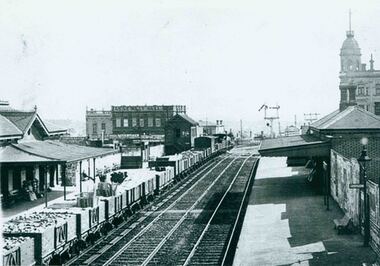
Photograph, Camberwell Victoria, view of the railway station, c. 1930
... Print of photograph of Camberwell Railway Station looking... looking west. Inscription states 'Camberwell Victoria, view ...Print of photograph of Camberwell Railway Station looking west. Inscription states 'Camberwell Victoria, view of the railway station, c. 1930' Camberwell Victoria, view of the railway station, c. 1930camberwell -
 The Beechworth Burke Museum
Photograph, 1907-8
... . The photo was taken of Matthews Gully looking west. Sluicing.../ Cocks Pioneer G&T. ?? Co NZ/ No2 Site looking West/ 1907-8/ (7).... The photo was taken of Matthews Gully looking west. Sluicing ...The photo from 1907-8 is a sepia print, depicting a small valley with building at base. There are flumes visible above areas of water, trees on hills and a few small cottages on the hillside. Cock's Pioneer Gold & Tin Sluicing Co NZ No 2 Site. The photo was taken of Matthews Gully looking west. Sluicing was undertaken in the area from 1900 to 1942 with some short breaks between these periods. The image depicts a location mined by Cocks Pioneer Gold and Tin Sluicing Company (as recorded on the annotation on the card mount) The Cocks Pioneer Gold and Tin Mines N.L was one of El Dorado's two largest open cut sluicing mines of the 20th Century. The other was named the Cocks El Dorado Gold Dredging Company. The Cocks Pioneer Mines operated from 1901 until 1941 and found a total of 117,378 ounces of Gold and 1,673 tones of tin concentrates over these years. The Cocks company was formed in 1898 and operated until 1941. Open cut sluicing involved the use of high-powered hoses which used the centrifugal sand pump system (known as hydraulic sluicing) which broke down the soil which was then processed for gold and other precious metals. From 1914 , four years after this image was captured, the company reformed to Cocks Pioneer Gold and Tin Mines NL (previously it was known as Cocks Pioneer Sluicing Co) and undertook large scale sluicing operations until 1929 and then 1934-1941. El Dorado is located on Reedy Creek and is surrounded by forested country to the north and east. It is 20 km east of Wangaratta in Victoria's regional north-east. John Cock was the son of a Cornish minor who arrived in El Dorado in 1858. Cock founded his gold and tin mining company which ran successfully for many years in the El Dorado region. It was an open cut sluicing company because of the abandonment of underground mining after this was deemed too dangerous. In 1935 Cock's El Dorado Company commissioned the floating dredge which is still visible in El Dorado today. The dredge was built by the Thompson engineering works, Castlemaine, and weighed over 2,000 tones and today has a place on the Victorian Registers of historic buildings. Interestingly, the name El Dorado does not derive from the gold in the region, but from the Barambogie pastoral run completed by William Baker in 1840-1841. Gold was discovered in El Dorado 1854 but the gold was too deep for individual prospectors to find, it required the use of heavy machinery.The search for gold is ingrained into the history of Victoria and therefore, images like this one which portray an open cut sluicing site can reveal important information for society and technology for the date when the photograph was taken. This image is of important historical significance for its ability to convey information about sluicing and the methods used to find gold in 1910. It also shows a location where sluicing was undertook which provides insight into the impact of sluicing on the environment at a time when it was done. This image is important for current research into the history of El Dorado, a small regional location near Wangaratta in Victoria's North East. Therefore, this image has the capacity to be beneficial for research into society and the motivations of those living and working in this region during this period and therefore, has social significance. The Beechworth Burke Museum has additional images relating to gold sluicing and El Dorado which can be analysed and studied alongside images like this one.Sepia coloured rectangle photograph printed on gloss photographic paper Reverse: 1997. 2613/ A02613/ No2 site/ Matthews Gully/ Cocks Pioneer G&T. ?? Co NZ/ No2 Site looking West/ 1907-8/ (7)sluicing, hydraulic sluicing, 1907, 1908, mining, cock's pioneer gold & tin sluicing co nz, nz, site no 2, matthews gully, west, valley, building, cottages, hillside, trees, water, gold and tin mine -
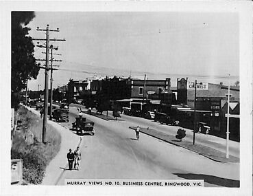 Ringwood and District Historical Society
Photograph/Postcard, Souvenir photograph - Murray Views No.10. Business Centre, Ringwood, Vic
... Warrandyte Road looking west along Maroondah Highway, Ringwood..." souvenir photograph from Warrandyte Road looking west along ...Black and white "Murray Views" souvenir photograph from Warrandyte Road looking west along Maroondah Highway, Ringwood. Circa 1940s. -
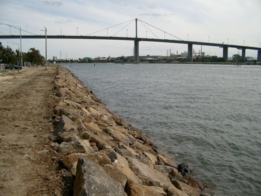 Port Melbourne Historical & Preservation Society
Photograph - West Gate Bridge, Glen Stuart, 6 Oct 2002
... Colour photo of West Gate Bridge over Yarra River looking... Colour photo of West Gate Bridge over Yarra River looking west ...Colour photo of West Gate Bridge over Yarra River looking west. Shows rock wall to stabilise bank. Fishermens Bendbuilt environment - civic, engineering - bridges, west gate bridge, yarra river -
Port Melbourne Historical & Preservation Society
Photograph - Graffiti below Graham Street overpass, Port Melbourne, Pat Grainger, 1991
... Street overpass, taken from Station Street looking West toward... overpass, taken from Station Street looking West toward the tram ...Original colour photograph of graffiti below the Graham Street overpass, taken from Station Street looking West toward the tram linebuilt environment - civic, arts and entertainment - visual arts, graham street -
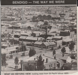 Bendigo Historical Society Inc.
Newspaper - JENNY FOLEY COLLECTION: WHAT AN HISTORIC VIEW
... an historic view: looking west from st Paul's about 1855.... ''The way we were'' from 1999. What an historic view: looking west ...Bendigo Advertiser ''The way we were'' from 1999. What an historic view: looking west from st Paul's about 1855.newspaper, bendigo advertiser, the way we were -
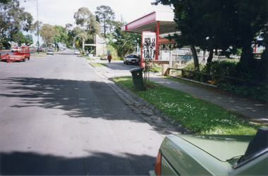 Whitehorse Historical Society Inc.
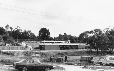
Photograph, Whitehorse Road, Mitcham - Service Road, 1/10/2000 12:00:00 AM
... Road, Mitcham, looking west to shop and Service Station... in Whitehorse Road, Mitcham, looking west to shop and Service Station ...Coloured photograph of north Service Road in Whitehorse Road, Mitcham, looking west to shop and Service Station on the corner of Alexander Street Mitcham.service roads, whitehorse road mitcham, alexander street, mitcham -
 Whitehorse Historical Society Inc.
Photograph, Whitehorse Road, Blackburn, 6/01/2001 12:00:00 AM
... , looking west from pedestrian overpass. Leader Newspaper Offices... of Whitehorse Road, Blackburn, looking west from pedestrian overpass ...Black and white photograph of Whitehorse Road, Blackburn, looking west from pedestrian overpass. Leader Newspaper Offices - formerly Cottees - on left.whitehorse road, blackburn, blackburn pedestrian overpass, leader community newspapers -
 Whitehorse Historical Society Inc.
Photograph, Vitclay, 1995
... by demolished sheds. Springfield Road, Blackburn North, looking West..., Blackburn North, looking West from Primrose Street. Vitclay ...Vitclay Chimney, prior to Demolition in 1995, surrounded by demolished sheds. Springfield Road, Blackburn North, looking West from Primrose Street.vitclay, springfield road, blackburn north, potteries, clay industries -
 Whitehorse Historical Society Inc.
Photograph, Whitehorse Road, Blackburn, 2012
... Coloured photograph of Whitehorse Road Blackburn looking... Coloured photograph of Whitehorse Road Blackburn looking west ...Coloured photograph of Whitehorse Road Blackburn looking west, Surrey Road enters Whitehorse Road near the red building on the right - 2012whitehorse road, blackburn, roads, transport -
 Whitehorse Historical Society Inc.
Photograph, Blackburn, South Parade, 2012
... Coloured photograph of South Parade Blackburn looking west... Coloured photograph of South Parade Blackburn looking west. Bus ...See NP4006Coloured photograph of South Parade Blackburn looking west. Bus on right is dropping people off at south side of the Blackburn station - 2012south parade, blackburn, shops, shopping -
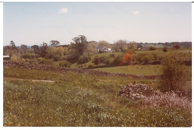 Buninyong & District Historical Society
Photograph - Original Photograph, View from Lal Lal St. 1982, 1982
... Colour photograph, view from Lal Lal St. looking west... photograph, view from Lal Lal St. looking west in1982, drystone wall ...Colour photograph, view from Lal Lal St. looking west in1982, drystone wall runs across, catholic church in backgroundbuninyong, lal lal street, drystone wall, catholic church, landscape -
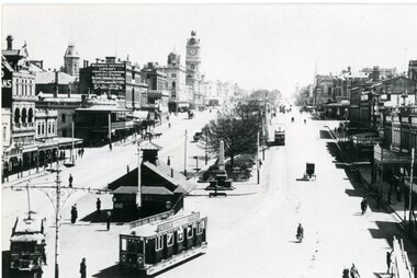 Ballarat Tramway Museum
Photograph - Black and White - ESCo trams at Grenville St, Rose Stereograph Co, 1913c
... ESCo trams at the Grenville St terminus, looking west along... two ESCo trams at the Grenville St terminus, looking west ...One of the trams is a Sebastopol-type tram No 22. Has the large shelter in the background and another tram in the view. Taken c1913, following the introduction of the Sebastopol type tram. From a Rose Series postcard - Rose Number 1710. Note the Mechanics Institute advertising sign on their building advertising the institute rather than a company. The 8-hour monument at the end of the central median can be seen. See item 9012 for a printed illustration of this photograph,Yields information about the operation of ESCo trams in Sturt St and in particular the Sebastopol type.Black and white copy photograph of a postcard showing two ESCo trams at the Grenville St terminus, looking west along Sturt St.tramways, trams, ballarat, sturt st, esco, grenville st, sebastopol type, tram 22 -
Melbourne Tram Museum
Ephemera - Christmas Card, Melbourne & Metropolitan Tramways Board (MMTB), 1970's
... of Collins St looking west from Russell St, from the MMTB... looking west from Russell St, from the MMTB. Not dated ...Christmas card, printed - 8 pages featuring a photo of Collins St looking west from Russell St, from the MMTB. Not dated.trams, tramways, mmtb, christmas, greetings cards, collins st -
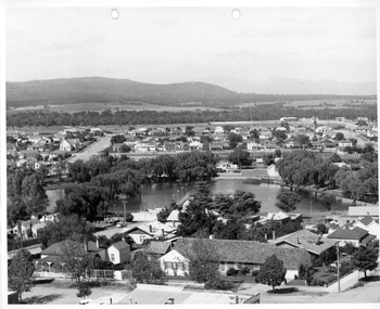
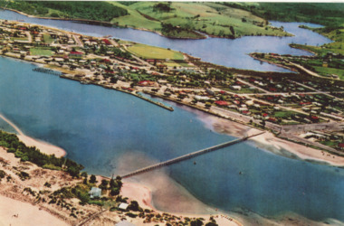 Lakes Entrance Historical Society
Photograph - Lakes Entrance, 1952c
... Colour photograph of town from Myers Street looking west... Myers Street looking west showing footbridge, Cunninghamme Arm ...Colour photograph of town from Myers Street looking west showing footbridge, Cunninghamme Arm and North Arm Lakes Entrance Victoriaaerial photograph, township -
 Ringwood and District Historical Society
Photograph, Holy Spirit School, North Ringwood, viewed from Jull Road - 1981
... Written on back of photograph, "E620. 1981. Looking west..., "E620. 1981. Looking west from Jull Road. North Ringwood at Holy ...Written on back of photograph, "E620. 1981. Looking west from Jull Road. North Ringwood at Holy Spirit School". -
Tatura Irrigation & Wartime Camps Museum
Photograph, 1950
... of camp looking west (in 1950) Army huts spread across middle... and white photograph. General view of camp looking west (in 1950 ...Taken by photographer for State Rivers and Water Supply Commission.Medium sized black and white photograph. General view of camp looking west (in 1950) Army huts spread across middle - right to leftvictorian state rivers and supply commission, camp 13, murchison, water commission camp -
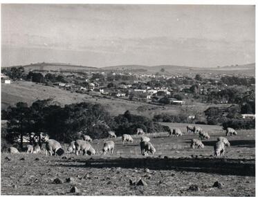 Hume City Civic Collection
Photograph, Early 1970s
... township looking west and taken from above the Goonawarra Winery... not extend far beyond Anderson Road to the west and Powlett Street ...The photograph was taken when Sunbury township did not extend far beyond Anderson Road to the west and Powlett Street to the east. The Paynes housing development can be seen scattered across the hillside between Gap Road and Mitchells Lane.A black and white photograph of a panoramic view of Sunbury township looking west and taken from above the Goonawarra Winery. Sheep are grazing on the hilside in the foreground.sunbury township, goonawarra winery, george evans collection -
 Stawell Historical Society Inc
Photograph, Cato Lake from top of clock tower c 1965
... Photo taken from top of clock tower c 1965 looking South... of the clock tower looking South West. c 1965.... of the clock tower looking South West. c 1965. Cato Lake from top ...Photo taken from top of clock tower c 1965 looking South West. Black Range in background. Stawell West State School is in the far top right just in front of a band of trees. The swimming pool is hidden by pine trees in the center of the lake and identified but a line of flag posts either side of the pool.Aerial black and white view of Cato lake. One photo is original and the other a copy. The photo was taken from the top of the clock tower looking South West. c 1965.stawell, streetscape -
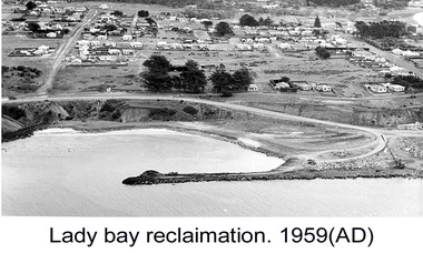 Glenelg Shire Council Cultural Collection
Photograph - Photograph - Lady Bay reclamation, c. 1960
... breakwater. Lady Bay Reclamation: Aerial view looking West showing... with man-made breakwater. Lady Bay Reclamation: Aerial view looking ...Port of Portland Authority archivesFront: (no inscriptions) Back: Lady Bay Reclamation 1959 (black pen, upper left)port of portland archives, lady bay, reclamation -
 Whitehorse Historical Society Inc.
Photograph, Vermont Intersection C.1967, C.1967
... Roads, Vermont, taken in 1967, looking West from outside Scout... of Canterbury, Mitcham & Boronia Roads, Vermont, taken in 1967, looking ...Part of Tim Shambrook's Collection for 'This is Vermont'. Not used.Coloured photo of Corner of Canterbury, Mitcham & Boronia Roads, Vermont, taken in 1967, looking West from outside Scout Hall and showing Vermont Shops.vermont scout hall, canterbury road, vermont, boronia road, mitcham road, shambrook, tim -
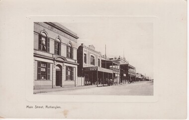 Rutherglen Historical Society
Image, Main Street, Rutherglen, c1900
... , Rutherglen looking west. Photo features the Bank of Australasia, S..., Rutherglen looking west. Photo features the Bank of Australasia, S ...Black and white postcard photograph of Main Street, Rutherglen looking west. Photo features the Bank of Australasia, S. Younkman's Auction Rooms and the Victoria Hotel.main street rutherglen, bank of australasia, s younkman & co, victoria hotel -
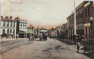 Kew Historical Society Inc
Postcard, High Str., Kew, c.1906
... Polychrome postcard of High Street, Kew looking west... of High Street, Kew looking west towards Kew Junction ...The Kew Historical Society's postcard collection includes views of Kew, Melbourne and Greater Melbourne as well as those including overseas scenes sent or received from Europe or the Middle East. They date from the 1890s to the 2000s. These postcards may or may not include the name of the publisher or printer. A number of the cards were published as parts of popular series. A way of dating early postcards is to identify whether the reverse was divided by a central line which became the norm after 1902 in the United Kingdom. However, other postcards produced after this date do not always conform to this print layout.Polychrome postcard of High Street, Kew looking west towards Kew Junction. The photograph was also printed in monochrome format by the publishers, with different names and additions.Reverse - (to) Miss __. J. Thompson, "Dry Lake", Kerang (from) Very sorry indeed to hear of your Mother's illness. Sincerely hope all quite well ere this. Still going about very tired waiting __ being away. Love to all M.B.L.high street -- kew (vic.), postcards -- kew (vic.), horse tram -- kew (vic.) -
Canterbury History Group
Photograph - Canterbury Road, Canterbury, c1910
... View from Wattle Valley Road of Canterbury Road looking... Road of Canterbury Road looking west. Canterbury Mansions ...View from Wattle Valley Road of Canterbury Road looking west. Canterbury Mansions, built 1889 as the Canterbury Club Hotel for William Malone is on left.canterbury, canterbury road, railway crossing, canterbury mansions, horse drawn vehicles, goldings hall -
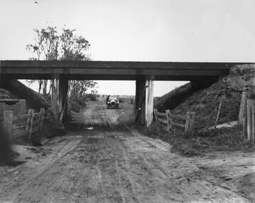 City of Kingston
Photograph - Black and white, c. 1920
... Road, looking west. A car has stopped on the road... of an unsealed underpass at Patterson Road, looking west. A car has ...This image is part of a larger collection of images from the Public Transport Corporation displaying train stations and streetscapes in what is now the City of Kingston.While the focus of this image is the train line running overhead, the unsealed nature of the road speaks to the progression of suburban development during the 1920s.Black and white image of an unsealed underpass at Patterson Road, looking west. A car has stopped on the road in the distance and man is standing on the duckboard leaning into the car.Round white sticker on reverse with black printed text: 177 Handwritten in red ink: 60% Blue ink stamped on reverse: COPYRIGHT / Public Transport Corporation / For re-ordering photographs / Please quote negative No ADV 300 / Enquiries C/- PTC Photographic Unit / Telephone switchboard 619 111patterson road, railway, trains, cars, unsealed roads